
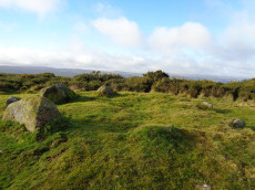
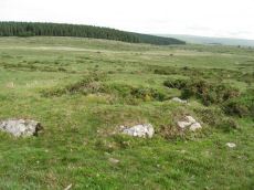
The Turner Classification of Cairns
Turner used the following clasifications for stone circles and cairns:
Listing of Turner Cairns: E Platform Circles
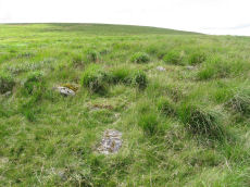
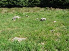
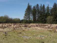
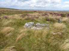
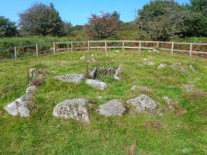
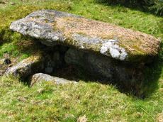
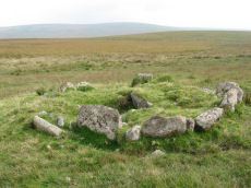
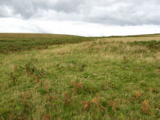
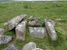
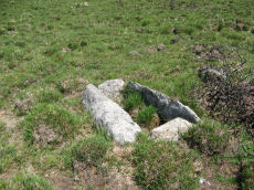
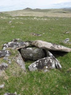
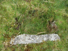
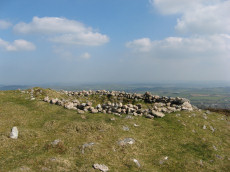
Deadmans Bottom F Platform Cairn Circle and Cist
Prehistoric Dartmoor Walks: Dartmoor Site: Guide to the Langcombe Brook & Deadman's Bottom Cists
OS Map: SX 61201 66983
HER: MDV5125
Megalithic Portal: 45733
PMD: Deadman's Bottom E.
Alternate name: Langcombe Brook 11 Platform Cairn Circle and Cist
Short Name: CT Deadmans F
Butler map: 50.3.11
Dixon Cist #: 57
Grinsell: SHA 12
DPD: 43
Barrow Report: 53
Dimensions (m): 5.5 x 0.4 C
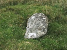
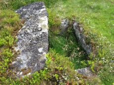
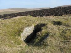
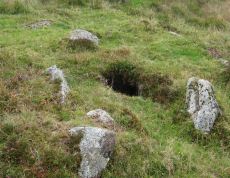
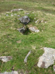
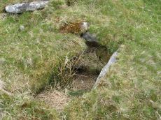
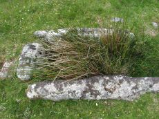
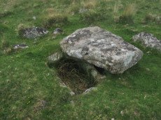
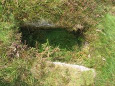
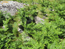
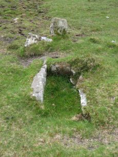
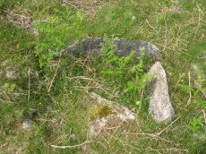
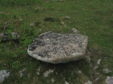
Notes: "Cist (Listed as 'F' by Worth) found at Deadman's Bottom, Langcombe, by Mr. Button. The cover-stone is still in position but the cist appears to have been rifled, the end and side-stones having been displaced at the north-east and southwest angles. Original length would appear to have been 2 feet 10 inches, and the width 1 foot 7 inches. The greatest length of the cover-stone is 4ft 9 inches and its greatest width 3 feet 1 1/2 inches." ... "A flat-topped cairn measuring 5.4m in diameter and standing a maximum of 0.4m high. A well-preserved cist 1.3m long, 0.6m wide and 0.15m deep is largely obscured by the coverstone". Lethbridge p.43 Langcombe Cist A (Upper Deadman's Bottom) - diagram p.43. nb. Not listed by Turner - assigned as "Platform Circle" type cairn due to description in NMR. Butler Langcombe Brook Cairn 11 - Vol. 3. Map 50.3 (pp.148-54 general plan of Langcombe Brook cairns p.151, diagram of Langcombe cists p.153).
Nearest Bus Stop: Lee Moor Clearview (6.5 km) [Route: 59]
Nearby sites: SX 61201 66983
Black Down W. Platform Cairn Circle and Cist
OS Map: SX 57398 91540
HER: MDV61332
Megalithic Portal: 45801
PMD: Black Down
Short Name: CT:BlackDown W
Butler map: 42.6
Butler Vol 5: p.58 & Fig.35
Dixon Cist #: 147
Dimensions (m): 6.5 x 0.6 C
Notes: Not located at SX 57409153 on 28/08/16. Butler SX57389153. NMR SX57469153."The cairn is 6 metres in diameter and 0.7 metres in height. The cist is 0.9 metres long with 2 end stones in the original position. Remains of a kerb are visible around the north west edge of the mound". 1.6km east of Higher Bowden. nb. Not listed by Turner - assigned as "Platform Circle" type cairn due to description in NMR. "A flat-topped cairn". Butler Black Down W. Vol. 2. Map 42.6 (diagram Vol 5. p.58).
Nearest Bus Stop: Okehampton Railway Station (3.4 km) [Route: 118,306,6A]
Nearby sites: SX 57398 91540
Throwleigh Common 6 Platform Cairn Circle and Cist
OS Map: SX 65203 89798
HER: MDV13020
PMD: Forder Brook
Short Name: CT:Throw 6
Dimensions (m): 1.5 x 0.25 C
Notes: Round cairn. Diameter 6.4 metres, height 1 metre. Cist 0.6 metres wide, oriented north-south. Central pit 1.5 metres by 1.1 metres by 0.25 meters deep. Situated on downslope edge of a natural terrace. Three edge set stones lying parallel to each other are exposed in the central pit. The two eastern ones may represent the edges of a cist with a length or width of 0.6 metres. A number of edge set stones around the edge represent a kerb. Gorse covered. NOTE: NMR gives location as SX 6519 8978.
The overgrown feature in the photo from 17/03/2025 is possibly this feature but it is a considerable distance from the NMR grid reference. That is located at SX 65203 89798
Nearest Bus Stop (Minor): Throwleigh Cross (1.9 km) [Route: 670]
Nearest Bus Stop (Major): Ramsley (3.4 km) [Route: 670,671,6A]
Nearby sites: SX 65203 89798
Cosdon Beacon Platform Cairn Circle
Prehistoric Dartmoor Walks: Dartmoor Site: Cosdon Hill Triple Stone Row
OS Map: SX 63717 91719
HER: MDV6924
Megalithic Portal: 10325
Alternate name: Cosdon Beacon 5 Platform Cairn Circle
Short Name: PC Cosdon 5
Butler map: 40.7.5
Grinsell: ST 1
Turner: E1
DPD: 153
Dimensions (m): 16.0 x 1.5
Notes: Cairn 13.5m diameter with signs of retaining circle. Crowned by modern stone heap. HER MDV6894. See also: NMR 444167. Lethbridge diagram p.152, photo bottom right p.153. Turner E1 (diagram p.59). Butler Cosdon Beacon 5 Vol. 2. Map 40.7.5. (diagram of Cosdon Summit cairns on p.207).
Nearest Bus Stop: Ramsley (1.9 km) [Route: 670,671,6A]
Nearby sites: SX 63717 91719
Shaugh Cross Platform Cairn Circle
OS Map: SX 5532 6346
HER: MDV2524
Megalithic Portal: 17513
Alternate name: Saddlesborough reave Platform Cairn Circle
Short Name: PC:ShaughCross
Butler map: 48.5
Grinsell: SHA 40
Turner: E2
Dimensions (m): 11.0 x 1.4
Notes: A barrow lies 109.7m west from the retaining circle (sx56se/24) of the stone row on shaugh moor. There is a kerb of stones visible and a wider spread of material up to 12.19m (worth). Barrow diam 12.19m, height 1.524m.
Nearest Bus Stop: Shaugh Prior White Thorn Inn (1.2 km) [Route: 59]
Nearby sites: SX 5532 6346
Shaugh Moor Platform Cairn Circle
OS Map: SX 55476 63479
HER: MDV2572
Megalithic Portal: 52699
Alternate name: Saddlesborough N.W. Platform Cairn Circle
Short Name: PC Shaugh Moor
Butler map: 48.5
Grinsell: SHA 41b
Turner: E3
Dimensions (m): 10.5 x 0.3
Notes: Ring cairn or traces of cairn with retaining circle, found by plymouth archaeological group 1959. Diameter 11.5m, height 0.3m. No.416. Vis=-/7/1959 (ancient monuments). Cairn, height 2ft, diameter 30ft, east of and close to stone row. Distinct stone kerb with low flat mound within.
Nearest Bus Stop: Shaugh Prior White Thorn Inn (1.3 km) [Route: 59]
Nearby sites: SX 55476 63479
South Teignhead Platform Cairn Circle
OS Map: SX 64084 82827
HER: MDV20908
Megalithic Portal: 45611
PMD: South Teignhead
Short Name: PC S Teignhead
Butler map: 35.17
Butler Vol 5: p.157
Turner: E4
Dimensions (m): 8.0 x 14.0 x 0.5
Notes: Oval cairn measuring 12.0m x 8.0m. It is flat-topped apart from a slight hollow in the centre. It appears to have multiple concentric rings of spaced small stones set on edge, with at least six rings being visible on its north side. To the south-east some stones are set at right angles to the rings. Butler in Volume 5 p.157 refers to a 14 x 6 m long cairn on the southern slopes of White Ridge. Presumably he refers to this site. The PMD website states: "A small central hollow" (Robinson & Cosford) is a "possible cist" (Turner)
Nearest Bus Stop: Warren House Inn (3.9 km) [Route: 171]
Nearby sites: SX 64084 82827
Devil's Elbow Platform Cairn Circle
OS Map: SX 58192 72708
HER: MDV14310
Megalithic Portal: 36761
PMD: Devil's Bridge
Alternate name: Hart Tor N. Platform Cairn Circle
Short Name: PC:DevilsElbow
Butler map: 46.1
Butler Vol 5: p.168 & Fig.107
Grinsell: WAL 10
Turner: E5
Dimensions (m): 8.0 x 0.4 C
Notes: Ring cairn consisting of a circle of close set stones: almost a kerb circle, interior flat and no sign of cist. Diameter 8m, height 0.3m. HER: Ring cairn to the north-east of the settlement to the north of Hart Tor recorded in the 19th century as containing a 'dilapidated kistvaen'
Nearest Bus Stop: Princetown Dartmoor Visitor Centre (1.2 km) [Route: 98,171,172]
Nearby sites: SX 58192 72708
Wigford Down Platform Cairn Circle and Cist
OS Map: SX 54419 64427
HER: MDV2373
Megalithic Portal: 3536
PMD: Wigford Down S.
Alternate name: Wigford Down 1 Platform Cairn Circle and Cist
Short Name: CT:Wigford 1
Butler map: 48.1.1
Dixon Cist #: 1
Grinsell: MEA 7
Turner: E6
DPD: 33
Barrow Report: 12 19
Dimensions (m): 8.5 x 0.6 C
Notes: "A badly disturbed prehistoric cist with displaced cover stone and vestiges of a retaining circle surviving in situ. Only five slabs of the retaining circle survive approximately upright in situ, suggesting the overall diameter of the complete circle was 8.35m. The long slabs of the central cist are also in situ and the chamber measures 1.1m by 0.28m approximately by 0.3m deep. A large, flat, intact cover stone of 1.4m by 1.17m, with a rounded end, is displaced to the south. Some material from the turf covered cairn is still visible, but much disturbed and depleted." Butler Wigford Down 1 - Vol. 3. Map 48.1 (diagram p.80).
Nearest Bus Stop: Shaugh Prior White Thorn Inn (1.3 km) [Route: 59]
Nearby sites: SX 54419 64427
Penn Beacon Platform Cairn Circle
OS Map: SX 59827 62268
HER: MDV2402
Megalithic Portal: 45617
PMD: Penn Beacon 2
Alternate name: Penn Beacon S.2 Platform Cairn Circle
Short Name: PC:Penn Beac 2
Butler map: 52.14.2
Grinsell: COR 4
Turner: E7
Dimensions (m): 13.0 x 0.5
Notes: A tumulus with a retaining circle, in poor condition. Diameter 12m, height 0.5m. "A cairn, about forty feet in diameter, from which almost all the stones have been removed and the central cist destroyed. It was surrounded by a circle of upright stones from one to three feet high, and to the west a row of two pairs of stones."
Nearest Bus Stop: Lee Moor Clearview (2.6 km) [Route: 59]
Nearby sites: SX 59827 62268
Grim's Grave (S) Platform Cairn Circle and Cist
Prehistoric Dartmoor Walks: Dartmoor Site: Guide to the Langcombe Brook & Deadman's Bottom Cists
OS Map: SX 61251 66313
HER: MDV5126
Megalithic Portal: 14929
PMD: Langcombe Brook S.
Alternate name: Langcombe Brook 4 Platform Cairn Circle and Cist
Short Name: CT GrimsGraveS
Butler map: 50.3.4
Butler Vol 5: p.160
Dixon Cist #: 47
Grinsell: SHA 18
Turner: E8
DPD: 46
Barrow Report: 50
Dimensions (m): 8.0 x 0.4 C
Notes: Lethbridge p.46 Langcombe Cist H - diagram p.43. Butler Langcombe Brook 4 (Cairn 4) - Vol. 3. Map 50.3 (pp.148-54 general plan of Langcombe Brook cairns p.151, diagram of Langcombe cists p.153).
Nearest Bus Stop: Lee Moor Clearview (6.0 km) [Route: 59]
Nearby sites: SX 61251 66313
Mardon Down Platform Cairn Circle
Prehistoric Dartmoor Walks: Dartmoor Site: Mardon Down Stone Circle & Cairns
OS Map: SX 76759 87172
HER: MDV15158
Megalithic Portal: 22312
PMD: Mardon Down Cairn 1
Alternate name: Mardon Down 1 Platform Cairn Circle
Short Name: PC Mardon 1
Butler Vol 5: p.149 & Fig.91
Grinsell: MOR 5
Turner: E9
DPD: 149
Dimensions (m): 8.6 / 6.2 x 0.6
Notes: Platform circle consisting of a ring of kerb stones, measuring 7.0 metres in internal diameter, enclosing a flat-topped cairn 0.3 metres high, with boulder incorporated into perimeter.
Nearest Bus Stop: Moretonhampstead Court Street Car Park (2.0 km) [Route: 171,173]
Nearby sites: SX 76759 87172

Cator Common Platform Cairn Circle and Cist
OS Map: SX 67118 77510
HER: MDV5987
Megalithic Portal: 45793
PMD: Pizwell Bridge
Alternate name: Pizwell Bridge Platform Cairn Circle and Cist
Short Name: CT Pizwell 1
Butler map: 18.5
Butler Vol 5: p.171 & Fig.110
Dixon Cist #: 136
Grinsell: WID 2
Turner: E10
Dimensions (m): c.5.0 x 0.5
Notes: "Pizwell Bridge cairn of circa 5m diameter by 0.5m high is to be found about 10m below the road in an unusual position near the base of the hill. Three retaining slabs form an arc around one side with another just under the turf. The top of a slab near the centre with a pit alongside might be one side of a cist. ". Butler Pizwell Bridge Vol. 1. Map 18.5 (diagram Vol 5. p.171). Possible central cist.
This feature can be seen from the road in the distance by a small tree but it is not on public access land and the area has a high fence surrounding it. The photo above was taken by Steve Szykpo and is reproduced with his kind permission.
Nearest Bus Stop: Postbridge Bellever (1.6 km) [Route: 98]
Nearby sites: SX 67118 77510
Arch Tor Platform Cairn Circle
OS Map: SX 63168 77843
HER: MDV21510
Megalithic Portal: 45618
Alternate name: Arch Tor 1 Platform Cairn Circle
Short Name: PC Arch Tor 1
Butler map: 27.6
Turner: E11
Dimensions (m): 8.0 x 1.2
Notes: "A round cairn which survives as an 8.7 metre diameter mound standing up to 0.9 metres high. Large edge set stones on the north western edge of the mound may suggest the presence of a kerb which survives elsewhere as a buried feature."
Nearest Bus Stop: Powder Mills (1.3 km) [Route: 171]
Nearby sites: SX 63168 77843
Hemstone Rocks Platform Cairn Circle
OS Map: SX 64856 83806
HER: MDV6730
Megalithic Portal: 45619
PMD: Hemstone Rocks
Alternate name: Hemstone Rocks N.3 Platform Cairn Circle
Short Name: PC Hemstone N3
Butler map: 35.7.3
Grinsell: LYD 17b
Turner: E12
Notes: Next to Turner ring cairn D9. "Remains of a cairn 8.0 metres diameter and up to 0.2 metres high to the north of the hut settlement. There are two pits cut into it, probably the result of work carried out by the Dartmoor Exploration Committee in 1901." DNP Site 9F.
Nearest Bus Stop: Warren House Inn (3.8 km) [Route: 171]
Nearby sites: SX 64856 83806
Stennen Hill No. 1 Platform Cairn Circle and Cist
OS Map: SX 62573 77905
HER: MDV5846
Megalithic Portal: 45736
PMD: Powder Mills W.
Alternate name: Stennen Hill 1 Platform Cairn Circle and Cist
Short Name: CT Stennen 1
Butler map: 29.11.1
Butler Vol 5: p.199 & Fig.142
Dixon Cist #: 76
Grinsell: LYD 47
Turner: E13
DPD: 111
Barrow Report: 57
Dimensions (m): 6.5 x 0.3 C
Notes: "Cist lies approximately in the centre of a subcircular cairn measuring 7 by 6.5m the longer axis and cist aligned nne to ssw. It is stony but almost turf-covered with 2 large kerbstones, including burnards `menhir' remaining in situ in the nw. The cist is flush with the cairn top, which is flattish and stands only 0.2m high on the nw but up to 0.7m high on the se, downhill side. This may be the cairn's original form; built into the slope as a flat platform with the cist visible (nmr citing pattison)". See also HER. Lethbridge photo top p.111. Butler Stennen Hill 1 - Vol. 2. Map 29.11 (diagram Vol. 5. p.199). NB. Worth & Grinsell name this Stennen Hill No. 1. Breton p.34.
Nearest Bus Stop: Powder Mills (1.3 km) [Route: 171]
Nearby sites: SX 62573 77905
Chittaford Down Platform Cairn Circle
OS Map: SX 63502 79203
HER: MDV5832
Megalithic Portal: 42726
PMD: Archerton
Alternate name: Chittaford Down 1 Platform Cairn Circle
Short Name: PC Chittaford1
Butler map: 27.18.1
Butler Vol 5: p.170 & Fig.109
Grinsell: LYD 38
Turner: E14
Dimensions (m): c.7.0 x 0.3
Notes: "Remains of a cairn, visible as a turf covered stony mound. The NE quadrant is robbed out but around the rest of the periphery are parts of a kerb of small boulders, some set on edge, giving a diameter of 6.5m NW-SE. Maximum height 0.6m in the SW quadrant, but elsewhere the interior is badly robbed." Butler says there is a possible end slab of a cist.
Nearest Bus Stop: Postbridge Post Office (1.3 km) [Route: 98,171]
Nearby sites: SX 63502 79203
Cosdon (stone row) Platform Cairn Circle and Cist
Prehistoric Dartmoor Walks: Dartmoor Site: Cosdon Hill Triple Stone Row
OS Map: SX 64331 91597
HER: MDV48906
Megalithic Portal: 813
PMD: Cosdon Stone Row
Alternate name: Cosdon Hill Stone Row Platform Cairn Circle and Cist
Short Name: CT Cosdon Row
Butler map: 40.6
Butler Vol 5: p.234 & Fig.165
Dixon Cist #: 95
Grinsell: ST 5
Turner: E15
DPD: 152
Dimensions (m): 7.0 x 0.3 C
Notes: "The cairn associated with the Cosdon Hill triple stone row is 26 feet in diameter and contains the remains of two cists; the retaining circle is very irregular. Of the two cists, one is intact, the other has been robbed of the cover-stone and two side-stones." Lethbridge diagram p.152, cists pictured. Butler Cosdon Hill Stone Row - Vol. 2. Map 40.6 (diagram p.205).
Nearest Bus Stop: Ramsley (1.7 km) [Route: 670,671,6A]
Nearby sites: SX 64331 91597
Lakehead Hill Platform Cairn Circle
Prehistoric Dartmoor Walks: Dartmoor Site: Lakehead Hill
OS Map: SX 64358 77773
HER: MDV5869
Megalithic Portal: 1057
Alternate name: Lakehead Hill 1 Platform Cairn Circle
Short Name: PC Lakehead 1
Butler map: 27.19.1
Grinsell: LYD 53
Turner: E16
DPD: 114
Barrow Report: 55
Dimensions (m): 6.0
Notes: HER: A ring cairn lying on a gentle slope near the summit of Lakehead Hill. The cairn survives as a 6 metre diameter circle of upright slabs standing up to 0.4 metres high surrounding a slightly raised area. In the centre of the circle is a small 0.15 metre high mound. Lethbridge diagram p.114 and photo bottom p.114.
Nearest Bus Stop: Postbridge Post Office (1.2 km) [Route: 98,171]
Nearby sites: SX 64358 77773
Stalldown (N) Platform Cairn Circle and Cist
Prehistoric Dartmoor Walks: Dartmoor Site: Stalldown Stone Row
OS Map: SX 63274 63239
HER: MDV4296
Megalithic Portal: 45688
PMD: Stall Moor N.
Alternate name: Stalldown N.9 Platform Cairn Circle and Cist
Short Name: CT Staldon 9
Butler map: 54.18.9
Dixon Cist #: 39
Grinsell: COR 13
Turner: E17
DPD: 69
Barrow Report: 14 37 62
Dimensions (m): 11.5 x 0.5 C
Notes: "A cist measuring 2 feet 3 inches wide at the south end, 1 foot 7 1/2 inches wide at the north and probably originally 3 feet 6 inches long. Both the coverstone and the north end stone are missing. The cist stands in a barrow which has a retaining circle, five stones of which are still erect, and one fallen. The largest stone is 3 feet 4 inches wide by 2 feet 7 inches high. The diameter of the retaining circle varies from 20 to 22 feet". Lethbridge p.69. diagram p.65 Cist 5. Butler Stalldown N. (Cairn 9) - Vol. 4. Map 54.18.9 (diagram p.62).
Nearest Bus Stop: Cornwood Crossways (4.6 km) [Route: 59]
Nearby sites: SX 63274 63239
Grimslake Platform Cairn Circle and Cist
OS Map: SX 70414 81166
HER: MDV8744
Megalithic Portal: 44533
The Stone Rows of GB: Grimslake Cist
PMD: Hookney Down
Alternate name: Grimslake Mire Platform Cairn Circle and Cist
Short Name: CT Grimslake
Butler map: 20.16
Butler Vol 5: p.219 & Fig.153
Dixon Cist #: 100
Grinsell: N.BOV 3
Turner: E18
DPD: 128
Dimensions (m): 6.4 x 0.3 C
Notes: Cairn with kerb circle and central cist. Lethbridge diagram p.127 and photo top p.128. Butler Grimslake Mire - Vol. 1. Map 20.16 (diagram p.147).
Nearest Bus Stop: Warren House Inn (3.0 km) [Route: 171]
Nearby sites: SX 70414 81166
Foxtor Mires W. Platform Cairn Circle and Cist
OS Map: SX 60780 70484
HER: MDV12967
Megalithic Portal: 24008
PMD: Whiteworks
Short Name: CT FoxTorMireW
Butler map: 64.6
Dixon Cist #: 135
Turner: E19
DPD: 97
Dimensions (m): 5.0 x 0.5 C
Notes: "Seven large orthostats of the retaining circle remain in situ on the south and south-east side (see plan). The cist is entirely below ground level to a depth of 0.7m and measures 1.0m by 0.6m. The two endstones and two sidestones are visible; a stone which may be the coverstone lies on the ground to one side". Lethbridge diagram p.93, photos bottom p.97. Butler Foxtor Mires W. - Vol. 4. Map 64.6 (diagram p.222). Cairn with kerb circle, visible on N, E & W sides, with a central cist.
Nearest Bus Stop: Princetown Dartmoor Visitor Centre (3.5 km) [Route: 98,171,172]
Nearby sites: SX 60780 70484
Leather Tor Platform Cairn Circle and Cist
OS Map: SX 56325 69524
HER: MDV3434
Megalithic Portal: 34457
PMD: Cross Gate
Alternate name: Leather Tor S. Platform Cairn Circle and Cist
Short Name: CT Leather Tor
Butler map: 45.17
Dixon Cist #: 61
Grinsell: WAL 25
Turner: E20
DPD: 23
Barrow Report: 54
Dimensions (m): 5.5 x 0.4 C
Notes: "A cist, consisting of two side stones and an end stone, contained within a barrow surrounded by a 16ft 6 ins diameter Kerb circle." Butler Leather Tor S. - Vol. 3. Map 45.17 (diagram p.52).
Nearest Bus Stop: Dousland Burrator Inn (2.7 km) [Route: 55,56,98]
Nearby sites: SX 56325 69524
Royal Hill, Central Platform Cairn Circle and Cist
OS Map: SX 62082 72334
HER: MDV6304
Megalithic Portal: 34960
PMD: Royal Hill E.
Alternate name: Royal Hill E.4 Platform Cairn Circle and Cist
Short Name: CT RoyalHill 4
Butler map: 65.5.4
Dixon Cist #: 23
Grinsell: LYD 89
Turner: E21
DPD: 98
Barrow Report: 27 47
Dimensions (m): 5.5 x 0.6 C
Notes: "The cairn has an overall diameter of about 7.5m in diameter, and 0.6m high, with a flattish top. There are traces of an inner kerb 4.5m in diameter, and an outer one 5.7m across comprising boulders and slabs, the largest 1.5m long, 0.6m high, and 0.2m thick. The interior of the central cist is about 0.8m square with four stones up to 0.25m thick and 0.6m deep but the southern one overlaps the sides, is 1m long, and gives the cist its NW to SE alignment. This and the two end stones incline inwards; the northern one inclines slightly outwards. There is no cover stone." Lethbridge diagram p.97 Cist B, photo p.98. Turner E21 - listed as Royal Hill (N) [n.b. we have a south, central & north - N being a different cist]. Butler Royal Hill E. 4 (Cairn 4 - diagram p.233) - Vol. 4. Map 65.5. Breton p.19.
Nearest Bus Stop: Two Bridges Hotel (2.9 km) [Route: 98,171,172]
Nearby sites: SX 62082 72334
Burford Down (Tristis Rock) Platform Cairn Circle and Cist
Prehistoric Dartmoor Walks: Dartmoor Site: Burford Down stone row and cairns
OS Map: SX 6378 6016
HER: MDV4258
Megalithic Portal: 45689
PMD: Tristis Rock
Alternate name: Tristis Rock Platform Cairn Circle and Cist
Short Name: CT TristisRock
Butler map: 54.17
Dixon Cist #: 42
Grinsell: HAR 6
Turner: E22
DPD: 70
Barrow Report: 14 40
Dimensions (m): 6.4 x 0.4 C
Notes: "Retaining circle of a barrow, internal diameter between 16 and 17 feet and consisting of twelve stones which enclose the remaining south side stone of a cist. The overall length of the side stone is 4 feet 6 inches, the internal length of the cist would not have been more than 3 feet". Butler Tristis Rock - Vol. 4. Map 54.17 (p.60 diagram of Tristis Rock cairn p.59).
Nearest Bus Stop: Cornwood Crossways (3.4 km) [Route: 59]
Nearby sites: SX 6378 6016
Langcombe (S) Platform Cairn Circle and Cist
Prehistoric Dartmoor Walks: Dartmoor Site: Guide to the Langcombe Brook & Deadman's Bottom Cists
OS Map: SX 60866 66155
HER: MDV5128
Megalithic Portal: 45729
PMD: Langcombe Brook 6
Alternate name: Langcombe Brook 6 Platform Cairn Circle and Cist
Short Name: CT Langcombe 6
Butler map: 50.3.6
Dixon Cist #: 53
Grinsell: SHA 19
Turner: E23
DPD: 47
Barrow Report: 50 52
Dimensions (m): 5.5 x 0.3 C
Notes: "A cist, lying a little over 590 yds south west of Grim's Grave, within a flat topped cairn. Cist has two sides and the south end stone are in place and the cover stone rests in part over the cist". Lethbridge p.47 Langcombe Cist J - diagram p.43. Butler Langcombe Brook 6 (Cairn 6) - Vol. 3. Map 50.3 (pp.148-54 general plan of Langcombe Brook cairns p.151, diagram of Langcombe cists p.153).
Nearest Bus Stop: Lee Moor Clearview (5.6 km) [Route: 59]
Nearby sites: SX 60866 66155
Ger Tor Platform Cairn Circle
OS Map: SX 54627 83330
HER: MDV11809
Megalithic Portal: 45645
Alternate name: Ger Tor Summit Platform Cairn Circle
Short Name: PC:Ger Tor 1
Butler map: 32.4
Turner: E24
Dimensions (m): 6.0 x 0.4
Notes: "Cairn on ger tor, n side. Platform circle with ring of kerb stones 4.6m internal diam, enclosing flat-topped cairn 0.2m high. Much disturbed (turner)."
UPDATE 31/12/2022. HER link changed from the now deleted MDV48908. NGRs updated accordingly to match MDV11809.
Nearest Bus Stop: Dartmoor Inn (3.0 km) [Route: 118]
Nearby sites: SX 54627 83330

Scorhill S.1 Platform Cairn Circle
OS Map: SX 65534 87272
HER: MDV130493
Megalithic Portal: 25238
Short Name: CN Scorhill S1
Butler map: 38.8.1
Butler Vol 5: p.249 & Fig.175
Turner: E25
Dimensions (m): c.7.5 x 0.8
Notes: "A platform circle; ring of kerb stones 4.5m internal diam, enclosing flat-topped cairn 0.45m high. Indication of a stone ring/ring cairn beneath cairn (turner)." Entry added by PDW to correct/replace Butler 38.4.1. This is cairn 1 in Fig. 175 (p.249 Vol 5). Formerly listed as PC:Scor Leat
Nearest Bus Stop (Minor): Wonson Telephone Box (2.9 km) [Route: 670]
Nearest Bus Stop (Major): Chagford The Square (4.5 km) [Route: 173,178,671]
Nearby sites: SX 65534 87272
Bellever Tor 1 (W) (Newtake) Platform Cairn Circle and Cist
Prehistoric Dartmoor Walks: Dartmoor Site: Lakehead Hill
OS Map: SX 64089 76472
HER: MDV5884
Megalithic Portal: 34876
PMD: Bellever Tor W.
Alternate name: Bellever Tor 1 Platform Cairn Circle and Cist
Short Name: CT Bellever 1
Butler map: 27.20.1
Dixon Cist #: 62
Grinsell: LYD 59
Turner: E26
DPD: 119
Barrow Report: 54 56
Dimensions (m): c.6.5 x 1.0 C
Notes: Further coverage see the Lakehead Hill page. Lethbridge diagram p.119 (uppermost cist) and photo top p.119. Dixon #62. Bar Rep 54. Butler Bellever Tor (Cairn 1) - Vol. 2. Map 27.20.1 (diagram pp.52-3).
Nearest Bus Stop: Powder Mills (1.2 km) [Route: 171]
Nearby sites: SX 64089 76472
Beardown Platform Cairn Circle and Cist
OS Map: SX 60330 78092
HER: MDV14690
Megalithic Portal: 42853
PMD: Lydford Tor
Alternate name: Lydford Tor E. Platform Cairn Circle and Cist
Short Name: CT Beardown
Butler map: 29.17
Butler Vol 5: p.197 & Fig.140
Dixon Cist #: 125
Grinsell: LYD 41a
Turner: E27
DPD: 109
Dimensions (m): 4.5 x 0.4
Notes: "The cairn, 4.5 metres by 5.6 metres and 0.4 metres high has spread over the remains of a contiguous kerb 4.6 metres in diameter." ... "Three of the cist slabs lean inwards at the top, the fourth, east slab remains upright. The bottom of the cist contains several slabs. The coverstone is visible to the north west partially buried in the cairn." Lethbridge diagram p.107, photo top p.109. Butler Lydford Tor E Vol. 5. Map 29.17 (diagram Vol 5. p.197).
Nearest Bus Stop: Powder Mills (3.0 km) [Route: 171]
Nearby sites: SX 60330 78092
Chittaford Down Platform Cairn Circle and Cist
OS Map: SX 63687 79463
HER: MDV5932
Megalithic Portal: 52177
PMD: Chittaford Down
Alternate name: Chittaford Down 3 Platform Cairn Circle and Cist
Short Name: CT Chittaford3
Butler map: 27.18.3
Butler Vol 5: p.160 & Fig.100
Dixon Cist #: 73
Grinsell: LYD 39
Turner: E28
DPD: 112
Barrow Report: 57
Dimensions (m): 7.0 x 0.5 C
Notes: "A cist about 350 yards north of Archerton House. It has an irregular shape no coverstone and stands in the centre of a 14ft. diameter ruined cairn. There are traces of an enclosing ring of stones. Excavation in 1900 recovered wood charcoal and a worked flint flake from a small pit within the cist. Under the eastern side stone an archer's polished stone wrist guard was found". Lethbridge diagram and photo bottom p.112. Butler Chittaford Down 3 - Vol. 2. Map 27.18 (diagram Vol. 5. p.160).
Nearest Bus Stop: Postbridge Post Office (1.2 km) [Route: 98,171]
Nearby sites: SX 63687 79463
Stan Lake Platform Cairn Circle
Prehistoric Dartmoor Walks: Dartmoor Walk: Sharpitor area Stone Rows and Cists
OS Map: SX 56896 70285
HER: MDV4996
Megalithic Portal: 45649
Short Name: PC:Stan Lake
Turner: E29
Dimensions (m): 4.2
Notes: "much disturbed". Alleged cairn circle. NMR record states "At SX 56897029, a felled conifer currently obscures much of what appears to be a hut circle rather than a cairn, situated on a south-east slope near a valley bottom. (Identification as a cairn may have originated with H. Breton)." Idenitified as a round house in the HER. This record is marked as a duplicate as it replicates PWD record SiteID=8769.
Nearest Bus Stop: Dousland Merrivale View Road (3.4 km) [Route: 55,56]
Nearby sites: SX 56896 70285
Stalldown (W) Platform Cairn Circle and Cist
Prehistoric Dartmoor Walks: Dartmoor Site: Stalldown Stone Row
OS Map: SX 62833 62327
HER: MDV13234
Megalithic Portal: 45791
PMD: Stall Moor W.
Alternate name: Stalldown W.11 Platform Cairn Circle and Cist
Short Name: CT Stalldown W
Butler map: 54.18.11
Dixon Cist #: 133
Grinsell: COR 11c
Turner: E30
DPD: 67
Dimensions (m): 7.0 x 0.8 C
Notes: "This small round cairn, diameter 5.7 to 6.4m, height 0.5m, is built of small boulders ... It contains a cist, the south side stone, 1.2m long, both end stones, 0.4m long ...On the south side of the cairn 3 large stones, 0.8m to 1.0m long and set on edge are the probable remains of a kerb". Lethbridge pp.65-67. diagram p.65 Cist 4, photo p.67. Butler Stalldown W. (Cairn 11) - Vol. 4. Map 54.18.11 (p.61-2 diagram p.62).
Nearest Bus Stop: Cornwood Crossways (3.6 km) [Route: 59]
Nearby sites: SX 62833 62327
Royal Hill, South Platform Cairn Circle and Cist
OS Map: SX 62020 72091
HER: MDV6309
Megalithic Portal: 34958
PMD: Royal Hill SE.
Alternate name: Royal Hill E.3 Platform Cairn Circle and Cist
Short Name: CT RoyalHill 3
Butler map: 65.5.3
Dixon Cist #: 22
Grinsell: LYD 88
Turner: E31
DPD: 98
Barrow Report: 27 47
Dimensions (m): 4.7 x 0.5 C
Notes: "The cairn is 4.9m in diameter and 0.4m high with a flattish, platform, top. It is retained by a kerb of almost contiguous orthostats, the largest 1.1m long, 0.2m thick, and 0.6m high. A few are fallen or displaced. The central cist is oriented WNW to ESE, lacking both cover stone and N side slab. Internally it measures 1.35m by 0.75m by 0.55m deep." Lethbridge diagram p.97 Cist A, photo p.98. Butler Royal Hill E. 3 - Vol. 4. Map 65.5 (Cairn 3 - diagram p.233). Breton p.19.
Nearest Bus Stop: Two Bridges Hotel (3.1 km) [Route: 98,171,172]
Nearby sites: SX 62020 72091
Legis Lake Platform Cairn Circle and Cist
OS Map: SX 56595 65762
HER: MDV4030
Megalithic Portal: 34131
PMD: Legis Lake
Alternate name: Ringmoor Down 2 Platform Cairn Circle and Cist
Short Name: CT Ringmoor 2
Butler map: 49.21.2
Dixon Cist #: 27
Grinsell: SHE 20
Turner: E32
DPD: 36
Barrow Report: 29
Dimensions (m): 5.5 x 0.3 C
Notes: Lethbridge Brisworthy Cist p.34-36. Diagram p.34 site 5. Butler Ringmoor Down 2 - Vol. 3. Map 49.21 (diagram p.145).
Nearest Bus Stop: Meavy Primary School (2.6 km) [Route: 56]
Nearby sites: SX 56595 65762
Childes Tomb Platform Cairn Circle and Cist
OS Map: SX 62577 70299
HER: MDV48907
Megalithic Portal: 15211
PMD: Childe's Tomb
Short Name: CT ChildesTomb
Butler map: 64.4
Dixon Cist #: 94
Grinsell: LYD 96
Turner: E33
DPD: 94
Dimensions (m): c.9.0 x 0.3 C
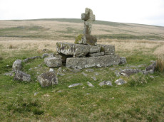
Notes: "A much disturbed cairn, 9m in diameter and 0.3m high with a modern 'kerb' of blocks and slabs, 5.8m in diameter and 0.5m high, set upon the mound. At the centre is a well built cist 1.4m long, 0.5m wide and 0.6m deep. Over this is a two tier pedestal of eight well trimmed blocks, of three different lengths; a further half buried block lies S of the monument. Upon this is a replacement socket stone and cross, cut at Holne in 1885". Lethbridge diagram p.93, photo p.94. Butler Vol. 4. Map 64.4 (diagram p.220). Breton p.22-23
Nearest Bus Stop: Princetown Dartmoor Visitor Centre (4.8 km) [Route: 98,171,172]
Nearby sites: SX 62577 70299
Down Tor N.E. (Eastern) Platform Cairn Circle and Cist
OS Map: SX 58397 69562
HER: MDV3499
Megalithic Portal: 52347
PMD: Down Tor N 3
Alternate name: Hingston Hill N.3 Platform Cairn Circle and Cist
Short Name: CT DownTorNE E
Butler map: 47.13.3
Dixon Cist #: 109
Grinsell: WAL 29
Turner: E34
DPD: 27
Barrow Report: 73
Dimensions (m): 4.2 x 0.6 C
Notes: Butler Hingston Hill N. 3. - Vol. 3. Map 47.13.3 (diagram p.73 OS SX58396955). Grinsell WALKHAMPTON 29 (OS 58276949 approx - same as HER MDV3499). Lethbridge p.27 Cist No.1.
Copyright for photos and plans from Barrow Reports 71-73 belongs to the Dixon estate. Reproduced here with kind permission.
Nearest Bus Stop: Princetown Dartmoor Visitor Centre (4.0 km) [Route: 98,171,172]
Nearby sites: SX 58397 69562
Drizzlecombe Platform Cairn Circle
Prehistoric Dartmoor Walks: Dartmoor Site: Drizzlecombe Ceremonial Complex (Photos 1)
OS Map: SX 59135 67134
HER: MDV3374
Megalithic Portal: 16932
PMD: Drizzlecombe N 14
Alternate name: Drizzlecombe 14 Platform Cairn Circle
Short Name: PC Drizzle 14
Butler map: 49.19.14
Grinsell: SHE 25a
Turner: E35
Barrow Report: 34 56
Dimensions (m): 3.5 x 0.2
Notes: "stone circle" marked on os 6" 1906. This site was almost totally excavated in 1914. Half an 11 foot diameter kerb circle and the slight remains of a cairn were found.3 flint flakes and a "well finished" scraper were found. The 34th Barrow Report includes a photo of the flints and the excavated and exposed kerb.
Nearest Bus Stop: Meavy Primary School (4.7 km) [Route: 56]
Nearby sites: SX 59135 67134
Willings Walls Warren Platform Cairn Circle and Cist
OS Map: SX 58279 65240
HER: MDV4021
Megalithic Portal: 45711
PMD: Willings Walls Warren S.
Alternate name: Willings Walls 2 Platform Cairn Circle and Cist
Short Name: CT Willings 2
Butler map: 51.6.2
Dixon Cist #: 48
Grinsell: SHA 25
Turner: E36
DPD: 53
Barrow Report: 51
Dimensions (m): 4.0 x 0.2 C
Notes: "Remains of a kerbed cairn with cist On a slight NW slope near a reave. The cairn is 4.6m in diameter and 0.6m high. Within the outer ring of stones is a second ring of boulders not shown on Worth's plan but which may represent an inner kerb. The cist is 1.8m by 0.9m and 0.5m deep with an adjacent coverstone." Lethbridge p.52-3 Willingswalls Cist 2 (E of Reave) - diagram p52, photo p.53. Butler Willings Walls 2 - Vol. 3. Map 51.6 (diagram p.165).
Nearest Bus Stop: Lee Moor Clearview (3.5 km) [Route: 59]
Nearby sites: SX 58279 65240
Dunnabridge Common Platform Cairn Circle and Cist
Prehistoric Dartmoor Walks: Dartmoor Site: Lakehead Hill
OS Map: SX 63585 75470
HER: MDV5952
Megalithic Portal: 37603
PMD: Smith Hill
Alternate name: Bellever Tor 9 Platform Cairn Circle and Cist
Short Name: CT Bellever 9
Butler map: 27.20.9
Dixon Cist #: 81
Grinsell: LYD 65
Turner: E37
DPD: 120
Barrow Report: 58
Dimensions (m): 1.2 x 0.4 C
Notes: Lethbridge Cist 3 diagram p.119 and photo bottom p.120. Butler Bellever Tor (Cairn 9) - Vol. 2. Map 27.20.9 (diagram p52-3). See also: Dartmoor Explorations: Antiquities of Black Newtake and Environs
Nearest Bus Stop: Powder Mills (1.3 km) [Route: 171]
Nearby sites: SX 63585 75470

Gutter Tor N. Platform Cairn Circle and Cist
OS Map: SX 57676 67137
HER: MDV4015
Megalithic Portal: 17511
PMD: Gutter Tor N.
Alternate name: Gutter Tor 3 Platform Cairn Circle and Cist
Short Name: CT GutterTor 3
Butler map: 49.5.3
Dixon Cist #: 86
Grinsell: SHE 9
Turner: E38
DPD: 33
Barrow Report: 59
Dimensions (m): 4.0 x 0.3 C
Notes: "A cairn with cist and a double circle of stones situated on the north-facing slope of Gutter Tor at about 305m OD. The end-stones and side-stones of the cist are in situ but the coverstone is missing." Lethbridge p.32-33 Cist A. Duplicated by HER 4045.Note Garmin NGR. (Previously listed as Gutter Tor No.2)Butler Gutter Tor 3 - Vol. 3. Map 49.5 (diagram p.118 "North cairn and cist").
Nearest Bus Stop: Meavy Primary School (3.3 km) [Route: 56]
Nearby sites: SX 57676 67137
Crow Tor Platform Cairn Circle and Cist
OS Map: SX 60531 78683
HER: MDV5938
Megalithic Portal: 45775
PMD: Crow Tor
Short Name: CT Crow Tor
Butler map: 29.18
Butler Vol 5: p.196 & Fig.139
Dixon Cist #: 115
Grinsell: LYD 41
Turner: E39
DPD: 109
Dimensions (m): 4.0 x 0.4
Notes: "A kerbed cairn and cist. The cairn consists of a stony, turf-covered mound, and measures 4.5m in diameter and 0.45m in height. There are traces of a retaining kerb of leaning, granite slabs to the northeast and south. The cist is set slightly to the north of the centre of the cairn. It is trapezoidal in shape, and measures 0.65m and 0.95m in length, 0.8m in width, and 0.5m in depth. The cover-stone, which is 0.9m long, 0.5m wide and 0.2m thick, is displaced and lies just to the south east of the cist." Lethbridge diagram p.107, photo bottom p.109. Butler Vol. 2. Map 29.18 (p.63, photo on p.124, diagram Vol. 5. p.196).
Nearest Bus Stop: Powder Mills (3.2 km) [Route: 171]
Nearby sites: SX 60531 78683
Trowlesworthy Warren Platform Cairn Circle and Cist
Prehistoric Dartmoor Walks: Dartmoor Site: Trowlesworthy, Settlements, Stone Row & Cairn Circle
OS Map: SX 57146 64757
HER: MDV28570
Megalithic Portal: 45773
PMD: Trowlesworthy Warren
Short Name: CT Trowles
Butler map: 51.1
Dixon Cist #: 112
Grinsell: SHA 30a
Turner: E40
DPD: 55
Dimensions (m): 4.0 x 0.2 C
Notes: "A round cairn and cist, located 370 metres east of Trowlesworthy Warren House. The cairn mound measures 5.2 metres in diameter and stands up to 0.1 metres high. Its perimeter is defined by a kerb of at least eight stones." One side stone is missing, capstone present. Lethbridge p.54-5 Trowlesworthy Farm Cist - diagram p.54, photo p.55. Butler Vol. 3. Map 51.1 (diagram p.158).
Nearest Bus Stop: Lee Moor Clearview (2.9 km) [Route: 59]
Nearby sites: SX 57146 64757
Sharpitor (N) or Peek Hill Platform Cairn Circle and Cist
Prehistoric Dartmoor Walks: Dartmoor Walk: Sharpitor area Stone Rows and Cists
OS Map: SX 55839 70693
HER: MDV3769
Megalithic Portal: 1246
PMD: Peek Hill
Alternate name: Sharpitor N. Platform Cairn Circle and Cist
Short Name: CT Peek Hill
Butler map: 45.12
Dixon Cist #: 103
Grinsell: WAL 21
Turner: E41
DPD: 22
Barrow Report: 72
Dimensions (m): 4.0 x 0.2 C
Notes: Bar Rep. 72 (TDA Vol 88 p.222). Butler Sharpitor N. - Vol. 3. Map 45.12 (diagram p.45 & photo p.84).
Copyright for photos and plans from Barrow Reports 71-73 belong to the Dixon estate. Reproduced here with kind permission.
Nearest Bus Stop: Walkhampton Memorial (2.7 km) [Route: 55,56]
Nearby sites: SX 55839 70693
Legis Tor, East Platform Cairn Circle and Cist
OS Map: SX 57474 65542
HER: MDV3424
Megalithic Portal: 45857
PMD: Legis Tor E.
Alternate name: Legis Tor E.1 Platform Cairn Circle and Cist
Short Name: CT LegisTor E1
Butler map: 49.2.1
Dixon Cist #: 49
Grinsell: SHE 23
Turner: E42
DPD: 38
Barrow Report: 51
Dimensions (m): 3.5 x 0.3 C
Notes: Butler Legis Tor E - Vol. 3. Map 49.2.1 (diagram p.113). Lethbridge p.37-38 Diagram p.37 Cist B.
Nearest Bus Stop: Meavy Primary School (3.5 km) [Route: 56]
Nearby sites: SX 57474 65542
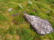
Legis Tor, West Platform Cairn Circle and Cist
OS Map: SX 57394 65481
HER: MDV3365
Megalithic Portal: 34130
PMD: Legis Tor W.
Alternate name: Legis Tor E.2 Platform Cairn Circle and Cist
Short Name: CT LegisTor E2
Butler map: 49.2.2
Dixon Cist #: 10
Grinsell: SHE 22
Turner: E43
DPD: 37
Barrow Report: 12 20 51
Dimensions (m): 4.0 x 0.3 C
Notes: Lethbridge p.37 Cist A. The photo is thought to be the capstone of this cist. Butler Legis Tor E. 2 - Vol. 3. Map 49.2 (diagram p.114).
Nearest Bus Stop: Meavy Primary School (3.4 km) [Route: 56]
Nearby sites: SX 57394 65481
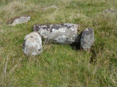
Deadmans Bottom D Platform Cairn Circle and Cist
Prehistoric Dartmoor Walks: Dartmoor Site: Guide to the Langcombe Brook & Deadman's Bottom Cists
OS Map: SX 6096 6673
HER: MDV5086
Megalithic Portal: 45731
PMD: Deadman's Bottom S 10
Alternate name: Langcombe Brook 10 Platform Cairn Circle and Cist
Short Name: CT:Deadmans D
Butler map: 50.3.10
Dixon Cist #: 55
Grinsell: SHA 10
Turner: E44
DPD: 45
Barrow Report: 53
Dimensions (m): 0.8 x 0.7 C
Notes: "The cairn is 5m in diameter by 0.3m high with a retaining kerb on its northern side. The cist is 0.8m long b 0.7m wide." "Cist (listed as 'D' by Worth) found at Deadman's Bottom Langcombe, by Mr Button. Internal dimensions, length 3 feet 8 inches, width 2 feet. The stones are barely visible above grass level. The cover stone is missing." Lethbridge p.45 Langcombe Cist E - diagram p.43. Butler Langcombe Brook Cairn 10 - Vol. 3. Map 50.3 (pp.148-54 general plan of Langcombe Brook cairns p.151, diagram of Langcombe cists p.153).
Nearest Bus Stop: Lee Moor Clearview (6.1 km) [Route: 59]
Nearby sites: SX 6096 6673
Hentor Farm Platform Cairn Circle and Cist
Prehistoric Dartmoor Walks: Dartmoor Site: Guide to the Hentor & Shavercombe Brook Cists
OS Map: SX 59089 65792
HER: MDV12744
Megalithic Portal: 45774
PMD: Hen Tor Meadow
Short Name: CT Hentor Farm
Dixon Cist #: 114
Grinsell: SHA 48
Turner: E45
Dimensions (m): 3 x 0.15
Notes: "A slight cairn with retaining circle, enclosing a cist aligned SSE-NNW, near the junction of Shavercombe Lake and River Plym." Turner has "central cist". Not listed by Butler (relevant map Vol. 3. Map 49.22).
Nearest Bus Stop: Lee Moor Clearview (4.3 km) [Route: 59]
Nearby sites: SX 59089 65792
Hentor Warren (Shavercombe) Platform Cairn Circle and Cist
Prehistoric Dartmoor Walks: Dartmoor Site: Guide to the Hentor & Shavercombe Brook Cists
OS Map: SX 59632 65777
HER: MDV3492
Megalithic Portal: 45662
PMD: Hen Tor Warren 4
Alternate name: Hen Tor N.4 Platform Cairn Circle and Cist
Short Name: CT Hen Tor N 4
Butler map: 49.22.4
Dixon Cist #: 12
Grinsell: SHA 29
Turner: E47
DPD: 50
Barrow Report: 12 20
Dimensions (m): 4.0 x 0.4 C
Notes: "On the slope north of Hen Tor at 395.0m OD is the remains of a cairn with a cist. The cairn measures 5.6m in diameter and 0.6m in height with a few stones of a cairn circle 3.2m in diameter remaining on the west side. The cist is 1.2m by 0.4m and 0.5m deep with a coverstone 1.6m by 1.1m at its maximum." Lethbridge p.50 Shavercombe Cist C - diagram p.49. Butler Hen Tor Cairn 4- Vol. 3. Map 49.22 (general plan of Hen Tor with diagram of cists pp.146-7).
Nearest Bus Stop: Lee Moor Clearview (4.6 km) [Route: 59]
Nearby sites: SX 59632 65777
Hentor (Shavercombe) Platform Cairn Circle and Cist
Prehistoric Dartmoor Walks: Dartmoor Site: Guide to the Hentor & Shavercombe Brook Cists
OS Map: SX 59372 65801
HER: MDV3479
Megalithic Portal: 45661
PMD: Hen Tor Warren 2
Alternate name: Hen Tor N.2 Platform Cairn Circle and Cist
Short Name: CT Hen Tor N 2
Butler map: 49.22.2
Dixon Cist #: 11
Grinsell: SHA 26
Turner: E48
DPD: 50
Barrow Report: 20
Dimensions (m): 5.0 x 0.4 C
Notes: "A cairn with circle and cist. The cairn is 5m in diameter and 0.4m high and contains at least six upright stones forming a circle that surrounds the centrally placed cist. The cist, in fair condition, is aligned north west/south east. A flat stone lying immediately south west of the cist may be the capstone." Lethbridge p.50-51 Shavercombe Cist E - diagram p.49. Shavercombe. Butler Hen Tor Cairn 2 - Vol. 3. Map 49.22 (general plan of Hen Tor with diagram of cists pp.146-7).
Nearest Bus Stop: Lee Moor Clearview (4.5 km) [Route: 59]
Nearby sites: SX 59372 65801
Archerton Tennis Ground Platform Cairn Circle and Cist
OS Map: SX 63852 78872
HER: MDV5839
Megalithic Portal: 37599
PMD: Archerton Tennis Court
Alternate name: Archerton Platform Cairn Circle and Cist
Short Name: CT Arch Tennis
Butler map: 27.18
Dixon Cist #: 74
Grinsell: LYD 45
Turner: E49
DPD: 114
Barrow Report: 57
Dimensions (m): 0.95 x 0.85 C
Notes: Lethbridge diagram p.112, photo top p.114. Butler Archerton - Vol. 2. Map 27.18. Breton p.37 Its four sides are complete, the capstone is partially buried; it stands on a slight mound and has been enclosed by a circle of small stones which are nearly buried under the turf.
Nearest Bus Stop: Postbridge Post Office (0.9 km) [Route: 98,171]
Nearby sites: SX 63852 78872

East Glazebrook Platform Cairn Circle
Prehistoric Dartmoor Walks: Dartmoor Walk: The Neolithic tombs of Cuckoo Ball & Corringdon Ball
OS Map: SX 66623 61237
HER: MDV15960
Megalithic Portal: 808
Alternate name: Corringdon Ball 6 Platform Cairn Circle
Short Name: PC Corringdo6
Butler map: 56.8.6
Grinsell: UGB 3a
Turner: E50
Barrow Report: 68
Dimensions (m): 14.0 x 0.4
Notes: Platform Cairn with Outer Stone Circles. "A ruined cairn with a very stony centre and the remains of multiple concentric rings of small stones visible on the south side. A substantial bank survives on the north side." Lethbridge p.82
Nearest Bus Stop: South Brent Pool Park (3.8 km) [Route: 38]
Nearby sites: SX 66623 61237

Yar Tor (Money Pit) Platform Cairn Circle and Cist
OS Map: SX 68181 73865
HER: MDV6460
Megalithic Portal: 1369
PMD: Money Pit
Alternate name: Money Pit Platform Cairn Circle and Cist
Short Name: CT Money Pit
Butler map: 14.11
Butler Vol 5: p.23 & Fig.4
Dixon Cist #: 69
Grinsell: WID 21
Turner: E51
DPD: 122
Barrow Report: 56 62
Dimensions (m): c3.2 cist 1.0 x 0.4
Notes: "The south cairn is a very spread and slight earthwork with a centrally placed cist. Only the north and west side slabs of the cist remain in situ though a misplaced slab lies to one side of the chamber. Eleven slabs forming a kerb of approximately 3m surrounding the cist remain in situ. Several additional stones survive, protruding just above the surface of the flattened cairn, which are likely to be evidence of an outer circle with a diameter of approximately 11m". Lethbridge diagram p.122 and photo bottom p.122. Butler Money Pit - Vol. 1. Map 14.11 (photo on p.92, diagram pp.125-6).
Nearest Bus Stop: Dartmeet Badgers Holt (1.1 km) [Route: 172]
Nearby sites: SX 68181 73865
Eastern beacon (S) Platform Cairn Circle
OS Map: SX 66755 58770
HER: MDV3106
Megalithic Portal: 17583
Alternate name: Ugborough Beacon 4 Platform Cairn Circle
Short Name: PC Ugborough 4
Butler map: 53.16.6
Grinsell: UGB 20
Turner: E52
Barrow Report: 62
Dimensions (m): 20.0 x 2.2
Notes: Flat top turf-covered cairn. 20.5m. diameter, 1.7m. high. Possible remains of retaining circle. Large hollow in centre
Nearest Bus Stop: South Brent Pool Park (3.6 km) [Route: 38]
Nearby sites: SX 66755 58770
Shell Top Platform Cairn Circle
OS Map: SX 59766 63805
HER: MDV12905
Megalithic Portal: 45646
PMD: Shell Top
Alternate name: Shell Top Summit 1 Platform Cairn Circle
Short Name: PC:ShellTopSu1
Butler map: 51.10.1
Grinsell: COR 1
Turner: E53
Dimensions (m): 16.0 x 2.0
Notes: Cairn 9.5m in diameter with boulder of tor. Butler Vol 3 map 51.10 p.174.
Nearest Bus Stop: Lee Moor Clearview (3.2 km) [Route: 59]
Nearby sites: SX 59766 63805
Shell Top Summit 2 Platform Cairn Circle
OS Map: SX 59902 63740
HER: MDV12791
Short Name: CN:ShellTopSu2
Butler map: 51.10.2
Butler Vol 5: p.194 & Fig.138
Grinsell: COR 1b
Turner: E55
Dimensions (m): 11.0 x 0.4
Nearest Bus Stop: Lee Moor Clearview (3.2 km) [Route: 59]
Nearby sites: SX 59902 63740
Page last updated 12/07/15