
The Turner Classification of Cairns
Turner used the following clasifications for stone circles and cairns:
Listing of Turner Cairns: F Encircled Cairn
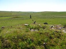
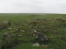
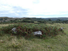
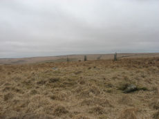
Drizzlecombe S Row Encircled Cairn
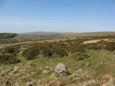
Prehistoric Dartmoor Walks: Dartmoor Site: Drizzlecombe Ceremonial Complex (Photos 1)
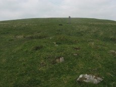
OS Map: SX 59170 66964
HER: MDV14779
Megalithic Portal: 16937
PMD: Drizzlecombe SW Row
Alternate name: Drizzlecombe stone row 1 Encircled Cairn
Short Name: EC Drizzle S
Butler map: 49.19.1
Grinsell: SHE 32
Dimensions (m): 7.0 x 0.8
Notes: "Cairn lies at the north-east end of Row A (South Row)of the Drizzlecombe group. Cairn measures 6.7 metres in diameter, up to 0.8 metres high, with central hollow 2.3 metres by 1.5 metres by 0.25 metres deep." "Small number of edge stones around the periphery represent a kerb. Large flat stone, 1.7m by 1m by 0.3m thick, situated immediately s of the mound may be the displaced coverstone from a cist"
Nearest Bus Stop: Meavy Primary School (4.8 km) [Route: 56]
Nearby sites: SX 59170 66964
Cosdon Hill Encircled Cairn
OS Map: SX 63350 92479
HER: MDV13064
Megalithic Portal: 22695
Alternate name: Cosdon Hill N.4 Encircled Cairn
Short Name: EC Cosdon N4
Butler map: 40.9
Grinsell: ST 10
Dimensions (m): c.7.0 x 0.4
Notes: Cairn at the junction of two Bronze Age reaves. "Round cairn on Cosdon Hill, measuring 7.3 metres in diameter and standing up to 0.8 metres high. A number of edge set stones visible around the southern side of the cairn mound suggests the existence of a kerb. There is a hollow in the north side of the mound, probably the result of partial robbing or an early excavation."
Nearest Bus Stop: Ramsley (1.7 km) [Route: 670,671,6A]
Nearby sites: SX 63350 92479
Seven Lords' Lands Encircled Cairn
OS Map: SX 74127 76237
HER: MDV7396
Megalithic Portal: 3454
PMD: Seven Lord's Lands
Alternate name: Sevon Lords Lands Encircled Cairn
Short Name: EC 7LordsLands
Butler map: 9.10
Butler Vol 5: p.51 & Fig.29
Grinsell: WID 13
Turner: F1
Barrow Report: 53
Dimensions (m): 10.0 x 0.6
Notes: A cairn from 0.8m. to 1.2m. high, with a minor central excavation 0.5m. deep. The kerb retaining circle extends round the west and north quadrants.
Nearest Bus Stop (Minor): Widecombe in the Moor Car Park (2.3 km) [Route: 271]
Nearest Bus Stop (Major): Poundsgate Tavistock Inn (5.5 km) [Route: 172]
Nearby sites: SX 74127 76237
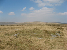
Corn Ridge Encircled Cairn
OS Map: SX 55175 89119
HER: MDV3171
Megalithic Portal: 3158
Alternate name: Branscombe's Loaf 1 Encircled Cairn
Short Name: EC Branscomb 1
Butler map: 43.12.1
Grinsell: BRI 9
Turner: F2
Dimensions (m): 15.5 x 1.8
Notes: One of 4 cairns on Corn Ridge - see Turner "Ring Cairns, Stone Circles and Related Monuments on Dartmoor" DASP No. 48 p59 for diagram of the 4 cairns.
Nearest Bus Stop: Sourton Windard Terrace (2.1 km) [Route: 118]
Nearby sites: SX 55175 89119
Harford Gate Encircled Cairn
Prehistoric Dartmoor Walks: Dartmoor Walk: The Neolithic tombs of Cuckoo Ball & Corringdon Ball
OS Map: SX 64494 59677
HER: MDV13092
Megalithic Portal: 3281
Alternate name: Piles Hill S.W.9 Encircled Cairn
Short Name: EC HarfordGate
Butler map: 53.11.9
Grinsell: HAR 26
Turner: F3
Dimensions (m): 6.5 x 0.3
Notes: "This cairn occupies a prominent position on the brow of a hill and is one of two north-west of Harford Moor Gate. Measures 13 metres in diameter and 0.3 metres in height, it is turf-covered and has a retaining kerb." Visited by the author 20/04/19. Garmin gives location as SX 64495 59682 but a Lidar source gives location as SX 64494 59677 - which matches closely the HER NGR.
Nearest Bus Stop: Ivybridge BP Garage (Stop B) (3.7 km) [Route: 38]
Nearby sites: SX 64494 59677
Fernworthy E. Encircled Cairn
Prehistoric Dartmoor Walks: Dartmoor Site: Fernworthy Ceremonial Complex
OS Map: SX 65561 84090
HER: MDV6560
Megalithic Portal: 3234
Alternate name: Fernworthy 5 Encircled Cairn
Short Name: EC:Fernworth 5
Butler map: 35.15.5
Grinsell: LYD 24
Turner: F4
DPD: 138
Dimensions (m): c.6.0 x 0.6
Notes: Newman Barrow D. "5.8m diameter. Has 3 stones spaced on the east side. A beaker, flint knife, dress fastener and a piece of bronze were discovered when the cairn was excavated in 1898". The crushed beaker. When reconstructed it became one of Dartmoor's most important Bronze Age finds and is now on display in Plymouth City Museum along with the other artifacts retrieved. DNP Post 7D.
Nearest Bus Stop: Warren House Inn (3.7 km) [Route: 171]
Nearby sites: SX 65561 84090
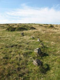
Ringmoor Down Encircled Cairn
OS Map: SX 56334 65807
HER: MDV3987
Megalithic Portal: 1233
PMD: Ringmoor Down Stone Row
Alternate name: Ringmoor Down stone row Encircled Cairn
Short Name: EC Ringmoor S
Butler map: 49.20
Grinsell: SHE 19
Turner: F5
DPD: 35
Dimensions (m): 12.7 x 0.1
Notes: "The cairn circle measures approximately 12.6m. in diameter and has eleven stones averaging 0.7m. high. The disturbed central cairn is 9.5m. in diameter and 0.4m. in height." "1909 the circle was restored and five of the present stones were introduced from elsewhere. Prior to restoration one stone was standing, four had fallen and the presumed sites of six other stones were represented by pits." Lethbridge Brisworthy cairn circle p.34-35. Diagram p. 34 site 2.
Nearest Bus Stop: Meavy Primary School (2.3 km) [Route: 56]
Nearby sites: SX 56334 65807
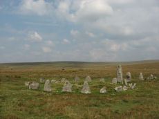
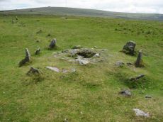
Hingston Hill (Down Tor) Encircled Cairn
Prehistoric Dartmoor Walks: Dartmoor Site: Down Tor Stone Row and Cairn Circle
OS Map: SX 58693 69270
HER: MDV3439
Megalithic Portal: 541
PMD: Down Tor Cairn Circle
Alternate name: Hingston Hill stone row Encircled Cairn
Short Name: EC Down Tor
Butler map: 47.12
Grinsell: WAL 31
Turner: F6
DPD: 28
Barrow Report: 14
Dimensions (m): 12.0 x 0.5 C?
Notes: "The cairn circle consists of 26 upright stones and possibly two more now recumbent; it has an internal diameter of 11.5m. Within the circle is a cairn of 8.5m diameter and 0.6m height with a small depression in the centre which may be the site of a cist". Lethbridge pp.27-29, diagram p.27.
Nearest Bus Stop: Princetown Dartmoor Visitor Centre (4.3 km) [Route: 98,171,172]
Nearby sites: SX 58693 69270
Drizzlecombe E. Encircled Cairn
Prehistoric Dartmoor Walks: Dartmoor Site: Drizzlecombe Ceremonial Complex (Photos 1)
OS Map: SX 59267 67065
HER: MDV4047
Megalithic Portal: 3207
PMD: Drizzlecombe C
Alternate name: Drizzlecombe stone row 2 Encircled Cairn
Short Name: EC Drizzle E
Butler map: 49.19.2
Grinsell: SHE 30
Turner: F7
DPD: 39
Dimensions (m): 9.2 x 1.0
Notes: Eastern most in alignment of 3 cairns. Cairn heads the NE Drizzlecombe row. See diagram in coverage on Prehistoric Dartmoor Walks, marked as C2. Lethbridge Row B. pp.38-42. Diagram p.38. See also 14780
Nearest Bus Stop: Meavy Primary School (4.8 km) [Route: 56]
Nearby sites: SX 59267 67065
Butterdon Hill Encircled Cairn
Prehistoric Dartmoor Walks: Dartmoor Walk: The Erme East stone rows
OS Map: SX 65634 58816
HER: MDV2897
Megalithic Portal: 722
PMD: Butterdon Row
Alternate name: Butterdon Hill stone row Encircled Cairn
Short Name: EC Butterdon 1
Butler map: 53.8.1
Grinsell: HAR 16
Turner: F8
DPD: 78
Dimensions (m): c.11.0 x 0.6
Notes: A low cairn within a retaining circle of stones is situated at SX65635881, at the south end of the Butterdon stone row (SX 65 NE 17), with which it is associated. The circle is 11 metres in diameter, and consists of twelve stones, all now recumbent, although when Worth wrote in 1941, one was erect and three were leaning. Some of the stones are unusually large. The cairn is 9 metres in diameter by 0.3 metre high, with a hollow in the centre. Radcliffe reports: Mike Brown says the row "terminates in a small kistvaen" at its southern end. Hemery says the cist "has been removed". Lethbridge p.78 Row 1 diagram p.77.
Nearest Bus Stop: Ivybridge BP Garage (Stop B) (3.3 km) [Route: 38]
Nearby sites: SX 65634 58816
Spurrells Cross Encircled Cairn
Prehistoric Dartmoor Walks: Dartmoor Walk: The Erme East stone rows
OS Map: SX 65858 59864
HER: MDV2891
Megalithic Portal: 1273
PMD: Spurrell's Cross Stone Row
Alternate name: Spurrell's cross stone row Encircled Cairn
Short Name: EC:Spurrells X
Butler map: 53.10
Grinsell: UGB 12
Turner: F9
Barrow Report: 56
Dimensions (m): 10.5 x 0.3
Notes: Cairn at SX 65855985, 12 metres in diameter by 0.4 metres high, with two stones of retaining circle, from which double stone row descends to north north west. This cairn is located about 125 metres from Spurrells Cross.
Nearest Bus Stop: Ivybridge BP Garage (Stop B) (4.3 km) [Route: 38]
Nearby sites: SX 65858 59864
Burford Down Encircled Cairn
Prehistoric Dartmoor Walks: Dartmoor Site: Burford Down stone row and cairns
OS Map: SX 63704 60178
HER: MDV4257
Megalithic Portal: 719
PMD: Burford Down Stone Row
Alternate name: Burford Down stone row Encircled Cairn
Short Name: EC BurfordDown
Butler map: 54.17
Grinsell: HAR 5
Turner: F10
DPD: 70
Barrow Report: 14 40
Dimensions (m): 9.5 x 0.3
Notes: "The south terminal cairn, 9.0m diameter and 0.6m high, has a central depression, about 2.5m diameter and 0.4m deep, and is edged by 3 upright and 2 fallen orthostats, average 0.7m by 0.2m and up to 0.9m high, the remains of a retaining circle or peristalith."
Nearest Bus Stop: Cornwood Crossways (3.3 km) [Route: 59]
Nearby sites: SX 63704 60178
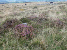
Brown Heath (Hook Lake) Encircled Cairn and Cist
OS Map: SX 64114 65327
HER: MDV5137
Megalithic Portal: 52166
The Stone Rows of GB: Hook Lake
PMD: Hook Lake Stone row
Alternate name: Hook Lake stone row Encircled Cairn and Cist
Short Name: CT Hook Lake
Butler map: 55.8
Dixon Cist #: 40
Grinsell: HAR 3
Turner: F11
DPD: 74
Barrow Report: 38
Dimensions (m): 9.2 x 0.8 C
Notes: "A double stone row, on Brown Heath, circa 540 feet in length, direction of length N 10o E. At the north end is a stone circle, diameter 31 feet, surrounding a cairn which contains the remains of a cist." Ruined and possibly no longer visible. Butler Hook Lake stone row - Vol. 4. Map 55.8 (pp.78-9).
Nearest Bus Stop: Cornwood Crossways (6.8 km) [Route: 59]
Nearby sites: SX 64114 65327

Hart Tor North Encircled Cairn
Prehistoric Dartmoor Walks: Dartmoor Site: Hart Tor Stone Row & Cairn Circle
OS Map: SX 57718 71716
HER: MDV49460
Megalithic Portal: 978
PMD: Harter N Stone Row
Alternate name: Hart Tor double stone row Encircled Cairn
Short Name: EC Hart Tor N
Butler map: 46.5
Butler Vol 5: p.39 & Fig.16
Grinsell: WAL 12
Turner: F12
DPD: 25
Dimensions (m): 9.3 x 0.8
Notes: The cairn circle is 9.3m across and consists of 14 tall slabs some of which have fallen. Wilkinson noticed concentric stone circles - which can't be seen today although there is clearly an inner circular mound. NMR A.
Nearest Bus Stop: Princetown Dartmoor Visitor Centre (2.2 km) [Route: 98,171,172]
Nearby sites: SX 57718 71716
Drizzlecombe (Central) Encircled Cairn
Prehistoric Dartmoor Walks: Dartmoor Site: Drizzlecombe Ceremonial Complex (Photos 1)
OS Map: SX 59253 67081
HER: MDV14772
Megalithic Portal: 3206
PMD: Drizzlecombe B
Alternate name: Drizzlecombe stone row 3 Encircled Cairn
Short Name: EC Drizzle Ce
Butler map: 49.19.3
Grinsell: SHE 29
Turner: F13
Barrow Report: 56
Dimensions (m): 8.6 x 1.0
Notes: Central in alignment of 3 cairns. Cairn heads the NW Drizzlecombe row. See diagram in coverage on Prehistoric Dartmoor Walks, marked as C3.
Nearest Bus Stop: Meavy Primary School (4.8 km) [Route: 56]
Nearby sites: SX 59253 67081
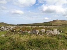
East Glazebrook Encircled Cairn
Prehistoric Dartmoor Walks: Dartmoor Site: Corringdon Ball Chambered Tomb & Stone Rows
OS Map: SX 66679 61215
HER: MDV129970
Megalithic Portal: 3160
PMD: Corringdon Ball C Stone Row
Alternate name: Corringdon Ball stone rows 1 Encircled Cairn
Short Name: EC East Glaze
Butler map: 56.8.1
Grinsell: UGB 4
Turner: F14
DPD: 82
Barrow Report: 66 68
Dimensions (m): 14.5
Notes: Cairn at east end of the Corringdon Ball group of multiple stone rows . Six pillars of the retaining circle are clearly visible. For more detail see entries for the Corringdon Ball rows.
Nearest Bus Stop: South Brent Pool Park (3.8 km) [Route: 38]
Nearby sites: SX 66679 61215
Legis Lake Encircled Cairn
OS Map: SX 56563 65513
HER: MDV3360
Megalithic Portal: 34135
Alternate name: Ringmoor Down 1 Encircled Cairn
Short Name: EC Ringmoor 1
Butler map: 49.21.1
Grinsell: SHE 21
Turner: F15
Barrow Report: 29 35
Dimensions (m): 10.0 x 0.3
Notes: "cairn with retaining circle of which 5 stones protrude and there are indications of others. Diameter 8.2m, height 0.2m. Excavated by r. H. Worth: just n of centre, a pit containing charcoal mixed with earth."
Nearest Bus Stop: Meavy Primary School (2.7 km) [Route: 56]
Nearby sites: SX 56563 65513
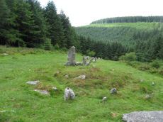
Assycombe Hill Encircled Cairn and Cist
Prehistoric Dartmoor Walks: Dartmoor Site: Assycombe Double Stone Row
OS Map: SX 66102 82650
HER: MDV6538
Megalithic Portal: 45814
PMD: Assycombe Stone Row
Alternate name: Assycombe Hill Stone Row Encircled Cairn and Cist
Short Name: CT Assycombe
Butler map: 35.19
Butler Vol 5: p.232 & Fig.164
Dixon Cist #: 157
Grinsell: LYD 26
Turner: F16
DPD: 135
Dimensions (m): 8.0 x 0.4 C
Notes: The cairn at the E end is in line with the N of the two rows. It measures 8.4m in diameter and is 0.6m high. It contains a large quantity of stone; two stones in the centre, set at right angles to each other around a hollow, suggest the remains of a cist. Breton p.68.
Nearest Bus Stop: Warren House Inn (2.2 km) [Route: 171]
Nearby sites: SX 66102 82650
Collard Tor Encircled Cairn
OS Map: SX 5584 6203
HER: MDV14793
Megalithic Portal: 794
PMD: Collard Tor
Alternate name: Collard Tor stone row 1 Encircled Cairn
Short Name: EC Collard Tor
Butler map: 48.6.1
Grinsell: SHA 46
Turner: F17
DPD: 57
Barrow Report: 22
Dimensions (m): 9.0 x 0.3 C?
Notes: Cairn heading the easterly of the two Collard Tor rows. "The easterly cairn at SX 55846203 measures 8.1m. in diameter and 0.6m. high. The centre has been excavated, but apart from a large prone slab there is nothing to suggest a former cist. The mound is surrounded by a peristalith of boulders each of which is 0.9m. high and roughly 0.5m square. The row is similar to the other row and can be traced for 79.6m."
Nearest Bus Stop: Wotter Methodist Church (0.2 km) [Route: 59]
Nearby sites: SX 5584 6203
Bellever Tor (SW) Encircled Cairn
OS Map: SX 64144 76275
HER: MDV5885
Megalithic Portal: 3056
Alternate name: Bellever Tor 2 Encircled Cairn
Short Name: EC:Bellever 2
Butler map: 27.20.2
Grinsell: LYD 59a
Turner: F18
Dimensions (m): 6.0 x 0.8
Notes: cairn, it does not appear to have been excavated, although there is a slight disturbance at the top centre where large granite stones are bared. At the north west extreme are two stones, the positions of which indicate this being part of the retaining circle, no others remain. Height 0.8m, diameter 5.0m. Turner F18. See also: Dartmoor Explorations: Antiquities of Black Newtake and Environs. NGR taken from Dartmoor Explorations (Steve Grigg).
Nearest Bus Stop: Powder Mills (1.3 km) [Route: 171]
Nearby sites: SX 64144 76275
Merivale (S) Encircled Cairn
OS Map: SX 55368 74602
HER: MDV3759
Megalithic Portal: 52014
The Stone Rows of GB: Merrivale 4
PMD: Merrivale Menhir
Alternate name: Merrivale 6 (near standing stone) Encircled Cairn
Short Name: EC Merrivale 6
Butler map: 44.8.6
Grinsell: WAL 6
Turner: F19
Dimensions (m): 3.0 x 0.2
Notes: The cairn now turf-covered with an excavation pit in the centre, has a diameter of 2.4m. and a height of 0.1m. The excavation pit can be seen in the photo. A very irregular "circle" of stones can be seen around this cairn. Turner F19.
Nearest Bus Stop: Merrivale Dartmoor Inn (0.8 km) [Route: 98,171,172]
Nearby sites: SX 55368 74602
Merrivale double row B (centre) Encircled Cairn and Cist
Prehistoric Dartmoor Walks: Dartmoor Walk: Merrivale Complex
OS Map: SX 55442 74779
HER: MDV14796
Megalithic Portal: 3389
PMD: Merrivale S row
Alternate name: Merrivale double row 2 centre Encircled Cairn and Cist
Short Name: CT Merrivale 2
Butler map: 44.8.2
Dixon Cist #: 142
Grinsell: WAL 4
Turner: F20
DPD: 17
Dimensions (m): 3.3 x 0.3 C
Notes: Butler Merrivale double row 2, (centre) - Vol. 3. Map 44.8.1 (diagram p.27). Lethbridge pp.16-18, diagram p.16.
Nearest Bus Stop: Merrivale Dartmoor Inn (0.7 km) [Route: 98,171,172]
Nearby sites: SX 55442 74779
Yellowmead Down Encircled Cairn
Prehistoric Dartmoor Walks: Dartmoor Site: Yellowmead 4-fold Cairn Circle
OS Map: SX 57535 67861
HER: MDV4025
Megalithic Portal: 31040
Alternate name: Yellowmead Down 1 Encircled Cairn
Short Name: EC Yellowmd 1
Butler map: 47.14.1
Grinsell: SHE 5
Turner: F21
DPD: 31
Barrow Report: 41
Dimensions (m): 3.5 x 0.2
Notes: Cairn around 50 meters north-east of the Yellowmead stone circles, consisting of an earth and stone mound approximately 4 meters in diameter and up to 0.3 meters high. Four stones of a retaining kerb on its west and south sides. Turner F21.
Nearest Bus Stop: Meavy Primary School (3.2 km) [Route: 56]
Nearby sites: SX 57535 67861
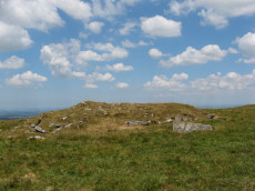
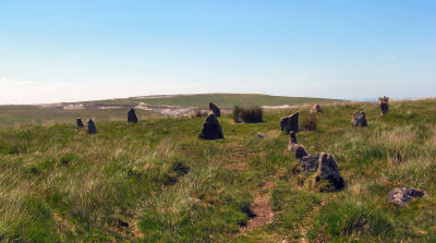
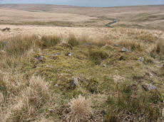
Stalldown Encircled Cairn
Prehistoric Dartmoor Walks: Dartmoor Site: Stalldown Stone Row [Photo Set 2]
OS Map: SX 63208 62489
HER: MDV4298
Megalithic Portal: 531
Alternate name: Stalldown Summit 3 Encircled Cairn
Short Name: EC Staldon 3
Butler map: 54.18.3
Grinsell: COR 19
Turner: F22
Dimensions (m): 14.5 x 0.5
Notes: Cairn with double or multiple ring. Butler Cairn 3 just to the west of the stone row, Butler Cairn 4 is just to the east. A flat topped turf-covered cairn 9.0m in diameter and 0.7m high, in good condition. Settings of Stones in and around the structure suggests a complex cairn circle. The author counted 17 stones in the circle around this cairn. This is difficult to see in the photo as most are concealed under vegetatio, the stone row can be seen in the background. Also visible towards the centre of the circle is a rectangular pit which is probably evidence of excavation. Turner F22, Type Fii
Nearest Bus Stop: Cornwood Crossways (4.0 km) [Route: 59]
Nearby sites: SX 63208 62489
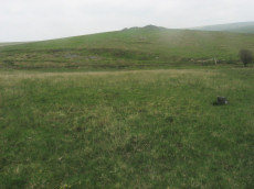
Brent Forehill Encircled Cairn
Prehistoric Dartmoor Walks: Dartmoor Walk: The Neolithic tombs of Cuckoo Ball & Corringdon Ball
OS Map: SX 66854 61356
HER: MDV13282
Megalithic Portal: 1777
PMD: Brent Fore Hill Stone Row
Alternate name: Brent Fore Hill stone row Encircled Cairn
Short Name: EC BrentForeSR
Butler map: 56.10
Grinsell: BRE 8
Turner: F23
Barrow Report: 66
Dimensions (m): 13.5 x 0.4
Notes: The remains of a stone row and cairn on Brent Fore Hill. The row is crossed by two leats, one of which is now disused. The cairn is visible as a low mound of turf-covered stones of 13.5 metres in diameter and 0.3 metres high. Photo shows 2 or 3 stones of the cairn - it is not very photogenic! Turner F23.
Nearest Bus Stop: South Brent Pool Park (3.6 km) [Route: 38]
Nearby sites: SX 66854 61356
Drizzlecombe (W) Encircled Cairn
Prehistoric Dartmoor Walks: Dartmoor Site: Drizzlecombe Ceremonial Complex (Photos 1)
OS Map: SX 59236 67101
HER: MDV3329
Megalithic Portal: 10499
PMD: Drizzlecombe N Row
Alternate name: Drizzlecombe 4 Encircled Cairn
Short Name: EC Drizzle W
Butler map: 49.19.4
Grinsell: SHE 28
Turner: F24
Dimensions (m): 8.8 x 0.9
Notes: Western most in alignment of 3 cairns. The other two cairns head Drizzlecombe rows. See diagram in coverage on Prehistoric Dartmoor Walks, marked as C4. Turner F24
Nearest Bus Stop: Meavy Primary School (4.8 km) [Route: 56]
Nearby sites: SX 59236 67101
Fernworthy (SW) Encircled Cairn
Prehistoric Dartmoor Walks: Dartmoor Site: Fernworthy Ceremonial Complex
OS Map: SX 65483 84101
HER: MDV14885
Megalithic Portal: 35827
Alternate name: Fernworthy 3 Encircled Cairn
Short Name: EC Fernworth 3
Butler map: 35.15.3
Butler Vol 5: p.36 & Fig.14
Grinsell: LYD 21
Turner: F25
Dimensions (m): 6.0 x 0.3
Notes: Newman Barrow A. Small turf-covered cairn at the northern end of the western double stone row south of Fernworthy stone circle forming part of the Froggymead ceremonial complex. It measures 6.5 metres in diameter and has a central hollow resulting from excavation in 1898. Two rings of orthostats, 7m and 5m diameter, around cairn 4.5m diameter and 0.2m high (Turner). It once had a retaining circle of small stones but only three were visible in 2013. DNP Post 2D. Turner F25.
Nearest Bus Stop: Warren House Inn (3.7 km) [Route: 171]
Nearby sites: SX 65483 84101
Page last updated 12/07/15