
The Turner Classification of Cairns
Turner used the following clasifications for stone circles and cairns:
Listing of Turner Cairns: D Ring Setting
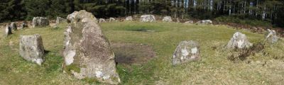
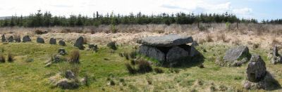
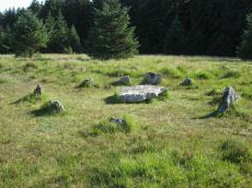
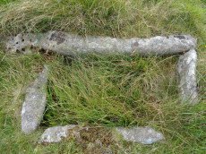
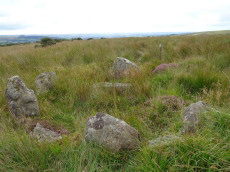
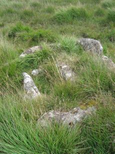
Soussons Common Ring Setting Cairn and Cist
Prehistoric Dartmoor Walks: Dartmoor Site: Soussons Cairn Circle
OS Map: SX 67516 78700
HER: MDV6013
Megalithic Portal: 1266
PMD: Soussons Plantation
Alternate name: Soussons Plantation S. Ring Setting Cairn and Cist
Short Name: CT Soussons Cm
Butler map: 24.2.6
Dixon Cist #: 16
Grinsell: MAN 9
Turner: D2
DPD: 124
Barrow Report: 22 23 45 56
Dimensions (m): 8.6 C
Notes: "A 28 feet diameter cairn circle with a central cist (plan). The tallest stone in the cairn circle is about 2 feet high." "This cist measures at least 1.3 metres long by 0.5 metres wide and when excavated in 1903 two coils of human hair were found". Lethbridge p.124. Butler Soussons Plantation S - Vol. 2. Map 24.2.6 (diagrams pp. 18-20). Breton p.41.
Nearest Bus Stop: Warren House Inn (2.3 km) [Route: 171]
Nearby sites: SX 67516 78700
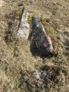
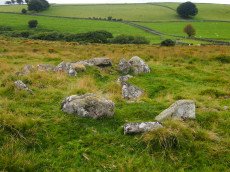
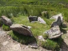
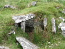
Brockhill Ford Ring Setting Cairn and Cist
OS Map: SX 67809 65702
HER: MDV5234
Megalithic Portal: 705
PMD: Brockhill Ford
Alternate name: Brockhill Ford W. Ring Setting Cairn and Cist
Short Name: CT Brockhill
Butler map: 57.18
Dixon Cist #: 101
Grinsell: DEA 2
Turner: D3
DPD: 88
Barrow Report: 68
Dimensions (m): 7.5 x 0 C
Notes: "The side stones, both 1.4m long, lean inwards and the end stones north west 0.7m long, southeast 0.8m long, are firmly set. The probable coverstone, 1.2m by 0.8m, is displaced and lies to the south east of the cist. The cist is surrounded by the remains of a stone circle, long axis 8.8m, aligned with cist, short axis 7.2m. It is constructed of large slabs, up to 1.4m long with a single upright stone, 0.5m high, set contiguously in the north west arc. There are no visible remains of a cairn." Lethbridge p.88 photo (note the diagram is not related). See also: Huntingdon cross walk. Butler Brockhill Ford W. - Vol. 4. Map 57.18 (pp.151-2 diagram p.152).
Nearest Bus Stop: Buckfast Higher Mill Lane (6.3 km) [Route: 88]
Nearby sites: SX 67809 65702
Black Newtake (C) No. 3 Ring Setting Cairn and Cist
Prehistoric Dartmoor Walks: Dartmoor Site: Lakehead Hill
OS Map: SX 63893 75869
HER: MDV5890
Megalithic Portal: 34908
PMD: Black Newtake Central
Alternate name: Bellever Tor 6 Ring Setting Cairn and Cist
Short Name: CT Bellever 6
Butler map: 27.20.6
Dixon Cist #: 79
Grinsell: LYD 62
Turner: D4
DPD: 120
Barrow Report: 57
Dimensions (m): 7.4 x level C
Notes: Further coverage on Lakehead Hill page. Lethbridge diagram p.119 Cist 2 and photo top p.120. Butler Bellever Tor - Vol. 2. Map 27.20.6 (Cairn 6 diagram pp.52-3).
Nearest Bus Stop: Powder Mills (1.2 km) [Route: 171]
Nearby sites: SX 63893 75869
Black Newtake (N) No. 1 Ring Setting Cairn and Cist
Prehistoric Dartmoor Walks: Dartmoor Site: Lakehead Hill
OS Map: SX 63919 76067
HER: MDV5888
Megalithic Portal: 45738
PMD: Black Newtake N.
Alternate name: Bellever Tor 3 Ring Setting Cairn and Cist
Short Name: CT Bellever 3
Butler map: 27.20.3
Dixon Cist #: 78
Grinsell: LYD 60
Turner: D5
DPD: 119
Barrow Report: 57
Dimensions (m): 8.0 x level C
Notes: Further coverage on Lakehead Hill page. Lethbridge Cist 1 diagram p.119 and photo top p.119. Butler Bellever Tor (Cairn 3) - Vol. 2. Map 27.20.3 (diagram pp.52-3). Site revisited 04/09/23 and the site is very overgrown unlike in 2010. The exact location by Garmin is SX 63919 76067 now used on this record. See also: Dartmoor Explorations: Antiquities of Black Newtake and Environs
Nearest Bus Stop: Powder Mills (1.1 km) [Route: 171]
Nearby sites: SX 63919 76067
Lakehead Hill 4 (E or Summit) Ring Setting Cairn and Cist
Prehistoric Dartmoor Walks: Dartmoor Site: Lakehead Hill
OS Map: SX 64499 77611
HER: MDV5870
Megalithic Portal: 2009
PMD: Lakehead Hill Summit
Alternate name: Lakehead Hill 4 Ring Setting Cairn and Cist
Short Name: CT Lakehead 4
Butler map: 27.19.4
Butler Vol 5: p.59 & Fig.37
Dixon Cist #: 68
Grinsell: LYD 54
Turner: D6
DPD: 116
Dimensions (m): 6.7? C
Notes: A single stone row of at least 11 stones leading westward towards the cairn and cist. HER: The cairn measures 6.7 metres in diameter and is defined by several edge set stones, which in turn surround a large restored cist formed by five substantial upright slabs supporting a capstone measuring 2.2 metre long by 1.55 metres wide and 0.3 metres thick. Further coverage on Lakehead Hill page. Lethbridge diagram p.114 and photo top p.116. Butler Lakehead Hill (Cairn 4) - Vol. 2. Map 27.19.4 (diagrams pp.48-52). Breton p.35-36
Nearest Bus Stop: Postbridge Bellever (1.0 km) [Route: 98]
Nearby sites: SX 64499 77611
Black Newtake (E) No. 5 Ring Setting Cairn and Cist
Prehistoric Dartmoor Walks: Dartmoor Site: Lakehead Hill
OS Map: SX 63853 75734
HER: MDV5950
Megalithic Portal: 45744
PMD: Black Newtake S.
Alternate name: Bellever Tor 8 Ring Setting Cairn and Cist
Short Name: CT Bellever 8
Butler map: 27.20.8
Dixon Cist #: 80
Grinsell: LYD 64
Turner: D7
Barrow Report: 57
Dimensions (m): 6.5 x 0.9 x 0.4 ? C?
Notes: "Turf and gorse covered cairn. Approximately 6 metres in diameter with a maximum height of 0.35 metres. A depression in the top possibly marks the site of a cist with one large leaning or recumbent stone detectable under the turf at the east end" "Small orthostatic circle, diameter 6.5 metres, with central cist. Only one stone remains. Part of group with similar thin rectangular slabs, now eroded". Further coverage on Lakehead Hill page. Butler Bellever Tor - Vol. 2. Map 27.20.8 (Cairn 8 diagram pp.52-3). See also: Dartmoor Explorations: Antiquities of Black Newtake and Environs
Nearest Bus Stop: Powder Mills (1.3 km) [Route: 171]
Nearby sites: SX 63853 75734
Houndtor Down Ring Setting Cairn and Cist
OS Map: SX 74106 78772
HER: MDV7398
Megalithic Portal: 24187
PMD: Hound Tor
Short Name: CT Houndtor
Butler map: 8.6
Butler Vol 5: p.179 & Fig.121
Dixon Cist #: 58
Grinsell: MAN 13
Turner: D8
DPD: 151
Barrow Report: 53 56
Dimensions (m): 6.5 x 0.3 C
Notes: "A ring cairn surviving as a mound 6.5 metres in diameter and 0.15 metres high. It is defined, except on the west side, by a ring of at least 19 close set granite stones. In the centre of the cairn is a north to south orientated cist, with both end stones and the western side stone remaining visible.". Butler Vol. 1. Map 8.6 (diagram Vol. 5. p.179).
Nearest Bus Stop (Minor): Swallerton Gate (0.4 km) [Route: 271]
Nearest Bus Stop (Major): Lustleigh Bishops Stone (5.3 km) [Route: 178]
Nearby sites: SX 74106 78772
Hemstone Rocks Ring Setting Cairn and Cist
OS Map: SX 64852 83850
HER: MDV6729
Megalithic Portal: 52522
PMD: Hemstone Rocks
Alternate name: Hemstone Rocks N.2 Ring Setting Cairn and Cist
Short Name: CT Hemstone N2
Butler map: 35.7.2
Dixon Cist #: 148
Grinsell: LYD 17a
Turner: D9
Dimensions (m): 6.2
Notes: There are 3 cairns in the vicinity and they are according to Newman [2013] impossible to match up with the old reports. These cairns were excavated by Baring-Gould in 1900. A flint flake was found in the cist. There is also a rectangular pit in this cairn which could be from the 1900 excavation. See also: MDV48854. DNP Site 8F. Butler Hemstone Rocks N. 1 - Vol. 2. Map 35.7. Central cist. Next to Turner Platform Circle E12.
Nearest Bus Stop: Warren House Inn (3.9 km) [Route: 171]
Nearby sites: SX 64852 83850
Lakehead Hill 6 (Newtake) Ring Setting Cairn and Cist
Prehistoric Dartmoor Walks: Dartmoor Site: Lakehead Hill
OS Map: SX 64363 77475
HER: MDV5842
Megalithic Portal: 24365
PMD: Lakehead Hill Central
Alternate name: Lakehead Hill 6 Ring Setting Cairn and Cist
Short Name: CT Lakehead 6
Butler map: 27.19.6
Dixon Cist #: 64
Grinsell: LYD 56
Turner: D10
DPD: 117
Barrow Report: 54 56
Dimensions (m): 5.6 C
Notes: Further coverage on Lakehead Hill page. Lethbridge diagram p.114 and photo bottom p.117. Dixon #64. Bar Rep 54. Butler Lakehead Hill (Cairn 6) - Vol. 2. Map 27.19.6 (diagrams pp.48-52). HER: On a gentle slope near the summit of Lakehead Hill is a ring cairn and cist. The cairn measures 6.9 metres in diameter and contains a central cist. The cist protrudes 0.4 metres above the surrounding ground surface and is covered by a capstone measuring 1.7 metres long, 1.28 metres wide and 0.15 metre thick. DEC Report 3: A second small kistvaen within a circle exists on the west side of Lake Head Hill, and was examined, but nothing was found in it. The circle about it is tolerably complete and the stone chest has lost only one of the side-stones ; but it is very small. Apparently a small stone row led from it. Near the kistvaen is a circle of stones enclosing a cairn, but no kistvaen. From the circle perhaps a stone row led away east, but only three stones remain in line.
Nearest Bus Stop: Postbridge Bellever (1.2 km) [Route: 98]
Nearby sites: SX 64363 77475
Cullever Steps Ring Setting Cairn and Cist
OS Map: SX 60787 91954
HER: MDV6867
Megalithic Portal: 17956
PMD: Cullever Steps
Short Name: CT Cullever
Butler map: 40.14
Butler Vol 5: p.181 & Fig.123
Dixon Cist #: 138
Grinsell: BEL 2
Turner: D11
Dimensions (m): c.4.5 x 0.4 C?
Notes: "A Bronze Age ring cairn situated below Belstone Tor within the valley of the East Okement River. The cairn survives as a 0.5 metre high bank surrounding a 4.1 metre diameter internal area. The bank around the southern and eastern side of the cairn is faced on both sides with edge set stones. A large flat stone lying on the south western part of the ring bank may represent a displaced cist coverstone. The overall dimensions of the cairn are 9.5 metres east to west by 8.5 metres north to south." Butler Vol. 2. Map 40.14 (diagram Vol. 5. p.181).
Nearest Bus Stop (Minor): Belstone Car Park (2.3 km) [Route: 670]
Nearest Bus Stop (Major): Okehampton Railway Station (3.0 km) [Route: 118,306,6A]
Nearby sites: SX 60787 91954
Deadman's Bottom, South Ring Setting Cairn and Cist
Prehistoric Dartmoor Walks: Dartmoor Site: Guide to the Langcombe Brook & Deadman's Bottom Cists
OS Map: SX 60788 66892
HER: MDV5119
Megalithic Portal: 3194
PMD: Deadman's Bottom N 2
Alternate name: Langcombe Brook 1 Ring Setting Cairn and Cist
Short Name: CT Deadmans S
Butler map: 50.3.1
Dixon Cist #: 7
Grinsell: SHA 8
Turner: D12
DPD: 45
Barrow Report: 12 19
Dimensions (m): 5.0 x 0.2 C
Notes: "Cairn consists of a stony mound, c 6.1m in diameter and c 0.5m high, contained by granite slabs some upright some fallen. The southern quadrant of the cairn has been disturbed. The remains of a very fine cist, box dimensions c. 0.8 x 0.7m internally, survives at its centre." One side slab and the cover-stone of the cist are missing although both could be slabs nearby. The cover-stone may be the large slab which lies to the south. Lethbridge p.45 Langcombe Cist D - diagram p.43 Dixon #7. Bar Rep. 19. Butler Langcombe Brook 1 (Cist 1) Vol. 3. Map 50.3 (pp.148-54 general plan of Langcombe Brook cairns p.151, diagram of Deadmans Bottom cists p.149).
Nearest Bus Stop: Lee Moor Clearview (6.1 km) [Route: 59]
Nearby sites: SX 60788 66892
Lower Piles Ring Setting Cairn and Cist
Prehistoric Dartmoor Walks: Dartmoor Walk: The Neolithic tombs of Cuckoo Ball & Corringdon Ball
OS Map: SX 64540 60262
HER: MDV4256
Megalithic Portal: 1108
PMD: Lower Piles
Alternate name: Piles Hill S.W.15 Ring Setting Cairn and Cist
Short Name: CT Lower Piles
Butler map: 53.11.15
Dixon Cist #: 38
Grinsell: HAR 8
Turner: D13
DPD: 76
Barrow Report: 36 62
Dimensions (m): 5.4 x 0.3 C
Notes: "A cist with a retaining circle, diameter 14 to 15 feet, of which seven stones still remain, lies about 150 yds south of the south east angle of Lower Piles enclosure. The cist measures 3 feet 7 inches in length by 1 foot 4 inches wide at the south-eastern end and 2 feet wide at the north western. The present depth is from 2 feet 9 inches to 3 feet. The cover-stone and the north-western end-stone are missing." Letchfield diagram p.76. Barrow Report 36 says "To the south-east, in the direction of the length of the kistvaen, stands a single large stone, about 100 feet distant; to the north-west, with its centre 110 feet away from the centre of the kistvaen, there is a small cairn of 20 feet diameter; this also is in the line of the length of the kistvaen." The stone is at SX 64518 60236 Butler Piles Hill S.W. - Vol. 4. Map 53.11.15 (p.33 diagram of cist & plan of cairns on Piles Hill p.30).
Nearest Bus Stop: Cornwood Crossways (4.1 km) [Route: 59]
Nearby sites: SX 64540 60262
Hentor (Shavercombe C) Ring Setting Cairn and Cist
Prehistoric Dartmoor Walks: Dartmoor Site: Guide to the Hentor & Shavercombe Brook Cists
OS Map: SX 59606 65893
HER: MDV3503
Megalithic Portal: 45728
PMD: Hen Tor Warren 6
Alternate name: Hen Tor N.6 Ring Setting Cairn and Cist
Short Name: CT Hen Tor N 6
Butler map: 49.22.6
Dixon Cist #: 52
Grinsell: SHA 27
Turner: D14
DPD: 49
Barrow Report: 52 56
Dimensions (m): 4.0 x 0.2 C
Notes: "The cairn is 5.2m in diameter and 0.7m high with the remains of a retaining circle. The cist is 1.1m by 0.6m and 0.6m deep with a stone floor; it is aligned north west/south east". Lethbridge p.49 Shavercombe Cist A - diagram 49. Butler Hen Tor 6 (Cairn 6) - Vol. 3. Map 49.22 (general plan of Hen Tor with diagram of cists pp.146-7).
Nearest Bus Stop: Lee Moor Clearview (4.7 km) [Route: 59]
Nearby sites: SX 59606 65893
Standon Hill Ring Setting Cairn and Cist
OS Map: SX 54739 81371
HER: MDV20155
Megalithic Portal: 45794
PMD: Standon Down
Alternate name: Standon Hill W. Ring Setting Cairn and Cist
Short Name: CT:StandonW 1
Butler map: 32.17
Butler Vol 5: p.182 & Fig.124
Dixon Cist #: 137
Grinsell: PET 15
Turner: D15
Dimensions (m): c.5.0 x 0.3 C
Notes: Doubtful cist. "A disturbed cairn measuring 5.2m N to S by 6.0m and standing a maximum of 0.3m high. Eight large upright slabs and boulders, up to 0.6m high, lie on the fringe of the mound to create a substantial retaining circle. There is no evidence to suggest the presence of a cist though is seems likely that the interior of the cairn has been used as a repository for cleared stone. A large number of relatively recent clearance cairns lie in the immediate area." Butler Standon Hill W - Vol. 2. Map 32.17 (diagram Vol. 5. p.182).
Nearest Bus Stop: Dartmoor Inn (4.6 km) [Route: 118]
Nearby sites: SX 54739 81371
Stannon Little Newtake Ring Setting Cairn and Cist
OS Map: SX 65464 81068
HER: MDV6616
Megalithic Portal: 37598
PMD: Stannon Newtake
Alternate name: Stannon Newtake E. Ring Setting Cairn and Cist
Short Name: CT Stannon 1
Butler map: 35.21.1
Dixon Cist #: 72
Grinsell: LYD 29
Turner: D16
DPD: 124
Barrow Report: 57
Dimensions (m): 3.9 x 0.3 C
Notes: "Cairn survives as a 4.5 metre diameter mound up to 0.5 metres high. The western edge is denoted by a kerb of edge set slabs up to 1.15 metres high. The eastern edge is beneath a later boundary bank. A cist in the centre is a rectangular pit 1.2 metres by 0.5 metres denoted by edge set slabs". Butler Stannon Newtake E. - Vol. 2. Map 35.21 (diagram p.168). Visited again by the author 18/07/2025 and quite overgrown - the outer kerb can be seen but the cist is covered by vegetation. Breton p.45.
Nearest Bus Stop: Warren House Inn (2.0 km) [Route: 171]
Nearby sites: SX 65464 81068
Crock of Gold Ring Setting Cairn and Cist
OS Map: SX 61286 73076
HER: MDV6308
Megalithic Portal: 14960
PMD: The Crock of Gold
Short Name: CT CrockofGold
Butler map: 65.2
Dixon Cist #: 25
Grinsell: LYD 86
Turner: D17
DPD: 101
Barrow Report: 27 47 56
Dimensions (m): 4.0 x 0.3 C
Notes: "The cairn, 7m in overall diameter and 0.3m high, has a flattish top with a retaining circle set 1m to 1.5m within the perimeter. This consists of six earthfast boulders, about 0.4m across and protruding a similar height above the cairn ... A central cist is oriented NW to SE. Internally it is 0.8m long, 0.4m wide at the NW end, 0.5m at the SE, and 0.7m deep. The side slabs are 1m long and respectively 0.15m and 0.25m thick; the end slabs, 0.5m long and 0.1m thick. The capstone, moved to the W, is 1.3m long, 1.1m wide and 0.15m thick and now rests against the kerb." Lethbridge diagram p.102 Cist(C), photo p.101. Butler Vol. 4. Map 65.2 (diagram p.229).
Nearest Bus Stop: Two Bridges Hotel (2.0 km) [Route: 98,171,172]
Nearby sites: SX 61286 73076
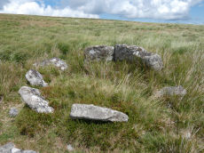
Skir Hill (Henroost) Ring Setting Cairn and Cist
OS Map: SX 65104 70686
HER: MDV6507
Megalithic Portal: 45676
PMD: Skir Hill
Alternate name: Skir Hill Ring Setting Cairn and Cist
Short Name: CT Skir Hill
Butler map: 61.8
Dixon Cist #: 18
Grinsell: LYD 102
Turner: D18
DPD: 92
Barrow Report: 24 56
Dimensions (m): 3.3 C
Notes: DM reports it is actually located at SX 65092 70684. The author has found this site at SX 65104 70691 on 28/06/18 assisted by the grid reference given by Dave Martin (DM). "A Bronze Age cairn containing a cist located on the north east facing slope of Skir Hill 590 metres south of Skir Ford. The cairn survives as a 4.1 diameter ring of edge set slabs up to 0.5 metres high. The cist is situated slightly west of the cairns centre and survives as a 0.82 metres long by 0.52 metres wide and 0.82 metres deep stone lined pit." Formerly listed as being at SX 6517 7075 (as per literature). Butler Vol. 4. Map 61.8 (diagram p.203).
Nearest Bus Stop: Dartmeet Badgers Holt (3.3 km) [Route: 172]
Nearby sites: SX 65104 70686
Dendles Waste Ring Setting Cairn and Cist
OS Map: SX 61535 62804
HER: MDV4276
Megalithic Portal: 45691
PMD: Dendles Waste
Alternate name: Dendles Waste S. Ring Setting Cairn and Cist
Short Name: CT Dendles 1
Butler map: 52.15
Dixon Cist #: 43
Grinsell: COR 14
Turner: D19
DPD: 64
Barrow Report: 43
Dimensions (m): 4.0 C
Notes: "The circle, consists of eight flat slabs, set on edge and has an internal diameter of approximately 3.4m. Some of the stones from the western quadrant of the circle are missing; a single earthfast stone is all that survives. The rectangular cist lies roughly centrally within the circle and is oriented E to W. It measures 1.2m long by 0.6m and 0.5m deep with slabs still in place both sides". Lethbridge diagram p.63, photo p.64. Butler Dendles Waste S. - Vol. 3. Map 52.15 (diagram p.194).
Nearest Bus Stop: Cornwood Crossways (3.4 km) [Route: 59]
Nearby sites: SX 61535 62804
Grims Grave Ring Setting Cairn and Cist
Prehistoric Dartmoor Walks: Dartmoor Site: Guide to the Langcombe Brook & Deadman's Bottom Cists
OS Map: SX 61245 66422
HER: MDV5083
Megalithic Portal: 14930
PMD: Grim's Grave
Short Name: CT Grims Grave
Butler map: 50.3.3
Dixon Cist #: 14
Grinsell: SHA 13
Turner: D20
DPD: 46
Barrow Report: 12 20 56
Dimensions (m): 5.5 x 0.6 C
Notes: "A ring cairn set into the slope, c 4.5m in diameter, with a cist at its centre. The cairn consists of a stony, turf-covered mound contained by a ring of upright slabs, most leaning outwards, c 1m in height; the mound rises to c 0.4m at top of cist. The cist, box dimensions c 0.8m x 0.95m internally, is formed from edge-set slabs. One side slab is c 1.7m long, 0.9m wide and 0.2m thick. The monument survives in a very good condition though the cover-stone is missing - this is possibly the slab that now lies on the down-slope side." Lethbridge p.46 Langcombe Cist G (Grim's Grave) - diagram p.43. Butler Vol. 3. Map 50.3 Cairn 3 (pp.148-54 general plan of Langcombe Brook cairns p.151, diagram of Langcombe cists p.153, photo pp.94-96).
Grinsell [Folklore 1976]: The name Grim's Grove, or Grim's Grave, is shown near here on the surveys of Dartmoor Forest of 1240 and 1609, and was identified as this site by C. Spence Bate, an identification which has had supporters and critics. Bate 1872, 531-2; Crossing 1912/1965, 408.
Nearest Bus Stop: Lee Moor Clearview (6.1 km) [Route: 59]
Nearby sites: SX 61245 66422
Royal Hill, North Ring Setting Cairn and Cist
OS Map: SX 62108 72434
HER: MDV6305
Megalithic Portal: 34959
PMD: Royal Hill NE.
Alternate name: Royal Hill E.5 Ring Setting Cairn and Cist
Short Name: CT RoyalHill 5
Butler map: 65.5.5
Dixon Cist #: 24
Grinsell: LYD 90
Turner: D21
DPD: 98
Barrow Report: 27 47
Dimensions (m): 3.0 x 0.3 C
Notes: "The circle is 3.1m in overall diameter, comprising nine contiguous thick slabs, up to 0.9m long and from 0.3m to 0.7m high... There is virtually no cairn material but the interior has been levelled up to a height of 0.1m on the E, downhill side. A central cist oriented WNW to ESE is represented by two side stones which protrude 0.15m above ground. They are 1.2m and 0.9m long and both about 0.2m thick and 0.4m deep. The longer, northern one leans inwards and touches the other at the W end; at the E the stones are 0.8m apart separated by two flat (packing ?) stones each about 0.35m across. An overgrown and embedded slab against the circle W if the cist may have been an end stone." Lethbridge diagram p.97 Cist C, photo p.98. Butler Royal Hill E. 5 (Cairn 5 - diagram p.233)- Vol. 4. Map 65.5. Central cist. Breton p.19.
Nearest Bus Stop: Two Bridges Hotel (2.8 km) [Route: 98,171,172]
Nearby sites: SX 62108 72434
Plym Steps Ring Setting Cairn and Cist
Prehistoric Dartmoor Walks: Dartmoor Site: Guide to the Langcombe Brook & Deadman's Bottom Cists
OS Map: SX 60427 67110
HER: MDV5133
Megalithic Portal: 45659
PMD: Langcombe Brook 8
Alternate name: Langcombe Brook 8 Ring Setting Cairn and Cist
Short Name: CT Plym Steps
Butler map: 50.3.8
Dixon Cist #: 6
Grinsell: SHA 4
Turner: D22
DPD: 44
Barrow Report: 19
Dimensions (m): 5.0 x 0.2 C
Notes: Central cist. Butler Langcombe Brook 8 (Cairn 8)- Vol. 3. Map 50.3 (pp.148-54 general plan of Langcombe Brook cairns p.151, diagram of Langcombe cists p.153). Lethbridge p.44 Langcombe Cist B - diagram p.43
Nearest Bus Stop: Meavy Primary School (6.0 km) [Route: 56]
Nearby sites: SX 60427 67110
Goldsmith's Cross E.2. Ring Setting Cairn and Cist
OS Map: SX 61804 70321
HER: MDV6342
Megalithic Portal: 42707
PMD: Fox Tor Mires cairn
Alternate name: Goldsmith's Cross E.2 Ring Setting Cairn and Cist
Short Name: CT GoldsmithE2
Butler map: 64.5.2
Dixon Cist #: 113
Grinsell: LYD 95
Turner: D23
DPD: 95
Dimensions (m): 2.5 C
Notes: "West end stone of cist leans slightly inwards, otherwise a perfect cist measuring 0.75m NW-SE by 0.5m wide by 0.4m deep. Retaining circle of 7 stones averaging 0.4m high. No coverstone or barrow". Lethbridge diagram p.93, photo bottom right p.95 and on p.96. Turner D23 (Fox Tor Mire) - Proc Devon Arch Soc 48 (diagram p.45). Butler Goldsmith's Cross E. 2 - Vol. 4. Map 64.5 (Cairn 2 - diagram p.221).
Nearest Bus Stop: Princetown Dartmoor Visitor Centre (4.2 km) [Route: 98,171,172]
Nearby sites: SX 61804 70321
Archerton S.W. (Rowtor Brook) Ring Setting Cairn and Cist
OS Map: SX 62752 78808
HER: MDV5838
Megalithic Portal: 37604
PMD: Hollowcombe Bottom
Alternate name: Rowtor Brook 3 Ring Setting Cairn and Cist
Short Name: CT RowtorBr 3
Butler map: 27.17.3
Butler Vol 5: p.55 & Fig.33
Dixon Cist #: 75
Grinsell: LYD 42
Turner: D24
DPD: 112
Barrow Report: 57
Dimensions (m): 7.0 x 1.0 C
Notes: Breton: on N. side of wall is a kistvaen, around which is a triple circle, a very unusual feature..
HER: The cist lies within three concentric circles of stones at 10, 15 and 24 feet diameters, the inner ring being of large stones, the middle ring of smaller stones and the outer ring of even smaller stones. The cist measures internally 0.8m by 0.6m and 0.9m deep. Half of its capstone lies across its north end.
For more information see: Lethbridge Hollowcombe Bottom, diagram and photo p.112. Butler Rowtor Brook 3 - Vol. 2. Map 27.17 (diagram Vol. 5. p.55). Breton p.35
Nearest Bus Stop: Postbridge Post Office (2.0 km) [Route: 98,171]
Nearby sites: SX 62752 78808
Sittaford Tor Ring Setting Cairn and Cist
OS Map: SX 63479 82641
HER: MDV21894
Megalithic Portal: 45792
PMD: Sittaford Tor
Alternate name: Sittaford Tor S. Ring Setting Cairn and Cist
Short Name: CT Sittaford
Butler map: 34.3
Butler Vol 5: p.183 & Fig.126
Dixon Cist #: 134
Turner: D25
DPD: 125
Dimensions (m): 6.0 x 0.3
Notes: "Cairn 5 metres in diameter, 0.75 metres high. Surrounded by two rings of kerb stones up to 0.75 metres high. Many stones forming the outer ring are recumbent. Mound material up to 0.2 metres high. Inner kerb is 2.8 metres diameter and the outer is 5 metres diameter. Slab in centre may be an intact cist. Grass and rushes. Animal poaching on western side of cairn.". "This mutilated kerbed cairn is situated on a peat-covered moorland slope below Sittaford Tor at 488m OD. It measures about 5m in diameter and comprises a probably (hidden) central cist set within twin concentric kerbs of granite slabs." Lethbridge photo bottom p.125. Butler Sittaford Tor S (Cairn 3) Vol. 2. Map 34.3 (p.112, also Butler Vol. 5. diagram p.183).
Nearest Bus Stop: Postbridge Post Office (4.0 km) [Route: 98,171]
Nearby sites: SX 63479 82641
Page last updated 12/07/15