
Ger Tor Platform Cairn Circle
Database entries
OS Map: SX 5465 8337
OS Source: HER
Butler OS: SX54658333
HER: MDV11809
Megalithic Portal: 45645
Alternate name: Ger Tor Summit
Short Name: PC:Ger Tor 1
Butler map: 32.4
Turner: E24
Exist: Yes
Record: Unique
Record Source: Butler
Hut Class: No
Cairn Class: Yes
Dimensions (m): 6.0 x 0.4
Lidar: SX 5465 8337
Guide Map: 15
Nearest Bus Stop: Dartmoor Inn (3.9 km) [Route: 118]
Nearby sites: SX 5465 8337
Notes
HER:A heather covered cairn which measures 6.6 metres by 7.1 metres in diameter and 0.6 metres in height, with part of a kerb visible on the southern side. Stones from a small excavation in the top have been thrown to the west side of the cairn. Note change of grid reference - was SX 54627 83330.UPDATE 31/12/2022. HER link changed from the now deleted MDV48908. NGRs updated accordingly to match MDV11809. This record previously had the Old NGR of SX 54627 83330 - approx 40m to the south of the current NGR.
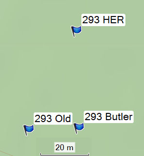
Turner: Cairn on ger tor, n side. Platform circle with ring of kerb stones 4.6m internal diam, enclosing flat-topped cairn 0.2m high. Much disturbed (turner).
References
These are selected references with an emphasis on out of copyright sources linked as PDFs. For more detailed references try any linked HER or PMD record above.
- Butler, Jeremy, Dartmoor Atlas of Antiquities, vol.2: The North, (1991)
- Turner, J.R., Ring Cairns, stone circles and related monuments on Dartmoor, D.A.S.P. No.48 pp.27-86 (1990)