
Deadmans Bottom D Platform Cairn Circle and Cist
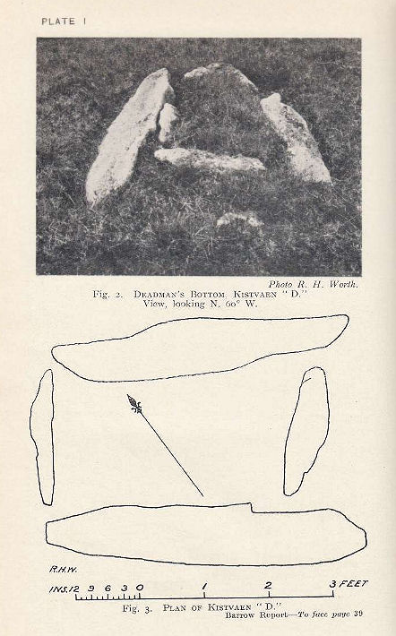
Plan by RHW. Barrow Report 53. TDA Vol.66 1934
Database entries
PDW coverage: Dartmoor Site: Guide to the Langcombe Brook & Deadman's Bottom Cists
OS Map: SX 6096 6673
OS Source: HER
Butler OS: SX60956673
HER: MDV5086
Megalithic Portal: 45731
PMD: Deadman's Bottom S 10
Alternate name: Langcombe Brook 10
Short Name: CT:Deadmans D
Butler map: 50.3.10
Dixon Cist #: 55
Grinsell: SHAUGH PRIOR 10
Turner: E44
DPD page: 45
Exist: Yes
Record: Unique
Record Source: Butler
Hut Class: No
Cist Class: Yes
Cairn Class: Yes
Barrow Report: 53
Dimensions (m): 0.8 x 0.7 C
Lidar: SX 6096 6673
Guide Map: 50
Nearest Bus Stop: Lee Moor Clearview (7.9 km) [Route: 59]
Nearby sites: SX 6096 6673
Notes
"The cairn is 5m in diameter by 0.3m high with a retaining kerb on its northern side. The cist is 0.8m long b 0.7m wide." "Cist (listed as 'D' by Worth) found at Deadman's Bottom Langcombe, by Mr Button. Internal dimensions, length 3 feet 8 inches, width 2 feet. The stones are barely visible above grass level. The cover stone is missing." Lethbridge p.45 Langcombe Cist E - diagram p.43. Butler Langcombe Brook Cairn 10 - Vol. 3. Map 50.3 (pp.148-54 general plan of Langcombe Brook cairns p.151, diagram of Langcombe cists p.153).References
These are selected references with an emphasis on out of copyright sources linked as PDFs. For more detailed references try any linked HER or PMD record above.
- Butler, Jeremy, Dartmoor Atlas of Antiquities, vol.3: The South-West, (1994)
- Grinsell, L.V., Dartmoor Barrows, Devon Archaeological Society Proceedings No.36 (1978)
- Lethbridge, William D., Discover Preshistoric Dartmoor, (2015)
- Turner, J.R., Ring Cairns, stone circles and related monuments on Dartmoor, D.A.S.P. No.48 pp.27-86 (1990)
- Worth, R. Hansford, Barrow Report 53, T.D.A. Vol.66 pp.39-42 (1934)
- Worth, R.N., Barrow Report 12, T.D.A. Vol.22 pp.49-52 (1890)