
The Turner Classification of Cairns
Turner used the following clasifications for stone circles and cairns:
Listing of Turner Cairns: B Embanked Stone Circles
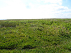
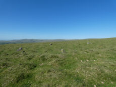
Wigford Down 4 Embanked Cairn Circle
OS Map: SX 54694 64972
HER: MDV2368
Megalithic Portal: 3536
Short Name: CC Wigford 4
Butler map: 48.1.4
Grinsell: MEA 7a
Turner: A39
Barrow Report: 12 62
Dimensions (m): 10.0 x 0.5
Notes: Listed as Wigford Down B on Tom Greeves list of potential 'Sacred' Pools.
NMR B. "Stone ring, diam 10.5m, with bank 2.5m wide and 0.5m high.3m wide entrance on s side" See Butler Vol 3 p.97 fig. 48.1.2. Wigford Down 3 in Barrow Report 62.
This ring cairn survives as a circular bank measuring up to 3.5 metres wide and 0.75 metres high which surrounds a flat interior up to 17.5 metres in diameter. There is evidence for partial early excavation or robbing on the south west side. Noted in 2019 as a possible 'sacred' pool.
Nearest Bus Stop: Shaugh Prior White Thorn Inn (1.9 km) [Route: 59]
Nearby sites: SX 54694 64972
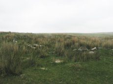
Deadman's Bottom Embanked Cairn Circle
Prehistoric Dartmoor Walks: Dartmoor Site: Guide to the Langcombe Brook & Deadman's Bottom Cists
OS Map: SX 60711 67027
HER: MDV12420
Megalithic Portal: 3194
Alternate name: Deadman's Bottom 1 Embanked Cairn Circle
Short Name: CC Deadmans 1
Turner: B1
Dimensions (m): 16
Notes: "Turner identifies this site as an embanked stone circle; an annular bank of earth and/or stones with an inner edge of orthostats. Internal diam 16m with bank 0.8m wide and 0.3m high. The bank has been pushed out on the sse side and the stones lean outward (turner)." Turner B1.
Nearest Bus Stop: Lee Moor Clearview (6.2 km) [Route: 59]
Nearby sites: SX 60711 67027
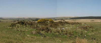
Merrivale Embanked Cairn Circle and Cist
OS Map: SX 55360 74747
HER: MDV4997
Megalithic Portal: 10503
PMD: Merrivale SW.
Alternate name: Merrivale 8 Embanked Cairn Circle and Cist
Short Name: CT Merrivale 8
Butler map: 44.8.8
Dixon Cist #: 139
Grinsell: WAL 1
Turner: B2
Dimensions (m): c.20.0
Notes: "The excavation of 1851 seems to have been thorough, completely destroying structural remains of both the cairn and the 'cist or inner circle',. There is now a circular turf covered area, 18.0m. in diameter, with random stones protruding through the surface. Off centre there is a hollow, 7.0m. by 4.0m. and 0.5m. deep." Butler Merrivale Vol. 3. Map 44.8.8 (pp.30-1).
Nearest Bus Stop: Merrivale Dartmoor Inn (0.6 km) [Route: 98,171,172]
Nearby sites: SX 55360 74747
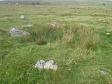
Cator Common Embanked Cairn Circle
Prehistoric Dartmoor Walks: Dartmoor Site: Cator Pound
OS Map: SX 67426 78001
HER: MDV5978
Megalithic Portal: 52173
Short Name: CC CatorCommon
Butler map: 18.4
Grinsell: WID 1
Turner: B3
Dimensions (m): 18
Notes: HER: Cairn, hollow towards centre. Retaining circle of c.28 upright slabs, mostly turned inwards. Diameter 18.0m, height 0.6m. Breton p.41
Nearest Bus Stop: Postbridge Bellever (2.0 km) [Route: 98]
Nearby sites: SX 67426 78001
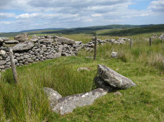
Cudlipptown Down Embanked Cairn Circle
OS Map: SX 53732 78949
HER: MDV13252
Megalithic Portal: 45608
Alternate name: White Tor N.W.2 Embanked Cairn Circle
Short Name: CC White NW2
Butler map: 31.23.2
Butler Vol 5: p.188 & Fig.130
Grinsell: PET 21
Turner: B5
Dimensions (m): 16.0 x 0.3
Notes: "A ring cairn set at the eastern end of a natural gently sloping plateau of rough grassland generally devoid of stones. It measures about 11m diameter inside a turf-covered bank, composed generally of smallish stones, which is about 2.2m wide and has a maximum height of 0.4m on the E. It has been mutilated and spread in the south-east and the west. Several stones, are evident, two probably set in the inner face but the rest are apparently part of the bank of even part of the outer face. Two in the east on the uphill side appear to form an entrance but this is possibly due to mutilation. The interior appears to have been levelled and is 0.2m above the ground to the W. There is no evidence of any internal features or a ditch"
Nearest Bus Stop: Mary Tavy War Memorial (3.5 km) [Route: 118]
Nearby sites: SX 53732 78949
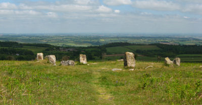
Mardon Down Embanked Cairn Circle
Prehistoric Dartmoor Walks: Dartmoor Site: Mardon Down Stone Circle & Cairns
OS Map: SX 76744 87691
HER: MDV8308
Megalithic Portal: 3375
Alternate name: Mardon Down Pillared Circle 5 Embanked Cairn Circle
Short Name: CC Mardon 5
Butler Vol 5: p.150 & Fig.92
Grinsell: MOR 1
Turner: B6
DPD: 149
Dimensions (m): 10 x 0.7
Notes: Impressive cairn circle with a well preserved ring of large pillars surrounded by an outer kerb ring of smaller slabs on their edges. The cairn is 11m. in diameter and 0.5m. high, with a well preserved cairn circle comprising a 9.0m. diameter circle of spaced uprights averaging 0.8m. high, with kerbing between. Unlike the stone circle it is marked on the OS Okehampton and North Dartmoor Landranger map (Sheet 191). It is easy to confuse this cairn with the less well preserved stone circle which is a few hundred metres to the south. Turner B6.
Nearest Bus Stop: Moretonhampstead Court Street Car Park (2.3 km) [Route: 171,173]
Nearby sites: SX 76744 87691
Joan Ford's Newtake Embanked Cairn Circle and Cist
OS Map: SX 63143 72168
HER: MDV6260
Megalithic Portal: 3295
PMD: Joan Ford's Newtake
Alternate name: Joan Ford's Newtake 1 Embanked Cairn Circle and Cist
Short Name: CT Joan Fords
Butler map: 63.3.1
Dixon Cist #: 28
Grinsell: LYD 92
Turner: B7
DPD: 99
Barrow Report: 30 56
Dimensions (m): 8.0 x 0.4
Notes: "A low kerb within the disturbed fringes of the mound is 8.7m in diameter with more or less continuous upright slabs and boulders 0.3m to 0.6m high. A dry stone newtake wall crosses the N side and overlies part of the kerb. A well-preserved cist, oriented NW-SE, is internally 1.0m long, 0.5m to 0.65m wide and up to 0.7m deep. The coverstone leans against the SE side of the cist and measures 1.35m by 1.0m by 0.2." Lethbridge diagram p.99, photo bottom p.99. Butler Joan Ford's Newtake 1 - Vol. 4. Map 63.3 (diagram p.214).
Nearest Bus Stop: Two Bridges Hotel (3.6 km) [Route: 98,171,172]
Nearby sites: SX 63143 72168
Merrivale North Embanked Cairn Circle
OS Map: SX 55340 74845
HER: MDV3757
Megalithic Portal: 10502
Alternate name: Merrivale 10 Embanked Cairn Circle
Short Name: CC Merrivale10
Butler map: 44.8.10
Turner: B8
Dimensions (m): 9
Notes: "Turner describes this site as an embanked stone circle; an annular bank of earth and/or stones with an inner edge of orthostats. Internal diameter is 8.0 meters with a bank 0.8 meters wide and 0.3 meters high. Much disturbed." Turner B8.
Nearest Bus Stop: Merrivale Dartmoor Inn (0.6 km) [Route: 98,171,172]
Nearby sites: SX 55340 74845
Mardle Embanked Cairn Circle
OS Map: SX 67526 69359
HER: MDV5308
Megalithic Portal: 3374
Alternate name: Mardle Valley 1 Embanked Cairn Circle
Short Name: CC Mardle 1
Butler map: 58.12.1
Turner: B11
Dimensions (m): 12.0 x 0.3
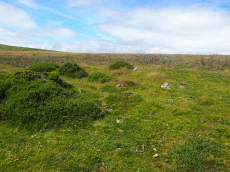
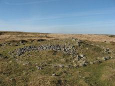
Notes: Turner: Embanked stone circle; an annular bank of earth and/or stone with an inner edge of orthostats. Much disturbed. Internal diam 6.5m with bank 1.2m wide and 0.4m high. This cairn has a very interesting structure appearing to be multiple circles of stones similar to the cairns at Corringdon Ball. This structure is difficult to capture in a photograph as the stones are small and the site much disturbed.
HER: A flat-topped cairn with a disturbed bank around its crest lies on a moderate south-west slope above the left bank of the River Mardle. The feature is circular, 11.8 metres in diameter, and stands a maximum of 0.8 metres high. The stoney ring measures 1.2 metres wide and 0.3 metres high and there are no traces of a cist or kerb in the main structure. The source of the disturbance is unclear though there does not appear to have been an excavation.
This cairn has been cleared of vegetation by the DPA in September 2025 and the author visited shortly afterwards on 02/10/2025. The main photo is from 15/07/2016 and the secondary photo was taken after the recent clearance work. The grid reference taken on 02/10/2025 was SX 67524 69358 which is a close match to the retained one from 2016.
Nearest Bus Stop: Dartmeet Badgers Holt (3.9 km) [Route: 172]
Nearby sites: SX 67526 69359
Harbourne Head B Embanked Cairn Circle
OS Map: SX 69147 65009
HER: MDV5803
Megalithic Portal: 3279
Alternate name: Parnell's Hill 2 Embanked Cairn Circle
Short Name: CC Harbourne B
Butler map: 57.31.7
Grinsell: DEA 10
Turner: B12
Dimensions (m): 23.0 x 1.5
Notes: "Embanked stone circle; annular bank of earth and/or stones with inner kerb of orthostats. Measures 15.0 metres in diameter internally with bank 2.0 metres wide and 0.5 meters high with a cairn in the centre, 9.0 metres in diameter and 1.1 metres in height. The west and south sides have been disturbed."
Nearest Bus Stop: South Brent Pool Park (5.2 km) [Route: 38]
Nearby sites: SX 69147 65009

Mis Tor Farm Embanked Cairn Circle
OS Map: SX 56927 75953
HER: MDV15372
Megalithic Portal: 45609
Alternate name: Little Mis Tor S.E. Embanked Cairn Circle
Short Name: CC:MisTor Farm
Butler map: 30.17
Butler Vol 5: p.163 & Fig.104
Grinsell: LYD 37a
Turner: B13
Dimensions (m): 22.0 x 0.4
Notes: HER Base of ancient tumulus, about 20m in diameter, may have formed a bound of the ancient boundary between Lydford and Walkhampton (Prowse). Butler: Little Mis Tor SE cairn at SX56927595 of 22.0 metres diameter by 0.4 metres high. This large but low cairn has suffered some trenching around the eastern side. An outer bank 22 metres across surrounds a level interior rising to a small mound at the centre on which are lying several small stones. The few slabs visible within the bank show that it was built with inner and outer faces around a rubble core.
Nearest Bus Stop: Merrivale Dartmoor Inn (2.2 km) [Route: 98,171,172]
Nearby sites: SX 56927 75953
Cosdon Beacon Embanked Cairn Circle and Cist
Prehistoric Dartmoor Walks: Dartmoor Site: Cosdon Hill Triple Stone Row
OS Map: SX 63708 91593
HER: MDV6898
Megalithic Portal: 10325
PMD: Cosdon Summit S.
Alternate name: Cosdon Hill 3 Embanked Cairn Circle and Cist
Short Name: CT Cosdon 3
Butler map: 40.7.3
Butler Vol 5: p.164 & Fig.105
Dixon Cist #: 120
Grinsell: ST 2
Turner: B14
DPD: 152
Barrow Report: 21
Dimensions (m): c.18.0 x 0.4
Notes: "Ring cairn and cist on summit ridge of Cawsand Hill. Cairn forms part of a cemetery including at least 2 round cairns, 2 ring cairns and one platform cairn. Earthwork survives as a 2m wide and 0.4m high circular rubble bank, faced with close set stones around its outer edge and surrounds an internal area measuring 18m ew by 17m ns. A mound measuring 6m in diam and 0.2m high stands in the centre of the area enclosed by the circular bank and contains a stone cist with 2 slabs surviving." Turner B14(diagram p.59). Butler Cosdon Beacon 3 Vol. 2. Map 40.7.3 (diagram Vol. 5. p.164). NMR Cairn B. Possible cist? This site is difficult to photograph, the photo shows part of one side of the ring.
Nearest Bus Stop: Ramsley (2.0 km) [Route: 670,671,6A]
Nearby sites: SX 63708 91593
Page last updated 12/07/15