
Yar Tor (Money Pit) Platform Cairn Circle and Cist
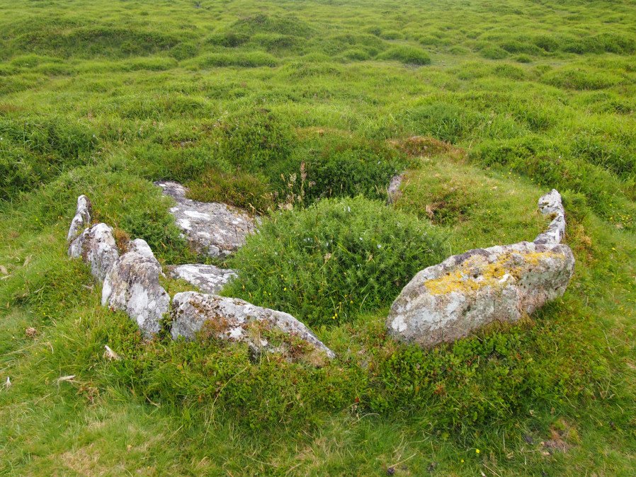
Photo taken on 06-06-2025
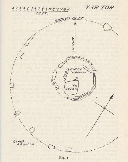
Plan by RHW. Barrow Report 56. TDA Vol.69 1937
Database entries
OS Map: SX 68181 73865
OS Source: Google
Butler OS: SX68177385
HER: MDV6460
Megalithic Portal: 1369
PMD: Money Pit
Alternate name: Money Pit
Short Name: CT Money Pit
Butler map: 14.11
Butler Vol 5: p.23 & Fig.4
Dixon Cist #: 69
Grinsell: WIDECOMBE IN THE MOOR 21
Turner: E51
DPD page: 122
Exist: Yes
Record: Unique
Record Source: Butler
Hut Class: No
Cist Class: Yes
Cairn Class: Yes
Barrow Report: 56 62
Dimensions (m): c3.2 cist 1.0 x 0.4
Lidar: SX 68181 73865
Guide Map: 36
Nearest Bus Stop: Postbridge Bellever (5.7 km) [Route: 98]
Nearby sites: SX 68181 73865
Notes
"The south cairn is a very spread and slight earthwork with a centrally placed cist. Only the north and west side slabs of the cist remain in situ though a misplaced slab lies to one side of the chamber. Eleven slabs forming a kerb of approximately 3m surrounding the cist remain in situ. Several additional stones survive, protruding just above the surface of the flattened cairn, which are likely to be evidence of an outer circle with a diameter of approximately 11m". Lethbridge diagram p.122 and photo bottom p.122. Butler Money Pit - Vol. 1. Map 14.11 (photo on p.92, diagram pp.125-6).References
These are selected references with an emphasis on out of copyright sources linked as PDFs. For more detailed references try any linked HER or PMD record above.
- Burnard, Robert, Notes on Dartmoor Kistvaens, T.D.A. Vol.22 pp.200-207 (1890)
- Butler, Jeremy, Dartmoor Atlas of Antiquities, vol.1: The East, (1991)
- Butler, Jeremy, Dartmoor Atlas of Antiquities, vol.5: The Second Millennium B.C., (1997)
- Grinsell, L.V., Dartmoor Barrows, Devon Archaeological Society Proceedings No.36 (1978)
- Lethbridge, William D., Discover Preshistoric Dartmoor, (2015)
- Turner, J.R., Ring Cairns, stone circles and related monuments on Dartmoor, D.A.S.P. No.48 pp.27-86 (1990)
- Worth, R. Hansford, Barrow Report 56, T.D.A. Vol.69 pp.75-109 (1937)
- Worth, R. Hansford, Retaining circles associated with stone rows Dartmoor, T.D.A. Vol.73 pp.227-38 (1941)
- Worth, R. Hansford, Barrow Report 62, T.D.A. Vol.75 pp.53-55 (1943)