
Prehistoric sites within 5km of SX 70067 87546
Guidance for walkers: The monuments featured in this database are archaeological treasures and need to be protected and preserved - please do not disturb any sites. Please check access and firing times before visiting sites, not all sites listed are on open access land. Firing ranges and boundaries of open access areas are marked on the OL28 OS Dartmoor Explorer map. Please stick to the country code and consider giving support to the numerous agencies that help to keep Dartmoor a fabulous natural and historic environment!
About the database listings: In all listings clicking on the photo or the site name will open a page for the site with a larger photo and further details from the database. The database now has over 6680 records covering nearly all publicly listed sites on Dartmoor including around 4800 round houses. This level of detail is of interest to archaeologists but tends to swamp listings of sites more likely to be of interest for walkers. For this reason, the listings default to around 550 core sites only. These are the stone circles, stone rows and the ring cairns listed by Turner. The default search radius is 2 km. The controls below the map can be used to start a new search by entering a 6- or 8-digit reference (without the prefix "SX"). The search radius can be specified and you can add incremental Display layers of detail on top of the core sites. If using a more detailed layer you will need to decrease the search radius to avoid getting hundreds of search results.
- Core sites Default listing of core sites consisting of stone circles & rows and some of the major ring cairns.
- Plus cairns adds approx. 1000 cairns and other minor sites not included in the core listings but excluding round houses.
- Plus round houses adds approx. 4800 round houses.
- Plus non-sites adds in the records for sites that no longer exist or are not prehistoric sites.
- Plus duplicates adds records excluded as duplicates. Those maybe duplicate records in external listings (e.g. the Historic Environment Records). For example, some sites have been identified as cairns in some listings and interpreted as round houses in other listings and both records appear.
These listings have incorporated, matched up and merged all of the records from all of the major archaeological listings including: Worth, Grinsell, Turner, Butler, Bill Radcliffe, Sandy Gerrard, Megalithic Portal, the National Monument Records and the Historic Environment Records. The author would like to thank Bill, Sandy, the lovely people both at Megalithic Portal (especially Anne Tate who did an amazing job to link listings) and at ACE Archaeology for collaborative work over the years to synchronise and correct listings across the various websites which now interlink. A culmination of years of work the final merger of cairn records took 3 months of cross referencing in 2017 the result being a snapshot of the records at that time. This data has in turn been refined since by field work and research. The round house data was supplied by Sandy Gerrard. Grid references are in order of accuracy: from Google Earth satellite, if visible and found, from a Garmin GPS reading, if visited by the author and from the literature otherwise. Individual site pages will state the source of the grid reference and provide satellite imagery. If a site listing lacks a photo it has not yet been visited by the author in which case the grid reference is from the literature.
Currently the database only includes sites which can be represented by a grid reference. Reaves are not included as they require GIS shape technology which is beyond the current capability of this system. To see the sources for the records, look at the tables on the resources menu. The database listings can also be viewed on a Google map and downloaded as GPS datasets for Garmin devices.
Corrections, or any feedback or suggestions are very welcome, email: info@dartmoorwalks.org.uk.
NOTE: Clicking on the icons for each monument in the map will give the name of the site. You can zoom in and out and drag the map around.
List of sites within 5km of SX 70067 87546

Scorhill S.1 Platform Cairn Circle
OS Map: SX 65534 87272
HER: MDV130493
Megalithic Portal: 25238
ShortName: PC Scorhill S1
Butler map: 38.8.1
Butler Vol 5: p.249 & Fig.175
Turner: E25
Notes: "A platform circle; ring of kerb stones 4.5m internal diam, enclosing flat-topped cairn 0.45m high. Indication of a stone ring/ring cairn beneath cairn (turner)." Entry added by PDW to correct/replace Butler 38.4.1. This is cairn 1 in Fig. 175 (p.249 Vol 5). Formerly listed as PC:Scor Leat
Nearby sites: SX 65534 87272
Distance: 4.54km
Thornworthy Corner W. Cairn Circle
OS Map: SX 6599 8550
HER: MDV48855
ShortName: CN?Thornwort W
Butler map: 36.7
Grinsell: LYD 9
Turner: A24
Notes: HER: Ring cairn of 6.0 metres diameter with bank 1.8 metres wide by 0.6 metres high on Shovel Down
Nearby sites: SX 6599 8550
Distance: 4.56km
Shapley Common 1 Cairn
OS Map: SX 6969 8276
HER: MDV64821
ShortName: CN:Shapley 1
Butler map: 23.5.1
Notes: HER: A platform cairn situated on the north facing slope of a prominent ridge, approximately 550 metres north of Shapley Tor. The cairn includes a 12 metre diameter circular platform standing 0.2 metres high. On this platform stands an ovoid flat-topped cairn measuring 9.7 metres east to west by 7.5 metres and standing a maximum of 0.8 metres high. The sides of the mound are heather clad while the top is grassy with some stone protruding. There is no evidence to suggest the presence of a cist or kerb.
Nearby sites: SX 6969 8276
Distance: 4.80km
Shapley Common 2 Cairn
OS Map: SX 69869 82580
HER: MDV6726
ShortName: CN:Shapley 2
Butler map: 23.5.2
Notes: A disturbed heather covered cairn lies on the gently sloping north east flank of Shapley Tor. The slightly ovoid mound measures 8.6 metres north to south by 8 metres and stands a maximum of 1 metres high. An ovoid hollow 2.5 metres by 3 metres and around 0.4 metres deep is visible in the centre of this feature.
Nearby sites: SX 69869 82580
Distance: 4.97km
Chagford Common 1 Cairn
OS Map: SX 6780 8365
HER: MDV64199
ShortName: CN:Chagford 1
Butler map: 25.7
Grinsell: CHA 7, 8, 9, 10
Notes: CHA 7, 8, 9, 10
Nearby sites: SX 6780 8365
Distance: 4.51km
Scorhill S.2 Cairn
OS Map: SX 65485 87212
HER: MDV6196
PMD: Scorhill S.
ShortName: CN Scorhill S2
Butler map: 38.8.2
Butler Vol 5: p.172 & Fig.112
Grinsell: GID 2a
Notes: Entry added by PDW to correct/replace Butler 38.4.2. This is cairn 2 in Fig. 175 (p.249 Vol 5), it is the cairn that heads the claimed stone row on Fig 112.
Formerly CN:Scorhill 8
Nearby sites: SX 65485 87212
Distance: 4.59km
Scorhill N.1 Cairn
OS Map: SX 65740 87734
HER: MDV6201
ShortName: CN Scorhill N1
Butler map: 38.10.1
Butler Vol 5: p.186 & Fig.129
Grinsell: GID 4
Notes: Entry added by PDW to correct/replace Butler 38.10.1 One of a pair of cairns on the eastern edge of Gidleigh Common. Scheduled. Round cairn with two kerbs, 7.5 metres and 9.5 metres in diameter. Central disturbance. See also Butler Vol 5 p. 249 fig. 175
Nearby sites: SX 65740 87734
Distance: 4.33km
Scorhill N.2 Cairn
OS Map: SX 65755 87754
HER: MDV6211
PMD: Creaber
ShortName: CN Scorhill N2
Butler map: 38.10.2
Butler Vol 5: p.249 & Fig.175
Grinsell: GID 5
Notes: Entry added by PDW to correct/replace Butler 38.10.2 Two cairns; probably the two objects (kists?) shown by Crawford (1950). Round cairn diameter 12 metres, height 0.6 metres. A robbing pit south of centre is 2.5 metres long, 1.8 metres wide by 0.3 metres deep and is orientated at 120 degrees.
Nearby sites: SX 65755 87754
Distance: 4.32km
Metherall Cairn
OS Map: SX 6684 8401
HER: MDV6655
Megalithic Portal: 15138
PMD: Metherel
ShortName: CT?Metherall
Turner: C2
Barrow Report: 56
Notes: Cairn or hut circle? Excavation of three hut circles in 1936, prior to the construction of new reservoir at Fernworthy, showed the eastern circle, "No 6" (SX66858402), to represent the remains of a cairn with a probable cremation burial in a pit beneath a cover-stone.
Nearby sites: SX 6684 8401
Distance: 4.79km
Chagford Common 2 Cairn
OS Map: SX 6785 8359
HER: MDV13036
ShortName: CN:Chagford 2
Grinsell: CHA 7
Notes: Disturbed cairn. See also CHA 10a-i NMR 443914
Nearby sites: SX 6785 8359
Distance: 4.53km
Chagford Common 3 Cairn
OS Map: SX 6784 8362
HER: MDV13037
ShortName: CN:Chagford 3
Grinsell: CHA 8
Notes: Round cairn. Diameter 4.7 metres, height 0.4 metres. Slight unsurveyable central hollow. A fragmentary and spread bank leads away from this mound towards the nearby agglomerated enclosure. See also CHA 10a-i NMR 443914
Nearby sites: SX 6784 8362
Distance: 4.51km
Chagford Common 4 Cairn
OS Map: SX 6785 8364
HER: MDV13038
ShortName: CN:Chagford 4
Grinsell: CHA 9
Notes: cairn, slight hollow centre. Diameter 6m, height 0.4m. See also CHA 10a-i NMR 443914
Nearby sites: SX 6785 8364
Distance: 4.49km

Yardworthy stone row Cairn
OS Map: SX 67601 84390
HER: MDV14228
ShortName: CN Yardworthy
Notes: HER: Small cairn situated at the south-western end of the remains of a double stone row. The cairn is bout 4 metres by 2.8 metres by 0.4 metres high.
Nearby sites: SX 67601 84390
Distance: 4.01km
Buttern Hill 5 Cairn
OS Map: SX 6523 8849
HER: MDV28684
ShortName: CN:Buttern 5
Notes: HER: Poorly preserved remains of a small possible ring cairn, 4.0 metres in diameter, with a turfed over rim up to 0.4 metres high. Located during field investigation in 1978 and surveyed by the Ordnance Survey
Nearby sites: SX 6523 8849
Distance: 4.93km
Hurston Common Cairn
OS Map: SX 6766 8350
HER: MDV61934
ShortName: CN:Hurston
Notes: HER: Cairn or hut circle on the north side of a D-shaped enclosure on west side of Hurston Main Reave on Chagford Common. NB. Formerly listed here as "Hurston Ridge" which duplicates the name of another cairn to the SW. Renamed to Hurston Common (07/09/2025).
Nearby sites: SX 6766 8350
Distance: 4.71km
Chagford Common 5 Cairn
OS Map: SX 6784 8362
HER: MDV64200
ShortName: CN:Chagford 5
Nearby sites: SX 6784 8362
Distance: 4.51km
Buttern Hill 6 Clearance Cairn
OS Map: SX 6565 8917
HER: MDV103612
ShortName: CN:Buttern 6
Nearby sites: SX 6565 8917
Distance: 4.71km
Central Settlement Reported Cairn
OS Map: SX 6570 8624
HER: MDV134083
ShortName: CN?Central S1
Butler map: 36.4
Notes: Butler: "Another cairn, apparently undug, lies on the open hillside 250 m north of the enclosures downhill from several vry low mounds, all possible burial cairns".
Nearby sites: SX 6570 8624
Distance: 4.56km
Scorhill S.4 Reported Cairn
OS Map: SX 65520 87196
ShortName: CN Scorhill S4
Butler map: 38.4.1
Butler Vol 5: p.249 & Fig.175
Notes: Butler entry, coords given are for 38.8.1. Previously listed here as Scorhill S.1 (duplicate) CNxScorhill 7. In volume Two on p.243 are listed entries 4.1 and 4.2 as S.1 and S.2 which appears to duplicate other entries. The diagram in Fig. 175 in Volume 5 has 5 Scorhill South cairns. This entry and 4.2 have been resinstated as non-duplicates and arbitrarily assigned to S4 and S5.
Nearby sites: SX 65520 87196
Distance: 4.56km
Shoveldown Central Settlement Reported Cist
OS Map: SX 65764 85857
HER: MDV54531
PMD: Shovel Down W.
ShortName: CT:ShovelSet
Butler map: 36.4
Notes: This cairn is described by Butler on p. 176. "Forty metres outside the south-west corner a small solitary cairn (5.0 x 0.3m) has been dug into, the displaced stones subsequently returned to the central pit where they lie in a loose pile". The cairn is shown on Fig 36.4 on p.176. It can be seen to be a few metres south of the Central Settlement. It also appears towards the top left on Fig 36.7 on p. 179. Fig 36.4 is a segment of Fig 36.7. Butler lists this site as a cist at SX 6576 8585.
Nearby sites: SX 65764 85857
Distance: 4.62km
Scorhill S.5 Reported Cairn
OS Map: SX 65519 87191
ShortName: CN Scorhill S5
Butler map: 38.4.2
Butler Vol 5: p.172 & Fig.112
Notes: Butler entry, coords given are for 38.8.2. Previously listed here as Scorhill S.2 (duplicate), CNxScorhill 9. In volume Two on p.243 are listed entries 4.1 and 4.2 as S.1 and S.2 which appears to duplicate other entries. The diagram in Fig. 175 in Volume 5 has 5 Scorhill South cairns. This entry and 4.1 have been resinstated as non-duplicates and arbitrarily assigned to S4 and S5.
That leaves S3 missing next to S2 and a new record will be created to cover that one. The grid reference for S5 from Butler Vol 5 diagram approximates to SX 65519 87191.
Nearby sites: SX 65519 87191
Distance: 4.56km
Scorhill S.3 Reported Cairn
OS Map: SX 65494 87221
ShortName: CN Scorhill S3
Butler map: 38.8.3
Butler Vol 5: p.172 & Fig.112
Notes: Entry added by PDW. This is cairn 3 in Fig. 175 (p.249 Vol 5).
Nearby sites: SX 65494 87221
Distance: 4.58km
Scorhill N.3 Reported Cairn
OS Map: SX 6538 8775
HER: MDV132802
ShortName: CN:Scorhill N3
Notes: HER: Turner recorded a possible cairn here in 1978 but a subsequent Ordnance Survey visit cast doubt on the identification / location; appears a mis-identification of the hut circle MDV132781 to the north.
Nearby sites: SX 6538 8775
Distance: 4.69km
Shoveldown nr stone row Reported Cairn
OS Map: SX 6593 8608
HER: MDV13011
ShortName: CN:Shovel Do4
Turner: D30
Notes: "Abutting the west side of a double stone row is a circular depression 2m diameter, 0.2m deep. Perimeter lined with small earthfast slabs. It appears to be the kerb of a destroyed cairn or less probably an inner ring of orthostats of a larger now flat cairn which must then be partly overlaid by the stone row."
Nearby sites: SX 6593 8608
Distance: 4.39km
Leapra Rings Enclosure
OS Map: SX 700 826
HER: MDV26675
ShortName: EN:Leapra
Notes: HER: Leapra Rings consists of three possibly Prehistoric circular features on Shapeley Common
Nearby sites: SX 700 826
Distance: 4.95km
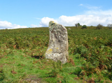
Butterdon Hill (nr. Moretonhampstead) Standing Stone
Prehistoric Dartmoor Walks: Dartmoor Walk: Butterdon Hill (nr Moretonhampstead) Standing Stone
OS Map: SX 74784 88403
HER: MDV8278
Megalithic Portal: 33950
PMD: Butterdon Down Standing Stone
Alternate name: Butterdon Down Standing Stone
ShortName: SS Butter Down
Notes: HER quoting J. V. S. Cocks Standing stone - prob. prehistoric. An upright stone, stands at the west edge of Butterdon Down, Moretonhampstead, beside the public footpath, 600 yards from Cranbrook Farm. It is between six and seven feet high and of slightly curved slab shape. Ref: Devon & Cornwall Notes & Queries 31 1970 pp. 225-26.
Nearby sites: SX 74784 88403
Distance: 4.79km
Buttern Hill Enclosed Settlement
OS Map: SX 65501 89146
HER: MDV6140
Megalithic Portal: 25242
ShortName: ES:ButternHill
Nearby sites: SX 65501 89146
Distance: 4.84km

Cranbrook Castle Fort
Prehistoric Dartmoor Walks: Dartmoor Walk: Butterdon Hill (nr Moretonhampstead) Standing Stone
OS Map: SX 73858 89023
HER: MDV8221
Megalithic Portal: 4624
ShortName: FT Cranbrook
Notes: "The outer rampart cuts or overlies the banks of an earlier field system. Upwards of 30 clearance cairns are visible in the interior; date unknown. The outer defences on the east and west sides are clearly incomplete. On the north side the inner rampart line is marked by 2 very low linear dumps of stone, which appear to have acted as markers for the front and rear of the rampart. No trace of an accompanying ditch. The original bivallate plan of the hillfort is reinforced by the abrupt termination on the west side of both the outer bank and inner bank and ditch in line. Other aspects of the unfinished hillfort are the irregularities in height of inner rampart on the south side. These probably mark divisions between construction gangs."
Nearby sites: SX 73858 89023
Distance: 4.07km
Gidleigh Reported Cairn
OS Map: SX 6554 8758
HER: MDV6188
ShortName: CC:Gidleigh
Notes: HER: Possible stone circle on Gidleigh Common, first recorded in 1925. Doubtful feature not positively identified since 1925.
(Area centred SX 65548758) Stone Circle, 6 metres in diameter. Ten stones remain, three still standing. (H H Breton undated but thought to be around 1925)
Doubtful; probably a retaining circle. (R H Worth, 1948). This is probably a reference to The Heart of Dartmoor.
This might be the round house approx. 100 metres to the south at SX 6566 8742.Scorhill Down Round House
Nearby sites: SX 6554 8758
Distance: 4.53km
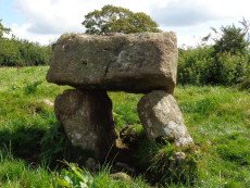
Gidleigh - North Chambered Tomb
OS Map: SX 65867 88956
HER: MDV6212
Megalithic Portal: 45581
PMD: Gidleigh North Chambered Cairn
Alternate name: Buttern Hill 2 Chambered Tomb
ShortName: NT Gidleigh N
Butler map: 38.7.2
Butler Vol 5: p.157
Grinsell: A:GID 1
Notes: "A chambered cairn located on an east facing slope of Buttern Hill. The cairn mound measures 26 metres long and 9 metres wide and stands up to 1 metre high. Several set stones at the western end of the mound represent the remains of a passage leading towards a chamber."
Nearby sites: SX 65867 88956
Distance: 4.43km
Gidleigh - South Chambered Tomb
OS Map: SX 6567 8855
HER: MDV6213
Megalithic Portal: 10040
PMD: Gidleigh South Chambered Cairn
Alternate name: Buttern Hill 1 Chambered Tomb
ShortName: NT Gidleigh S
Butler map: 38.7.1
Butler Vol 5: p.157
DPD page: 147
Notes: "The remains of a Neolithic chambered cairn on Buttern Hill. The cairn survives as a mound standing up to 0.6 metres high. The chamber and associated entrance passage include seven orthostats, two of which form a portaled entrance. A leat runs to the west of the cairn."
Nearby sites: SX 6567 8855
Distance: 4.51km

Gidleigh - South 2 Chambered Cairn
OS Map: SX 65534 88378
HER: MDV20318
Alternate name: Buttern Hill 3 Chambered Cairn
ShortName: NT Gidleigh S2
Notes: HER quoting Turner: Possible chambered cairn recorded at SX 6554 8837 on Gidleigh Common. A simple chamber cairn with evidence of a chamber (two fallen large stones at south, south-west end). Although many large boulders still remain in position, cairn has obviously been heavily robbed for later enclosure lying to the north.
Measurements: length 15.5m, width 3.5 to 5.5m, height 0.8m. This features differs from the other Gidleigh chamber tombs (North and South) as there is no evidence for a passage. It appears to be on the same axis and similar to the Corringdon ball example. Orientation south, south-west by north, north-east.
Nearby sites: SX 65534 88378
Distance: 4.61km
Heath Stone Standing Stone
Prehistoric Dartmoor Walks: Dartmoor Site: Hurston Ridge Double Stone Row
OS Map: SX 67133 83755
HER: MDV6650
Megalithic Portal: 14933
ShortName: SS Heath Stone
Butler map: 25.
Notes: The original Heath Stone was a boundary stone which was referred to in the Perambulation of the Forest of Dartmoor in 1240 and some very early maps. According to Butler (Vol. 2 Map 25 p.32) the stone carved with a biblical inscription in 1970 that is currently known as the Heath Stone is unlikely to have been the original Heath Stone as it is in a useless position to be of any use as a boundary stone. The stone was not included in maps from the 18th century and then reappeared in a different location. It is doubtful that the current stone is the original or that it is prehistoric. Crossing suggests that the large standing stone in the Hurston Ridge stone row is the actual Heath Stone. See also, Legendary Dartmoor: The Dartmoor Heathstone
Nearby sites: SX 67133 83755
Distance: 4.79km
Kes Tor Reported Cairn
OS Map: SX 66532 86276
HER: MDV21222
Alternate name: Kestor Reported Cairn
ShortName: CN-Kestor
Notes: "Possible tor cairn beneath sheer nw scarp of kes tor. Composed of even-sized smallish stones. Approx 12m diameter, c 2m high, though the surrounding scree makes accurate measurement difficult."
Nearby sites: SX 66532 86276
Distance: 3.76km
Kestor Enclosed Settlement
Prehistoric Dartmoor Walks: Dartmoor Site: Round Pound and Kes Tor Settlements
OS Map: SX 66397 86846
HER: MDV6114
Megalithic Portal: 4617
ShortName: ST Kestor
Notes: The Kestor Settlement includes the Round Pound.
Nearby sites: SX 66397 86846
Distance: 3.74km
Meacombe Cist
OS Map: SX 72500 86909
HER: MDV8231
Megalithic Portal: 10518
PMD: Meacombe Chambered Cairn
ShortName: CT Meacombe
Butler Vol 5: p.155 & Fig.94
DPD page: 148
Grinsell: A:CHA 1
Barrow Report: 49
Notes: Sometimes referred to as a chambered tomb due to the enormous size of the cover slab but it is more likey a cist. Butler Meacombe Cist Vol. 5. (diagram p.155).
Nearby sites: SX 72500 86909
Distance: 2.52km
Metherall Settlement
OS Map: SX 668 840
HER: MDV107529
Megalithic Portal: 15138
ShortName: ST:Metherall
Barrow Report: 56
Nearby sites: SX 668 840
Distance: 4.82km
Nattadon Fort
Prehistoric Dartmoor Walks: Dartmoor Resource: Table of Devon Iron Age Forts
OS Map: SX 70510 86638
HER: MDV8261
Megalithic Portal: 43578
ShortName: FT:Nattadon
Notes: HER: Constructed in a naturally defensive situation, the earthworks appear to be the setting out stage of a bivallate hilltop fortification, similar to Hunters Tor. It appears to be constructed upon a pre-existing field system which is harder to see on the ground than on the aerial photograph. The present extent of the field system is around 12 hectares. The north-east side of outer defensive enclosure is hard to trace and may have been destroyed by tinners pits. There is no trace of an entrance visible.
Nearby sites: SX 70510 86638
Distance: 1.01km
Round Pound Round House
Prehistoric Dartmoor Walks: Dartmoor Site: Round Pound and Kes Tor Settlements
OS Map: SX 66395 86856
HER: MDV6117
Megalithic Portal: 10445
ShortName: HC RoundPound
Notes: "Round pound, near batworthy, a single hut with double walls enclosed in a circular pound, entered from a droveway from the nw, which is part of the kestor field system. There are 4 radial walls inserted in the pound in medieval times. Excavation has showed that this was a metal workshop, of early iron age date.".
Nearby sites: SX 66395 86856
Distance: 3.74km
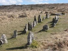
Scorhill Stone Circle
Prehistoric Dartmoor Walks: Dartmoor Site: Scorhill Stone Circle
OS Map: SX 65458 87399
HER: MDV6122
Megalithic Portal: 540
PMD: Scorhill Stone Circle
ShortName: SC Scorhill
Butler map: 38.8
Butler Vol 5: p.249 & Fig.175
DPD page: 146
Turner: G6
Notes: One of the most impressive stone circles on Dartmoor and one of the few that has not been restored. The circle consists of 23 granite slabs up to 2.5m high with a further 11 recumbent stones. The circle is not the largest in terms of diameter but it is the most striking circle on Dartmoor with some of the largest standing stones. See also, Legendary Dartmoor: Scorhill Stone Circle and HER MDV6122
Nearby sites: SX 65458 87399
Distance: 4.61km

Scorhill Reported Stone Row
Prehistoric Dartmoor Walks: Dartmoor Site: Scorhill Stone Circle
OS Map: SX 65485 87207
HER: MDV130497
Megalithic Portal: 25238
PMD: Scorhill Stone Row
ShortName: SR Scorhill
Butler map: 38.8
Butler Vol 5: p.172 & Fig.112
DPD page: 146
Notes: N. Teign. Claimed by Butler.See also Butler Vol 5 p. 249 fig. 175. Possible stone row near long cairn south-east of the Scorhill stone circle recorded by Butler (1991), although Gerrard was not convinced during Monument Protection Programme visit in 1998 and was not included in scheduling. Site visit in 2021 recorded potential row.. Visited by author on 06/02/2025 and the feature can be seen but currently looks like stones that may have been disturbed, tumbled, from the cairn that happen to form a short linear features. Changed entry from stone row to reported stone row as I'm inclined to agree with Gerrard.
Nearby sites: SX 65485 87207
Distance: 4.59km
Scorhill Circle Standing Stone
Prehistoric Dartmoor Walks: Dartmoor Site: Scorhill Stone Circle
OS Map: SX 6546 8738
HER: MDV6122
Megalithic Portal: 540
PMD: Scorhill Stone Circle
ShortName: SS Scorhill
Butler map: 38.8
DPD page: 146
Notes: Largest stone in the Scorhill Circle. In strict terms this would not typically be classified as a "standing stone" as it is a member of the stone circle. It is the largest stone in a Dartmoor stone circle at 8 feet 2 inches tall.
Nearby sites: SX 6546 8738
Distance: 4.61km
Scorhill N Reported Stone Row
OS Map: SX 6574 8782
HER: MDV6189
Megalithic Portal: 25238
ShortName: SR:ScorhillN
Notes: HER: (1950) Stone row. SX 65628794 to SX 65748782. (09/07/1974) There is no alignment of stones in this area of moorland which can be considered other than natural. It is doubtful if the alleged stone row was ever seen by Crawford. The information most probably came from H H Breton, an unreliable correspondent of c 1925.
Nearby sites: SX 6574 8782
Distance: 4.61km
Shilstone Common (DRE 1a) Cairn Circle
Prehistoric Dartmoor Walks: Dartmoor Site: Shilstone Common & Spinsters' Rock
OS Map: SX 699 908
HER: MDV7010
Megalithic Portal: 44557
The Stone Rows of GB: Spinsters Rock
PMD: Spinster's Rock Cairns and Stone Rows
Alternate name: Shilstone Common 1 Cairn Circle
ShortName: CC:Shilstone A
Butler Vol 5: p.218
Grinsell: B:DRE 1a
Notes: Former remains on Shilstone Common near Spinsters rock. Remains no longer visible. Possibly sketched by Rev. John Swete in 1789. Site controversially mapped by Rev. William Grey in 1838 and published by Ormerod in 1872. Site dismissed by R.H. Worth but probable cairn remains found during field excavations by Major F.C. Tyler in 1930. For a reappraisal of Tyler's report see coverage on Prehistoric Dartmoor Walks.
Nearby sites: SX 699 908
Distance: 3.26km
Shilstone Common (DRE 1b) Cairn Circle
Prehistoric Dartmoor Walks: Dartmoor Site: Shilstone Common & Spinsters' Rock
OS Map: SX 6995 9080
HER: MDV7010
Megalithic Portal: 44557
Alternate name: Shilstone Common 2 Cairn Circle
ShortName: CC:Shilstone B
Butler Vol 5: p.218
Grinsell: B:DRE 1b
Notes: Former remains on Shilstone Common near Spinsters rock. See Site 95 notes (B:DRE 1a)
Nearby sites: SX 6995 9080
Distance: 3.26km
Shilstone Common (DRE 1c) Cairn Circle
Prehistoric Dartmoor Walks: Dartmoor Site: Shilstone Common & Spinsters' Rock
OS Map: SX 7000 9055
HER: MDV7010
Megalithic Portal: 44557
Alternate name: Shilstone Common 3 Cairn Circle
ShortName: CC:Shilstone C
Butler Vol 5: p.218
Grinsell: B:DRE 1c
Notes: Former remains on Shilstone Common near Spinsters rock. See Site 95 notes (B:DRE 1a)
Nearby sites: SX 7000 9055
Distance: 3.00km
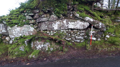
Shilstone Lane Reported Cairn
OS Map: SX 65955 90139
ShortName: CN-Shilstone
Notes: This record arose from a posting by Clive Darke on a Dartmoor Facebook forum. Clive posted a photo of this feature on the side of the road and asked whether it could perhaps be a re-used menhir in a Devon wall.
Nearby sites: SX 65955 90139
Distance: 4.86km
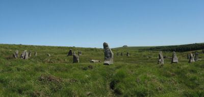
Shovel Down Ceremonial Complex
Prehistoric Dartmoor Walks: Dartmoor Site: Shovel Down Ceremonial Complex
OS Map: SX 6597 8596
Megalithic Portal: 10387
PMD: Shovel Down
ShortName: CX Shovel Down
Butler map: 36.6
DPD page: 139
Notes: Ceremonial complex including multiple stone rows and a small stone circle. Lethbridge pp.139-145. Interesting old sketches on the RAMM website: Emanuel Jeffery sketches of Shovel Down stone rows (1839) and Emanuel Jeffery sketch of Stone Row to Shovel Down Long Stone (1839)
Nearby sites: SX 6597 8596
Distance: 4.39km

Shovel Down Settlement
OS Map: SX 658 859
HER: MDV6163
Megalithic Portal: 10386
ShortName: ST ShovelDown
Butler map: 36.4
Nearby sites: SX 658 859
Distance: 4.57km
Shovel Down Stone Circle
Prehistoric Dartmoor Walks: Dartmoor Site: Shovel Down Ceremonial Complex
OS Map: SX 65829 86196
HER: MDV29944
Megalithic Portal: 1259
PMD: Shovel Down Stone Circle
ShortName: SC Shovel Down
Butler map: 36.6
DPD page: 139
Turner: G15
Notes: "The remains of an alleged stone circle lie on the gentle NE facing slope of Shovel Down 200m SW of Batworthy Corner. Three upright stones, between 0.3m and 0.75m high, are visible. The two close-set NE stones display smaller packing stones in the erosion hollows at their bases. The third stone is partly obscured by the bank of the South Hill Leat (SX 68 SW 97). It is possible that these stones constitute the remains of a stone circle however, no such feature is noted in the antiquarian records so it must remain a doubtful site". In fact a sketch of the Shovel Down rows made by Wilkinson in 1860 marks and illustrates "stones" at the location of the stone circle. For a photo, see Megalithic Portal: Shovel Down NW stone circle. Lethbridge pp.139-145, diagram p.139.
Nearby sites: SX 65829 86196
Distance: 4.45km
Shovel Down Cist
Prehistoric Dartmoor Walks: Dartmoor Site: Shovel Down Ceremonial Complex
OS Map: SX 65993 85924
HER: MDV6182
Megalithic Portal: 28953
PMD: Shovel Down
Alternate name: Shoveldown Rows 4 Cist
ShortName: CT Shovel Down
Butler map: 36.7
Butler Vol 5: p.223 & Fig.155
Grinsell: CHA 1
Notes: Robbed cist no longer visible. The Shovel down double row C (Worth Row C, Butler Rows 4) terminates at its southern end in a cairn - the cist has been robbed from the cairn. Visited 16/05/19 - a rectangular cist shaped hole can be clearly seen with reeds growing from it. No sign of a cist. Butler Shoveldown Rows 4 Vol. 2. Map 36.7 (diagram Vol. 5. p.223).
Nearby sites: SX 65993 85924
Distance: 4.39km
Shovel Down Fourfold Cairn Circle
Prehistoric Dartmoor Walks: Dartmoor Site: Shovel Down Ceremonial Complex
OS Map: SX 65958 86025
HER: MDV6158
Megalithic Portal: 3464
PMD: Fourfold Circle
Alternate name: Fourfold Circle Cairn Circle
ShortName: CC Shovel4Fold
Butler map: 36.7
DPD page: 143
Grinsell: GID 3
Turner: G31
Barrow Report: 56
Notes: "Fourfold Circle a sub-circular configuration of four apparently concentric stone rings. The outer ring has a diameter of 9m, the others have diameters of 6.4m, 4.7m and 2.4m respectively. The monument comprises 29 visible stones. Most are approximately 0.3m in height although they vary from 0.1-0.55m. The middle two rings define the bottom and top of the scarp of a small earthern cairn apparently an integral part of the monument. It is most pronounced on the E (downslope side). In the centre is a roughly sub-circular pit measuring 1.3m by 0.7m and 0.45m deep; it is probably the remains of a badly robbed cist. On the N side are two large fallen stones. When upright they may have served as a focal point for the end of the stone row " Lethbridge 139-145, diagram p.139.
Nearby sites: SX 65958 86025
Distance: 4.38km
Shovel Down Fourfold Circle Standing Stone
Prehistoric Dartmoor Walks: Dartmoor Site: Shovel Down Ceremonial Complex
OS Map: SX 65958 86033
HER: MDV6158
Megalithic Portal: 3464
PMD: Fourfold circle
Alternate name: Fourfold Circle Standing Stone
ShortName: SS Shovel Down
Butler map: 36.6
DPD page: 143
Barrow Report: 56
Notes: "The south end [of the double row] is aligned on a cairn 'Fourfold Circle' (SX 68 NE 17) and separated from it by two massive fallen stones, one 'needle-shaped' and similar to the 'Longstone' (SX 68 NE 39), southern terminal of stone row 'E'."
Nearby sites: SX 65958 86033
Distance: 4.38km
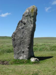
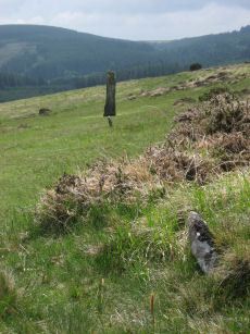
Shovel Down Long Stone Standing Stone
Prehistoric Dartmoor Walks: Dartmoor Site: Shovel Down Ceremonial Complex
OS Map: SX 66031 85683
HER: MDV6149
Megalithic Portal: 10378
PMD: Shovel Down
ShortName: SS Long Stone
Butler map: 36.6
Butler Vol 5: p.56 & Fig.34
DPD page: 140
Notes: The Long Stone has been used as a boundary stone but it appears to be the terminal stone for a Bronze Age stone row and it may be of a contemporary date. Grinsell [Folklore 1976]: At the beating of the bounds of Gidleigh Common, the first man to reach the Long Stone is (or was) given a money prize. Fielden 1933. The current author has been informed this tradition continues. See also, Legendary Dartmoor: The Shoveldon Longstone
Nearby sites: SX 66031 85683
Distance: 4.45km
Shoveldown 1 Stone Row
Prehistoric Dartmoor Walks: Dartmoor Site: Shovel Down Ceremonial Complex
OS Map: SX 66049 85707
HER: MDV6181
Megalithic Portal: 2128
The Stone Rows of GB: Shoveldown 1
PMD: Shovel Down H-K Stone Row
ShortName: SR ShovelRow 1
Butler map: 36.7.1
DPD page: 139
Notes: Worth Row G, Butler Row 1. This row is considered to be one long partially robbed row. Previously listed here as Shoveldown D-G-H-J now Shoveldown 1 after Butler and Gerrard.
Nearby sites: SX 66049 85707
Distance: 4.42km
Shoveldown 2 Stone Row
Prehistoric Dartmoor Walks: Dartmoor Site: Shovel Down Ceremonial Complex
OS Map: SX 65955 86026
HER: MDV6171
Megalithic Portal: 2129
The Stone Rows of GB: Shoveldown 2
PMD: Shovel Down A-B Stone Row
ShortName: SR ShovelRow 2
Butler map: 36.7.2
DPD page: 139
Notes: Worth Row A. Butler Rows 2.('B' SX 65968615 to SX 65968601) Double row to the east. Length 596 ft. Rows 3 ft 6in apart. Row is near Batworthy enclosure and has been much robbed; now just 12 pairs of stones and 15 single. Spacing of stones along the rows is around 6 ft. Two fallen stones next to the circle are much the largest in the row; one is 11 ft 6in, in length. and the other 7ft 4 in. The southern end of the row terminates in the Fourfold Circle (SX 68 NE 17). Lethbridge 139-145, diagram p.139.
Previously listed here as Shoveldown B now Shoveldown 2 after Butler and Gerrard.
Nearby sites: SX 65955 86026
Distance: 4.38km

Shoveldown 3 Stone Row
Prehistoric Dartmoor Walks: Dartmoor Site: Shovel Down Ceremonial Complex
OS Map: SX 65932 86073
HER: MDV6168
Megalithic Portal: 2130
The Stone Rows of GB: Shoveldown 3
PMD: Shovel Down D-E Stone Row
ShortName: SR ShovelRow 3
Butler map: 36.7.3
DPD page: 139
Notes: Worth Row E, Butler Rows 3. ('A' SX 65898616 to SX 65938605). Double row to the west of row B. Length 476 ft. Rows just over 4 ft apart but distance varies considerably along length. No special feature marks either end. Much robbed and single now along much of its length. Lethbridge 139-145, diagram p.139.
Previously listed here as Shoveldown A now Shoveldown 3 after Butler and Gerrard. Photo included here previously (taken in 2010) had misidentified Shoveldown 4 for this row.
Nearby sites: SX 65932 86073
Distance: 4.39km

Shoveldown 4 Stone Row
Prehistoric Dartmoor Walks: Dartmoor Site: Shovel Down Ceremonial Complex
OS Map: SX 65998 85903
HER: MDV14875
Megalithic Portal: 2127
The Stone Rows of GB: Shoveldown 4
PMD: Shovel Down C-F Stone Row
ShortName: SR ShovelRow 4
Butler map: 36.7.4
DPD page: 139
Notes: Worth Row C, Butler Rows 4. "('C' SX 65948601 to SX 65998590) A double row, 380 feet long, with an average distance of five feet between the rows. Most of the pairs of stones are complete and the southern end terminates in a barrow (SX 68 NE 34). No special feature marks the northern end."
Nearby sites: SX 65998 85903
Distance: 4.39km
Shoveldown 5 Stone Row
Prehistoric Dartmoor Walks: Dartmoor Site: Shovel Down Ceremonial Complex
OS Map: SX 66017 85840
HER: MDV6179
Megalithic Portal: 2126
The Stone Rows of GB: Shoveldown 5
PMD: Shovel Down G Stone Row
ShortName: SR ShovelRow 5
Butler map: 36.7.5
DPD page: 139
Notes: Worth Row G, Butler Rows 5 & 6 ('E')SX 66028581 to SX 66028567) A double row, 485 feet long with 3 1/4 feet between the rows which run almost due north and south, and terminates in a standing stone known as the Longstone (SX 68 NE 39). Fairly complete at the northern end but more ragged towards the south.
Nearby sites: SX 66017 85840
Distance: 4.39km
Shoveldown 6 Stone Row
OS Map: SX 66024 85681
HER: MDV6148
The Stone Rows of GB: Shoveldown 6
PMD: Shovel Down South
ShortName: SR:ShovelRow 6
Butler map: 36.7.6
Notes: Previously listed here as Shoveldown Longstone to Three Boys Stone Row now Shoveldown 6 after Butler and Gerrard.
Nearby sites: SX 66024 85681
Distance: 4.45km
Shoveldown D Reported Stone Row
Prehistoric Dartmoor Walks: Dartmoor Site: Shovel Down Ceremonial Complex
OS Map: SX 66040 85680
HER: MDV6145
Megalithic Portal: 2128
The Stone Rows of GB: Shoveldown 1
PMD: Shovel Down H-K Stone Row
ShortName: SR:ShovelRow D
Butler map: 36.7.1
DPD page: 139
Notes: Worth Row D, Butler Row 1. This row is considered to be one long partially robbed row - previously listed as four separate rows.
Nearby sites: SX 66040 85680
Distance: 4.44km
Shoveldown H Reported Stone Row
Prehistoric Dartmoor Walks: Dartmoor Site: Shovel Down Ceremonial Complex
OS Map: SX 65990 85950
HER: MDV14881
Megalithic Portal: 2128
The Stone Rows of GB: Shoveldown 1
PMD: Shovel Down H-K Stone Row
ShortName: SR:ShovelRow H
Butler map: 36.7.1
DPD page: 139
Notes: Worth Row H, Butler Row 1. This row is considered to be one long partially robbed row - previously listed as four separate rows.
Nearby sites: SX 65990 85950
Distance: 4.38km
Shoveldown J Reported Stone Row
Prehistoric Dartmoor Walks: Dartmoor Site: Shovel Down Ceremonial Complex
OS Map: SX 65980 86030
HER: MDV14882
Megalithic Portal: 2128
The Stone Rows of GB: Shoveldown 1
PMD: Shovel Down H-K Stone Row
ShortName: SR:ShovelRow J
Butler map: 36.7.1
DPD page: 139
Notes: Worth Row D, Butler Row 1. This row is considered to be one long partially robbed row - previously listed as four separate rows.
Nearby sites: SX 65980 86030
Distance: 4.36km
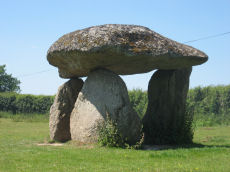
Spinsters Rock Chambered Tomb
Prehistoric Dartmoor Walks: Dartmoor Site: Spinsters' Rock
OS Map: SX 70098 90789
HER: MDV8440
Megalithic Portal: 149
PMD: Spinsters Rock
ShortName: NT Spinsters
Butler Vol 5: p.155
DPD page: 150
Grinsell: A:DREW 1
Barrow Report: 56
Notes: Chambered tomb restored in 1862. No evidence to confirm or deny the existence of an original mound survives. The remains of the chamber consist of three granite orthostats 6 to 9 1/2 feet high which support a large capstone 14 1/2 feet long by 10 feet wide. No trace of any mound survives. It is associated with the nearby stones thought to have been circles and alignments (SX 69 SE 25) (see Shilstone Common & Spinster's Rock page).
Nearby sites: SX 70098 90789
Distance: 3.24km
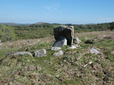
Thornworthy Cist
OS Map: SX 66746 84348
HER: MDV6613
Megalithic Portal: 15453
PMD: Thornworthy
ShortName: CT Thornworthy
Butler map: 35.22
Butler Vol 5: p.64 & Fig.42
DPD page: 137
Grinsell: CHA 3
Turner: E39
Barrow Report: 16 21 56
Notes: Butler Vol. 2. Map 35.22 (p.169, photo on p.136, diagram Vol. 5. p.64).Originally there was a second slightly smaller cist. This was removed after the excavation and re-erected at Torquay Museum. It is now at the High Moorland Visitor Centre at Princetown. See also: Thornworthy 2 Cist
Nearby sites: SX 66746 84348
Distance: 4.61km

Thornworthy Reported Stone Circle
OS Map: SX 65930 85035
ShortName: SC Thornworthy
Notes: Possible stone circle at Thornworthy reported by Sam Goodwin on a Facebook posting. The HER entry MDV6666 perhaps relates to this feature, a discounted reported stone row.
Nearby sites: SX 65930 85035
Distance: 4.84km

Thornworthy Reported Stone Row
OS Map: SX 66375 85001
HER: MDV6666
ShortName: SR Thornworthy
Notes: HER: A series of large stones set into a prominent field bank of a field system. It was alleged to be a stone row but this is thought unlikely. OS(1978): (SX 664850 to SX 663849) 'Stone Row' (NR) (1971 OS map).(10/02/1978) This recent publication entry (not on OS 25" 1904 or OS 6" 1961) is not a stone row but refers to some large stones set at irregular intervals along the course of a prominent field bank of a field system oriented on Thornworthy Tor (SX 68 NE146). The author located this feature on 03/03/2025 with Steve Szypko and we concluded this is regular stones in a reave, most probably prehistoric, but not a stone row.
Nearby sites: SX 66375 85001
Distance: 4.48km

Thornworthy Corner (N) Cist
OS Map: SX 66113 85468
HER: MDV6183
Megalithic Portal: 45776
PMD: Downhill from Three Boys
Alternate name: Thornworthy Corner N. Cist
ShortName: CT Thornwort N
Butler map: 36.7
Grinsell: CHA 2
Notes: "Recorded as a cist by Worth (1932), based on the one remaining stone. 1991 survey thought it more likely the result of stone clearance for the nearby newtake wall" Butler Vol. 2. Map 36.7.
Nearby sites: SX 66113 85468
Distance: 4.47km
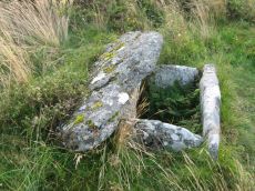
Three Boys Standing Stone
OS Map: SX 66028 85486
HER: MDV6180
Megalithic Portal: 10369
The Stone Rows of GB: Shoveldown 6
PMD: Three Boys
ShortName: SS Three Boys
Butler map: 36.6
Notes: Terminal for stone row - one of 3 stones. 3 standing stones, of which only one remains; sometimes claimed as remains of burial chamber. This record has two entries, this one as a standing stone as widely reported, but also as reported cairn or tomb, see Three Boys Reported Cairn, SiteID=1268
Nearby sites: SX 66028 85486
Distance: 4.53km
Three Boys Reported Cairn
OS Map: SX 66028 85486
HER: MDV6180
The Stone Rows of GB: Shoveldown 6
PMD: Three Boys
ShortName: CT-Three Boy1
Butler map: 36.7
Grinsell: LYD 9a
Notes: 3 standing stones, of which only one remains; sometimes claimed as remains of burial chamber.This record has two entries, listed as standing stone, see Three Boys Reported Cairn, SiteID=20
Nearby sites: SX 66028 85486
Distance: 4.53km

Yardworthy Stone Row
OS Map: SX 67605 84395
HER: MDV61337
Megalithic Portal: 6333471
The Stone Rows of GB: Yardworthy
PMD: Yardworthy
ShortName: SR Yardworthy
Notes: Quinnell quoted on HER: Stone row in Yardworthy Newtake, an area of rough pasture that has since undergone some stone clearance. Apparently the remains of a double row it starts 3.0 metres from a low barrow at SX67608438 and extends to the north-east for 7.0 metres. The north-west side consists of four stones, 2.0 to 2.5 metres apart. The south-eastern side about 1.4 metres distant has only one stone and two turf humps which may conceal others. Visible stones are barely 0.1 metres high. Immediately beyond the north-east end is a hollow or stone pit about 4.0 by 2.0 metres diameter. This, and clearance in the area may have destroyed any continuation.
Nearby sites: SX 67605 84395
Distance: 4.00km