
Shoveldown 5 Stone Row
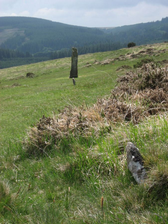
Photo taken on 06-06-2010
Database entries
PDW coverage: Dartmoor Site: Shovel Down Ceremonial Complex
OS Map: SX 66017 85840
OS Source: SRGB
HER: MDV6179
Megalithic Portal: 2126
The Stone Rows of GB: Shoveldown 5
PMD: Shovel Down G Stone Row
Alternate name: Shoveldown 5
Short Name: SR ShovelRow 5
Butler map: 36.7.5
DPD page: 139
Exist: Yes
Record: Unique
Record Source: PDW
Hut Class: No
Dimensions (m): 148
Lidar: SX 66017 85840
Guide Map: 13
Nearest Bus Stop (Minor): Wonson Telephone Box (5.2 km) [Route: 670]
Nearest Bus Stop (Major): Chagford The Square (4.4 km) [Route: 173,178,671]
Nearby sites: SX 66017 85840
Notes
Worth Row G, Butler Rows 5 & 6 ('E')SX 66028581 to SX 66028567) A double row, 485 feet long with 3 1/4 feet between the rows which run almost due north and south, and terminates in a standing stone known as the Longstone (SX 68 NE 39). Fairly complete at the northern end but more ragged towards the south.('F' SX66028567 to SX 66038549) A double row continuing on almost the same alignment as ('E'), 555 feet long and terminating in a single standing stone, the sole survivor of the Three Boys (SX 68 NE 40). Only a few set stones survive but Ormerod (a) states that in 1858 the pits left by the removal of the other stones of the double row could still be seen.
Lethbridge 139-145, diagram p.139.
Previously listed here as Shoveldown E-F now Shoveldown 5 after Butler and Gerrard.
References
These are selected references with an emphasis on out of copyright sources linked as PDFs. For more detailed references try any linked HER or PMD record above.
- Baring-Gould, Sabine, A Book of Dartmoor, (2002)
- Bate, C Spence, On the Prehistoric Antiquities of Dartmoor, T.D.A. Vol.4 pp.491-516 (1871)
- Butler, Jeremy, Dartmoor Atlas of Antiquities, vol.2: The North, (1991)
- Croker, J. G., A guide to the eastern escarpment of Dartmoor, (1851)
- Emmett, D.D., Stone rows: the traditional view reconsidered, D.A.S.P. No.37 pp.94-114 (1979)
- Fox, Aileen, Cairns and stone alignments on Shovel Down, Archaeological Journal Vol 114. pp.155-158 (1957)
- Lethbridge, William D., Discover Preshistoric Dartmoor, (2015)
- Lukis, W.C, Report on the Monuments of Dartmoor, Proceeding of the Society of Antiquaries Vol.8 (1881)
- Ormerod, George Wareing, On some British and druidical remains in the parishes of Chagford and Gidleigh, T.P.I. Vol.1 pp. 20-4 (1858)
- Ormerod, George Wareing, Archaeological memoirs relating to the East of Dartmoor, (1876)
- Page, John Lloyd Warden, An Exploration of Dartmoor and its Antiquities, with some account of its borders, (1889)
- Rowe, Samuel, A Perambulation of Dartmoor (1st Edition), (1848)
- Wilkinson J. Gardner, The Rock-basins of Dartmoor, and some British Remains in England, Journal Brit. Arch. Assoc. xvi. pp.101-132. (1860)
- Worth, R. Hansford, The Prehistoric Monuments of Scorhill, Buttern Hill, and Shuggledown (Shoveldown), T.D.A. Vol.64 pp.280-287 (1932)
- Worth, R. Hansford, The Stone Rows of Dartmoor Part 1, T.D.A. Vol.78 pp.285-316 (1946)