
Shilstone Lane Reported Cairn
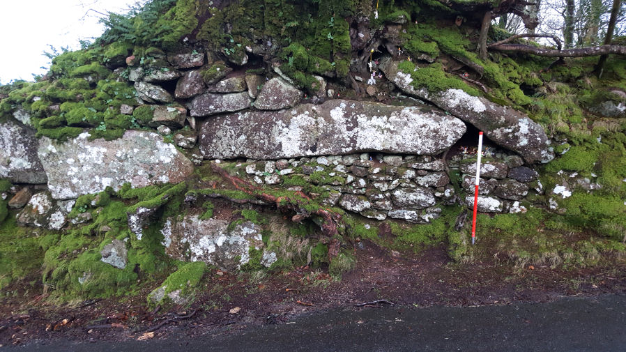
Photo taken on 27-01-2021
Database entries
OS Map: SX 65955 90139
OS Source: Google
Alternate name: Shilstone Lane
Short Name: CN-Shilstone
Exist: Yes
Record: Unique
Record Source: PDW
Hut Class: No
Cist Class: Maybe
Cairn Class: Maybe
Lidar: SX 65955 90139
Guide Map: 8
Nearest Bus Stop (Minor): Throwleigh Cross (1.4 km) [Route: 670]
Nearest Bus Stop (Major): Ramsley (3.3 km) [Route: 670,671,6A]
Nearby sites: SX 65955 90139
Notes
This record arose from a posting by Clive Darke on a Dartmoor Facebook forum. Clive posted a photo of this feature on the side of the road and asked whether it could perhaps be a re-used menhir in a Devon wall.Alan Endacott observed that it is on Shilstone Lane and Shilstone is a place name often associated with dolmens such as Shilstone common by Spinsters Rock near Drewsteignton. There are also other large slabs that could conceivably be remains of a destroyed site in the wall. The location of this feature is the side of the road between Shilstone Tor and Shilstone Farm. This particular stone is in fact a large slab that goes back into the bank and as such could perhaps have been a capstone. This combination of place name suggesting a long lost dolmen and possible remains is reminiscent of another site called Shilstone near Widecombe, see Chittleford Hill Reported Cairn. That location was registered on the HER and NMR as a "Possible site of a Neolithic barrow found in the field walls by the roadside [...] A very large orthostat, or shiner (sic), standing here which may have been a capstone. Nearby fields called 'Shelstone Lay' point to the existence of a cromlech. Also the walls of the field contain a large number of very large slabs and pillar-like stones such as might have formed a megalthic tomb". That description could almost apply to this record. The author would like to thank Clive Darke and Alan Endacott for the information behind this record. The photo was kindly supplied by Alan and copyright remains with him.
Breton p.57 At the next fork of the road there is a farm whose name is Langstone, indicates that a menhir or longstone once stood there. There is a road which turns to the left from Throwleigh Church which leads to a farm named Shilstone. Shilstone or Shelf Stone, was the name for a cromlech. One of these monuments formerly stood near by.
References
These are selected references with an emphasis on out of copyright sources linked as PDFs. For more detailed references try any linked HER or PMD record above.
- Breton, Henry Hugh, The Heart of Dartmoor, (1926)