
Shovel Down Fourfold Cairn Circle
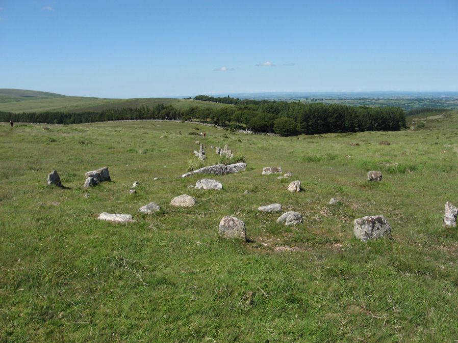
Photo taken on 26-06-2011
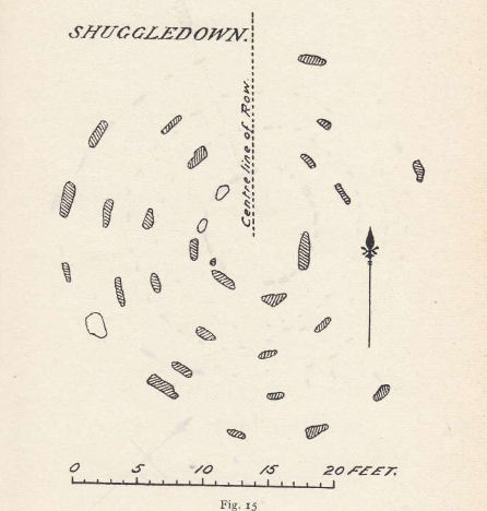
Plan by RHW. Barrow Report 56. TDA Vol.69 1937
Database entries
PDW coverage: Dartmoor Site: Shovel Down Ceremonial Complex
OS Map: SX 65958 86025
OS Source: Google
Butler OS: SX65958601
HER: MDV6158
Megalithic Portal: 3464
PMD: Fourfold Circle
Alternate name: Fourfold Circle
Short Name: CC Shovel4Fold
Butler map: 36.7
Grinsell: GIDLEIGH 3
Turner: G31
DPD page: 143
Exist: Yes
Record: Unique
Record Source: Butler
Hut Class: No
Cist Class: Maybe
Cairn Class: Yes
Barrow Report: 56
Dimensions (m): c.9.0
Lidar: SX 65958 86025
Guide Map: 13
Nearest Bus Stop (Minor): Wonson Telephone Box (4.9 km) [Route: 670]
Nearest Bus Stop (Major): Chagford The Square (4.4 km) [Route: 173,178,671]
Nearby sites: SX 65958 86025
Notes
"Fourfold Circle a sub-circular configuration of four apparently concentric stone rings. The outer ring has a diameter of 9m, the others have diameters of 6.4m, 4.7m and 2.4m respectively. The monument comprises 29 visible stones. Most are approximately 0.3m in height although they vary from 0.1-0.55m. The middle two rings define the bottom and top of the scarp of a small earthern cairn apparently an integral part of the monument. It is most pronounced on the E (downslope side). In the centre is a roughly sub-circular pit measuring 1.3m by 0.7m and 0.45m deep; it is probably the remains of a badly robbed cist. On the N side are two large fallen stones. When upright they may have served as a focal point for the end of the stone row " Lethbridge 139-145, diagram p.139.References
These are selected references with an emphasis on out of copyright sources linked as PDFs. For more detailed references try any linked HER or PMD record above.
- Bate, C Spence, On the Prehistoric Antiquities of Dartmoor, T.D.A. Vol.4 pp.491-516 (1871)
- Brailsford, J. W, Bronze Age Stone Monuments of Dartmoor, Antiquity Volume 12, Number 48 pp.444-63 (1938)
- Butler, Jeremy, Dartmoor Atlas of Antiquities, vol.2: The North, (1991)
- Fox, Aileen, Cairns and stone alignments on Shovel Down, Archaeological Journal Vol 114. pp.155-158 (1957)
- Grinsell, L.V., Dartmoor Barrows, Devon Archaeological Society Proceedings No.36 (1978)
- Lethbridge, William D., Discover Preshistoric Dartmoor, (2015)
- Ormerod, George Wareing, On some British and druidical remains in the parishes of Chagford and Gidleigh, T.P.I. Vol.1 pp. 20-4 (1858)
- Ormerod, George Wareing, Archaeological memoirs relating to the East of Dartmoor, (1876)
- Robinson, Rosmary and Greeves, T. A. P., Two Unrecorded Prehistoric Multiple Stone Rings, Glasscombe, Ugborough, South Dartmoor, D.A.S.P. No.39 pp.33-66 (1981)
- Robinson, Rosmary and Cosford, Judith, Dartmoor multiple stone circles, D.A.S.P. No.44 pp.166-170 (1986)
- Turner, J.R., Ring Cairns, stone circles and related monuments on Dartmoor, D.A.S.P. No.48 pp.27-86 (1990)
- Wilkinson J. Gardner, The Rock-basins of Dartmoor, and some British Remains in England, Journal Brit. Arch. Assoc. xvi. pp.101-132. (1860)
- Worth, R. Hansford, The Prehistoric Monuments of Scorhill, Buttern Hill, and Shuggledown (Shoveldown), T.D.A. Vol.64 pp.280-287 (1932)
- Worth, R. Hansford, Barrow Report 56, T.D.A. Vol.69 pp.75-109 (1937)
- Worth, R. Hansford, The Dartmoor Menhirs, T.D.A. Vol.72 pp.191-200 (1940)
- Worth, R. Hansford, Retaining circles associated with stone rows Dartmoor, T.D.A. Vol.73 pp.227-38 (1941)