
Prehistoric sites within 3km of SX 62500 69000
Guidance for walkers: The monuments featured in this database are archaeological treasures and need to be protected and preserved - please do not disturb any sites. Please check access and firing times before visiting sites, not all sites listed are on open access land. Firing ranges and boundaries of open access areas are marked on the OL28 OS Dartmoor Explorer map. Please stick to the country code and consider giving support to the numerous agencies that help to keep Dartmoor a fabulous natural and historic environment!
About the database listings: In all listings clicking on the photo or the site name will open a page for the site with a larger photo and further details from the database. The database now has over 6680 records covering nearly all publicly listed sites on Dartmoor including around 4800 round houses. This level of detail is of interest to archaeologists but tends to swamp listings of sites more likely to be of interest for walkers. For this reason, the listings default to around 550 core sites only. These are the stone circles, stone rows and the ring cairns listed by Turner. The default search radius is 2 km. The controls below the map can be used to start a new search by entering a 6- or 8-digit reference (without the prefix "SX"). The search radius can be specified and you can add incremental Display layers of detail on top of the core sites. If using a more detailed layer you will need to decrease the search radius to avoid getting hundreds of search results.
- Core sites Default listing of core sites consisting of stone circles & rows and some of the major ring cairns.
- Plus cairns adds approx. 1000 cairns and other minor sites not included in the core listings but excluding round houses.
- Plus round houses adds approx. 4800 round houses.
- Plus non-sites adds in the records for sites that no longer exist or are not prehistoric sites.
- Plus duplicates adds records excluded as duplicates. Those maybe duplicate records in external listings (e.g. the Historic Environment Records). For example, some sites have been identified as cairns in some listings and interpreted as round houses in other listings and both records appear.
These listings have incorporated, matched up and merged all of the records from all of the major archaeological listings including: Worth, Grinsell, Turner, Butler, Bill Radcliffe, Sandy Gerrard, Megalithic Portal, the National Monument Records and the Historic Environment Records. The author would like to thank Bill, Sandy, the lovely people both at Megalithic Portal (especially Anne Tate who did an amazing job to link listings) and at ACE Archaeology for collaborative work over the years to synchronise and correct listings across the various websites which now interlink. A culmination of years of work the final merger of cairn records took 3 months of cross referencing in 2017 the result being a snapshot of the records at that time. This data has in turn been refined since by field work and research. The round house data was supplied by Sandy Gerrard. Grid references are in order of accuracy: from Google Earth satellite, if visible and found, from a Garmin GPS reading, if visited by the author and from the literature otherwise. Individual site pages will state the source of the grid reference and provide satellite imagery. If a site listing lacks a photo it has not yet been visited by the author in which case the grid reference is from the literature.
Currently the database only includes sites which can be represented by a grid reference. Reaves are not included as they require GIS shape technology which is beyond the current capability of this system. To see the sources for the records, look at the tables on the resources menu. The database listings can also be viewed on a Google map and downloaded as GPS datasets for Garmin devices.
Corrections, or any feedback or suggestions are very welcome, email: info@dartmoorwalks.org.uk.
NOTE: Clicking on the icons for each monument in the map will give the name of the site. You can zoom in and out and drag the map around.
List of sites within 3km of SX 62500 69000
Langcombe Foot Round House
OS Map: SX 60154 67180
HER: MDV5116
ShortName: HT:Langcombe7
Nearby sites: SX 60154 67180
Distance: 2.97km
Royal Hill E Round House
OS Map: SX 63042 71941
HER: MDV54418
ShortName: HT:Royal Hil2
Nearby sites: SX 63042 71941
Distance: 2.99km
Royal Hill E Round House
OS Map: SX 63059 71922
HER: MDV54417
ShortName: HT:Royal Hil3
Nearby sites: SX 63059 71922
Distance: 2.97km
Royal Hill S Round House
OS Map: SX 62397 71304
HER: MDV12965
ShortName: HT:Royal Hil5
Nearby sites: SX 62397 71304
Distance: 2.31km
Royal Hill S Round House
OS Map: SX 62406 71341
HER: MDV12965
ShortName: HT:Royal Hil6
Nearby sites: SX 62406 71341
Distance: 2.34km
Royal Hill S Round House
OS Map: SX 62412 71293
HER: MDV12965
ShortName: HT:Royal Hil7
Nearby sites: SX 62412 71293
Distance: 2.29km
Ter Hill NW Round House
OS Map: SX 63248 71624
HER: MDV6370
ShortName: HT:Ter Hill 41
Nearby sites: SX 63248 71624
Distance: 2.73km
Royal Hill S Round House
OS Map: SX 62426 71344
HER: MDV12965
ShortName: HT:Royal Hil8
Nearby sites: SX 62426 71344
Distance: 2.35km
Ter Hill NW Round House
OS Map: SX 63284 71640
HER: MDV6370
ShortName: HT:Ter Hill 42
Nearby sites: SX 63284 71640
Distance: 2.75km
Royal Hill S Round House
OS Map: SX 62428 71312
HER: MDV12965
ShortName: HT:Royal Hil9
Nearby sites: SX 62428 71312
Distance: 2.31km
Ter Hill NW Round House
OS Map: SX 63293 71633
HER: MDV6370
ShortName: HT:Ter Hill 43
Nearby sites: SX 63293 71633
Distance: 2.75km
Royal Hill S Round House
OS Map: SX 62449 71356
HER: MDV12965
ShortName: HT:Royal Hil10
Nearby sites: SX 62449 71356
Distance: 2.36km
Royal Hill S Round House
OS Map: SX 62473 71325
HER: MDV12965
ShortName: HT:Royal Hil11
Nearby sites: SX 62473 71325
Distance: 2.33km
Langcombe Head 1 Reported Cairn
OS Map: SX 6199 6630
HER: MDV13173
ShortName: CN?Langcombe1
Butler map: 50.3.12
Grinsell: COR 24
Notes: Probing confirms that the mound is a peat stack.
Nearby sites: SX 6199 6630
Distance: 2.75km
Royal Hill S Round House
OS Map: SX 62473 71315
HER: MDV12965
ShortName: HT:Royal Hil12
Nearby sites: SX 62473 71315
Distance: 2.32km
Royal Hill S Round House
OS Map: SX 62468 71363
HER: MDV12965
ShortName: HT:Royal Hil13
Nearby sites: SX 62468 71363
Distance: 2.36km
Royal Hill SE Round House
OS Map: SX 6294 7167
HER: MDV26071
ShortName: HT:Royal Hil14
Nearby sites: SX 6294 7167
Distance: 2.71km
Great Gnats' Head 2 Reported Cist
OS Map: SX 6119 6803
HER: MDV5092
ShortName: CN:GreatGnats2
Butler map: 50.5.2
Grinsell: SHA 1a
Barrow Report: 20
Notes: "Round cairn adjacent to cist. Cairn lies 4m s of the cist and survives as a 4m diam and 0.2m high mound. This cairn was investigated in 1901 and found to cover a circular, carefully paved area lying on top of a large flat stone."
Nearby sites: SX 6119 6803
Distance: 1.63km
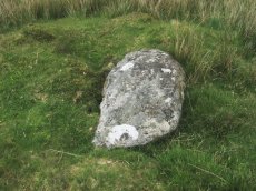
Fox Tor Mire Cairn
OS Map: SX 618 701
HER: MDV12968
ShortName: CN:Fox Tor M1
Grinsell: LYD 95a
Notes: On a gentle N slope is a peaty mound 3.5m in diameter and 0.3m high. On its W perimeter are two large earthfast stone 0.6m high. Several smaller ones protude through the peat near the centre indicating a stone content.
Nearby sites: SX 618 701
Distance: 1.30km
Great Gnats' Head 3 Cairn
OS Map: SX 6128 6805
HER: MDV57383
ShortName: CN:GreatGnats3
Butler map: 50.5.3
Notes: HER entry does not match the size of the cairn listed by Butler.
Nearby sites: SX 6128 6805
Distance: 1.55km
Ter Hill N.W.3 Reported Cairn
OS Map: SX 6289 7109
HER: MDV12969
ShortName: CN:Ter Hill 3
Grinsell: LYD 98a
Notes: A low turf-covered mound situated at SX 62887108 is probably the feature noted by both Fox and Grinsell. It lies in tall cotton grass on a south-west facing peat-covered hiislope in an area covered by low swellings, gullies and a marked accumulation of surface peat.
Nearby sites: SX 6289 7109
Distance: 2.13km
Deadman's Bottom (W) Reported Cairn
OS Map: SX 6070 6697
HER: MDV57422
ShortName: CN:Deadmans W
Butler map: 50.1
Grinsell: SHA 5
Turner: D27
Notes: Hut circle. Butler Circle 2 / 3
UPDATE 31/12/2022
The following 3 records have been merged into one with the first retained and the other two deleted, this corresponds with maintenance done on the HER (MDV48861 and MDV57422 have been deleted). The NGRs have been reset to match MDV57422.
1. SiteID=2587(was MDV48861) now set to HER=MDV57422
2. SiteID=4174 (was MDV57441) deleted
3. SiteID=4169 (was MDV57422) deleted
Nearby sites: SX 6070 6697
Distance: 2.71km
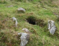
Deadman's Bottom (E) Cairn
Prehistoric Dartmoor Walks: Dartmoor Site: Guide to the Langcombe Brook & Deadman's Bottom Cists
OS Map: SX 60788 66893
HER: MDV5118
ShortName: CN Deadmans E
Butler map: 50.1
Grinsell: SHA 6
Turner: D28
Notes: Worth considered this to be a cairn. It was excavated and it was found to be paved with reddened earth showing great fires had been present. Butler Circle 1. Butler suggests it could just have been a hut circle and the fires the consequence of domestic activity. He points out the presence of a settlement wall. However it is also very close to a pair of cists and could be a cairn. We are listing as a cairn although Butler could of course be right. This "circle" can be clearly seen in the Google satellite images. Previously listed at SX 60798 66895 (Garmin reading?), presumed SX 60788 66893 from Google.
Nearby sites: SX 60788 66893
Distance: 2.71km
Deadman's Bottom 4 Reported Cairn
OS Map: SX 6061 6684
HER: MDV5131
ShortName: CN?Deadmans 4
Grinsell: SHA 9
Notes: Hut circle or cairn?
Nearby sites: SX 6061 6684
Distance: 2.87km
Deadman's Bottom 3 Reported Cairn
OS Map: SX 6059 6686
HER: MDV5130
ShortName: CN?Deadmans 3
Grinsell: SHA 9a
Notes: Hut circle or cairn?
Nearby sites: SX 6059 6686
Distance: 2.87km
Deadman's Bottom 2 Reported Cairn
OS Map: SX 6063 6683
HER: MDV20163
ShortName: CN?Deadmans 2
Grinsell: SHA 9b
Notes: Hut circle or cairn?
Nearby sites: SX 6063 6683
Distance: 2.86km
Newleycombe Lake Cairn
OS Map: SX 5963 6983
HER: MDV52393
ShortName: CN:Newleycombe
Nearby sites: SX 5963 6983
Distance: 2.99km
Little Gnats' Head Round House
OS Map: SX 60512 67320
HER: MDV55305
ShortName: HT:Little Gn1
Nearby sites: SX 60512 67320
Distance: 2.60km
Deadman's Bottom 7 (pos duplicate) Reported Cairn
OS Map: SX 6071 6697
HER: MDV57423
ShortName: CN:Deadmans 7
Nearby sites: SX 6071 6697
Distance: 2.71km
Deadman's Bottom 8 (pos duplicate) Reported Cairn
OS Map: SX 6065 6691
HER: MDV57434
ShortName: CN:Deadmans 8
Nearby sites: SX 6065 6691
Distance: 2.79km
Nun's Cross Farm Reported Cist
OS Map: SX 606 698
HER: MDV5156
PMD: Nun's Cross Farm
ShortName: CT?Nun's Cro1
Butler map: 64.6
Grinsell: LYD 108
Barrow Report: 14 16 21
Notes: Cist said to have been destroyed without record shortly before 1892. Worth 1892
Nearby sites: SX 606 698
Distance: 2.06km
Deadman's Bottom 9 (pos duplicate) Reported Cairn
OS Map: SX 6065 6689
HER: MDV57437
ShortName: CN:Deadmans 9
Nearby sites: SX 6065 6689
Distance: 2.81km
Green Hill N. Reported Cairn
OS Map: SX 637 688
HER: MDV19966
ShortName: CN?Green Hil2
Grinsell: LYD 101a
Notes: A cairn was alleged on the north of Green Hill but there is no field evidence to substantiate this
Nearby sites: SX 637 688
Distance: 1.22km
Deadman's Bottom 10 (duplicate) Reported Cairn
OS Map: SX 6064 6683
HER: MDV57440
ShortName: CN:Deadmans 10
Nearby sites: SX 6064 6683
Distance: 2.86km
Ter Hill N.W.4 Cairn
OS Map: SX 6382 7079
HER: MDV58864
ShortName: CN:Ter Hill 4
Nearby sites: SX 6382 7079
Distance: 2.22km
Crane Hill Reported Cairn
OS Map: SX 61882 68773
HER: MDV78136
ShortName: CN:Crane Hill
Nearby sites: SX 61882 68773
Distance: 0.66km
Royal Hill E.8 Cairn
OS Map: SX 6227 7130
HER: MDV78792
ShortName: CN?RoyalHill 8
Nearby sites: SX 6227 7130
Distance: 2.31km
Little Gnat's Head Reported Cairn
OS Map: SX 60845 67193
HER: MDV102713
ShortName: CN:LittleGnats
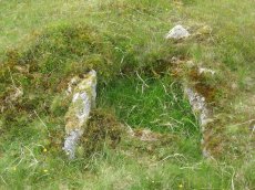
Notes: "Circular ring bank on Little Gnat's Head, between the River Plym and Deadman's Bottom. Overgrown with grass and peat, there is a 0.5 metre gap on the south-west side. The location is a likely one for a cairn, but the feature more closely resembles a hut circle, especially with a possible entrance gap to the south-west."
Nearby sites: SX 60845 67193
Distance: 2.45km
Fox Tor Girt Reported Cairn
OS Map: SX 63204 69910
HER: MDV103605
ShortName: CN?FoxTor Girt
Notes: A small cairn 130 metres east of Fox Tor Girt. It measures 2.6 metres in diameter and 0.6 metres high and is comprised of loose boulders roughly piled on large earthfast blocks.
Nearby sites: SX 63204 69910
Distance: 1.15km
Green Hill Clearance Cairn
OS Map: SX 6365 6774
HER: MDV28465
ShortName: CN?GreenHill2
Grinsell: B:LYD 101b
Notes: Mound 30m S of LYD 101 period doubtful. A cairn was alleged on Green Hill but field evidence revealed a small mound measuring 7.8m by 7.5m and 0.4m high and concluded that it is the remains of peat workings.
Nearby sites: SX 6365 6774
Distance: 1.71km
Deadman's Bottom 13 Reported Cist
OS Map: SX 608 668
HER: MDV5121
ShortName: CT:Deadmans 13
Notes: Duplicate: Record gives an account of the Deadman's Bottom North and South cists and the associated circles.
Nearby sites: SX 608 668
Distance: 2.78km
Eylesbarrow Cairn
OS Map: SX 59971 68587
HER: MDV4014
ShortName: CN Eylesbarr1
Butler map: 47.15
Grinsell: SHE 3
Barrow Report: 12
Notes: Southern of the 2 large cairns. Butler had SHE 2 - typo!
Nearby sites: SX 59971 68587
Distance: 2.56km
Eylesbarrow 1 Cairn
OS Map: SX 59958 68627
HER: MDV4031
ShortName: CN Eylesbarr3
Butler map: 47.15.1
Grinsell: WAL 33
Barrow Report: 12
Notes: Northern of the 2 large cairns
Nearby sites: SX 59958 68627
Distance: 2.57km
Eylesbarrow 2 Reported Cairn
OS Map: SX 5998 6858
ShortName: CN?Eylesbarr4
Butler map: 47.15.2
Notes: Butler: "Not unusually smaller cairns share the peaks withhe giants and two can be found east of th larger cairn (HER 4014) approcimately in line with the reave. Neither listed on HER.
Nearby sites: SX 5998 6858
Distance: 2.55km
Eylesbarrow 3 Reported Cairn
OS Map: SX 6005 6858
ShortName: CN?Eylesbarr5
Butler map: 47.15.3
Notes: Butler: "Not unusually smaller cairns share the peaks withhe giants and two can be found east of th larger cairn (HER 4014) approcimately in line with the reave. Neither listed on HER.
Nearby sites: SX 6005 6858
Distance: 2.49km
Lower Hartor Tor Round House
OS Map: SX 60218 67337
HER: MDV5117
ShortName: HT:Lower Har1
Nearby sites: SX 60218 67337
Distance: 2.82km
Lower Hartor Tor Round House
OS Map: SX 60268 67341
HER: MDV5117
ShortName: HT:Lower Har2
Nearby sites: SX 60268 67341
Distance: 2.78km
Lower Hartor Tor Round House
OS Map: SX 60238 67357
HER: MDV5117
ShortName: HT:Lower Har3
Nearby sites: SX 60238 67357
Distance: 2.80km
Lower Hartor Tor Round House
OS Map: SX 60247 67348
HER: MDV5117
ShortName: HT:Lower Har4
Nearby sites: SX 60247 67348
Distance: 2.79km
Goldsmith's Cross E.3 (duplicate) Reported Cairn
OS Map: SX 61709 70209
HER: MDV12964
ShortName: CN:Goldsmith4
Notes: Duplicate of 6343
Nearby sites: SX 61709 70209
Distance: 1.44km
Plym Ford Reported Cist
OS Map: SX 6116 6851
HER: MDV5094
PMD: Plym Ford
ShortName: CT?Plym Ford1
Notes: Alledged cist - Breton. A cist was alleged at this location but could not be found on the ground
Nearby sites: SX 6116 6851
Distance: 1.43km
Fox Tor Farm Round House
OS Map: SX 62729 71292
HER: MDV25568
ShortName: HT:Fox Tor F1
Nearby sites: SX 62729 71292
Distance: 2.30km
Fox Tor Farm Round House
OS Map: SX 62732 71332
HER: MDV25568
ShortName: HT:Fox Tor F2
Nearby sites: SX 62732 71332
Distance: 2.34km
Fox Tor Farm Round House
OS Map: SX 62734 71349
HER: MDV25568
ShortName: HT:Fox Tor F3
Nearby sites: SX 62734 71349
Distance: 2.36km
Langcombe Head 2 Cairn
OS Map: SX 6204 6630
HER: MDV13174
ShortName: CN:Langcombe2
Nearby sites: SX 6204 6630
Distance: 2.74km
Great Gnats' Head 5 Cairn
OS Map: SX 616 680
HER: MDV13176
ShortName: CN:GreatGnats5
Nearby sites: SX 616 680
Distance: 1.35km
Great Gnats' Head 5 (duplicate) Reported Cairn
OS Map: SX 616 681
HER: MDV13178
ShortName: CN:GreatGnats6
Notes: Probably a duplicate of HER 13176
Nearby sites: SX 616 681
Distance: 1.27km
Newleycombe Lake Head N Round House
OS Map: SX 59706 70003
HER: MDV3783
ShortName: HT:Newleycom8
Nearby sites: SX 59706 70003
Distance: 2.97km
Newleycombe Lake Head N Round House
OS Map: SX 59710 70012
HER: MDV3783
ShortName: HT:Newleycom9
Nearby sites: SX 59710 70012
Distance: 2.97km
Foxtor Cross N.E. of Cairn
OS Map: SX 6193 6988
HER: MDV5095
PMD: Fox Tor Mires S.
ShortName: CT?Foxtor Cr1
Notes: [Presumably Foxtor not Foxton] Cist 54.9 meters south east of white stone in the wall. Area was over grown with high heather in 1917-1918, but the heather was burnt in 1920 and the cist was quite plain with capstone by north east side. The south west stone had gone.No trace of this antiquity could be found in 1950.
Nearby sites: SX 6193 6988
Distance: 1.05km
Newleycombe Lake Head S Round House
OS Map: SX 59669 69824
HER: MDV3427
ShortName: HT:Newleycom10
Nearby sites: SX 59669 69824
Distance: 2.95km
Newleycombe Lake Head S Round House
OS Map: SX 59700 69798
HER: MDV3427
ShortName: HT:Newleycom11
Nearby sites: SX 59700 69798
Distance: 2.91km
Newleycombe Lake Head S Round House
OS Map: SX 59619 69806
HER: MDV3427
ShortName: HT:Newleycom12
Nearby sites: SX 59619 69806
Distance: 2.99km
Newleycombe Lake Head S Round House
OS Map: SX 59661 69774
HER: MDV3427
ShortName: HT:Newleycom15
Nearby sites: SX 59661 69774
Distance: 2.94km
Newleycombe Lake Head S Round House
OS Map: SX 59678 69825
HER: MDV3427
ShortName: HT:Newleycom16
Nearby sites: SX 59678 69825
Distance: 2.94km
Lower Hartor Tor Cairn
OS Map: SX 60174 67299
HER: MDV5082
ShortName: CN:Lower Har1
Butler map: 49.17
Grinsell: SHE 35
Nearby sites: SX 60174 67299
Distance: 2.88km
Newleycombe Lake Head S Round House
OS Map: SX 59636 69849
HER: MDV3427
ShortName: HT:Newleycom20
Nearby sites: SX 59636 69849
Distance: 2.99km
Newleycombe Lake Head S Round House
OS Map: SX 59704 69840
HER: MDV3427
ShortName: HT:Newleycom21
Nearby sites: SX 59704 69840
Distance: 2.92km
Newleycombe Lake Head S Round House
OS Map: SX 59679 69763
HER: MDV3427
ShortName: HT:Newleycom22
Nearby sites: SX 59679 69763
Distance: 2.92km
Plym Head Reported Cist
OS Map: SX 6177 6839
HER: MDV5093
PMD: Plym Head
ShortName: CNxPlym Head1
Notes: A cairn was alleged at this location could no trace of it could be revealed during field investigation. NMR: "Capstone 5 feet 8 inches by 5 feet 14 stones. Prostrate stones in circle, one over 8 feet high, one over 6 feet high, one over 3 feet high. Oriented 22 1/2o east of north. This is a little doubtful, the tinners might have made it."
Nearby sites: SX 6177 6839
Distance: 0.95km
Eylesbarrow (reported cist) Reported Cairn
OS Map: SX 59733 68119
HER: MDV66398
PMD: Narrator Brookhead S
ShortName: CT?Eylesbarr2
Notes: Doubtful. SX 59406820. The site of a possible cist lies on the lower SW flank of Eylesbarrow some 400m W of Eylesbarrow Mine.The feature is marked by a single upright slab 1.1m long 0.2m wide and 0.3m high resembling a sidestone adjacent to a second slab 1.4m long and 0.9m wide perhaps representing the coverstone.Both stones are earthfast and are surrounded by a cluster of smaller stones which could represent the remains of a cairn. The area surrounding these stones has been disturbed by later tin extraction activity and it is also possible that they are products of this activity.
Nearby sites: SX 59733 68119
Distance: 2.90km
Deadman's Bottom 5 (pos duplicate) Reported Cairn
OS Map: SX 6067 6696
HER: MDV22795
ShortName: CN:Deadmans 5
Notes: UPDATE 31/12/2022. This record was duplicated by HER record MDV57442 which has now been deleted (SiteID=4270, also deleted)
Nearby sites: SX 6067 6696
Distance: 2.74km
Langcombe Brook Round House
OS Map: SX 60795 66892
HER: MDV5118
ShortName: HT:Langcombe1
Notes: This round house is also listed as a cairn. This record has been marked as a duplicate. The actual site maybe a cairn, a round house or both see Deadman's Bottom (E) Cairn SiteID=2588.
Nearby sites: SX 60795 66892
Distance: 2.71km
Langcombe Brook Round House
OS Map: SX 60772 66901
HER: MDV57435
ShortName: HT:Langcombe2
Nearby sites: SX 60772 66901
Distance: 2.72km
Langcombe Brook Round House
OS Map: SX 60605 66860
ShortName: HT:Langcombe3
Nearby sites: SX 60605 66860
Distance: 2.86km
Langcombe Brook Round House
OS Map: SX 60603 66876
HER: MDV57432
ShortName: HT:Langcombe4
Nearby sites: SX 60603 66876
Distance: 2.85km
Langcombe Brook Round House
OS Map: SX 60585 66873
HER: MDV57433
ShortName: HT:Langcombe5
Nearby sites: SX 60585 66873
Distance: 2.86km
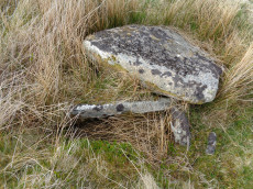
Calveslake Cist
Prehistoric Dartmoor Walks: Dartmoor Site: Guide to the Langcombe Brook & Deadman's Bottom Cists
OS Map: SX 60874 67551
HER: MDV5085
Megalithic Portal: 45660
PMD: Calveslake Tor
Alternate name: Calveslake Tor Cist
ShortName: CT Calveslak
Butler map: 50.4
DPD page: 43
Grinsell: SHA 3
Barrow Report: 12 19
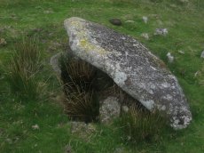
Notes: "A perfect, well constructed cist at Calveslake. Length, 3ft 7inches; width at north end,1ft 7 1/2 inches; at south end, 1ft 9inches, depth to floor, 2ft 7inches. An irregular shaped cover-stone overhangs the eastern end of the cist. The barrow in which the cist stands has a diameter of 18 feet." Lethbridge Calves Lake cist p.42-43, diagram p.42. Butler Calveslake Tor - Vol. 3. Map 50.4 (diagram p.154).
Nearby sites: SX 60874 67551
Distance: 2.18km
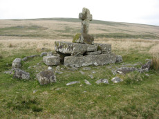
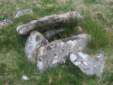
Childes Tomb Platform Cairn Circle and Cist
OS Map: SX 62577 70299
HER: MDV48907
Megalithic Portal: 15211
PMD: Childe's Tomb
ShortName: CT ChildesTomb
Butler map: 64.4
DPD page: 94
Grinsell: LYD 96
Turner: E33
Notes: "A much disturbed cairn, 9m in diameter and 0.3m high with a modern 'kerb' of blocks and slabs, 5.8m in diameter and 0.5m high, set upon the mound. At the centre is a well built cist 1.4m long, 0.5m wide and 0.6m deep. Over this is a two tier pedestal of eight well trimmed blocks, of three different lengths; a further half buried block lies S of the monument. Upon this is a replacement socket stone and cross, cut at Holne in 1885". Lethbridge diagram p.93, photo p.94. Butler Vol. 4. Map 64.4 (diagram p.220).
Nearby sites: SX 62577 70299
Distance: 1.30km
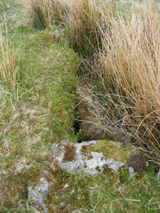
Deadman's Bottom Embanked Cairn Circle
Prehistoric Dartmoor Walks: Dartmoor Site: Guide to the Langcombe Brook & Deadman's Bottom Cists
OS Map: SX 60711 67027
HER: MDV12420
Megalithic Portal: 3194
Alternate name: Deadman's Bottom 1 Embanked Cairn Circle
ShortName: CC Deadmans 1
Turner: B1
Notes: "Turner identifies this site as an embanked stone circle; an annular bank of earth and/or stones with an inner edge of orthostats. Internal diam 16m with bank 0.8m wide and 0.3m high. The bank has been pushed out on the sse side and the stones lean outward (turner)." Turner B1.
Nearby sites: SX 60711 67027
Distance: 2.66km
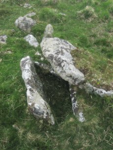
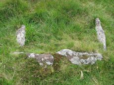
Deadman's Bottom, North Cist
Prehistoric Dartmoor Walks: Dartmoor Site: Guide to the Langcombe Brook & Deadman's Bottom Cists
OS Map: SX 60782 66900
HER: MDV5120
Megalithic Portal: 3194
PMD: Deadman's Bottom N 1
Alternate name: Langcombe Brook 2 Cist
ShortName: CT Deadmans N
Butler map: 50.3.2
DPD page: 44
Grinsell: SHA 7
Barrow Report: 12 19
Notes: "The remains of a cist lie on the northern slopes of Deadmans Bottom. The feature consists of a stone lined box, c.1m long and c. 0.4m wide, with a coverstone which has now slid to the north. The cist has collapsed in on itself. There is a turf covered stone spread to the south but little real evidence of an associated cairn." Lethbridge p.44 Langcombe Cist C - diagram p.43 Butler Langcombe Brook 2 (Cist 2) - Vol. 3. Map 50.3 (pp.148-54 general plan of Langcombe Brook cairns p.151, diagram of Deadmans Bottom cists p.149).
Nearby sites: SX 60782 66900
Distance: 2.71km
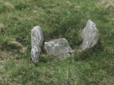
Deadman's Bottom, South Ring Setting Cairn and Cist
Prehistoric Dartmoor Walks: Dartmoor Site: Guide to the Langcombe Brook & Deadman's Bottom Cists
OS Map: SX 60788 66892
HER: MDV5119
Megalithic Portal: 3194
PMD: Deadman's Bottom N 2
Alternate name: Langcombe Brook 1 Ring Setting Cairn and Cist
ShortName: CT Deadmans S
Butler map: 50.3.1
DPD page: 45
Grinsell: SHA 8
Turner: D12
Barrow Report: 12 19
Notes: "Cairn consists of a stony mound, c 6.1m in diameter and c 0.5m high, contained by granite slabs some upright some fallen. The southern quadrant of the cairn has been disturbed. The remains of a very fine cist, box dimensions c. 0.8 x 0.7m internally, survives at its centre." One side slab and the cover-stone of the cist are missing although both could be slabs nearby. The cover-stone may be the large slab which lies to the south. Lethbridge p.45 Langcombe Cist D - diagram p.43 Dixon #7. Bar Rep. 19. Butler Langcombe Brook 1 (Cist 1) Vol. 3. Map 50.3 (pp.148-54 general plan of Langcombe Brook cairns p.151, diagram of Deadmans Bottom cists p.149).
Nearby sites: SX 60788 66892
Distance: 2.72km
Deadmans Bottom D Platform Cairn Circle and Cist
Prehistoric Dartmoor Walks: Dartmoor Site: Guide to the Langcombe Brook & Deadman's Bottom Cists
OS Map: SX 6096 6673
HER: MDV5086
Megalithic Portal: 45731
PMD: Deadman's Bottom S 10
Alternate name: Langcombe Brook 10 Platform Cairn Circle and Cist
ShortName: CT:Deadmans D
Butler map: 50.3.10
DPD page: 45
Grinsell: SHA 10
Turner: E44
Barrow Report: 53
Notes: "The cairn is 5m in diameter by 0.3m high with a retaining kerb on its northern side. The cist is 0.8m long b 0.7m wide." "Cist (listed as 'D' by Worth) found at Deadman's Bottom Langcombe, by Mr Button. Internal dimensions, length 3 feet 8 inches, width 2 feet. The stones are barely visible above grass level. The cover stone is missing." Lethbridge p.45 Langcombe Cist E - diagram p.43. Butler Langcombe Brook Cairn 10 - Vol. 3. Map 50.3 (pp.148-54 general plan of Langcombe Brook cairns p.151, diagram of Langcombe cists p.153).
Nearby sites: SX 6096 6673
Distance: 2.74km
Deadmans Bottom E Cist
Prehistoric Dartmoor Walks: Dartmoor Site: Guide to the Langcombe Brook & Deadman's Bottom Cists
OS Map: SX 60984 66714
HER: MDV5122
Megalithic Portal: 45732
PMD: Deadman's Bottom S 9
Alternate name: Langcombe Brook 9 Cist
ShortName: CT Deadmans E
Butler map: 50.3.9
DPD page: 45
Grinsell: SHA 11
Barrow Report: 53
Notes: "Cist (Listed as 'E' by Worth) found at Deadman's Bottom, Langcombe, by Mr. Button. Probable original dimensions, length 2ft 2 ins, width 1ft. 5ins. The stones barely show above the surface and the cover-stone is missing." ... "A well defined cairn 6.0m in diameter and 0.4m high with a cist in the top. This stone-lined cist measures 0.7m by 0.5m internally and 0.3 deep. Two of the side stones have fallen inwards." Lethbridge p.45 Langcombe Cist F - diagram p.43 Butler Langcombe Brook Cairn 9 - Vol. 3. Map 50.3 (pp.148-54 general plan of Langcombe Brook cairns p.151, diagram of Langcombe cists p.153).
Nearby sites: SX 60984 66714
Distance: 2.74km
Deadmans Bottom F Platform Cairn Circle and Cist
Prehistoric Dartmoor Walks: Dartmoor Site: Guide to the Langcombe Brook & Deadman's Bottom Cists
OS Map: SX 61201 66983
HER: MDV5125
Megalithic Portal: 45733
PMD: Deadman's Bottom E.
Alternate name: Langcombe Brook 11 Platform Cairn Circle and Cist
ShortName: CT Deadmans F
Butler map: 50.3.11
DPD page: 43
Grinsell: SHA 12
Barrow Report: 53
Notes: "Cist (Listed as 'F' by Worth) found at Deadman's Bottom, Langcombe, by Mr. Button. The cover-stone is still in position but the cist appears to have been rifled, the end and side-stones having been displaced at the north-east and southwest angles. Original length would appear to have been 2 feet 10 inches, and the width 1 foot 7 inches. The greatest length of the cover-stone is 4ft 9 inches and its greatest width 3 feet 1 1/2 inches." ... "A flat-topped cairn measuring 5.4m in diameter and standing a maximum of 0.4m high. A well-preserved cist 1.3m long, 0.6m wide and 0.15m deep is largely obscured by the coverstone". Lethbridge p.43 Langcombe Cist A (Upper Deadman's Bottom) - diagram p.43. nb. Not listed by Turner - assigned as "Platform Circle" type cairn due to description in NMR. Butler Langcombe Brook Cairn 11 - Vol. 3. Map 50.3 (pp.148-54 general plan of Langcombe Brook cairns p.151, diagram of Langcombe cists p.153).
Nearby sites: SX 61201 66983
Distance: 2.40km
Fox Tor Newtake, North Cist
OS Map: SX 62861 71177
HER: MDV6303
Megalithic Portal: 45677
PMD: Ter Hill N.
Alternate name: Ter Hill N.W.1 Cist
ShortName: CT FoxTorNew N
Butler map: 64.3.1
DPD page: 93
Grinsell: LYD 97
Barrow Report: 24 56
Notes: "The cist is 0.6m deep and 1.2m long, the NW end is 0.4m wide and SE end 0.6m wide; the NW end-slab, said by Burnard (1905)to be wedged in the bottom cannot be seen. The coverstone, resting on the NE side, is 1.6m by 1.3m at its extremeties". Lethbridge diagram (Cist A) and photo p.93. Butler Ter Hill N.W. 1 - Vol. 4. Map 64.3 (diagram p. 219).
Nearby sites: SX 62861 71177
Distance: 2.21km
Fox Tor Newtake, South Cist
OS Map: SX 62864 70964
HER: MDV6279
Megalithic Portal: 45678
PMD: Ter Hill S.
Alternate name: Ter Hill N.W.2 Cist
ShortName: CT FoxTorNew S
Butler map: 64.3.2
DPD page: 94
Grinsell: LYD 98
Barrow Report: 24 56
Notes: "The turf-covered cairn is, at maximum, 3.9m in diameter and 0.3m in height. The cist, oriented NW/SE, is approximately 1.3m by 0.55m, and 0.75m deep, and now almost hidden by the SW side stone which has fallen inwards. The NE end stone is not evident but an 0.7m high upright granite post retains part of the mound on this NE side. There is no trace of the coverstone". Lethbridge diagram p.93 (Cist B), top photos p.94. Butler Ter Hill N.W. 2 - Vol. 4. Map 64.3 (diagram p.219).
Nearby sites: SX 62864 70964
Distance: 2.00km
Foxtor Mires W. Platform Cairn Circle and Cist
OS Map: SX 60780 70484
HER: MDV12967
Megalithic Portal: 24008
PMD: Whiteworks
ShortName: CT FoxtorMireW
Butler map: 64.6
DPD page: 97
Turner: E19
Notes: "Seven large orthostats of the retaining circle remain in situ on the south and south-east side (see plan). The cist is entirely below ground level to a depth of 0.7m and measures 1.0m by 0.6m. The two endstones and two sidestones are visible; a stone which may be the coverstone lies on the ground to one side". Lethbridge diagram p.93, photos bottom p.97. Butler Foxtor Mires W. - Vol. 4. Map 64.6 (diagram p.222). Cairn with kerb circle, visible on N, E & W sides, with a central cist.
Nearby sites: SX 60780 70484
Distance: 2.27km
Goldsmith's Cross E.2. Ring Setting Cairn and Cist
OS Map: SX 61804 70321
HER: MDV6342
Megalithic Portal: 42707
PMD: Fox Tor Mires cairn
Alternate name: Goldsmith's Cross E.2 Ring Setting Cairn and Cist
ShortName: CT GoldsmithE2
Butler map: 64.5.2
DPD page: 95
Grinsell: LYD 95
Turner: D23
Notes: "West end stone of cist leans slightly inwards, otherwise a perfect cist measuring 0.75m NW-SE by 0.5m wide by 0.4m deep. Retaining circle of 7 stones averaging 0.4m high. No coverstone or barrow". Lethbridge diagram p.93, photo bottom right p.95 and on p.96. Turner D23 (Fox Tor Mire) - Proc Devon Arch Soc 48 (diagram p.45). Butler Goldsmith's Cross E. 2 - Vol. 4. Map 64.5 (Cairn 2 - diagram p.221).
Nearby sites: SX 61804 70321
Distance: 1.49km
Goldsmith's Cross S. Cist
OS Map: SX 61684 69872
HER: MDV5081
Megalithic Portal: 42708
PMD: Fox Tor Mires S 5
ShortName: CT Goldsmith S
Butler map: 64.5
DPD page: 97
Grinsell: LYD 100
Barrow Report: 46 56
Notes: "The remains of a cist lie some 80m E of the Whealam streamworks at SX 61666985, on gently sloping ground 50m S of the newtake wall. The remains consist of four granite slabs set into the ground, forming three sides of a trapezoidal structure. It measures 1.2m long and a maximum of 0.85m wide. The long side, unusually formed of two granite slabs, is oriented NW to SE. The maximum height which the stones protrude above the ground is 0.2m. The SW side of the structure is missing; there are no traces of a capstone or cairn". Lethbridge diagram p.93, text p.96, photo top p.97. Butler Goldsmith's Cross S. - Vol. 4. Map 64.5. (Cairn 4 - diagram p.221).
Nearby sites: SX 61684 69872
Distance: 1.19km
Goldsmiths Cross E.1. Cist
OS Map: SX 61871 70395
HER: MDV61775
Megalithic Portal: 45806
PMD: Fox Tor Mires E.
Alternate name: Goldsmiths Cross E.1 Cist
ShortName: CT:GoldsmithE1
Butler map: 64.5.1
Notes: "Clear remains of cairn with cist. One side and one end stone of cist are in place. The western side stone may be beneath the turf, but the southern end stone and cover stone are missing. The internal dimensions of the cist are approximately 0.53 x 0.58 x 0.45 meters (1 foot 9 inches x 1 foot 11 inches x 1 foot 6 inches). Immediately around cist there was a backing of comparatively large flat stones.". Butler Goldsmith's Cross E. 1. Vol. 4. Map 64.5 (Cairn 1 - diagram p.221). There is no NMR for this site. There is an HER entry MDV61775 which matches precisely with the OS reference given by Butler. Butler describes: "The mound 0.1m high at best surrounds a slightly wedge-shaped cist of which only the sides, one composed of two stones, and an end are visible. The missing slab is probably buried in place".
Nearby sites: SX 61871 70395
Distance: 1.53km
Goldsmiths Cross E.3. Cist
OS Map: SX 61741 70204
HER: MDV6343
Megalithic Portal: 45748
PMD: Goldsmith's Cross
Alternate name: Goldsmiths Cross E.3 Cist
ShortName: CT:GoldsmithE3
Butler map: 64.5.3
DPD page: 95
Grinsell: LYD 94
Barrow Report: 58
Notes: "The NW sidestone, 0.8m long by 0.2m wide and the NE endstone 0.6m long, 0.15m wide are the only recognisable cist stones though it is possible that the SW side was formed by the two small slabs still visible and depicted by Worth. There is no coverstone". Lethbridge diagram p.93, photo bottom left p.95. Butler Goldsmith's Cross E.3. - Vol. 4. Map 64.5 (Cairn 3 - diagram p.221).
Nearby sites: SX 61741 70204
Distance: 1.42km
Great Gnat's Head Cist
OS Map: SX 61174 68034
HER: MDV5091
Megalithic Portal: 45675
PMD: Great Gnat's Head
Alternate name: Great Gnats' Head 1 Cist
ShortName: CT GreatGnats1
Butler map: 50.5.1
DPD page: 42
Grinsell: SHA 1
Barrow Report: 20
Notes: "Cist measures a maximum 1.0m long by 0.70m internally and 0.7m deep. Two side slabs and a fallen end slab are extant. There is no trace of a cover stone.". Lethbridge (near Abbot's Way cist) photo and diagram p.42 Butler Great Gnat's Head 1 - Vol. 3. Map 50.5 (diagram p.155).
Nearby sites: SX 61174 68034
Distance: 1.64km

Great Gnats Head Cairn
OS Map: SX 61657 67908
HER: MDV13177
Megalithic Portal: 45861
Alternate name: Great Gnats' Head Summit 4 Cairn
ShortName: CN GreatGnats4
Butler map: 50.5.4
Grinsell: SHA 2
Notes: "A Bronze Age summit cairn, now badly disturbed by a conical walkers cairn built in the SW quadrant. It measures 8.5m in diameter, the outer slope is 0.3m high and the interior is scooped to a depth of 0.3m -small boulders and upright slabs are visible. The conical cairn is 2.6m in diameter and 1.5m high." Butler Volume 3 Map 50.5.
Nearby sites: SX 61657 67908
Distance: 1.38km
Green Hill Cairn
OS Map: SX 63665 67796
HER: MDV5106
Megalithic Portal: 2143
PMD: Green Hill
ShortName: CN GreenHill
Butler map: 55.7.4
DPD page: 72
Grinsell: LYD 101
Barrow Report: 14
Notes: "Cairn on the summit of Green Hill is the northern terminal of the stone row (SX 66 NW 20 but see also SX 66 NW 101 for cairn which may extend the row). Diameter 9m, height 0.7m. The possible remains of a central cist are indicated by a group of large stone slabs".
Nearby sites: SX 63665 67796
Distance: 1.68km
Grim's Grave (S) Platform Cairn Circle and Cist
Prehistoric Dartmoor Walks: Dartmoor Site: Guide to the Langcombe Brook & Deadman's Bottom Cists
OS Map: SX 61251 66313
HER: MDV5126
Megalithic Portal: 14929
PMD: Langcombe Brook S.
Alternate name: Langcombe Brook 4 Platform Cairn Circle and Cist
ShortName: CT GrimsGraveS
Butler map: 50.3.4
Butler Vol 5: p.160
DPD page: 46
Grinsell: SHA 18
Turner: E8
Barrow Report: 50
Notes: Lethbridge p.46 Langcombe Cist H - diagram p.43. Butler Langcombe Brook 4 (Cairn 4) - Vol. 3. Map 50.3 (pp.148-54 general plan of Langcombe Brook cairns p.151, diagram of Langcombe cists p.153).
Nearby sites: SX 61251 66313
Distance: 2.96km
Grims Grave Ring Setting Cairn and Cist
Prehistoric Dartmoor Walks: Dartmoor Site: Guide to the Langcombe Brook & Deadman's Bottom Cists
OS Map: SX 61245 66422
HER: MDV5083
Megalithic Portal: 14930
PMD: Grim's Grave
ShortName: CT Grims Grave
Butler map: 50.3.3
DPD page: 46
Grinsell: SHA 13
Turner: D20
Barrow Report: 12 20 56
Notes: "A ring cairn set into the slope, c 4.5m in diameter, with a cist at its centre. The cairn consists of a stony, turf-covered mound contained by a ring of upright slabs, most leaning outwards, c 1m in height; the mound rises to c 0.4m at top of cist. The cist, box dimensions c 0.8m x 0.95m internally, is formed from edge-set slabs. One side slab is c 1.7m long, 0.9m wide and 0.2m thick. The monument survives in a very good condition though the cover-stone is missing - this is possibly the slab that now lies on the down-slope side." Lethbridge p.46 Langcombe Cist G (Grim's Grave) - diagram p.43. Butler Vol. 3. Map 50.3 Cairn 3 (pp.148-54 general plan of Langcombe Brook cairns p.151, diagram of Langcombe cists p.153, photo pp.94-96).
Nearby sites: SX 61245 66422
Distance: 2.87km
Langcombe Brook 7 Cist
Prehistoric Dartmoor Walks: Dartmoor Site: Guide to the Langcombe Brook & Deadman's Bottom Cists
OS Map: SX 60380 66921
HER: MDV5134
Megalithic Portal: 45765
PMD: Langcombe Brook 7
ShortName: CT Langcombe 7
Butler map: 50.3.7
DPD page: 47
Grinsell: SHA 16
Notes: "Two end stones and the western side stone are in an upright position while the eastern side stone leans inwards. Length of northern end stone 0.7m, southern end stone 0.7m, eastern side stone 1.2m and western side stone 1m. Present depth of cist 0.3m. There is a cover stone measuring 1.6m by 1m which rests on the eastern side stone and which partly covers the northern corner of the cist". Lethbridge p.47 Langcombe Cist K - diagram p.43 Butler Langcombe Brook 7 (Cairn 7) - Vol. 3. Map 50.3 (pp.148-54 general plan of Langcombe Brook cairns p.151, diagram of Langcombe cists p.153).
Nearby sites: SX 60380 66921
Distance: 2.97km
Plym Steps Ring Setting Cairn and Cist
Prehistoric Dartmoor Walks: Dartmoor Site: Guide to the Langcombe Brook & Deadman's Bottom Cists
OS Map: SX 60427 67110
HER: MDV5133
Megalithic Portal: 45659
PMD: Langcombe Brook 8
Alternate name: Langcombe Brook 8 Ring Setting Cairn and Cist
ShortName: CT Plym Steps
Butler map: 50.3.8
DPD page: 44
Grinsell: SHA 4
Turner: D22
Barrow Report: 19
Notes: Central cist. Butler Langcombe Brook 8 (Cairn 8)- Vol. 3. Map 50.3 (pp.148-54 general plan of Langcombe Brook cairns p.151, diagram of Langcombe cists p.153). Lethbridge p.44 Langcombe Cist B - diagram p.43
Nearby sites: SX 60427 67110
Distance: 2.81km
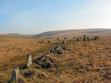
Stall Moor (Upper Erme) Stone Row
Prehistoric Dartmoor Walks: Dartmoor Site: Upper Erme Stone Row & Cairn Circle
OS Map: SX 63663 67796
HER: MDV4309
Megalithic Portal: 1464
The Stone Rows of GB: Upper Erme
PMD: Stall Moor Stone Row
Alternate name: Upper Erme Row Stone Row
ShortName: SR Stall Moor
Butler map: 55.7
DPD page: 71
Notes: Worth: Stall Moor. Butler: Upper Erme. The longest stone row on Dartmoor. "A single stone row running for approximately 3.1km from a cairn on Green Hill to a stone circle on Stall Moor". Lethbridge pp.71-72, diagram p.71
Nearby sites: SX 63663 67796
Distance: 1.67km