
Guide to the Langcombe Brook & Deadman's Bottom Cists
The Langcombe Brook (SX60866640 Butler Vol. 3. Map 50, 1) and it's tributary the Deadman's Bottom is the location of 11 fairly evenly spaced cists. This is the area just south of Plym Steps off the River Plym. The naming of these Dartmoor sites has unfortunately been rather haphazard reflecting the descriptions and subsequent discoveries of various authors. The impressive Grims Grave and Plym Steps cists have been widely known as such for a long time. The Deadman's Bottom North and South cists are a pair very close together that were described and named as such in the 12th and 19th Barrow Reports of the Devonshire Association. The 53rd Barrow report in 1934 added sites named by Worth as Deadman's Bottom D, E & F. Later listings such as by Butler have numbered the cists. This has given us the curiously named Langcombe Brook 5 & 7 cists.
The only possible way to bring clarity to these sites is to provide a map and a table so that it is possible to match up and cross-reference the various contradictory names. The current author can either add to the confusion by introducing a new system or adopt those already in circulation. The most coherent published listing is that provided by Lethbridge Cists A-K (2015 p.43). An alternative and more widely known listing is provided by Butler Cists 1-11 (1994 p.151) which are matched up in the table above. Clicking on the column headers in the table will order the table by that column. Grinsell (1978 p.109) gives a map of the SHAUGH PRIOR cairns covering this area. Petit (1974 p.120) also gives a useful illustration of these sites without numbering or labelling.
The diagram below adopts the listing used by Lethbridge (2015) with the Butler number in brackets. In addition to Lethbridge's Cists A-K (or Butler 1-11) there is also listed a cairn in the Prehistoric Dartmoor Walks database which is marked as L in the diagram (Butler 0 - as not on the Butler diagram). The table above matches these up with the Prehistoric Dartmoor Walks listings, the NMR, HER & Megalithic Portal listings.

Diagram of the Langcombe Brook & Deadmans Bottom Cists
The Langcombe Brook and Deadman's Bottom Cists
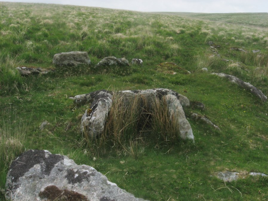
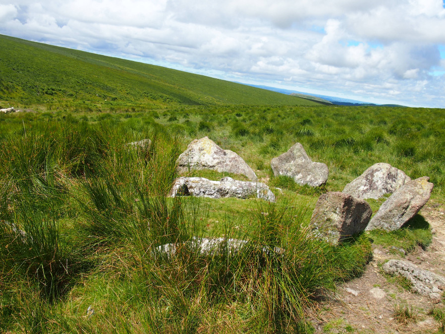
Deadman's Bottom, South Ring Setting Cairn and Cist
Paved Circles and the Deadman's Bottom North & South Cists (Barrow Report 19)
In 1899-1900 the Dartmoor Exploration Committee investigated cists along the moorland valley of the Plym. The relevant section of the report is reproduced below, see Extract from Nineteenth Barrow Report
The excavation of the Plym Steps Ring Setting Cairn and Cist "yielded the remains of a fox which had apparently crept into the cist to die, but nothing of greater antiquity".
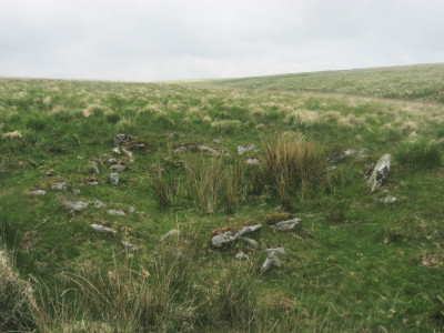
The Deadman's Bottom excavations were far more interesting. These two cists are very close together and are within a curious arrangement of paved circles. Nothing was found in the Deadman's Bottom, North Cist, the report stated "Excavation yielded no result. There was a foot of peat over the subsoil floor, but this contained no trace of pottery or flint, nor indeed any object of interest."
The excavation of the Deadman's Bottom, South Cist "proved a highly profitable undertaking. It contained 1 foot 2 inches of peat over the subsoil floor, and on the removal of this numerous fragments of pottery, all apparently belonging to the same vessel, were found resting on and partly embedded in the floor". Also at "the extreme western limit of the kistvaen, where the side-stone had been removed, three barbed and tanged flint arrow-heads were found, in perfect condition and of fine workmanship."
These two cists are found in conjunction with some curious paved circles. Worth states that these circles do not have entrances and for this reason cannot be hut circles. Two of these circles were excavated revealing a paved floor on which was charcoal. The soil in that area is an umber (yellowish-brown) colour but under "the pavement, however, and in places to a depth of 10 inches, it is now a light brick-red, grading after this depth is reached into the dull natural colour. At some time a considerable fire must evidently have been maintained within this circle. The red colour goes deeper in the centre of the circle than elsewhere, and penetrates to a much less depth at the circumference."
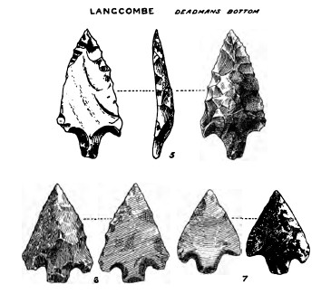
Three arrow heads excavated from Deadman's Bottom, South Cist (Barrow Report 19)
Worth observes that "the pavement in these circles exactly resembles that found under many small barrows of similar diameter. Here, however, there were no traces of barrows having ever been raised within the circles". He goes on to speculate that "the cremations took place within these circles and that the ashes were transferred to urns subsequently placed in the adjacent kistvaens."
Butler (1994 pp.148-152) is sceptical of Worth's interpretation of this site and suggests that the circles are indeed hut circles. According to Butler:
"[Worth] took no account of the boundary bank, normally associated with hut circles, curving away downhill from circle 1 for about 40 metres before becoming lost. The section between the circles seems to have been demolished but a short length again becomes visible above circle 2. If ever completed the rest of the circuit is probably simply buried beneath the turf. However, neither ring was found to have an entrance as would be expected in a dwelling, despite apparently the obvious gap in the wall of circle 1."
Butler suggests the intense fires within the circles were "possibly for ordinary domestic reasons or, as Worth suggested, as funeral pyres".
It is difficult to say which conclusion is correct. Overall the site does have a rather peculiar appearance for a settlement and the fact remains that circle 2 has no entrance and looks more cairn like as a structure. There is also an additional circle 3 between circle 2 and the trace of a bank around the northern cist. This circle is not shown in the Barrow Report 19 but can be seen in a diagram in Butler (1994 p.149). Circles 2 & 3 are unusually close together for hut circles they almost form a figure of eight. Circle 1 can be seen in the photo above. The bank of the circle does not look much like walling although as Butler says there can be seen an entrance into the circle towards the bottom right of the photo, so maybe it is a hut circle. Another possibility is that former hut circles have been used for funerary purposes at a later date. Butler (1997 p.137) suggests that "occasionally a hut circle has simply been dismantled to provide material for a nearby cairn, possibly for the two cisted graves at Deadman's Bottom ...".
Hut circle or cairn circle? Circle 1 at SX 60798 66895.
Google satellite of Deadman Bottom Huts and Circles. Click on + to go in closer
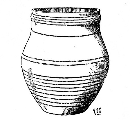
Reconstruction of beaker excavated from Deadman's Bottom, South Cist (Barrow Report 19)
The wider area is also of great intrigue and interest. As Butler points out:
"The siting of the two cists at this location seems to have been partly determined by the distance from neighbouring cairns. Unlike the other cist groups along the Plym at Drizzlecombe and Hen Tor, these appear to have been deliberately spaced along the lower valley sides at definite intervals, between 350 and 380 m apart. Excluding the two paired examples, cairns 3, 4, 5, 9 and 11 conform to this interval, and both 5, 7 and 8, 9 are double the distance (about 700 m), suggesting cist 1 and 2 were sited about 50 m too far to the east, perhaps taking advantage of a ready source of stone. The only other exception is the gap between neighbouring cairns 5 and 6, which may have been reduced as the full interval would have placed the latter well beyond the source of the stream".
Many of these cists are impressive. Grims Grave (see photo at bottom of this page) is one of the most impressive on Dartmoor as is the Plym Steps cist. Several of these cists are relatively intact still including their covers. Cairn 5 is reportedly hard to find and the current author was unable to locate it on the first and so far only attempt in June 2016. According to Butler (1994) the cairn of Cairn 10 has almost entirely disappeared and "and the cist itself will probably be lost within a few years". This may explain why that one could not be located either! For photos and further details of all the rest and also the Calveslake Cist see the locality search within 1 km of SX610667.
See also:
Bibliography & references
Butler, J. Dartmoor Atlas of Antiquities: Vol. 3. - The South-West (Devon Books, 1994)
Butler, Jeremy, Dartmoor Atlas of Antiquities, vol.5: The Second Millennium B.C., (1997)
Grinsell, L.V., Dartmoor Barrows, Devon Archaeological Society Proceedings No. 36 (1978)
Lethbridge, W.D. Discover Prehistoric Dartmoor (Halsgrove, 2015)
Pettit, Paul, Prehistoric Dartmoor, (1974)
Worth, R.H. Worth's Dartmoor (David & Charles, 1971)
Worth, R.H. Nineteenth Report of the Barrow Committtee Report & Transactions of the Devonshire Association Vol. 32 (1900)
Worth, R.N. Twelfth Report of the Barrow Committtee Report & Transactions of the Devonshire Association Vol. 22 (1890)
External Links
Excavation of Deadman's Bottom Cairns & Cists
Extract from nineteenth report of the Barrow Committee
The following report by R.H Worth describes the finds made during the excavations in 1899-1990 at Deadman's Bottom. It is taken from Report & Transactions of the Devonshire Association Vol. 32 (1900) pp.46-54.
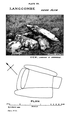
6. Langcombe Near Plym Steps (Plate VII.)
A well preserved example; the sides stand partly above ground, although traces of the covering barrow are distinctly visible. The cover-stone rests on one of the long sides, and partly overhangs the cist.
This kistvaen stands on the hillside, in the angle between the south bank of the Plym and the east bank of the Langcombe Brook.
Length, east side, 2 feet 5 inches; west side, 2 feet 9 inches. Width, south end, 1 foot 1 inch; north end, 1 foot 11 inches; depth to floor, 2 feet. Direction of length, 41 degrees west of north.
Excavation yielded the remains of a fox which had apparently crept into the cist to die, but nothing of greater antiquity.
[N.B This is Butler Cist 8 (Lethbridge B), see: Plym Steps Ring Setting Cairn and Cist]
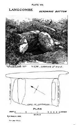
7. Langcombe, near Deadman's Bottom (Plate VIII.)
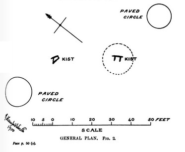
The southern of two adjoining kistvaens, which stand on the brow of the hill to the north of Deadman's Bottom, a valley indicated on the Ordnance Map, but not there named. It is the valley of the first stream that falls into the Langcombe, on the eastern bank, south of its junction with the Plym. Three sides only of this kistvaen now stand, and these are partly above ground. The remains of the barrow are, however, still visible, and the cist is surrounded by a stone circle having a diameter of 16 feet; the eastern side of this circle is still perfect.
Length of kistvaen, 2 feet 4 inches; length at floor-level, 4 feet 2 inches; width, south end, 2 feet 6 inches; width, north end, 2 feet 3½ inches; depth to floor, 2 feet 10 inches; direction of length, 30 degrees west of north; cover-stone 6 feet by 4 feet 9 inches. The excavation of this cist proved a highly profitable undertaking. It contained 1 foot 2 inches of peat over the subsoil floor, and on the removal of this numerous fragments of pottery, all apparently belonging to the same vessel, were found resting on and partly embedded in the floor.
Small portions of the rim, base, and central part of the vessel are sufficiently well preserved to enable measurements to be taken with fair accuracy. Thus, from the curvature of these fragments it is possible to say that the diameter of the urn at its mouth was 11.1 cm., its greatest diameter 15.2 cm., and the diameter of the base slightly under 10 cm. The height of the um can only be guessed at by an attempt to fit together the profiles of the fragments available; it may have been about 18 cm. The material is similar to that of the pottery found in the hut circles, perhaps slightly superior to some. The outside is brought to a smoother and more uniform surface than the inside, even at the rim, where both were readily accessible. The average thickness is from 5 to 6 mm. For restoration, see Plate IX., Fig. 1.
Ornamentation is supplied by a series of horizontal lines (parallel to the plane of the base); four of these encircle the rim, which is also moulded slightly. Bands of the same ornament occur both above and below the point of greatest diameter, and between these a plain strip is left exactly coinciding with the largest circumference of the urn.
Beyond this pottery nothing was found at the south end of the kistvaen. At the north end there had been a pit about 7 inches in diameter and 7 inches deep sunk below the floor. This might, however, represent the work of previous searchers.
At the extreme western limit of the kistvaen, where the side-stone had been removed, three barbed and tanged flint arrow-heads were found, in perfect condition and of fine workmanship. The largest of the three is 37.5 mm. in length, and has a greatest width of 19.5 mm. The next in size is 29 mm. long and 21 mm. across the barbs. The smallest is 24 mm. long and 18.5 mm. across the barbs. Neither of these arrow-heads bears the slightest sign of use, the delicate edges are as perfect as on the day of manufacture. Full sized illustrations are given in Plate I., Figs. 5, 6, and 7.*
*By accident the illustrations have been reproduced slightly larger than the arrow-heads. [See main article above Barrow Report]
[N.B This is Butler Cist 1 (Lethbridge D), see: Deadman's Bottom, South Ring Setting Cairn and Cist]
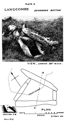
8. Langcombe, near Deadman's Bottom (Plate X.)
The northern kistvaen, almost due north from No. 8, and at a distance of 31 feet 6 inches from centre to centre.
Much deformed. The sides have both leant towards the west, the northern end-stone has slipped in at its eastern end. The cover-stone rests on the eastern side-stone, and its weight has been largely responsible for the damage to the kist.
Original length, inside kistvaen, about 3 feet; width, 10 inches at southern end, 1 foot 10 inches at northern end; depth to floor, 2 feet 6 inches. Direction of west side-stone, 66 degrees west of north.
Excavation yielded no result. There was a foot of peat over the subsoil floor, but this contained no trace of pottery or flint, nor indeed any object of interest. The total absence of result was somewhat disappointing after the find in the adjacent kistvaen.
[N.B This is Butler Cist 2 (Lethbridge C), see: Deadman's Bottom, North Cist]
Nos. 7 and 8 and circles adjacent.*
* [Note from Prehistoric Dartmoor Walks: The text actually erroneously states Nos 8 & 9 in this section. This has been corrected to 7 & 8 throughout.]
The interest did not cease, however, with the examination of the kists. There remained two circles, much resembling small huts, but with a less amount of material in the walls, and no trace of entrances.
These circles were examined, and it then became obvious that circles and kistvaens should be treated together as a group. The unusual association of apparent hut circles and kistvaens was in itself sufficient to arouse suspicion as to the true nature of the former. The relative situation of the circles and kists is shown in Plan on Plate IX., Fig. 2.
Approximately, and without giving exact bearings, the facts are these : The kists stand in a north and south line, 31 feet 6 inches from centre to centre. East from the southern of these two (No. 7) lies a circle whose diameter is 12 feet 6 inches internal, and whose centre is 30 feet 6 inches from the centre of kist 7. Call this circle No. 1. West by north from the northern kist (No. 8) lies a circle of 15 feet inner diameter, the centre of which is 25 feet 6 inches from the centre of kist 8. Call this circle No. 2. About 12 feet outside circle No. 2, and bearing north from its centre, is a single standing stone.
Circle No. 1 was opened
The interior was found to be paved with flat stones, much as some of the smaller barrows are. Nothing but earth was found resting on these stones. A little charcoal lay between them in the joints, but only a little. The pavement, when lifted, proved to have been laid directly on the subsoil of decomposed granite, which, in its usual condition, is the colour of raw umber in this immediate locality. Under the pavement, however, and in places to a depth of 10 inches, it is now a light brick-red, grading after this depth is reached into the dull natural colour. At some time a considerable fire must evidently have been maintained within this circle. The red colour goes deeper in the centre of the circle than elsewhere, and penetrates to a much less depth at the circumference.
Circle No. 2 was opened
The interior was found to be paved with flat stones, as in circle No. 1. There was a little charcoal between these stones.
Here the pavement had been laid on the meat earth, the ground not having been cleared to the subsoil. The protective layer of earth had shielded the subsoil, but slight patches of red baked clay were casually visible.
It should be stated that neither in dimension nor construction do these circles resemble the so-called "sacred circles," which essentially consist of a series of upstanding stones set at some distance from each other. There is, however, a feature in common in the evidence of fire which is found on excavation. As stated above, the pavement in these circles exactly resembles that found under many small barrows of similar diameter. Here, however, there were no traces of barrows having ever been raised within the circles.
It is suggested that the cremations took place within these circles and that the ashes were transferred to urns subsequently placed in the adjacent kistvaens. In the same way it is to be believed that the "sacred circles," such as the "Fernworthy" examples, may have served for successive cremations, in place of one only, as would probably have been the case here; while the small paved barrows afford instances in which the ashes, instead of being transferred to a kistvaen, were covered directly where they lay, in most cues at least, not even being gathered into a pit in the subsoil.
Although these suggestions appear to accord with the circumstances, convincing evidence is, from the mere nature of the case, difficult, if not impossible, of attainment.
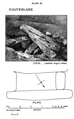
9. Calveslake (Plate XI.)
A very perfect and well constructed kistvaen, the excellent construction being largely consequent on the immediate presence of granite peculiarly well suited to the purpose. Indeed, the adaptability of the available material constantly governs the quality both of kistvaens and stone rows, as well as hut circles and other remains. It is rare to find stones brought from any distance for use in these structures, the great menhir at Drizzlecombe being a possible exception, as in this case the stone would seem to have been fetched from Higher Hartor, two-thirds of a mile away; while on the other hand certain hut circles on Shavercombe Tor emphasise the general rule, and are constructed in altered slate, although granite, much better suited for the work, outcrops close by.
The inside measurements at the top of this kistvaen are: length, 3 feet 7 inches; width at north end, 1 foot 7 inches; at south end, 1 foot 9 inches; depth to floor, 2 feet 7 inches. Direction of length, 57 degrees west of north.
The depth of soil which had accumulated over the floor of the kist was 1 foot.
The cover-stone overhangs the eastern side of the kist. Its shape is irregular, the longer diagonal 7 feet, the shorter 6 feet.
The barrow in which this kist stands has a diameter of 18 feet. There is no circle of stones.
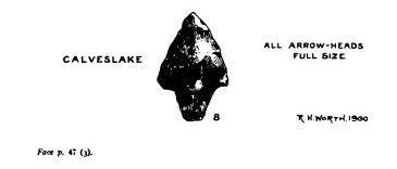
Excavation yielded a single flint arrow-head, 27 mm. in length, greatest breadth 17 mm; tanged but not barbed (Plate I., Fig. 8). The certainty and precision of the two strokes which gave shape to the tang indicate that the maker had a perfect mastery over his material.
No pottery was found, but three rough flint flakes in addition to the arrow-head, and a quartz crystal. This latter may have had some significance.
As regards the three flint flakes, it must be remarked that the whole ground between the kistvaen and Calveslake Tor is liberally strewn with flint chippings. Ten minutes' search yielded fifty chips, some being fragments of cores, others flakes which one would think need not have been thrown away as useless. The edges of some flakes seem to bear evidence of use. There are no hut circles in the neighbourhood, although there has evidently been an implement manufactory here.
Near kist No. 5 in Drizzlecombe similar chippings are not uncommon, but not so numerous.
[N.B This is the: Calveslake Cist]
R. H. WORTH
Grim's Grave Ring Setting Cairn and Cist
Page last updated 10/12/16