
Stall Moor (Upper Erme) Stone Row
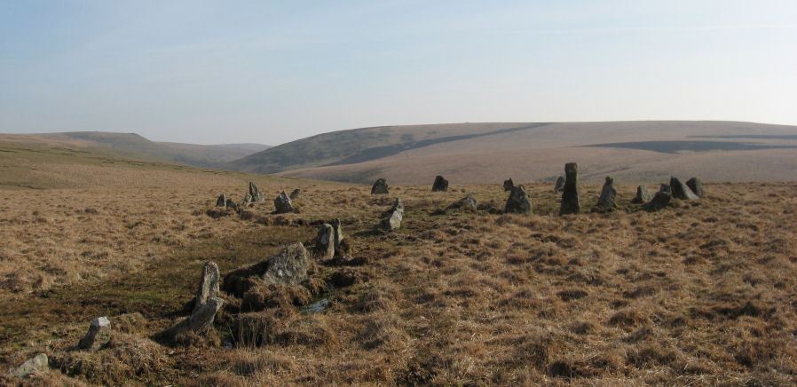
Photo taken on 19-03-2011
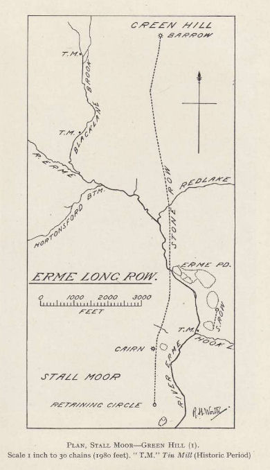
Worth, R. Hansford, The Stone Rows of Dartmoor Part 1, T.D.A. Vol.78
Database entries
PDW coverage: Dartmoor Site: Upper Erme Stone Row & Cairn Circle
OS Map: SX 63663 67796
OS Source: SRGB
HER: MDV4309
Megalithic Portal: 1464
The Stone Rows of GB: Upper Erme
PMD: Stall Moor Stone Row
Alternate name: Upper Erme Row
Short Name: SR Stall Moor
Butler map: 55.7
DPD page: 71
Exist: Yes
Record: Unique
Record Source: PDW
Hut Class: No
Dimensions (m): 3386
Lidar: SX 63663 67796
Guide Map: 51
Nearest Bus Stop: Princetown Dartmoor Visitor Centre (9.6 km) [Route: 98,171(20/07/26 to 19/09/26)]
Nearby sites: SX 63663 67796
Notes
Worth: Stall Moor. Butler: Upper Erme. The longest stone row on Dartmoor. "A single stone row running for approximately 3.1km from a cairn on Green Hill to a stone circle on Stall Moor". Lethbridge pp.71-72, diagram p.71References
These are selected references with an emphasis on out of copyright sources linked as PDFs. For more detailed references try any linked HER or PMD record above.
- Brailsford, J. W, Bronze Age Stone Monuments of Dartmoor, Antiquity Volume 12, Number 48 pp.444-63 (1938)
- Burnard, Robert, Dartmoor Pictorial Records, (1986)
- Butler, Jeremy, Dartmoor Atlas of Antiquities, vol.4: The South-East, (1993)
- Falcon, T.A., Dartmoor: A Note On Graves, T.D.A. Vol.37 pp.457-461 (1905)
- Lethbridge, William D., Discover Preshistoric Dartmoor, (2015)
- Lukis, W.C, Report on the Monuments of Dartmoor, Proceeding of the Society of Antiquaries Vol.8 (1881)
- Newman, Phil, The Upper Erme Valley Dartmoor National Park Devon An Archaeological Survey, Southwest Landscape Investigations (2018)
- Page, John Lloyd Warden, An Exploration of Dartmoor and its Antiquities, with some account of its borders, (1889)
- Rowe, Samuel, A Perambulation of Dartmoor (3rd Edition), (1896)
- Worth, R. Hansford, The Erme, Yealm and Torry part 1, T.P.I. Vol.11 part 1 pp.173-183 (1892)
- Worth, R. Hansford, The Stone Rows of Dartmoor - Part 7, T.D.A. Vol.38 pp.535-37 (1906)
- Worth, R. Hansford, Replies to Falcon on Various Issues, Devon and Cornwall Notes and Queries Vol 4 pp.10-13 (1907)
- Worth, R. Hansford, Retaining circles associated with stone rows Dartmoor, T.D.A. Vol.73 pp.227-38 (1941)
- Worth, R.N., The Stone Rows of Dartmoor - Part 1, T.D.A. Vol.24 pp.387-417 (1892)