
Lower Piles Ring Setting Cairn and Cist
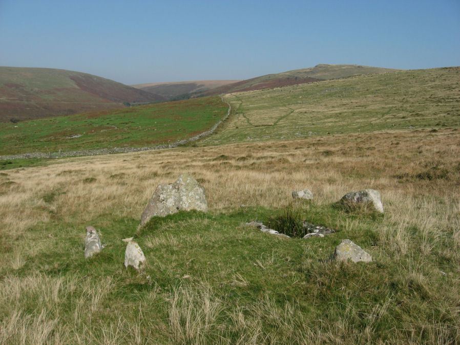
Photo taken on 03-10-2011
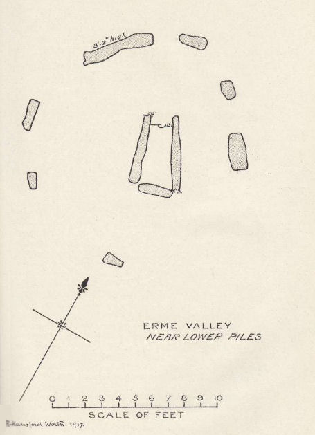
Plan by RHW. Barrow Report 36. TDA Vol.49 1917
Database entries
PDW coverage: Dartmoor Walk: The Neolithic tombs of Cuckoo Ball & Corringdon Ball
OS Map: SX 64540 60262
OS Source: Google
Butler OS: SX64536026
HER: MDV4256
Megalithic Portal: 1108
PMD: Lower Piles
Alternate name: Piles Hill S.W.15
Short Name: CT Lower Piles
Butler map: 53.11.15
Dixon Cist #: 38
Grinsell: HARFORD 8
Turner: D13
DPD page: 76
Exist: Yes
Record: Unique
Record Source: Butler
Hut Class: No
Cist Class: Yes
Cairn Class: Yes
Barrow Report: 36 62
Dimensions (m): 5.4 x 0.3 C
Lidar: SX 64540 60262
Guide Map: 57
Nearest Bus Stop: Cornwood Crossways (5.3 km) [Route: 59]
Nearby sites: SX 64540 60262
Notes
"A cist with a retaining circle, diameter 14 to 15 feet, of which seven stones still remain, lies about 150 yds south of the south east angle of Lower Piles enclosure. The cist measures 3 feet 7 inches in length by 1 foot 4 inches wide at the south-eastern end and 2 feet wide at the north western. The present depth is from 2 feet 9 inches to 3 feet. The cover-stone and the north-western end-stone are missing." Letchfield diagram p.76. Barrow Report 36 says "To the south-east, in the direction of the length of the kistvaen, stands a single large stone, about 100 feet distant; to the north-west, with its centre 110 feet away from the centre of the kistvaen, there is a small cairn of 20 feet diameter; this also is in the line of the length of the kistvaen." The stone is at SX 64518 60236 Butler Piles Hill S.W. - Vol. 4. Map 53.11.15 (p.33 diagram of cist & plan of cairns on Piles Hill p.30).References
These are selected references with an emphasis on out of copyright sources linked as PDFs. For more detailed references try any linked HER or PMD record above.
- Butler, Jeremy, Dartmoor Atlas of Antiquities, vol.4: The South-East, (1993)
- Davidson, C. & Seabrook, R., Stone rings on south-east Dartmoor, D.A.S.P. No.31 (1973)
- Grinsell, L.V., Dartmoor Barrows, Devon Archaeological Society Proceedings No.36 (1978)
- Kelly, John, Celtic Remains on Dartmoor, T.D.A. Vol.1 Pt.5 pp.45-48 (1866)
- Lethbridge, William D., Discover Preshistoric Dartmoor, (2015)
- Rowe, Samuel, A Perambulation of Dartmoor (3rd Edition), (1896)
- Turner, J.R., Ring Cairns, stone circles and related monuments on Dartmoor, D.A.S.P. No.48 pp.27-86 (1990)
- Worth, R. Hansford, The Erme, Yealm and Torry part 1, T.P.I. Vol.11 part 1 pp.173-183 (1892)
- Worth, R. Hansford, Barrow Report 36, T.D.A. Vol.49 pp.79-80 (1917)
- Worth, R. Hansford, Barrow Report 62, T.D.A. Vol.75 pp.53-55 (1943)
- Worth, R.N., The Stone Rows of Dartmoor - Part 1, T.D.A. Vol.24 pp.387-417 (1892)