
Guide to the Monuments on Hingston Hill

Table of Ritual and Burial Monuments on Hingston Hill
The following table lists the records currently in this Guide Map. For an explantion of the Guide Maps and a table of all 62 Guide Maps, follow this link: Guide List Table. Introductory text will be added to each guide list in 2025. Notes on duplication and omissions will appear below the table once checks have been finalised.
Hingston Hill Guide Map
Guidance for walkers: The monuments featured in this database are archaeological treasures and need to be protected and preserved - please do not disturb any sites. Please check access and firing times before visiting sites, not all sites listed are on open access land. Firing ranges and boundaries of open access areas are marked on the OL28 OS Dartmoor Explorer map. Please stick to the country code and consider giving support to the numerous agencies that help to keep Dartmoor a fabulous natural and historic environment!
List of Ritual and Burial Monuments on Hingston Hill
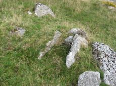
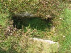
Down Tor Cist
OS Map: SX 58037 69293
HER record: MDV3423
Megalithic Portal: 45757
PMD: Down Tor S.
Alternate name: Down Tor S. Cist
ShortName: CT Down Tor
Butler map: 47.5
DPD page: 28
Grinsell: WAL 26
Barrow Report: 67
Notes: Butler Down Tor S. Vol. 3. Map 47.5 (diagram p.67).
Nearby sites: SX58046929
Down Tor, SE of, Tor cairn Cairn
OS Map: SX 58105 69391
HER record: MDV61957
ShortName: CN:DownTor 1
Notes: "6m by 5.8m by 0.4m high. Two parallel lines of edge set stones form the n side of the cairn. They lead from a large granite outcrop situated to the w. The inner line of stones survives as a 4.3m long by 0.8m wide line of at least 10 stones. The outer is 4m long and also includes at least 10 stones. The s side is denoted by 9 stones set on top of a large granite boulder. The e side includes a jumble of large stones, with others lying on the slope directly below. The w side is formed by the tor. The area enclosed by these features measures 6m wide at the w end, 2.8m wide at the e end and up to 4.3m long e-w."
Nearby sites: SX58116939
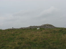
Hingston Hill Enclosed Settlement
OS Map: SX 59118 69477
HER record: MDV3435
Megalithic Portal: 27901
ShortName: ES Down Tor
Butler map: 47.7
DPD page: 29
Notes: "Hingston hill pound, east of down tor, is a circular enclosure whose wall consists of large stones. Entrance is marked by a slab like stone which extends through the thickness of a wall. About 100m from the pound in a direction 15 s of e lies the centre of a cairn, c.18m in diameter at the base. The down tor stone row points to this cairn (Worth)". Lethbridge pp.27-29, diagram p.27. Listed as Narrator Brookhead Enclosure on Megalithic Portal.
Nearby sites: SX59126948

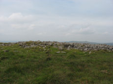
Hingston Hill Chambered Cairn
OS Map: SX 59201 69453
HER record: MDV3375
Megalithic Portal: 27900
PMD: Narrator Brookhead N.
Alternate name: Narrator Brookhead 1 Chambered Cairn
ShortName: CN Narrator 1
Butler map: 47.7.1
Butler Vol 5: p.158
Grinsell: WAL 32
Notes: The large cairn to NW of Down Tor (Hingston Hill) stone row has been claimed to contain a cist or "elements of chambering" (Burnard via PMD). A stony round cairn located on the flatish sadle of Hingston Hill. The cairn mound measures 17 metres in diameter and stands up to 1.5 metres high. A hollow in the centre of the mound measures 4 metres long, 3 metres wide and 1.2 metres deep, and is probably the result of partial robbing or early excavation. The edges of the mound are steep-sided, indicating the existence of a kerb, which now survives mainly as a buried feature. A quarry ditch surrounds the mound, visible as a 1.5 metre wide band of rushes on the northern side of the mound, the result of increased moisture in the buried ditch. This cairn is in direct line with the two terminal stones at either end of a stone alignment to the south-west.
Nearby sites: SX59206945

Narrator Brookhead 2 Reported Cairn
OS Map: SX 59188 69452
HER record: MDV3375
ShortName: CN Narrator 2
Butler map: 47.7.2
Notes: Butler: AT the base of Narrator Brookhead 1 on the west side are two tiny mounds nomore than 2.5m across containing upended slabs, miniature cairns like those at the foot of Giant's Basin.
NB. Butler gives a grid reference for these two satellite cairns at SX 5864 6931 which is the cairn circle attached to the stone row at the western end and not Narrator Brookhead 1. A rare mistake by Butler. Thanks to Steve Szypko for assistance in locating this cairn. NB. The HER entry for MDV3375 includes a reference to the Cairn 2 and Cairn 3 (no seprate record)
Nearby sites: SX59196945

Narrator Brookhead 3 Reported Cairn
OS Map: SX 59190 69448
HER record: MDV3375
ShortName: CN Narrator 3
Butler map: 47.7.3
Notes: Butler: AT the base of Narrator Brookhead 1 "on the west side are two tiny mounds nomore than 2.5m across containing upended slabs, miniature cairns like those at the foot of Giant's Basin". No entry in NMR or HER.
NB. Butler gives a grid reference for these two satellite cairns at SX 5864 6931 which is the cairn circle attached to the stone row at the western end and not Narrator Brookhead 1. A rare mistake by Butler. Thanks to Steve Szypko for assistance in locating this cairn. NB. The HER entry for MDV3375 includes a reference to the Cairn 2 and Cairn 3 (no seprate record)
Nearby sites: SX59196945

Narrator Brookhead 4 Reported Cairn
OS Map: SX 59097 69371
HER record: MDV131006
ShortName: CN?Narrator 4
Butler map: 47.7.4
Notes: Buler lists this as a small cairn. HER: A small cairn located on the flatish area 130 metres south-west of the large Hingston Hill cairn. The cairn comprises a turf-covered stony mound of 5 metres diameter by 0.5 metres high. Disturbance in the centre of the cairn consists of a 1.5 metres by 1.2 metres by 0.2 metres deep pit.
Nearby sites: SX59106937

Narrator Brookhead 5 Reported Cairn
OS Map: SX 59265 69451
HER record: MDV132194
ShortName: CN Narrator 5
Butler map: 47.7.5
Notes: Butler: the overgrown remains of another [cairn] with two inner rings but no apparent retaining circle.
The feature in the photo and at the grid reference for this record is at SX 5927 6945. The grid reference given by Butler is SX 5926 6944. The feature looks like a cairn but doesn't match the description given by Butler very well. Is this a correct identification?
Nearby sites: SX59276945
Hemery's Rows Reported Cist
OS Map: SX 59100 69300
HER record: MDV56216
PMD: Hemery's Rows
Alternate name: Hemery's Rows Reported Cist
ShortName: CT?Hemery
Notes: "Aligned with the row and two hundred yards beyond its termination is a cairn, and near this a pear-shaped pound having one good entrance-jamb standing; a little to the south there stands a much overgrown single row (of only nine stones) leading to the (probable) remains of a kistvaen, and yet another single row, fallen and overgrown leading north-east to a ruined cairn". Hemery High Dartmoor p.147
Nearby sites: SX59106930
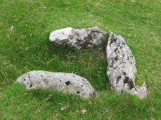
Outholme Newtake Cist
OS Map: SX 57993 68278
HER record: MDV4024
Megalithic Portal: 45730
PMD: Outcombe
ShortName: CT OutholmeNew
Butler map: 47.10
DPD page: 30
Grinsell: SHE 2
Barrow Report: 52
Notes: "Located in an isolated pocket of closely cropped grass and surounded by tinners pits. Only three slabs survive in place surrounding a hollow and forming the sides of the cist. The fourth side is missing as is the capstone and any trace of a mound." Lethbridge Outcombe (note different spelling) Cist p.30. Butler Vol. 3. Map 47.10 (diagram p.70).
Nearby sites: SX57996828
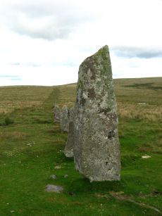
Hingston Hill (Down Tor) Standing Stone
OS Map: SX 58702 69276
HER record: MDV3502
Megalithic Portal: 1901
PMD: Down Tor Standing Stone
ShortName: SS Down Tor
Butler map: 47.12
DPD page: 29
Notes: "A stone alignment and cairn, situated on a saddle 620 metres east of Down Tor. The alignment is orientated east-north-east to west-south-west, running for 316 metres and containing at least 174 stones, with the tallest at either end. The westernmost stone stands 2.8 metre high, the easternmost stone stands 1.6 metres high, and the remainder vary between 1 metre and 0.2 metres in height. The westernmost stone, and an unknown number of others, were re-erected by Baring-Gould and Burnard in 1890."
Nearby sites: SX58706928
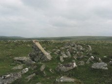
Hingston Hill (Down Tor) Stone Row
OS Map: SX 58697 69267
HER record: MDV3502
Megalithic Portal: 1901
The Stone Rows of GB: Hingston Hill
PMD: Down Tor Stone Row
Alternate name: Hingston Hill Stone Row
ShortName: SR Down Tor
Butler map: 47.12
DPD page: 28
Barrow Report: 66
Notes: "A stone alignment and cairn, situated on a saddle 620 metres east of Down Tor. The alignment is orientated east-north-east to west-south-west, running for 316 metres and containing at least 174 stones, with the tallest at either end."
Nearby sites: SX58706927
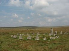
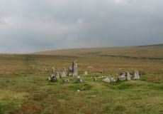
Hingston Hill (Down Tor) Encircled Cairn
OS Map: SX 58693 69270
HER record: MDV3439
Megalithic Portal: 541
PMD: Down Tor Cairn Circle
Alternate name: Hingston Hill stone row Encircled Cairn
ShortName: EC Down Tor
Butler map: 47.12
DPD page: 28
Grinsell: WAL 31
Turner: F6
Barrow Report: 14
Notes: "The cairn circle consists of 26 upright stones and possibly two more now recumbent; it has an internal diameter of 11.5m. Within the circle is a cairn of 8.5m diameter and 0.6m height with a small depression in the centre which may be the site of a cist". Lethbridge pp.27-29, diagram p.27.
Nearby sites: SX58696927
Down Tor Cairn
OS Map: SX 58642 69315
HER record: MDV3440
Megalithic Portal: 27903
Alternate name: Hingston Hill Summit 1 Cairn
ShortName: CN Hingston 1
Butler map: 47.12.1
Grinsell: WAL 30
Notes: "cairn mound measures 15.5m in diam and stands up to 1.5m high. A t-shaped trench cutting into the centre of the mound suggests partial early excavation, though the results of the investigation are not known. This cairn forms part of a ritual complex of monuments including 3 cairns, a stone alignment and enclosure". Approx 70 m NW of the cairn circle at the end of the Down Tor stone row.
Nearby sites: SX58646932
Hingston Hill Summit 2 Reported Cairn
OS Map: SX 58753 69483
HER record: MDV130432
ShortName: CN-Hingston 2
Butler map: 47.12.2
Notes: Butler: "Another burial mound lies just over the crest 220 m to the north [of te Down Tor cairn and row], an inconspicuous mound at the centre close to a line of tinners' pits". No entry in NMR or HER.
Nearby sites: SX58756948
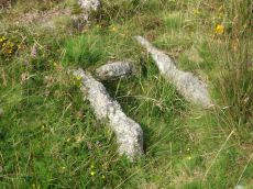
Down Tor N.E. (Northern) Cist
OS Map: SX 58388 69568
HER record: MDV3498
Megalithic Portal: 52348
PMD: Down Tor N 1
Alternate name: Hingston Hill N.1 Cist
ShortName: CT DownTorNE N
Butler map: 47.13.1
DPD page: 27
Grinsell: WAL 28
Barrow Report: 73
Notes: Butler Hingston Hill N. 1. - Vol. 3. Map 47.13.1 (diagram p.73 OS SX58386956). Grinsell (OS SX58256951 approx same as HER record MDV3498). Lethbridge p.27 Cist No.3.
Copyright for photos and plans from Barrow Reports 71-73 belongs to the Dixon estate. Reproduced here with kind permission.
Nearby sites: SX58396957
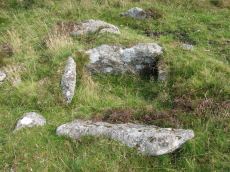
Down Tor N.E. (Western) Cist
OS Map: SX 58386 69565
HER record: MDV3497
Megalithic Portal: 45766
PMD: Down Tor N 2
Alternate name: Hingston Hill N.2 Cist
ShortName: CT DownTorNE W
Butler map: 47.13.2
DPD page: 27
Grinsell: WAL 27
Barrow Report: 73
Notes: Butler Hingston Hill N.2. - Vol. 3. Map 47.13.2 (diagram p.73, OS SX58376955). Grinsell (OS SX58246950 approx - same as the HER record MDV12715). Lethbridge p.27 Cist No.2.
Copyright for photos and plans from Barrow Reports 71-73 belong to the Dixon estate. Reproduced here with kind permission.
Nearby sites: SX58396957
Down Tor N.E. (Eastern) Platform Cairn Circle and Cist
OS Map: SX 58397 69562
HER record: MDV3499
Megalithic Portal: 52347
PMD: Down Tor N 3
Alternate name: Hingston Hill N.3 Platform Cairn Circle and Cist
ShortName: CT DownTorNE E
Butler map: 47.13.3
DPD page: 27
Grinsell: WAL 29
Turner: E34
Barrow Report: 73
Notes: Butler Hingston Hill N. 3. - Vol. 3. Map 47.13.3 (diagram p.73 OS SX58396955). Grinsell WALKHAMPTON 29 (OS 58276949 approx - same as HER MDV3499). Lethbridge p.27 Cist No.1.
Copyright for photos and plans from Barrow Reports 71-73 belongs to the Dixon estate. Reproduced here with kind permission.
Nearby sites: SX58406956

Hingston Hill Cup Stone
OS Map: SX 58596 69210
HER record: MDV133690
ShortName: CS Down Tor
Notes: "A flattish boulder recorded at SX 58595 69204, a short distance west of the north-south reave which lies west of the Down Tor stone row. The upper surface of this boulder is pitted over an area of at least 1m by 1m with numerous possible cupmarks. It is unlike any other boulder in the near vicinity."
Nearby sites: SX58606921
Deancombe Valley Cup Stone
OS Map: SX 57638 69264
HER record: MDV133691
ShortName: CS Deancombe
Notes: "SX 57638 69264 Two discreet circular cupmarks of ‘classic’ type are visible on the top surface of a small granite rock which is situated close to the base of the vertical west face of a massive boulder (one of the largest in the Deancombe valley)."
Nearby sites: SX57646926
Deancombe Cairn
OS Map: SX 57700 68810
HER record: MDV20592
ShortName: CN:Deancombe
Notes: HER: Prehistoric cairn? Probable prehistoric barrow lying in an area of tin workings just south of a track between Middleworth and Deancombe. It consists of a smooth low mound c.12m diameter with a small depression in the centre of it. Probing by J. Turner indicates that it may be of earth / turf construction.
Nearby sites: SX57706881
Cuckoo Rock Cup Stone
OS Map: SX 58463 68712
HER record: MDV133689
Megalithic Portal: 58581
ShortName: CS Cuckoo Rock
Notes: "There appear to be eight circular cupmarks on the south-west corner of Cuckoo Rock in the Deancombe valley; apparently in pairs. Three pairs are arranged horizontally with a smaller pair just above them arranged vertically. Six of the marks measure approximately 5cm diameter by 2cm deep. The remaining two marks measure approximately 2cm diameter by 1cm deep. The carver likely stood on a boulder situated below to mark the rock. Reported to archaeologist at Dartmoor National Park authority who has visited the site (21/11/2022) and agrees with potential interpretation."
Nearby sites: SX58466871
Cuckoo Rock (c.8) Cairnfield Master
OS Map: SX 59090 68810
HER record: MDV3477
ShortName: CN:Cuckoo M
Notes: This is the master record for a cairn cemetery and as such set as a duplicate record. See individual entries.
Nearby sites: SX59096881
Cuckoo Rock 1 Cairn
OS Map: SX 59090 68810
HER record: MDV3477
ShortName: CN:Cuckoo 1
Notes: UPDATE 31/12/2022. The 8 HER records MDV66371 - MDV66378 that these records were based on have since been deleted. The old NMR record has this entry:
Summary: Remains of a cairnfield and enclosure. The cairnfield contains at least sixteen circular and oval mounds, with five arranged in a single line along the contour. The enclosure, which incorporates two of the cairns, is defined by a rubble bank.
Nearby sites: SX59096881
Cuckoo Rock 2 Cairn
OS Map: SX 59120 68810
HER record: MDV3477
ShortName: CN:Cuckoo 2
Notes: UPDATE 31/12/2022. The 8 HER records MDV66371 - MDV66378 that these records were based on have since been deleted. Summary : Remains of a cairnfield and enclosure. The cairnfield contains at least sixteen circular and oval mounds, with five arranged in a single line along the contour. The enclosure, which incorporates two of the cairns, is defined by a rubble bank. NB. See first of these records for further details.
Nearby sites: SX59126881
Cuckoo Rock 3 Cairn
OS Map: SX 59080 68780
HER record: MDV3477
ShortName: CN:Cuckoo 3
Notes: UPDATE 31/12/2022. The 8 HER records MDV66371 - MDV66378 that these records were based on have since been deleted. Summary : Remains of a cairnfield and enclosure. The cairnfield contains at least sixteen circular and oval mounds, with five arranged in a single line along the contour. The enclosure, which incorporates two of the cairns, is defined by a rubble bank. NB. See first of these records for further details.
Nearby sites: SX59086878
Cuckoo Rock 4 Cairn
OS Map: SX 59090 68750
HER record: MDV3477
ShortName: CN:Cuckoo 4
Notes: UPDATE 31/12/2022. The 8 HER records MDV66371 - MDV66378 that these records were based on have since been deleted. Summary : Remains of a cairnfield and enclosure. The cairnfield contains at least sixteen circular and oval mounds, with five arranged in a single line along the contour. The enclosure, which incorporates two of the cairns, is defined by a rubble bank. NB. See first of these records for further details.
Nearby sites: SX59096875
Cuckoo Rock 5 Cairn
OS Map: SX 59100 68740
HER record: MDV3477
ShortName: CN:Cuckoo 5
Notes: UPDATE 31/12/2022. The 8 HER records MDV66371 - MDV66378 that these records were based on have since been deleted. Summary : Remains of a cairnfield and enclosure. The cairnfield contains at least sixteen circular and oval mounds, with five arranged in a single line along the contour. The enclosure, which incorporates two of the cairns, is defined by a rubble bank. NB. See first of these records for further details.
Nearby sites: SX59106874
Cuckoo Rock 6 Cairn
OS Map: SX 59100 68730
HER record: MDV3477
ShortName: CN:Cuckoo 6
Notes: UPDATE 31/12/2022. The 8 HER records MDV66371 - MDV66378 that these records were based on have since been deleted. Summary : Remains of a cairnfield and enclosure. The cairnfield contains at least sixteen circular and oval mounds, with five arranged in a single line along the contour. The enclosure, which incorporates two of the cairns, is defined by a rubble bank. NB. See first of these records for further details.
Nearby sites: SX59106873
Cuckoo Rock 7 Cairn
OS Map: SX 59120 68780
HER record: MDV3477
ShortName: CN:Cuckoo 7
Notes: UPDATE 31/12/2022. The 8 HER records MDV66371 - MDV66378 that these records were based on have since been deleted. Summary : Remains of a cairnfield and enclosure. The cairnfield contains at least sixteen circular and oval mounds, with five arranged in a single line along the contour. The enclosure, which incorporates two of the cairns, is defined by a rubble bank. NB. See first of these records for further details.
Nearby sites: SX59126878
Cuckoo Rock 8 Cairn
OS Map: SX 59150 68790
HER record: MDV3477
ShortName: CN:Cuckoo 8
Notes: UPDATE 31/12/2022. The 8 HER records MDV66371 - MDV66378 that these records were based on have since been deleted. Summary : Remains of a cairnfield and enclosure. The cairnfield contains at least sixteen circular and oval mounds, with five arranged in a single line along the contour. The enclosure, which incorporates two of the cairns, is defined by a rubble bank. NB. See first of these records for further details.
Nearby sites: SX59156879
Newleycombe Lake Cairn
OS Map: SX 59630 69830
HER record: MDV52393
ShortName: CN:Newleycombe
Nearby sites: SX59636983
Eylesbarrow Cairn
OS Map: SX 59971 68587
HER record: MDV4014
ShortName: CN Eylesbarrow
Butler map: 47.15
Grinsell: SHE 3
Barrow Report: 12
Notes: Southern of the 2 large cairns. Butler had SHE 2 - typo!
Nearby sites: SX59976859
Eylesbarrow 1 Cairn
OS Map: SX 59958 68627
HER record: MDV4031
ShortName: CN Eylesbarr 1
Butler map: 47.15.1
Grinsell: WAL 33
Barrow Report: 12
Notes: Northern of the 2 large cairns
Nearby sites: SX59966863

Eylesbarrow 2 Cairn
OS Map: SX 60001 68627
HER record: MDV132199
ShortName: CN Eylesbarr 2
Butler map: 47.15.2
Notes: Butler: "Not unusually smaller cairns share the peaks withhe giants and two can be found east of th larger cairn (HER 4014) approximately in line with the reave. Recently added to HER. Thanks to Steve Szypko for assistance locating this feature on 31/10/24.
Nearby sites: SX60006863

Eylesbarrow 3 Cairn
OS Map: SX 60061 68646
HER record: MDV132200
ShortName: CN?Eylesbarr 3
Butler map: 47.15.3
Notes: Butler: "Not unusually smaller cairns share the peaks withhe giants and two can be found east of th larger cairn (HER 4014) approcimately in line with the reave. Recently added to HER. Thanks to Steve Szypko for assistance locating this feature on 31/10/24.
Nearby sites: SX60066865
Eylesbarrow 4 Reported Cist
OS Map: SX 59400 68200
HER record: MDV131234
PMD: Narrator Brookhead S
ShortName: CT?Eylesbarr 4
Notes: Doubtful. SX 59406820. The site of a possible cist lies on the lower SW flank of Eylesbarrow some 400m W of Eylesbarrow Mine.The feature is marked by a single upright slab 1.1m long 0.2m wide and 0.3m high resembling a sidestone adjacent to a second slab 1.4m long and 0.9m wide perhaps representing the coverstone.Both stones are earthfast and are surrounded by a cluster of smaller stones which could represent the remains of a cairn. The area surrounding these stones has been disturbed by later tin extraction activity and it is also possible that they are products of this activity.
Nearby sites: SX59406820
Page last updated 10/12/24