
Prehistoric Settlements
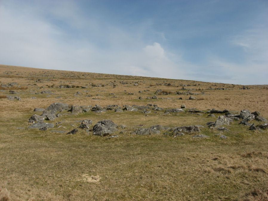
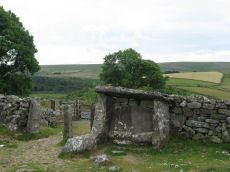
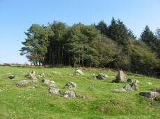
Photo: Walkhampton Enclosed Settlement
There are numerous prehistoric settlements on Dartmoor too many to give complete listings. Some of the larger enclosed settlements were added to the database along with some settlements that specifically feature on some of the walks on this website. The main source for the list of enclosed settlements are those that feature in Petit's Prehistoric Dartmoor. This listing has been added to make the database entries for settlements easy to see in one place.
Bibliography & references
Butler, J. Dartmoor Atlas of Antiquities: Vol. 5. - The Second Millennium B.C. (Devon Books, 1997)
Newman, Phil The Field Archaeology of Dartmoor (English Heritage, 2011)
Pettit, Paul. Prehistoric Dartmoor (David & Charles, 1974)
Worth, R.H. Worth's Dartmoor (David & Charles, 1971)
Listing of some of the Prehistoric Settlements on Dartmoor
About the Database Listings
Details of archaeological sites used to be kept in the Sites and Monuments Records (SMRs). These are now held in National Monument Records (NMRs) maintained by English Heritage although these in turn are being merged into Historic Environment Records (HERs). The NMRs contains details of the site and will often include field notes, a limited bibliography and other useful information. Another rich source of such information is Bill Radcliffe's Prehistoric Monuments of Dartmoor (PMD) website. The records below were compiled independently from books and journals and then matched to the NMR records and then cross-referenced with any corresponding PMD records to ensure accuracy. Each record has a link to corresponding NMR and PMD records, a link to the location on the Ordnance Survey map, a photo (if available) and a link to relevant coverage on Prehistoric Dartmoor Walks and a link giving a listing of nearby sites. The HER records are not included as they do not yet have much information but they can be looked up via the PMD records. The author would like to thank Bill Radcliffe for the helpful correspondence whilst checking records. See also: Database and Web Search Tools
- NMR = Pastscape National Monument Record
- HER = Historic Environment Record
- PMD = Prehistoric Monuments of Dartmoor Record
- DPD = Discover Prehistoric Dartmoor page number
- Short Name is named used in GPS listings
Default listing is by Site Name, click here to order instead by: Site Name, OS
Archerton Settlement
OS Map: SX 641 788
HER: MDV5931
Megalithic Portal: 42727
Short Name: ST:Archerton
Notes: An oval pound now planted with trees. Rowe noted remains of banks and a hut within the enclosure. Prowse mentions traceable sub-division banks with distinct evidence of nine hut circles and a further one, ten yards diameter, "close outside on the east". See: T.D.A. Vol. 23 pp.311-12
Nearest Bus Stop: Postbridge Post Office (0.6 km) [Route: 98,171(20/07/26 to 19/09/26)]
Nearby sites: SX 641 788
Bellever Settlement
OS Map: SX 646 767
HER: MDV5919
Megalithic Portal: 23723
Short Name: ST:Bellever
Notes: Hut circle at Bellever excavated in recent years. See also A dig in Devon reveals how life was lived 3,500 years ago: from cookery to DIY and Bellever's bustling Bronze Age uncovered
Nearest Bus Stop: Postbridge Bellever (1.1 km) [Route: 98]
Nearby sites: SX 646 767
Bellever Tor N. Enclosed Settlement
OS Map: SX 64485 76808
HER: MDV27672
Megalithic Portal: 24263
Short Name: ES BelleverTor
Notes: The photo was taken at SX 64510 76849.
Nearest Bus Stop: Postbridge Bellever (1.2 km) [Route: 98]
Nearby sites: SX 64485 76808
Berry Pound
OS Map: SX 71325 80349
HER: MDV8754
Short Name: PD:Berry
Butler map: 20.3
Notes: Butler (1991): Prehistoric pound clinging to the steep hillside beside the East Webburn river. Its was included within later enclosures on the east side of the down. All traces of huts, which were almost certainly present, have been cleared from within and the marks of the plough can be clearly seen scoring the interior. The site was exceptionally steep for a pound and stones from the inner wall uphill have slid down the slope in a confused tumble with only the largest remaining in place. The Medieval ridge and furrow in the outer field run right up to the walls of a small longhouse to the east. Other details: Map 20, Site 3, Figure 20.3.
Nearest Bus Stop (Minor): Swallerton Gate (2.9 km) [Route: 271]
Nearest Bus Stop (Major): Postbridge Bellever (6.5 km) [Route: 98]
Nearby sites: SX 71325 80349
Blatchford Brook Foot Enclosed Settlement
OS Map: SX 63551 63821
HER: MDV27894
Megalithic Portal: 14935
Short Name: ES:Blatchford
Nearest Bus Stop: Cornwood Crossways (5.2 km) [Route: 59]
Nearby sites: SX 63551 63821
Broadun Enclosed Settlement
OS Map: SX 6354 7993
HER: MDV5946
Megalithic Portal: 26043
Short Name: ES:Broadun
Notes: "An enclosed settlement, maximum dimensions 300m NE/SW by 250m NW/SE, giving an area of 6ha. Enclosure cut through on SE by a leat, but wall still visible. Inside are 36 huts, and a further 3 outside. Condition of huts mainly poor. Average internal diameter is 3.7m: the largest is 13m by 10.5m, the smallest 2.5m. The enclosure wall appears contemporary with or later than the huts. The interior of the enclosure appears to have been cleared." See also HER entry 6800
Nearest Bus Stop: Postbridge Post Office (1.6 km) [Route: 98,171(20/07/26 to 19/09/26)]
Nearby sites: SX 6354 7993
Broadun Ring Enclosed Settlement
OS Map: SX 63704 80192
HER: MDV6746
Megalithic Portal: 26048
Short Name: ES BroadunRing
Notes: Breton p.38
Nearest Bus Stop: Postbridge Post Office (1.7 km) [Route: 98,171(20/07/26 to 19/09/26)]
Nearby sites: SX 63704 80192
Brockhill Settlement
OS Map: SX 677 657
HER: MDV5233
Megalithic Portal: 42627
Short Name: ST:Brockhill
Nearest Bus Stop: South Brent Pool Park (6.3 km) [Route: 38]
Nearby sites: SX 677 657
Brown Heath Enclosed Settlement
OS Map: SX 64080 65389
HER: MDV5135
Megalithic Portal: 14936
Short Name: ES Brown Heath
DPD: 74
Barrow Report: 38
Notes: "A fine example of an enclosure. The walling consisting of very large stones reaching a height of one metre. It contains three hut circles and a number of courts situated mainly on its north and western sides. There is no obvious entrance." Lethbridge p. 74, diagram p.71. Hook Lake on Megalithic Portal.
Nearest Bus Stop: Cornwood Crossways (6.8 km) [Route: 59]
Nearby sites: SX 64080 65389
Bush Down Settlement
OS Map: SX 6849 8217
HER: MDV6596
Megalithic Portal: 7699
Short Name: ST:BushDown
Nearest Bus Stop (Minor): Warren House Inn (1.6 km) [Route: 171(20/07/26 to 19/09/26)]
Nearest Bus Stop (Major): Postbridge Post Office (5.0 km) [Route: 98,171(20/07/26 to 19/09/26)]
Nearby sites: SX 6849 8217
Buttern Hill Enclosed Settlement
OS Map: SX 65501 89146
HER: MDV6140
Megalithic Portal: 25242
Short Name: ES:ButternHill
Nearest Bus Stop (Minor): Wonson Telephone Box (1.9 km) [Route: 670]
Nearest Bus Stop (Major): Ramsley (4.1 km) [Route: 670,671,6A]
Nearby sites: SX 65501 89146
Cator Pound
Prehistoric Dartmoor Walks: Dartmoor Site: Cator Pound
OS Map: SX 6730 7765
HER: MDV6009
Megalithic Portal: 34961
Short Name: PD Cator Pound
Notes: HER: Cator pound, widecombe. In his survey of widecombe made about 1750, dean milles describes 'a very considerable circle of stones on the n part of the western down on a farm called cator and on an eminence called whitehill'; he gives the diameter as 58 paces and says it consisted 'chiefly of large stones mowst of which rise about 4 feet above ye ground. This circle consists now of about 30 stones but there are spaces where several more stood, half the number are fallen; the rest are either erect or on their sides'.
Nearest Bus Stop: Postbridge Bellever (1.8 km) [Route: 98]
Nearby sites: SX 6730 7765
Cholwichtown Contour Reave Enclosed Settlement
OS Map: SX 59383 63449
HER: MDV2435
Short Name: ST:Cholwich
Notes: Enclosure with hut circles on Cholwich Town contour reave.
Nearest Bus Stop: Lee Moor Clearview (2.6 km) [Route: 59]
Nearby sites: SX 59383 63449
Coombe Brook Enclosed Settlement
OS Map: SX 62276 62483
HER: MDV4345
Short Name: ES:CoombeBk
Notes: HER: Enclosure north of Harrowthorn Plantation of 180 metres by 130 metres with walls 2 metres wide by up to 1 metre high containing 19 hut circles terraced into the slope
Nearest Bus Stop: Cornwood Crossways (3.4 km) [Route: 59]
Nearby sites: SX 62276 62483
Cosdon Hill (West) Enclosed Settlement
OS Map: SX 63078 91486
HER: MDV52466
Short Name: ES:CosdonW
Notes: HER: Southern of two settlement to the south-west of Cosdon Hill of 86 metres by 56 metres with at least three enclosed areas and at least eleven hut circles. A short distance to the north is a second settlement, see MDV6920. Three or four adjoining enclosures to the south-west of Cosdon Hill with seven associated hut circles. A diagram of these enclosures can be found in Gerrard (1997), diagram 29 p.50.
Nearest Bus Stop: Ramsley (2.5 km) [Route: 670,671,6A]
Nearby sites: SX 63078 91486
Cox Tor N.E. Settlement
OS Map: SX 536 765
HER: MDV4105
Megalithic Portal: 17508
Short Name: ST:CoxTorNE
Notes: Details via Megalithic Portal.
Nearest Bus Stop: Merrivale Dartmoor Inn (1.8 km) [Route: 98,171(20/07/26 to 19/09/26)]
Nearby sites: SX 536 765
Dean Moor Enclosed Settlement
OS Map: SX 67741 65458
HER: MDV14799
Megalithic Portal: 45324
Short Name: ES Dean Moor
Notes: Enclosed settlement on Dean Moor, excavated between 1954 and 1956, prior to construction of the reservoir. Prehistoric walled enclosure containing at least 13 huts together with pens. Parallels have been drawn with the settlement at Kestor. Part of the prehistoric settlement was incorporated into a medieval farmstead (see HER record 14221). Part of site now flooded by Avon Reservoir.
Nearest Bus Stop: South Brent Pool Park (6.1 km) [Route: 38]
Nearby sites: SX 67741 65458
Dewerstone Hill Enclosed Settlement
OS Map: SX 53940 64084
HER: MDV63617
Megalithic Portal: 29453
Short Name: ES:Dewerstone
Notes: "stone hut circle forming part of an enclosed settlement on the summit of dewerstone hill "
Nearest Bus Stop: Shaugh Prior Shaugh Bridge (0.8 km) [Route: 59]
Nearby sites: SX 53940 64084
Dockwell Ridge (East) Enclosed Settlement
OS Map: SX 69713 64084
HER: MDV5811
Short Name: ES:Dockwell
Notes: HER: On a slight north east slope at 269.0 metres OD in bracken and scrub is a sub-circular featureless enclosure measuring internally 66.0 metres north-south by 63.0 metres transversely. There are three 2.0 metre gaps in the west side but it is uncertain which, if any, is original since all are close together. The walling is of rubble and earth construction, and now measures 1.5 metres to 4.5 metres wide, its narrowest part being on the west where there is an inner facing of slabs. On the lower east side the perimeter is demarcated by a lynchet 1.5 metres wide and 0.6 metres high.
Nearest Bus Stop: South Brent Pool Park (4.2 km) [Route: 38]
Nearby sites: SX 69713 64084
Drizzlecombe Enclosed Settlement
Prehistoric Dartmoor Walks: Dartmoor Site: Drizzlecombe Ceremonial Complex (Photos 1)
OS Map: SX 59341 67152
HER: MDV4046
Megalithic Portal: 10509
Short Name: ES Drizzle
Butler map: 49.19
DPD: 39
Notes: "The drizzlecombe pound (diam (max 67m, min 64m), thic of wall (max 1.52m, min 1.37m), area 0.3ha) is not circular as there is a considerable length of straight wall on the sw. The wall is much ruined in parts. An inner lining of slabs is still visible on the nw side. Mean elevation of ground is 366m od ground slopes to sw with mean gradient of 1 in 7. A cairn lies a few yards outside the pound wall, two hut circles within the enclosure. The entrance is in the west wall". Lethbridge pp.38-42, diagram p.38.
Nearest Bus Stop: Meavy Primary School (4.9 km) [Route: 56]
Nearby sites: SX 59341 67152
Dry Lake North Enclosed Settlement
OS Map: SX 63922 63602
HER: MDV4294
Megalithic Portal: 14934
Short Name: ES:DryLakeN
Nearest Bus Stop: Cornwood Crossways (5.3 km) [Route: 59]
Nearby sites: SX 63922 63602
Dunnabridge Pound
Prehistoric Dartmoor Walks: Dartmoor Site: Dunnabridge Pound
OS Map: SX 6462 7465
HER: MDV6272
Megalithic Portal: 10635
PMD: Dunnabridge Pound
Short Name: PD Dunnabridge
Notes: Dunnabridge Pound probably has its origins in the prehistoric period as evidenced by the slight traces of hut circles within it. The pound underwent reconstruction in the medieval period and was used in the drifts to hold cattle found illegally pasturing on the moors.
Nearest Bus Stop (Minor): Powder Mills (2.6 km) [Route: 171(20/07/26 to 19/09/26)]
Nearest Bus Stop (Major): Postbridge Bellever (2.9 km) [Route: 98]
Nearby sites: SX 6462 7465
East Lowton Settlement
OS Map: SX 666 837
HER: MDV107002
Megalithic Portal: 34966
Short Name: ST:EastLowton
Nearest Bus Stop (Minor): Warren House Inn (2.9 km) [Route: 171(20/07/26 to 19/09/26)]
Nearest Bus Stop (Major): Postbridge Post Office (5.2 km) [Route: 98,171(20/07/26 to 19/09/26)]
Nearby sites: SX 666 837
Eastern Tor Settlement
OS Map: SX 585 664
HER: MDV4023
Megalithic Portal: 19399
Short Name: ST:EasternTor
Nearest Bus Stop: Meavy Primary School (4.2 km) [Route: 56]
Nearby sites: SX 585 664
Erme Pound
Prehistoric Dartmoor Walks: Dartmoor Site: Upper Erme Stone Row & Cairn Circle
OS Map: SX 638 658
HER: MDV5109
Megalithic Portal: 14937
Short Name: PD Erme Pound
DPD: 71
Notes: See also MDV5110
Nearest Bus Stop: Cornwood Crossways (7.0 km) [Route: 59]
Nearby sites: SX 638 658
Fernworthy Settlement
OS Map: SX 648 837
HER: MDV6731
Megalithic Portal: 10485
Short Name: ST:Fernworthy
Nearest Bus Stop (Minor): Warren House Inn (3.8 km) [Route: 171(20/07/26 to 19/09/26)]
Nearest Bus Stop (Major): Postbridge Post Office (4.8 km) [Route: 98,171(20/07/26 to 19/09/26)]
Nearby sites: SX 648 837
Foales Arrishes Settlement
OS Map: SX 737 758
HER: MDV7415
Megalithic Portal: 4623
Short Name: ST:FoalesArris
Notes: HER: A hut settlement with 8 hut circles, set within parallel reaves on Blackslade Down, including the enclosure known as Foale’s Arrishes. The hut circles were contemporary with the reaves, being either attached to them or linked by shorter walls. The site is also notable for the later imposition of a rectangular stone enclosure, which incorporated some of the reave elements and hut circles. Excavated by the DEC in 1897. Breton p.78
Nearest Bus Stop (Minor): Widecombe in the Moor Car Park (2.1 km) [Route: 271]
Nearest Bus Stop (Major): Ashburton Bull Ring (6.2 km) [Route: 38,88]
Nearby sites: SX 737 758
Giants Hill Enclosed Settlement
OS Map: SX 59534 66798
HER: MDV20052
Short Name: ES:GiantsHill
Notes: HER: A number of irregular enclosures containing three hut circles, four probable hut circles, three cairns and a possible military structure on the western flank of Giant's Hill above Mill Corner. The enclosures are bounded by broad stony banks up to 2.0m wide and 0.6m high. There are no identifiable entrances to these features. The hut circles are very poorly preserved and have been mutilated by later activities and had surface stone dumped on their walls and interiors. Several features described as huts by previous authorities are now simply stony patches within the enclosures and one appears to be of fairly recent (?military) origin. Only one of the identifiable huts possesses an obvious entrance while most display traces of level interiors. The cairns are generally well preserved though none present any evidence to suggest the presence of cists or kerbs.
Nearest Bus Stop: Meavy Primary School (5.1 km) [Route: 56]
Nearby sites: SX 59534 66798
Grimspound Enclosed Settlement
Prehistoric Dartmoor Walks: Dartmoor Site: Grimspound Enclosed Settlement
OS Map: SX 70073 80909
HER: MDV8778
Megalithic Portal: 1344141065
Short Name: ES Grimspound
DPD: 127
Notes: Probabaly the best known enclosed settlement on Dartmoor, within walking distance of Warren House Inn. "Prehistoric enclosed settlement with a substantial granite surrounding wall, containing 24 hut circles, as well as several 'pens' built into the enclosure wall, positioned in a valley between Hookney Tor and Hameldon. First planned by A. C. Shillibeer in 1829, this site was excavated by the Dartmoor Exploration Committee in 1894-5. Within the guardianship area managed by Dartmoor National Park Authority". Extensive notes on the HER record, see also coverage on Wikipedia and Legendary Dartmoor.
Nearest Bus Stop (Minor): Warren House Inn (2.6 km) [Route: 171(20/07/26 to 19/09/26)]
Nearest Bus Stop (Major): Postbridge Post Office (5.7 km) [Route: 98,171(20/07/26 to 19/09/26)]
Nearby sites: SX 70073 80909
Gripper's Hill Enclosed Settlement
OS Map: SX 68156 64874
HER: MDV5742
Megalithic Portal: 45320
Alternate name: Gripper's Hill Enclosed Settlement
Short Name: ES Grippers
Notes: "A Bronze Age pastoral settlement on Gripper's Hill, Dean Prior, was excavated in July 1954 by Lady Aileen Fox on behalf of the Ministry of Works. The site comprises four enclosures containing ten or more huts."
Nearest Bus Stop: South Brent Pool Park (5.4 km) [Route: 38]
Nearby sites: SX 68156 64874
Harford Moor Settlement
Prehistoric Dartmoor Walks: Dartmoor Walk: The Neolithic tombs of Cuckoo Ball & Corringdon Ball
OS Map: SX 6445 5931
HER: MDV2849
Megalithic Portal: 23440
Short Name: ST HarfordMoor
Notes: On the western side of Harford Moor reservoir.
Nearest Bus Stop: Ivybridge BP Garage (Stop B) (3.3 km) [Route: 38]
Nearby sites: SX 6445 5931
Hart Tor N. Settlement
OS Map: SX 5816 7243
HER: MDV3791
Megalithic Portal: 36762
Short Name: ST:HartTorN
Nearest Bus Stop: Princetown Dartmoor Visitor Centre (1.4 km) [Route: 98,171(20/07/26 to 19/09/26)]
Nearby sites: SX 5816 7243
Hickaton Hill (South east) Enclosed Settlement
OS Map: SX 67585 65890
HER: MDV5227
Short Name: ES:HickatonSE
Notes: HER: Enclosed settlement consisting of four integrated enclosures all with huts and 3 detached hut circles.
Nearest Bus Stop: Buckfast Higher Mill Lane (6.4 km) [Route: 88]
Nearby sites: SX 67585 65890
High-house Waste Enclosed Settlement
OS Map: SX 605 627
HER: MDV4362
Megalithic Portal: 45579
Short Name: ES:HighHouse
DPD: 63
Notes: "Scattered settlement of at least 12 circular huts, some of them being very large. Possibly Romano-British as opposed to the Bronze Age/Iron Age settlements nearby. Later rectangular house on south edge of area". Lethbridge p.63-64 Hut Circle with largest door jambs (over 4 foot tall) on Dartmoor.
Nearest Bus Stop: Cornwood Crossways (3.1 km) [Route: 59]
Nearby sites: SX 605 627
Hingston Hill Enclosed Settlement
OS Map: SX 59118 69477
HER: MDV3435
Megalithic Portal: 27901
Short Name: ES Down Tor
Butler map: 47.7
DPD: 29
Notes: "Hingston hill pound, east of down tor, is a circular enclosure whose wall consists of large stones. Entrance is marked by a slab like stone which extends through the thickness of a wall. About 100m from the pound in a direction 15 s of e lies the centre of a cairn, c.18m in diameter at the base. The down tor stone row points to this cairn (Worth)". Lethbridge pp.27-29, diagram p.27. Listed as Narrator Brookhead Enclosure on Megalithic Portal.
Nearest Bus Stop: Princetown Dartmoor Visitor Centre (4.0 km) [Route: 98,171(20/07/26 to 19/09/26)]
Nearby sites: SX 59118 69477
Huccaby Rings Inner Enclosed Settlement
OS Map: SX 6582 7381
HER: MDV6405
Megalithic Portal: 4616
Short Name: ES HuccabyInn
Notes: "Huccaby Ring a circular banked enclosure south-east of Huccaby Tor; smaller than Outer Huccaby Ring that lies to the north-west of the Tor. A Bronze Age enclosure visible as a turf covered stoney bank measuring 3.5 metres wide and stading to a maximum height of 0.7 metres. There is no obvious sign of an entrance."
Nearest Bus Stop: Postbridge Bellever (3.6 km) [Route: 98]
Nearby sites: SX 6582 7381
Huccaby Rings Outer Enclosed Settlement
OS Map: SX 65553 74441
HER: MDV6397
Megalithic Portal: 4614
Short Name: ES HuccabyOut
Notes: "Outer Huccaby Ring earthwork; a sub-rectangular banked enclosure. The bank is grassed over rubble. There is a probable entrance on the south-west side. A hillslope enclosure in rough moorland measuring 105 metres east-west and 95 metres north-south with a bank of small stones averaging 0.6 metres high. It is of prehistoric date with later additions." In more recent years the formerly grass covered site has become gorse and heather covered as can be seen in the photo of the northern section. In 2022-2024 work has been done by the Dartmoor Preservation Association to clear the gorse from the bank.
Nearest Bus Stop: Postbridge Bellever (2.9 km) [Route: 98]
Nearby sites: SX 65553 74441

Hurston Ridge Settlement
OS Map: SX 674 825
HER: MDV6668
Megalithic Portal: 34979
Short Name: ST Hurston
Butler map: 25.9
Nearest Bus Stop (Minor): Warren House Inn (1.5 km) [Route: 171(20/07/26 to 19/09/26)]
Nearest Bus Stop (Major): Postbridge Post Office (4.5 km) [Route: 98,171(20/07/26 to 19/09/26)]
Nearby sites: SX 674 825
Kestor Enclosed Settlement
Prehistoric Dartmoor Walks: Dartmoor Site: Round Pound and Kes Tor Settlements
OS Map: SX 66397 86846
HER: MDV6114
Megalithic Portal: 4617
Short Name: ST Kestor
Notes: The Kestor Settlement includes the Round Pound.
Nearest Bus Stop (Minor): Wonson Telephone Box (2.9 km) [Route: 670]
Nearest Bus Stop (Major): Chagford The Square (3.7 km) [Route: 173,178,671]
Nearby sites: SX 66397 86846
Kraps Ring Enclosed Settlement
OS Map: SX 64444 78157
HER: MDV5861
Megalithic Portal: 11477
Short Name: ES:KrapsRing
Notes: HER: A large sub-circular enclosure of 120 metres by 113 metres containing at least nine hut circles, almost entirely surrounded by the mature conifers in Bellever Plantation. There are two hut circles associated with the enclosure outside the pound wall on the south-western side.
Nearest Bus Stop: Postbridge Post Office (0.8 km) [Route: 98,171(20/07/26 to 19/09/26)]
Nearby sites: SX 64444 78157
Langstone Moor Settlement
OS Map: SX 555 779
HER: MDV4219
Megalithic Portal: 17507
Short Name: ST Langstone
Butler map: 30.2
Notes: Details via Megalithic Portal.
Nearest Bus Stop: Merrivale Dartmoor Inn (2.8 km) [Route: 98,171(20/07/26 to 19/09/26)]
Nearby sites: SX 555 779
Lee Moor Enclosed Settlement
OS Map: SX 58509 64617
HER: MDV28535
Short Name: ES:LeeMoor
Notes: HER (MDV28535): The remains of three adjoining enclosures and a single infilled hut circle lie in open moorland above the right bank of Spanish Lake.
Nearest Bus Stop: Lee Moor Clearview (3.0 km) [Route: 59]
Nearby sites: SX 58509 64617
Legis Pound
Prehistoric Dartmoor Walks: Dartmoor Site: Legis Tor Settlements
OS Map: SX 5693 6527
HER: MDV3979
Megalithic Portal: 34065
Short Name: PD Legis Pound
DPD: 37
Notes: "A field system containing 13 hut circles occupies an area of 6ha on the lower S and SW flanks of Legis Tor. The field system is best preserved on the S where five irregular, adjoining enclosures contain all but one of the huts. These enclosures vary between 0.1ha and 0.6ha and lie in an area of often dense clitter. Several of the enclosures are further sub-divided."
Nearest Bus Stop: Meavy Primary School (3.1 km) [Route: 56]
Nearby sites: SX 5693 6527
Lower Piles Enclosed Settlement
Prehistoric Dartmoor Walks: Dartmoor Walk: The Neolithic tombs of Cuckoo Ball & Corringdon Ball
OS Map: SX 64396 60528
HER: MDV4354
Megalithic Portal: 45580
Short Name: ES:Lower Piles
Notes: "Within the newtake known as lower piles. A group of seven huts near the south east corner of the enclosed land. All now composed of fairly small stones the walls appearing as thick banks of stone and turf, not high, but spreading to a width of 1.8m or more. The diameters vary from c 9.20 to c 12.20m outside measurements. Only one hut has a well defined entrance, this is on the south east side of the circle."
Nearest Bus Stop: Cornwood Crossways (4.0 km) [Route: 59]
Nearby sites: SX 64396 60528
Lowton Brook W. Settlement
OS Map: SX 663 834
HER: MDV104672
Megalithic Portal: 24262
Short Name: ST:LowtonBkW
Nearest Bus Stop (Minor): Warren House Inn (2.7 km) [Route: 171(20/07/26 to 19/09/26)]
Nearest Bus Stop (Major): Postbridge Post Office (4.8 km) [Route: 98,171(20/07/26 to 19/09/26)]
Nearby sites: SX 663 834
Merrivale Settlement
Prehistoric Dartmoor Walks: Dartmoor Site: Merrivale Ceremonial Complex [Photo Set 2]
OS Map: SX 555 749
HER: MDV4897
Megalithic Portal: 1520
Short Name: ST Merrivale
DPD: 18
Notes: Merrivale Prehistoric Settlement is a partially enclosed stone hut circle settlement, including at least thirty six hut circles and four separate enclosures. Lethbridge pp.16-18, diagram p.16.
Nearest Bus Stop: Merrivale Dartmoor Inn (0.7 km) [Route: 98,171(20/07/26 to 19/09/26)]
Nearby sites: SX 555 749
Metherall Settlement
OS Map: SX 668 840
HER: MDV107529
Megalithic Portal: 15138
Short Name: ST:Metherall
Barrow Report: 56
Nearest Bus Stop (Minor): Warren House Inn (3.1 km) [Route: 171(20/07/26 to 19/09/26)]
Nearest Bus Stop (Major): Chagford The Square (4.8 km) [Route: 173,178,671]
Nearby sites: SX 668 840
Newleycombe Lake Head Enclosed Settlement
OS Map: SX 5959 6985
HER: MDV3427
Short Name: ES:Newleycombe
Notes: HER: Agglomerate enclosure straddling a shallow north-facing valley overlooking Newleycombe Lake. Composed of three conjoined enclosures defined by a partly faced rubble wall measuring 1.5 metres wide and up to 0.5 metres high. Interior of the southern enclosure measures 80 metres north-south by 90 metres east-west and the north-west enclosure, which is sub-triangular in shape, measures 44 metres north-south by 37 metres east-west. The original dimensions of the third enclosure are no longer discernible following later tin stream working which has removed part of its extent. There are three gaps in the boundary which may represent original entrances, though it is possible that they may be the result of limited post-medieval stone robbing.
Nearest Bus Stop: Princetown Dartmoor Visitor Centre (3.7 km) [Route: 98,171(20/07/26 to 19/09/26)]
Nearby sites: SX 5959 6985
Raddick Hill Enclosed Settlement
Prehistoric Dartmoor Walks: Dartmoor Walk: Sharpitor area Stone Rows and Cists
OS Map: SX 57636 71495
HER: MDV3748
Megalithic Portal: 36404
Short Name: ES:RaddickHill
DPD: 26
Notes: "A Bronze Age enclosed hut circle settlement. The remains lie on a northerly hillslope and now comprise a D-shaped enclosure wall of boulders and stones containing about twelve hut circles. A small D-shaped enclosure is attached to the uphill south-east side. The northern part of the settlement has been effaced by a tinner's cliff, part of the Hart Tor Brook streamworks. This well preserved settlement now lies under low bilberry bushes."
Nearest Bus Stop: Princetown Dartmoor Visitor Centre (2.5 km) [Route: 98,171(20/07/26 to 19/09/26)]
Nearby sites: SX 57636 71495
Ranny Brook (Yealm) Enclosed Settlement
OS Map: SX 62352 63670
HER: MDV43608
Megalithic Portal: 45574
Short Name: ES:Ranny Brook
Notes: An enclosure of earth and stone walling 0.5m wide by 0.4m high encompasses an oval area 18.0m by 16.0m. It lies on the South facing slope to the North of Ranny Brook. Scheduled: Devon 10853.
Nearest Bus Stop: Cornwood Crossways (4.5 km) [Route: 59]
Nearby sites: SX 62352 63670
Riders Rings Enclosed Settlement
OS Map: SX 67870 64359
HER: MDV5767
Megalithic Portal: 45321
Short Name: ES RidersRings
DPD: 85
Notes: "The largest and most important pound in the Avon Valley. Situated on the eastern slope of Zeal Plains. It is best regarded as being two contiguous pounds, of which it would appear that the south west member was constructed first, while the north east member was added as a later extension. The two pounds together cover an area of over six acres and enclose some three dozen hut-circles". Lethbridge p.85
Nearest Bus Stop: South Brent Pool Park (5.0 km) [Route: 38]
Nearby sites: SX 67870 64359

Roos Tor N.W. Settlement
OS Map: SX 539 772
HER: MDV4104
Megalithic Portal: 17509
Short Name: ST RoosTorNW
Notes: Details via Megalithic Portal. Photo is of round house SiteID=8089
Nearest Bus Stop: Merrivale Dartmoor Inn (2.2 km) [Route: 98,171(20/07/26 to 19/09/26)]
Nearby sites: SX 539 772
Routrundle North Enclosed Settlement
Prehistoric Dartmoor Walks: Dartmoor Walk: Sharpitor area Stone Rows and Cists
OS Map: SX 55384 71860
HER: MDV105688
Megalithic Portal: 45577
Short Name: ES:Routrundl N
Notes: Routrundle North Pound: "Broadly oval enclosure, 58 by 48 metres diameter. Part of the south-west perimeter is represented by a stony scarp 0.5 metres high, elsewhere it comprises a stone spread of similar height upon which is a modern field wall."
Nearest Bus Stop: Walkhampton Memorial (3.0 km) [Route: 55,56]
Nearby sites: SX 55384 71860
Routrundle south Enclosed Settlement
Prehistoric Dartmoor Walks: Dartmoor Walk: Sharpitor area Stone Rows and Cists
OS Map: SX 55262 71735
HER: MDV3775
Megalithic Portal: 45578
Short Name: ES:Routrundl S
Notes: Routrundle South Pound: "A roughly oval field with diameters of 58.0 metres by 64.0 metres and a modern perimeter wall 1.5 metres high. There are no obvious footings of a previous wall but the plan and size (0.25 hectares) suggest that it is the fossilization of a prehistoric enclosure similar to that 250 metres to the north-east."
Nearest Bus Stop: Walkhampton Memorial (2.8 km) [Route: 55,56]
Nearby sites: SX 55262 71735
Scad Brook Enclosed Settlement
OS Map: SX 66681 59973
HER: MDV2913
Megalithic Portal: 45573
Short Name: ES Scad Brook
DPD: 81
Notes: Sub-circular enclosure approximately 1.25 hectares in area containing eleven hut circles ranging from 3.5 metres to 10 metres in diameter, with entrances facing south-east and many of the walls standing up to a metre high. The most complete hut has been excavated and re-instated with walls faced with orthostats and an entrance with jambs. Lethbridge p.81
Nearest Bus Stop: South Brent Pool Park (3.5 km) [Route: 38]
Nearby sites: SX 66681 59973
Shadyback Tor Settlement
OS Map: SX 566 650
HER: MDV56780
Megalithic Portal: 34063
Short Name: ST:Shadyback
Nearest Bus Stop: Shaugh Prior White Thorn Inn (3.1 km) [Route: 59]
Nearby sites: SX 566 650
Shaugh Moor Enclosed Settlement
OS Map: SX 55655 63455
HER: MDV12778
Megalithic Portal: 17512
Short Name: ES:Shaugh Moor
Notes: Butler Vol 3 Map 48, 3. See Fig 48.3 p.100 for diagram of enclosures A-G. The best defined is enclosure A which is around 250 metres to the east of this grid reference. This grid reference marks a squarish enclosure G.
Nearest Bus Stop: Shaugh Prior White Thorn Inn (1.5 km) [Route: 59]
Nearby sites: SX 55655 63455
Shavercombe Enclosed Settlement
OS Map: SX 59366 66297
HER: MDV3344
Megalithic Portal: 45576
Short Name: ES:Shavercombe
Notes: "Shavercombe pound is not circular. There is no hut circle within the pound. It is one of two main enclosures in a scheduled area which also includes three isolated hut circles. The fence or wall consisted of granite with large stones in the bottom courses. There are many long stones like broad gateposts laid lengthwise along both faces of the wall and filled between in the centre with small stones. The upper part was probably similarly faced with smaller blocks."
Nearest Bus Stop: Lee Moor Clearview (4.9 km) [Route: 59]
Nearby sites: SX 59366 66297

Shovel Down Settlement
OS Map: SX 658 859
HER: MDV6163
Megalithic Portal: 10386
Short Name: ST ShovelDown
Butler map: 36.4
Nearest Bus Stop (Minor): Wonson Telephone Box (4.0 km) [Route: 670]
Nearest Bus Stop (Major): Chagford The Square (4.6 km) [Route: 173,178,671]
Nearby sites: SX 658 859
Sittaford Tor Pound
OS Map: SX 6400 8287
HER: MDV6754
Megalithic Portal: 23218
Short Name: PD:Sittaford
Notes: "An oval enclosure lying within Great Stannon Newtake. It is defined by a 4.5m wide and 1.2m high rubble bank surrounding an internal area measuring 53.5m east to west by 39m north to south. An 8.3 metre wide entrance gap on the eastern side by a stony mound. The considerable size of the bank combined with its proximity to a number of ritual monuments within Great Stannon Newtake strongly supports that this enclosure is much more likely to have been used for ritual than domestic purposes and it has consequently been identified as a henge."
Nearest Bus Stop (Minor): Warren House Inn (3.9 km) [Route: 171(20/07/26 to 19/09/26)]
Nearest Bus Stop (Major): Postbridge Post Office (4.1 km) [Route: 98,171(20/07/26 to 19/09/26)]
Nearby sites: SX 6400 8287
Smallacombe Rocks Settlement
OS Map: SX 757 782
HER: MDV8055
Megalithic Portal: 31843
Short Name: ST:Smallacombe
Nearest Bus Stop (Minor): Haytor Vale Moorlands House (1.4 km) [Route: 193,271]
Nearest Bus Stop (Major): Lustleigh Bishops Stone (4.4 km) [Route: 178]
Nearby sites: SX 757 782
South-west of Penn Beacon Enclosed Settlement
OS Map: SX 59763 62760
HER: MDV2401
Short Name: ST:Penn BeacSW
Notes: Enclosure with hut circles on Cholwich Town contour reave.
Nearest Bus Stop: Lee Moor Clearview (2.7 km) [Route: 59]
Nearby sites: SX 59763 62760
Stalldown Enclosed Settlement
Prehistoric Dartmoor Walks: Dartmoor Site: Stalldown Stone Row
OS Map: SX 63665 61217
HER: MDV4351
Megalithic Portal: 45322
Short Name: ES Stalldown
Notes: "This settlement consists of 6 enclosures, mostly in poor condition, with 13 associated hut circles and 17 detached ones and extends over 5ha of a gentle to moderate, well drained, southeast facing slope at 270m above OD."
Nearest Bus Stop: Cornwood Crossways (3.6 km) [Route: 59]
Nearby sites: SX 63665 61217
Stalldown (South east) Enclosed Settlement
OS Map: SX 64197 61558
HER: MDV4348
Short Name: ES:StalldownSE
Notes: HER: Small enclosure with a hut circle in the Erme Valley shown as 'Homestead' on modern mapping
Nearest Bus Stop: Cornwood Crossways (4.2 km) [Route: 59]
Nearby sites: SX 64197 61558
Three Barrows W. Enclosed Settlement
OS Map: SX 64414 62651
HER: MDV4252
Megalithic Portal: 36352
Short Name: ES:3BarrowsW
Butler map: 54.20
Nearest Bus Stop: Cornwood Crossways (5.0 km) [Route: 59]
Nearby sites: SX 64414 62651
Trowlesworthy Enclosed Settlement
Prehistoric Dartmoor Walks: Dartmoor Site: Trowlesworthy, Settlements, Stone Row & Cairn Circle
OS Map: SX 57459 64536
HER: MDV2530
Megalithic Portal: 34064
Short Name: ES:Trowles N
Notes: "Two adjoining enclosures containing four hut circles and two other contemporary structures on the W flank of Lee Moor some 300m W of Little Trowelsworthy Tor. The enclosures measure 24m N to S by 34m and 63m N to S by 46m. Both are bounded by substantial stony banks up to 2.5m wide and 0.9m high."
Nearest Bus Stop: Lee Moor Clearview (2.7 km) [Route: 59]
Nearby sites: SX 57459 64536
Trowlesworthy Warren Enclosed Settlement
Prehistoric Dartmoor Walks: Dartmoor Site: Trowlesworthy, Settlements, Stone Row & Cairn Circle
OS Map: SX 57499 64442
HER: MDV2507
Megalithic Portal: 34075
Short Name: ES:Trowles S
Notes: "A sub-circular enclosure about 150 paces in diameter situated on the western slope of Trowlesworthy Tor, the wall unbroken except for entrances on the north and south sides. Inside the southern entrance is a hut circle. The structures at the two entrances are vermin traps, these and the square chamber having been built by warreners"
Nearest Bus Stop: Lee Moor Clearview (2.6 km) [Route: 59]
Nearby sites: SX 57499 64442
Tunhill Rocks Settlement
OS Map: SX 732 758
HER: MDV7438
Megalithic Portal: 31984
Short Name: ST:TunhillRock
Nearest Bus Stop (Minor): Widecombe in the Moor Car Park (1.7 km) [Route: 271]
Nearest Bus Stop (Major): Ashburton Bull Ring (6.4 km) [Route: 38,88]
Nearby sites: SX 732 758
Ugborough Parish Church Enclosed Settlement
OS Map: SX 6775 5575
HER: MDV28486
Megalithic Portal: 17582
Short Name: ES:UgboroughCh
Notes: Church built within Prehistoric Earthwork
Nearest Bus Stop: Ivybridge BP Garage (Stop B) (4.0 km) [Route: 38]
Nearby sites: SX 6775 5575

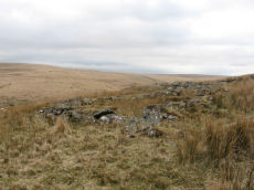
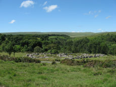
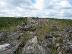
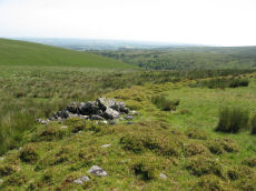
Walkhampton Enclosed Settlement
Prehistoric Dartmoor Walks: Dartmoor Site: Walkhampton and Yes Tor Bottom Settlements
OS Map: SX 56772 72867
HER: MDV4964
Megalithic Portal: 45325
Short Name: ES Walkhampton
Notes: "Hut circles 550m s of foggintor quarries. A very fine settlement, set within a well built and substantial enclosure wall, enclosing an area of some 1.0ha. Five hut circles occur within the enclosure varying between 6-10m in diam ... Outside the enclosure to the w are five further huts of similar dimensions - again one of these shows sign of alteration. Under moorland grass." The site was excavated in 1897 by Burnard and Baring-Gould.
Nearest Bus Stop: Princetown Dartmoor Visitor Centre (2.4 km) [Route: 98,171(20/07/26 to 19/09/26)]
Nearby sites: SX 56772 72867
White Hill Enclosed Settlement
OS Map: SX 62656 90597
HER: MDV6887
Megalithic Portal: 36009
Short Name: ST:WhiteHill
Nearest Bus Stop (Minor): Belstone Car Park (3.3 km) [Route: 670]
Nearest Bus Stop (Major): Ramsley (3.4 km) [Route: 670,671,6A]
Nearby sites: SX 62656 90597
Whittenknowles Rocks Enclosed Settlement
OS Map: SX 5855 6705
HER: MDV3995
Megalithic Portal: 19400
Short Name: ES Whittenknow
Nearest Bus Stop: Meavy Primary School (4.1 km) [Route: 56]
Nearby sites: SX 5855 6705
Willings Walls (North) Enclosed Settlement
OS Map: SX 57934 65795
HER: MDV3343
Short Name: ES:WillingsN
Notes: HER: Settlement consisting of at least seven irregular enclosures containing the remains of at least twelve hut circles and a later longhouse, lying at the end of the short ridge between Spanish Lake and Hentor Brook.
Nearest Bus Stop: Meavy Primary School (3.8 km) [Route: 56]
Nearby sites: SX 57934 65795
Wistman's wood Settlement
OS Map: SX 6125 7750
HER: MDV5933
Megalithic Portal: 42854
Alternate name: Wistman's wood Settlement
Short Name: ST:Wistmans
Nearest Bus Stop (Minor): Powder Mills (1.9 km) [Route: 171(20/07/26 to 19/09/26)]
Nearest Bus Stop (Major): Two Bridges Hotel (2.5 km) [Route: 98,171(20/07/26 to 19/09/26)]
Nearby sites: SX 6125 7750
Yealm Steps Enclosed Settlement
OS Map: SX 62065 63607
HER: MDV4273
Megalithic Portal: 45575
Short Name: ES Yealm Steps
Notes: "A fine example of enclosure and hut circles. Extensive prehistoric settlement area. Two villages contiguous, the larger pound a development of the smaller. Pound walls and those of huts consist of stone and turf. At least 22 huts within the enclosure. To the north and south of the pounds are scatters of isolated huts generally much larger than the enclosed huts. On the south there are remains of fields or paddocks. Rough moorland."
Nearest Bus Stop: Cornwood Crossways (4.3 km) [Route: 59]
Nearby sites: SX 62065 63607