
The Standing Stones of Dartmoor
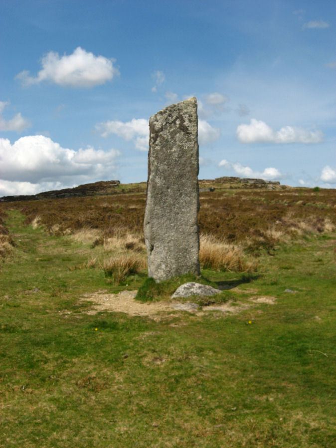
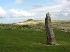
Photo: Laughtor Man Standing Stone
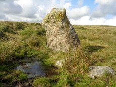
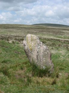
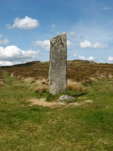
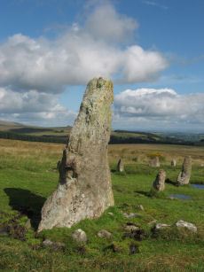
There are numerous prehistoric monuments on Dartmoor such as stone rows and stone circles that consist of standing stones. However, the term menhir, or standing stone, is usually reserved for those that are megalithic in size and stand in isolation from any other monuments or burial mounds. With such a definition there are very few standing stones to be found today on Dartmoor. In fact only three remain standing; Beardown Man on Devil’s Tor a kilometre from Cowsic Head, the Hanging Stone on Lee Moor, and the Harbourne Head standing stone about a mile east of the Avon Dam Reservoir. All of these are in isolated places, unconnected to other monuments, and the stones are in unlikely settings for boundary or marker stones [Butler p. 220].
Undoubtedly, there were once many more standing stones. The word “Longstone”, or equivalently, “Langstone” appears in many place names on Dartmoor and these could well refer to standing stones that have long disappeared [Worth p.271]. For example, Longstone Hill, about 1km to the east of the Meldon reservoir has what may well be a fallen menhir on the summit [Butler p.220, Newman p. 36]. This could also apply to Quintins Man in Lydford, “man” being a derivation from “maen” for stone or menhir, hence names such as Beardown Man. The Quintins Man is actually a cairn with no standing stone known in the historical records but it is quite conceivable that it has long been lost or removed.

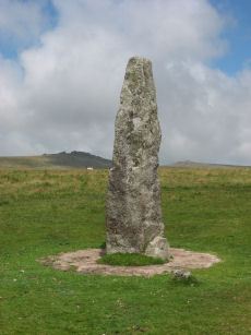
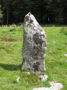
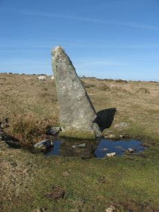
Worth allows for the broadening of the term menhir to include significant standing stones associated with stone rows. Many of the stone rows consist of small stones with a cairn at one end and a significantly larger terminal stone at the other. Some of these terminal stones are truly megalithic in size. The three row terminals at Drizzlecombe are notable examples, one of which is the tallest on Dartmoor. The other notable examples being the Shovel Down Longstone, the Piles Hill longstone that terminates the Butterdon stone row, the Langstone on Langstone Moor and the Laughter Man. Petit suggests that the lower end of the Burfurd Down stone row would have originally been of similar proportions to these longstones. As the row descends the hill on to more level ground it goes beyond the new take wall and ends with a stone that is 4ft wide at the base and rises over 2ft out of the ground at an angle. A 7ft long slab that tapers to a breadth of 2.5ft has been cut from this stone and lies on the ground nearby [Petit p.135]. Along with these longstones can be added the example at the Merrivale complex and the White Moor Stone which lies a short distance from the Little Hound Tor stone circle.
It is not certain that all of these standing stones are actually prehistoric, some, like the White Moor Stone and the Shovel Down longstone have become boundary stones in historic times. The Shovel Down longstone is mentioned in the Perambulation of Dartmoor in 1240 which would suggest that it at least predates 1240. Whilst it is difficult to prove the age of these stones it seems most likely that those located at the end of stone rows are of the same date as the rows. The Laughter Man longstone is one of the exceptional menhirs in that it also marks a cairn which was excavated in 1903 when the stone was restored. A number of these menhirs were restored by Baring-Gould and Burnard and the Dartmoor Exploration Committee.
Worth also mentions other "exceptionally large" stones in stone rows leading to cairns, whilst making it clear that they are not true menhirs, and adds some examples where the stones in a stone row approaching the cairn get larger to the point that they stand out for their size. These include the stone nearest the cairn end of the Assacombe row and the westernmost stone in the Hingston Hill (Down Tor) row. In this context Worth also mentions the massive fallen slabs that would have been at the end of the double row that leads to the Shovel Down Fourfold cairn circle.
With more emphasis on the megalithic size rather than scientific definition, the massive stones in the Challacombe and Hurston rows are perhaps worthy of a mention. To this could also be added the stones of the Staldon and Piles Hill rows and those recently found on Cut Hill - but we will exclude these as they are rows of large stones rather than examples of individual outstanding stones. We should probably also exclude the largest stone in the Scorhill Circle as it does not meet the usual criteria of being considered a menhir - but purely on the unscientific basis of its notable and exceptionally large size for a stone in a Dartmoor circle it is included in the listing below.
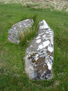
There are other stones worthy of a mention; the Maximajor stone (now damaged and replaced) on Mardon Down, the Three Boys (again part of the Shovel Down complex), a standing stone on Butterdon Hill (near Moretonhampstead) and Butler mentions a possible fallen menhir in an oval embankment on White Ridge not far from the Grey Wethers. There are also two massive recumbent slabs half a mile north-east of the summit of Butterdon Hill on Beacon Plain. They lie about 50yds apart on grass moorland in an area where there are only a few surface stones. Pettit suggests they were probably moved to their current location from Hangershell rock. Both are over 18ft in length and if standing would be larger than the Drizzlecombe menhir [Petit p.148]. It is not clear whether they were ever erected. Another curious candidate for a prehistoric standing stone is to be found embedded in a wall in a pub in South Zeals, namely in the Oxenham Arms (see coverage on Legendary Dartmoor website).
Possibly one of the largest standing stones described on Dartmoor was reported by Wilkinson in his 1862 article on British Remains on Dartmoor [Wilkinson p. 36-7]. This stone has long since disappeared. According to Wilkinson the Hart Tor double stone row was "terminated by a large monolith, now fallen, measuring about 25 feet long by 2 feet and 3 inches". According to Butler it would have been "a truly gigantic terminal pillar, far larger than any that has survived on the Moor". In 1879 W.C. Lukis mapped the site and in 1881 described a "menhir which has fallen, 17 feet 9 inches long", Whilst considerably shorter than Wilkinson's measurements this would still be the largest menhir on Dartmoor [Lukis p.476]. Lukis also refers to another fallen menhir terminating the single row on Hart Tor which was apparently 12 feet 3 inches in length which is not much shorter than the tallest Drizzlecombe menhir at 13 feet and 9 inches. For further coverage of the Hart Tor site, see Hart Tor Stone Row & Cairn Circle.
There are of course numerous other “standing stones” on Dartmoor which date from historic times. The numerous crosses and boundary stones hold a fascination in their own right but are beyond the scope of our coverage.
Bibliography & references
Butler, J. Dartmoor Atlas of Antiquities: Vol. 5. - The Second Millennium B.C. (Devon Books, 1997)
Lukis, W.C. Report on the Monuments of Dartmoor in Proceeding of the Society of Antiquaries Vol. VIII. pp.285-292 & pp.470-481 (1881)
Newman, Phil The Field Archaeology of Dartmoor (English Heritage, 2011)
Pettit, Paul. Prehistoric Dartmoor (David & Charles, 1974)
Wilkinson J. Gardner. British Remains on Dartmoor in Journal Brit. Arch. Assoc. xviii. pp.22-53, pp.111-132 (1862)
Worth, R.H. Worth's Dartmoor (David & Charles, 1971)
External Links & Resources
The NMRs can be searched on the English Heritage Pastscape website. The simplest method is to use a location search and reduce the range to 250m to narrow the results (increase to 500m if site not found). The Megalithic Portal is another great resource for looking up sites. A detailed listing of possible menhirs, some quite obscure, can be found on the Prehistoric Monuments of Dartmoor website. An excellent discussion of menhirs can be found on the Legendary Dartmoor website.
Pastscape: National Monuments Records
Prehistoric Monuments of Dartmoor: A List Dartmoor Standing Stones
Megalithic Portal: Search Page
Legendary Dartmoor: The Granite Sentinels
Legendary Dartmoor: The Oxenham Arms Menhir
Listing of Dartmoor Standing Stones
About the Database Listings
Details of archaeological sites used to be kept in the Sites and Monuments Records (SMRs). These are now held in National Monument Records (NMRs) maintained by English Heritage although these in turn are being merged into Historic Environment Records (HERs). The NMRs contains details of the site and will often include field notes, a limited bibliography and other useful information. Another rich source of such information is Bill Radcliffe's Prehistoric Monuments of Dartmoor (PMD) website. The records below were compiled independently from books and journals and then matched to the NMR records and then cross-referenced with any corresponding PMD records to ensure accuracy. Each record has a link to corresponding NMR and PMD records, a link to the location on the Ordnance Survey map, a photo (if available) and a link to relevant coverage on Prehistoric Dartmoor Walks and a link giving a listing of nearby sites. The HER records are not included as they do not yet have much information but they can be looked up via the PMD records. The author would like to thank Bill Radcliffe for the helpful correspondence whilst checking records. See also: Database and Web Search Tools
- NMR = Pastscape National Monument Record
- HER = Historic Environment Record
- PMD = Prehistoric Monuments of Dartmoor Record
- DPD = Discover Prehistoric Dartmoor page number
- Short Name is named used in GPS listings
Note on menhirs: we have used a very loose definition of a "standing stone" which is broadened to include some stones of a "megalithic proportion" which are not strictly menhirs. Some of the entries are of recumbent stones or suggested menhirs or of locations thought to relate to menhirs.
Default listing is by Site Name, click here to order instead by: Site Name, OS
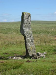
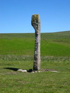
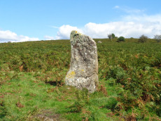
Langstone Moor Standing Stone
Prehistoric Dartmoor Walks: Dartmoor Site: Langstone Moor Stone Circle, Stone Row & Settlements
OS Map: SX 55023 78742
HER: MDV4225
Megalithic Portal: 17504
PMD: Langstone Moor Standing Stone
Short Name: SS Langstone
Butler map: 30.12
Butler Vol 5: p.230
DPD: 13
Dimensions (m): 2.76
Notes: The Langstone standing stone is 2.76m high and can be seen from some distance. It was restored in its original socket in 1893. The Langstone is close to a stone row consisting of very small stones. The Langstone standing stone and also the stone circle were used for target practice by American troops who were stationed nearby during the second world. Bullet holes can be seen on the Langstone standing stone. Lethbridge pp.13-14. Breton (p.17) The stone is composed of local gabbro, and was formerly prostrate, but His Grace the Duke of Bedford has re-erected it in its original socket-hole.
Nearest Bus Stop: Merrivale Dartmoor Inn (3.6 km) [Route: 98,171(20/07/26 to 19/09/26)]
Nearby sites: SX 55023 78742
Merrivale Standing Stone
Prehistoric Dartmoor Walks: Dartmoor Site: Merrivale Ceremonial Complex [Photo Set 2]
OS Map: SX 55359 74599
HER: MDV53395
Megalithic Portal: 115
PMD: Merrivale Standing Stone
Short Name: SS Merrivale
Butler map: 44.8.4
DPD: 17
Dimensions (m): 3.2
Notes: "Two Bronze Age standing stones with a disturbed cairn and a number of small earth fast stones. Located in open generally clitter-free moorland. Only one of the two stones still stands; it is 3.2 metres high and tapers from the base which is 0.7 by 0.5 metres in section. Whether the stone was once the focus or terminus of a stone rows is uncertain. The second stone is now fallen, it is 2.2 metres long, up to 0.4 metres wide and 0.3 metres thick. An adjacent 0.3 metre deep pit may be its socket hole. "
Nearest Bus Stop: Merrivale Dartmoor Inn (0.8 km) [Route: 98,171(20/07/26 to 19/09/26)]
Nearby sites: SX 55359 74599
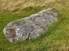
Merrivale Recumbent Slab Standing Stone
Prehistoric Dartmoor Walks: Dartmoor Site: Merrivale Ceremonial Complex [Photo Set 2]
OS Map: SX 55371 74596
HER: MDV53396
Short Name: SS-Merrivale 2
Butler map: 44.8.4
DPD: 17
Dimensions (m): 3.2
Notes: "The second stone is now fallen, it is 2.2 metres long, up to 0.4 metres wide and 0.3 metres thick. An adjacent 0.3 metre deep pit may be its socket hole." According to Butler it was "erected in 1895 in the pit alongside, toppling again a few years later". Breton (p.14) "A smaller menhir is near ..." [to the Merrivale Longstone].
Nearest Bus Stop: Merrivale Dartmoor Inn (0.8 km) [Route: 98,171(20/07/26 to 19/09/26)]
Nearby sites: SX 55371 74596
Leeden Hill Standing Stone
Prehistoric Dartmoor Walks: Dartmoor Walk: Sharpitor area Stone Rows and Cists
OS Map: SX 56015 71286
HER: MDV28499
Megalithic Portal: 45567
PMD: Leeden Hill Standing Stone
Short Name: SS Leeden Hill
Butler map: 45.
Dimensions (m): 1.25 x 0.55 x 1.3
Notes: Possibly a prehistoric standing stone but may also be a much later marker since there are at least three similar stones in a line towards Ingra Tor set out at wide intervals as if to mark a boundary
Nearest Bus Stop: Walkhampton Memorial (3.1 km) [Route: 55,56]
Nearby sites: SX 56015 71286
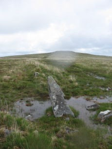
Longstone Hill Standing Stone
OS Map: SX 56725 90890
HER: MDV5571
Megalithic Portal: 36422
PMD: Longstone Hill Standing Stone
Short Name: SS Longstone
Butler map: 42.
Butler Vol 5: p.220
DPD: 156
Dimensions (m): 1.75 x 0.8 x 0.45
Notes: Possible recumbent longstone on summit of Longstone Hill, east of Meldon Reservoir. Suggested as possible menhir by Butler and Newman. Historic England:A sinuous 50 metres long, 2 metres wide and 0.25 metres high bank lying within the monument leads towards a large recumbent stone. This stone measures 1.75 metres long, 0.8 metres wide and 0.45 metres thick and is the only large stone visible on Longstone Hill. It has been suggested that this may be the longstone which once stood upright to give the hill its name. The presence of this stone, which would have been broadly contemporary with the cairns, provides additional support for the ritual and funerary character ascribed to many cairns within the group.
Nearest Bus Stop: Sourton Windard Terrace (3.4 km) [Route: 118]
Nearby sites: SX 56725 90890
Hanging Stone Standing Stone
OS Map: SX 58372 63688
HER: MDV2423
Megalithic Portal: 45568
The Stone Rows of GB: Lee Moor South
PMD: The Hanging Stone
Alternate name: The Hanging Stone Standing Stone
Short Name: SS Hanging
Butler Vol 5: p.53
DPD: 59
Dimensions (m): 2.2
Notes: Located on Lee Moor. "The 'Hanging Stone' or 'Leaning Rock', 7ft 9ins in length, but because of the stone being 38o out of the vertical, its vertical height is only 6ft 9ins. It measures 3ft 7ins by 1ft 10ins at the base, and is incised on one face with the letters "CB" showing that at one time it was used as a bound-post. It is believed to be prehistoric." TDA Vol. 72 1940 pp. 192-3 (R Hansford Worth). See also, Legendary Dartmoor: The Hanging Stone.
Nearest Bus Stop: Lee Moor Clearview (2.1 km) [Route: 59]
Nearby sites: SX 58372 63688
Hingston Hill (Down Tor) Standing Stone
Prehistoric Dartmoor Walks: Dartmoor Site: Down Tor Stone Row and Cairn Circle
OS Map: SX 58702 69276
HER: MDV3502
Megalithic Portal: 1901
PMD: Down Tor Standing Stone
Short Name: SS Down Tor
Butler map: 47.12
DPD: 29
Dimensions (m): 2.8
Notes: "A stone alignment and cairn, situated on a saddle 620 metres east of Down Tor. The alignment is orientated east-north-east to west-south-west, running for 316 metres and containing at least 174 stones, with the tallest at either end. The westernmost stone stands 2.8 metre high, the easternmost stone stands 1.6 metres high, and the remainder vary between 1 metre and 0.2 metres in height. The westernmost stone, and an unknown number of others, were re-erected by Baring-Gould and Burnard in 1890."
Nearest Bus Stop: Princetown Dartmoor Visitor Centre (4.2 km) [Route: 98,171(20/07/26 to 19/09/26)]
Nearby sites: SX 58702 69276
Drizzlecombe S. Standing Stone
Prehistoric Dartmoor Walks: Dartmoor Site: Drizzlecombe Ceremonial Complex (Photos 1)
OS Map: SX 59057 66868
HER: MDV14778
Megalithic Portal: 16927
PMD: Drizzlecombe Standing Stones
Short Name: SS Drizzle S
Butler map: 49.19
DPD: 40
Dimensions (m): 3.2 x 1.8 x 0.4
Notes: Terminal stone of the southern double row at Drizzlecombe. The standing stone at the southwest end measures 1.8 metres by 0.4 metres and is 3.2 metres high. Re-erected in 1893. Lethbridge Row A pp.38-42. Diagram p.38. Worth's Row 17/Row A.
Nearest Bus Stop: Meavy Primary School (4.6 km) [Route: 56]
Nearby sites: SX 59057 66868
Drizzlecombe N.W. Standing Stone
Prehistoric Dartmoor Walks: Dartmoor Site: Drizzlecombe Ceremonial Complex (Photos 1)
OS Map: SX 59134 66988
HER: No record
Megalithic Portal: 16929
PMD: Drizzlecombe Standing Stones
Short Name: SS Drizzle NW
Butler map: 49.19
DPD: 40
Dimensions (m): 2.4 x 0.8 x 0.3
Notes: Terminal for Drizzlecombe NW stone row. Re-erected in 1893. Lethbridge Row C. pp.38-42. Diagram p.38. NB. This website had previously matched this site with the HER record 3377. That record now clearly refers to the NE stone - although that may not have previously been the case. There is no HER record for this site now. Worth's Row 18/Row B. Previously listed here with a grid referecne of SX 59200 67020 which is quite a bit out.
Nearest Bus Stop: Meavy Primary School (4.7 km) [Route: 56]
Nearby sites: SX 59134 66988
Drizzlecombe N.E. Standing Stone
Prehistoric Dartmoor Walks: Dartmoor Site: Drizzlecombe Ceremonial Complex (Photos 1)
OS Map: SX 59215 67005
HER: MDV3377
Megalithic Portal: 16928
PMD: Drizzlecombe Standing Stones
Short Name: SS Drizzle NE
Butler map: 49.19
Butler Vol 5: p.230
DPD: 39
Dimensions (m): 4.2
Notes: Largest standing stone on Dartmoor - terminal for Drizzlecombe stone row. It is 4.2m in height with a distinctive bulging profile at the top. Worth suggests it was probably dragged here from Higher Hartor Tor about 1km away. Re-erected in 1893. Lethbridge Row B. pp.38-42. Diagram p.38. Worth's Row 19/Row C. Used to be listed as HER 14781 perhaps now deleted as an HER duplicate record.
Nearest Bus Stop: Meavy Primary School (4.8 km) [Route: 56]
Nearby sites: SX 59215 67005
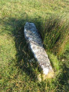
Shell Top S.W. stone row Standing Stone
OS Map: SX 59420 63210
HER: MDV131180
Short Name: SS:ShellTopSW
Butler map: 51.9
Dimensions (m): 2.7
Notes: HER refering to Butler: Fallen longstone 2.7 metres long at the northern end of the stone row to the south-west of Shell Top.. The ngr is estimated from location of row and cairn.
Nearest Bus Stop: Lee Moor Clearview (2.5 km) [Route: 59]
Nearby sites: SX 59420 63210
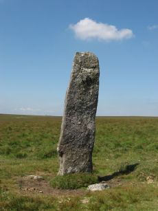
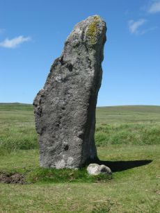
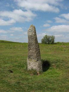
Beardown Man Standing Stone
OS Map: SX 59616 79634
HER: MDV4200
Megalithic Portal: 4144
PMD: Beardown Man Standing Stone
Short Name: SS BeardownMan
Butler map: 29.15
Butler Vol 5: p.220
DPD: 108
Dimensions (m): 3.4 x 1.0 x 0.4
Notes: A Bronze Age standing stone measuring 3.4m high, 1m by 0.4m in section and in good condition. One of the few isolated menhirs on Dartmoor. See also, Legendary Dartmoor: Dartmoor's Beardown Man. Lethbridge diagram p.107, photo p.108.
Nearest Bus Stop (Minor): Powder Mills (4.5 km) [Route: 171(20/07/26 to 19/09/26)]
Nearest Bus Stop (Major): Two Bridges Hotel (4.8 km) [Route: 98,171(20/07/26 to 19/09/26)]
Nearby sites: SX 59616 79634
Halstock Standing Stone
OS Map: SX 60461 93334
HER: MDV13056
Short Name: SS Halstock
Dimensions (m): 1.4 m
Notes: HER: Small standing stone north of East Bowden, near three prehistoric cairns. Gerrard p.63: There are possible standing stones at Halstock and Butterdon Down. Two of the cairns (East Bowden 2 and 3) align on the stone.
Nearest Bus Stop: Okehampton Railway Station (1.7 km) [Route: 118,306,6A]
Nearby sites: SX 60461 93334

Quintins Man Cairn
OS Map: SX 62101 83873
HER: MDV6765
Megalithic Portal: 45860
PMD: Quintins Man
Short Name: SSxQuintinsMan
Butler map: 34.1
Notes: "A cairn. The name implies a standing stone, but there is no knowledge of one in living memory." [worth] See also, Legendary Dartmoor: Dartmoor's Quintin's Man
Nearest Bus Stop: Postbridge Post Office (5.7 km) [Route: 98,171(20/07/26 to 19/09/26)]
Nearby sites: SX 62101 83873
Sittaford Circle Outlier Standing Stone
OS Map: SX 63053 82805
HER: MDV110432
Megalithic Portal: 35327
Short Name: SS Sittaford
Notes: Sittaford Circle Outlier
Nearest Bus Stop: Postbridge Post Office (4.3 km) [Route: 98,171(20/07/26 to 19/09/26)]
Nearby sites: SX 63053 82805
White Moor Stone Standing Stone
Prehistoric Dartmoor Walks: Dartmoor Site: Little Hound Tor Stone Circle
OS Map: SX 63359 89491
HER: MDV4391
Megalithic Portal: 10326
PMD: White Moor Stone
Short Name: SS White Moor
Butler map: 40.5
Butler Vol 5: p.53
DPD: 154
Dimensions (m): 1.7 x 0.8 x 0.45
Notes: The White Moor stone lies 160m to the SE of the Little Hound Tor stone circle and it is thought to be contemporary with the circle but probably out of position having been re-erected at some point. It is now a boundary marker.
Nearest Bus Stop (Minor): Throwleigh Cross (3.7 km) [Route: 670]
Nearest Bus Stop (Major): Ramsley (4.0 km) [Route: 670,671,6A]
Nearby sites: SX 63359 89491
Burford Down Standing Stone
Prehistoric Dartmoor Walks: Dartmoor Site: Burford Down stone row and cairns
OS Map: SX 63703 60687
HER: MDV4333
Megalithic Portal: 1463
PMD: Burford Down Stone Row
Short Name: SS BurfordDown
Butler map: 54.17
DPD: 70
Dimensions (m): 2.7
Notes: "The alleged blocking stone noted by Parsons measures 2.7m by 1.0m and has been split by drilling." TDA Vol. 85 (1953) pp. 145-147 (Hamlyn Parsons).
Nearest Bus Stop: Cornwood Crossways (3.4 km) [Route: 59]
Nearby sites: SX 63703 60687
White Ridge Standing Stone
OS Map: SX 64162 82653
HER: MDV6771
Megalithic Portal: 51338
PMD: South Teignhead
Alternate name: South Teignhead Standing Stone
Short Name: SS White Ridge
Butler map: 35.18
Dimensions (m): 2.7 x 0.7 x 0.2
Notes: Possible recumbent standing stone. "A small circular 'pound' about 350 yards (sic) SE of Grey Wethers. It measures 75ft (N-S) by 66ft; the bank composed of small stone and earth is 6-8ft wide and 3ft high. An entrance on the W has one door jamb standing; this was excavated but nothing was found except a very fine flat stone on the subsoil which measured 9ft long by 3-4ft wide. Trial pits were dug inside the enclosure without success." TDA Vol. 34 pp.164 (1902)
Nearest Bus Stop (Minor): Warren House Inn (3.7 km) [Route: 171(20/07/26 to 19/09/26)]
Nearest Bus Stop (Major): Postbridge Post Office (3.8 km) [Route: 98,171(20/07/26 to 19/09/26)]
Nearby sites: SX 64162 82653
Butter Brook Standing Stone
Prehistoric Dartmoor Walks: Dartmoor Walk: The Neolithic tombs of Cuckoo Ball & Corringdon Ball
OS Map: SX 64747 59301
HER: MDV13095
Megalithic Portal: 45565
PMD: Butterbrook Standing Stone
Short Name: SS ButterBrook
Dimensions (m): 2.03 x 1.77
Notes: The stone is easy to approach from the dry ground to the south but just beyond the stone to the north is marshland. A standing-stone, possibly prehistoric, near Butter Brook (near Harford) is 2.03m long and has a standing height of 1.77m. The stone is located towards the north of the eastern side of the plantation around Butterbrook reservoir. [Entry no. 70 in An archaeological check-list for Harford, Devon Archaeological Society/DCRA publications no. 11 (1982)]
Nearest Bus Stop: Ivybridge BP Garage (Stop B) (3.4 km) [Route: 38]
Nearby sites: SX 64747 59301
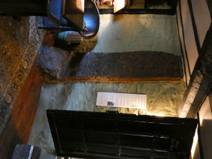
Oxenham Arms Standing Stone
Prehistoric Dartmoor Walks: Dartmoor Site: The Oxenham Arms standing stones
OS Map: SX 65014 93606
HER: MDV13065
Megalithic Portal: 8401
PMD: Oxenham Arms
Short Name: SS OxenhamArms
Notes: "The Oxenham Arms, now an inn, is the former manor house and home of the Burgoyne family. A courtyard plan house, it was originally a two-room-and-through passage plan. An interesting feature is an enormous upright slab of granite built into the inner wall of the rear parlour. This looks very much like a prehistoric standing stone and it seems that the house was built around it".
Nearest Bus Stop: South Zeal Oxenham Arms (0.1 km) [Route: 178]
Nearby sites: SX 65014 93606
Sharp Tor Standing Stone
OS Map: SX 651 619
HER: MDV5709
Short Name: SS:Sharp Tor
Notes: NGR is estimated. Source Worth, HER: Sharp tor. Alongside one of the modern boundary stones lies what may be a fallen menhir. See The Dartmoor Menhirs p.193
Nearest Bus Stop: Cornwood Crossways (5.2 km) [Route: 59]
Nearby sites: SX 651 619
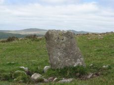
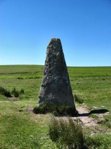
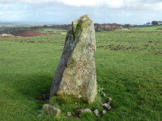
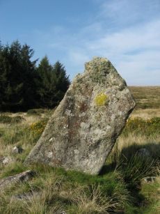
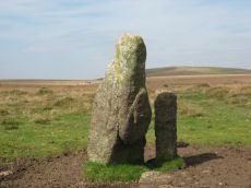
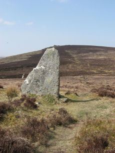
Laughtor Man Standing Stone
Prehistoric Dartmoor Walks: Dartmoor Site: Laughter Tor Stone Row
OS Map: SX 65223 75389
HER: MDV6001
Megalithic Portal: 2017
PMD: Laugh Tor Man
Short Name: SS Laughtor
Butler map: 28.12
Butler Vol 5: p.215 & Fig.149
DPD: 122
Dimensions (m): 2.4
Notes: The longstone is 2.4 m high and was found prostrate on a cairn which was excavated by Burnard. The cairn contained "a great quantity of charcoal and peat ashes". The longstone was restored in 1903. A double stone row heads to the longstone. Breton p.41 a huge menhir I found in June 1913, lying on the ground. It was then 16 ft long, but 4 ft. had been broken off. It was re-erected by the late Rev S. Baring Gould, with the Duchy appliances, and he told me that they could not join the two pieces, so he erected it as it now stands; it is 8.5 ft high, 2ft 6in wide and 1.5 ft thick. The stone row runs E. 720 ft.. See also, Legendary Dartmoor: The Prehistoric Complex of Laughter Tor
Nearest Bus Stop: Postbridge Bellever (2.0 km) [Route: 98]
Nearby sites: SX 65223 75389
Piles Hill Standing Stone
Prehistoric Dartmoor Walks: Dartmoor Site: Piles Hill Double Stone Row & Cairns
OS Map: SX 65433 60746
HER: MDV5653
Megalithic Portal: 10003
PMD: Piles Hill Standing Stone
Short Name: SS Piles Hill
Butler map: 53.8
DPD: 77
Dimensions (m): 2.5
Notes: The fallen menhir on Piles Hill: "The 'Longstone' is a block of very coarse-grained pinkish granite. It is now 2.5m long and of rough rectangular section tapering from a base formerly about 0.4m. by 0.7m. which has been squared and snapped by drilling. The stone lies in a northwest to southeast direction. To its northeast side there is a boundary stone erected in 1803 and shaped by drilling. It is of identical stone and appears to have been fashioned from the 'Longstone' which would therefore have originally been some 4.5m long." Lethbridge p.77
Nearest Bus Stop: South Brent Pool Park (4.8 km) [Route: 38]
Nearby sites: SX 65433 60746
Scorhill Circle Standing Stone
Prehistoric Dartmoor Walks: Dartmoor Site: Scorhill Stone Circle
OS Map: SX 6546 8738
HER: MDV6122
Megalithic Portal: 540
PMD: Scorhill Stone Circle
Short Name: SS Scorhill
Butler map: 38.8
DPD: 146
Dimensions (m): 2.25
Notes: Largest stone in the Scorhill Circle. In strict terms this would not typically be classified as a "standing stone" as it is a member of the stone circle. It is the largest stone in a Dartmoor stone circle at 8 feet 2 inches tall.
Nearest Bus Stop (Minor): Wonson Telephone Box (2.9 km) [Route: 670]
Nearest Bus Stop (Major): Chagford The Square (4.6 km) [Route: 173,178,671]
Nearby sites: SX 6546 8738
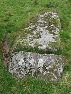
Beacon Plain A Standing Stone
Prehistoric Dartmoor Walks: Dartmoor Walk: The Neolithic tombs of Cuckoo Ball & Corringdon Ball
OS Map: SX 65838 59189
HER: MDV2888
Megalithic Portal: 44532
The Stone Rows of GB: Butterdon East
PMD: Beacon Plain
Short Name: SS Beacon Pl A
Butler map: 53.8
Butler Vol 5: p.216 & Fig.150
DPD: 79
Dimensions (m): 6.4 x 1.93 x 0.76
Notes: "One of two large granite blocks situated some 500 meters east of Hangershell Rocks. May be fallen standing stones or stones brought to the site but never erected. This western stone lies 55 meters from the other and tapers towards its northern end. Between the two are traces of two other stones, and the fact that they form a straight line lends weight to the argument that they are fallen menhirs. This western stone was excavated in august 1968, and groups of small stones were found at the broad end and along the w side as if to receive the stone when it was erected." For more on that see coverage on the SRGB and on PMD. See also HER record MDV2883 and also Butterdon East Stone Row and Beacon Plain B Standing Stone.
Nearest Bus Stop: Ivybridge BP Garage (Stop B) (3.7 km) [Route: 38]
Nearby sites: SX 65838 59189
Beacon Plain B Standing Stone
Prehistoric Dartmoor Walks: Dartmoor Walk: The Neolithic tombs of Cuckoo Ball & Corringdon Ball
OS Map: SX 65886 59210
HER: MDV2883
Megalithic Portal: 44532
The Stone Rows of GB: Butterdon East
PMD: Beacon Plain
Short Name: SS Beacon Pl B
Butler map: 53.8
Butler Vol 5: p.216 & Fig.150
DPD: 79
Dimensions (m): 5.4 x 0.7 x 0.5
Notes: "There are two possible menhirs, on Beacon Plain, 500 yards east of Hangershell Rock. The more easterly stone measures 18 feet 4 inches in length. The other stone lies 57 yards away on a bearing 26 degrees south of west. It is 18 feet in length, 5 feet 6 inches wide at one end, and tapers to a blunt point. The stones are completely isolated on a grass moor, and have none of the characteristics of surface boulders. If they were menhirs they are the largest known on Dartmoor." There are suggestions these two stones are ends of a short stone row with a smaller stone in between. For more on that see coverage on the SRGB and on PMD. See also HER record MDV2888 and also Butterdon East Stone Row and Beacon Plain A Standing Stone.
Nearest Bus Stop: Ivybridge BP Garage (Stop B) (3.8 km) [Route: 38]
Nearby sites: SX 65886 59210
Shovel Down Fourfold Circle Standing Stone
Prehistoric Dartmoor Walks: Dartmoor Site: Shovel Down Ceremonial Complex
OS Map: SX 65958 86033
HER: MDV6158
Megalithic Portal: 3464
PMD: Fourfold circle
Alternate name: Fourfold Circle Standing Stone
Short Name: SS Shovel Down
Butler map: 36.6
DPD: 143
Barrow Report: 56
Dimensions (m): 3.4
Notes: "The south end [of the double row] is aligned on a cairn 'Fourfold Circle' (SX 68 NE 17) and separated from it by two massive fallen stones, one 'needle-shaped' and similar to the 'Longstone' (SX 68 NE 39), southern terminal of stone row 'E'."
Nearest Bus Stop (Minor): Wonson Telephone Box (3.8 km) [Route: 670]
Nearest Bus Stop (Major): Chagford The Square (4.4 km) [Route: 173,178,671]
Nearby sites: SX 65958 86033
Three Boys Standing Stone
OS Map: SX 66028 85486
HER: MDV6180
Megalithic Portal: 10369
The Stone Rows of GB: Shoveldown 6
PMD: Three Boys
Short Name: SS Three Boys
Butler map: 36.6
Notes: Terminal for stone row - one of 3 stones. 3 standing stones, of which only one remains; sometimes claimed as remains of burial chamber. This record has two entries, this one as a standing stone as widely reported, but also as reported cairn or tomb, see Three Boys Reported Cairn, SiteID=1268
Nearest Bus Stop (Minor): Wonson Telephone Box (4.3 km) [Route: 670]
Nearest Bus Stop (Major): Chagford The Square (4.5 km) [Route: 173,178,671]
Nearby sites: SX 66028 85486
Shovel Down Long Stone Standing Stone
Prehistoric Dartmoor Walks: Dartmoor Site: Shovel Down Ceremonial Complex
OS Map: SX 66031 85683
HER: MDV6149
Megalithic Portal: 10378
PMD: Shovel Down
Short Name: SS Long Stone
Butler map: 36.6
Butler Vol 5: p.56 & Fig.34
DPD: 140
Dimensions (m): 3.4
Notes: The Long Stone has been used as a boundary stone but it appears to be the terminal stone for a Bronze Age stone row and it may be of a contemporary date. Grinsell [Folklore 1976]: At the beating of the bounds of Gidleigh Common, the first man to reach the Long Stone is (or was) given a money prize. Fielden 1933. The current author has been informed this tradition continues. See also, Legendary Dartmoor: The Shoveldon Longstone
Nearest Bus Stop (Minor): Wonson Telephone Box (4.1 km) [Route: 670]
Nearest Bus Stop (Major): Chagford The Square (4.4 km) [Route: 173,178,671]
Nearby sites: SX 66031 85683
Assycombe Standing Stone
Prehistoric Dartmoor Walks: Dartmoor Site: Assycombe Double Stone Row
OS Map: SX 66101 82649
HER: MDV6537
Megalithic Portal: 1738
PMD: Assycombe Standing Stone
Short Name: SS Assycombe
Butler map: 35.19
DPD: 135
Dimensions (m): 2.0
Notes: Bronze Age stone row and cairn, Assycombe. The double stone row is 120m long terminating in the cairn at the North-East end. The South-West end is blocked by a stone 2.0m high. The largest stone, 2m high, lies at the E end and was re-erected re-erected by Baring-Gould in 1892 or 1893. The cairn is 8.4m in diameter and 0.6m high. Breton p.68.
Nearest Bus Stop (Minor): Warren House Inn (2.2 km) [Route: 171(20/07/26 to 19/09/26)]
Nearest Bus Stop (Major): Postbridge Post Office (4.0 km) [Route: 98,171(20/07/26 to 19/09/26)]
Nearby sites: SX 66101 82649
Heath Stone Standing Stone
Prehistoric Dartmoor Walks: Dartmoor Site: Hurston Ridge Double Stone Row
OS Map: SX 67133 83755
HER: MDV6650
Megalithic Portal: 14933
Short Name: SS Heath Stone
Butler map: 25.
Dimensions (m): Almost 3?
Notes: The original Heath Stone was a boundary stone which was referred to in the Perambulation of the Forest of Dartmoor in 1240 and some very early maps. According to Butler (Vol. 2 Map 25 p.32) the stone carved with a biblical inscription in 1970 that is currently known as the Heath Stone is unlikely to have been the original Heath Stone as it is in a useless position to be of any use as a boundary stone. The stone was not included in maps from the 18th century and then reappeared in a different location. It is doubtful that the current stone is the original or that it is prehistoric. Crossing suggests that the large standing stone in the Hurston Ridge stone row is the actual Heath Stone. See also, Legendary Dartmoor: The Dartmoor Heathstone
Nearest Bus Stop (Minor): Warren House Inn (2.8 km) [Route: 171(20/07/26 to 19/09/26)]
Nearest Bus Stop (Major): Chagford The Square (4.8 km) [Route: 173,178,671]
Nearby sites: SX 67133 83755
Hurston Ridge Standing Stone
Prehistoric Dartmoor Walks: Dartmoor Site: Hurston Ridge Double Stone Row
OS Map: SX 67268 82444
HER: MDV6541
Megalithic Portal: 8345
PMD: Hurston Ridge Standing Stone
Short Name: SS Hurston
Butler map: 25.9
DPD: 136
Dimensions (m): 1.8
Notes: Hurston Ridge is one of the best examples of a double stone now on Dartmoor. At the south end is a cairn 22 feet in diameter. The space between the rows widens intentionally as it approaches the cairn. The first stone from the south in the eastern row is the largest stone and stands 5 feet 10 inches high. Crossing suggests this may have been the original Heath Stone.
Nearest Bus Stop (Minor): Warren House Inn (1.5 km) [Route: 171(20/07/26 to 19/09/26)]
Nearest Bus Stop (Major): Postbridge Post Office (4.4 km) [Route: 98,171(20/07/26 to 19/09/26)]
Nearby sites: SX 67268 82444
Challacombe Down Standing Stone
Prehistoric Dartmoor Walks: Dartmoor Site: Challacombe Down Triple Stone Row
OS Map: SX 69021 80723
HER: MDV6600
Megalithic Portal: 10092
PMD: Challacombe Stone Row
Short Name: SS Challacombe
Butler map: 24.3
DPD: 126
Dimensions (m): unknown
Notes: The largest and most prominent blocking stone of the Dartmoor rows is to be found at the Challacombe triple row. Worth states that it is over 5 feet in width at the base and over 6 feet in height. Butler (Vol. 2) states that the terminal pillar is today 0.5m shorter than when it was measured in 1893.
Nearest Bus Stop (Minor): Warren House Inn (1.6 km) [Route: 171(20/07/26 to 19/09/26)]
Nearest Bus Stop (Major): Postbridge Post Office (4.7 km) [Route: 98,171(20/07/26 to 19/09/26)]
Nearby sites: SX 69021 80723
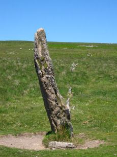
Harbourne Head Standing Stone
OS Map: SX 69676 65105
HER: MDV5197
Megalithic Portal: 42626
PMD: Harbourne Man Standing Stone
Alternate name: Harbourne Man Standing Stone
Short Name: SS Harbourne
Butler Vol 5: p.19
DPD: 88
Dimensions (m): 2.4 x 1.0 x 0.3
Notes: A standing stone represented by a leaning slab of moorland granite. It stands in a slight depression probably worn by cattle using it as a rubbing post. It is 2.40m in length and 1.0m by 0.3m at its base tapering to 0.3m by 0.15m. See also, Legendary Dartmoor: Dartmoor's Harbourne Man
Nearest Bus Stop: Buckfast Higher Mill Lane (4.7 km) [Route: 88]
Nearby sites: SX 69676 65105

Shapley Common Standing Stone
OS Map: SX 69992 82248
HER: No record
PMD: Shapley Common
Short Name: SS Shapley
Butler map: 23.5
Butler Vol 5: p.212
Notes: Possible standing stone, see Butler Vol V (1997) p 212.
Nearest Bus Stop (Minor): Warren House Inn (2.8 km) [Route: 171(20/07/26 to 19/09/26)]
Nearest Bus Stop (Major): Chagford The Square (5.3 km) [Route: 173,178,671]
Nearby sites: SX 69992 82248
Butterdon Hill (nr. Moretonhampstead) Standing Stone
Prehistoric Dartmoor Walks: Dartmoor Walk: Butterdon Hill (nr Moretonhampstead) Standing Stone
OS Map: SX 74784 88403
HER: MDV8278
Megalithic Portal: 33950
PMD: Butterdon Down Standing Stone
Alternate name: Butterdon Down Standing Stone
Short Name: SS Butter Down
Dimensions (m): 2.3
Notes: HER quoting J. V. S. Cocks Standing stone - prob. prehistoric. An upright stone, stands at the west edge of Butterdon Down, Moretonhampstead, beside the public footpath, 600 yards from Cranbrook Farm. It is between six and seven feet high and of slightly curved slab shape. Ref: Devon & Cornwall Notes & Queries 31 1970 pp. 225-26.
Nearest Bus Stop: Moretonhampstead Court Street Car Park (2.4 km) [Route: 173, 171(20/07/26 to 19/09/26)]
Nearby sites: SX 74784 88403
Maximajor Stone Standing Stone
Prehistoric Dartmoor Walks: Dartmoor Site: Mardon Down Stone Circle & Cairns
OS Map: SX 77076 87818
HER: MDV8281
Megalithic Portal: 22324
PMD: Headless Cross Standing Stone
Short Name: SS Maximajor
Dimensions (m): 1.6 (originally)
Notes: Situated on Mardon Moor, the Headless Cross, or Maximajor Stone, despite its name, was never a cross. It was a megalith although apparently the current stone is a replacement for the original which was damaged beyond repair by a car. See also: Legendary Dartmoor: The Maximajor Stone
Nearest Bus Stop: Moretonhampstead Court Street Car Park (2.6 km) [Route: 173, 171(20/07/26 to 19/09/26)]
Nearby sites: SX 77076 87818