
Guide to the Monuments on Merrivale
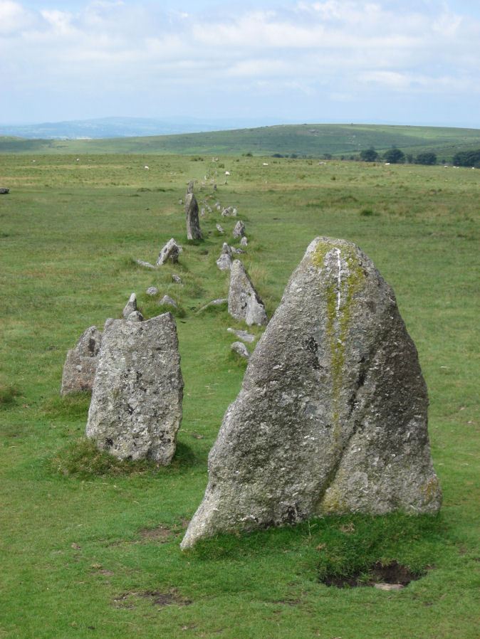
Table of Ritual and Burial Monuments on Merrivale
The following table lists the records currently in this Guide Map. For an explantion of the Guide Maps and a table of all 62 Guide Maps, follow this link: Guide List Table. Introductory text will be added to each guide list in 2025. Notes on duplication and omissions will appear below the table once checks have been finalised.
Notes on possible duplications and omissions
Merrivale omissions from the HER: There are four records above that do not have a matching HER entry. However, all of these features either represent either old records of features that can no longer be traced or otherwsie probably do not merit inclusion on the HER. Recommend no changes.PS. These notes are to assist untangling complicated records and are neither permanent nor a criticism of the HER who do a fantastic job! The author finds it easier to systematically work through these records (2000+ of them) and add these notes, which are then to be communicated with the HER, if appropriate, it is a pragmatic way of dealing with lots of data without continually stopping and starting.
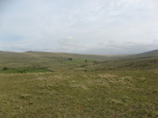
Merrivale Guide Map
Guidance for walkers: The monuments featured in this database are archaeological treasures and need to be protected and preserved - please do not disturb any sites. Please check access and firing times before visiting sites, not all sites listed are on open access land. Firing ranges and boundaries of open access areas are marked on the OL28 OS Dartmoor Explorer map. Please stick to the country code and consider giving support to the numerous agencies that help to keep Dartmoor a fabulous natural and historic environment!
List of Ritual and Burial Monuments on Merrivale
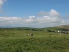
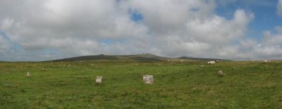
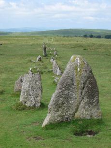
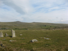
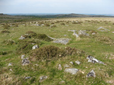
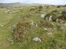
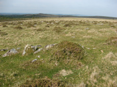
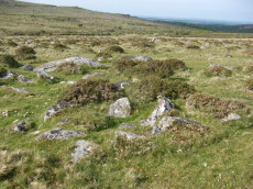
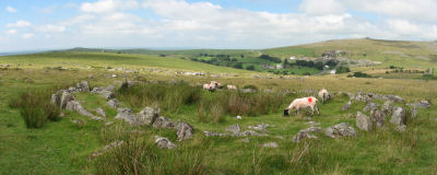
Merrivale Ceremonial Complex
OS Map: SX 55450 74790
HER record: MDV14795
Megalithic Portal: 2046
PMD: Merrivale
ShortName: CX Merrivale
DPD page: 16
Notes: The Merrivale Ceremonial Complex consists of a stone circle a large menhir and two double stone rows and burial cairns. See also: Legendary Dartmoor: Merrivale Ceremonial Complex. Lethbridge pp.16-18, diagram p.16.
Grinsell [Folklore 1976]: Formerly called the Potato Market or the Plague Market, perhaps from a time when goods were brought here for sale when the plague was raging in Tavistock. Bray 1879, letter ix; Crossing 1912/65, 94, note.
Nearby sites: SX55457479
Merrivale Stone Circle
OS Map: SX 55361 74641
HER record: MDV4998
Megalithic Portal: 116
PMD: Merrivale Stone Circle
ShortName: SC Merrivale
DPD page: 17
Turner: G14
Notes: "A stone circle with a diameter of 20.0m. measured from northeast to southwest and 18.0m from northwest to southeast. It is formed by eleven stones spaced between 2.7m and 6.7m. apart and from 0.3m. to 0.5m. high. Three of the stones are of post type and eight are upright slabs. An additional stone, 7.5m. from the northeast side and 0.3m high, is angled towards the circle and may be quite unassociated".
Nearby sites: SX55367464
Merrivale A Stone Row
OS Map: SX 55541 74809
HER record: MDV14797
Megalithic Portal: 2044
The Stone Rows of GB: Merrivale 1
PMD: Merrivale A Stone Row
Alternate name: Merrivale 1 Stone Row
ShortName: SR MerrivaleA
Butler map: 44.8.1
DPD page: 16
Notes: Worth Merrivale A. Butler Merrivale 1. "Two Bronze Age double stone rows and associated cairns are located on open moorland. The rows are oriented roughly east to west and are almost parallel, being 25 metres between centres at their eastern ends increasing to 32 metres at the west. A leat still used to convey water to Hillside Stables separates the two monuments and flows to within 2 metres of the northern row. A single row (see SX 57 SE 115) runs roughly south-west from a small cairn at SX 55397476, some 4.75 metres south of the south row." Lethbridge pp.16-18, diagram p.16.
Nearby sites: SX55547481
Merrivale B Stone Row
OS Map: SX 55567 74788
HER record: MDV14795
Megalithic Portal: 117
The Stone Rows of GB: Merrivale 2
PMD: Merrivale B Stone Row
Alternate name: Merrivale 2 Stone Row
ShortName: SR MerrivaleB
Butler map: 44.8.2
DPD page: 16
Notes: Butler Merrivale 2. Worth Merrivale B. For description see Merrivale A. Lethbridge pp.16-18, diagram p.16.
Nearby sites: SX55577479
Merrivale C Stone Row
OS Map: SX 55394 74761
HER record: MDV5001
Megalithic Portal: 3391
The Stone Rows of GB: Merrivale 3
PMD: Merrivale C Stone Row
Alternate name: Merrivale 3 Stone Row
ShortName: SR MerrivaleC
Butler map: 44.8.3
DPD page: 17
Notes: "A stone row and a small cairn lie to the south of the double stone rows in close-cropped moorland turf. The cairn located at the northern end and slightly off-centre to the row, measures 3.2m across and up to 0.5m high. An 0.3m deep central pit opens out on the southern side."
Nearby sites: SX55397476
Merrivale (Menhir 1) Stone Row
OS Map: SX 55361 74592
HER record: MDV53397
Megalithic Portal: 3388
The Stone Rows of GB: Merrivale 4
PMD: Merrivale Menhir I Stone Row
Alternate name: Merrivale 4 Stone Row
ShortName: SR Mer Menhir
Butler map: 44.8.4
DPD page: 17
Notes: Butler Row 4. Prehistoric Monuments of Dartmoor website Menhir 1. "Stone row 4 is now a trivial affair [Butler] of 3 small slabs aligned towards a squarish block near the base of the standing stone. This area has suffered some damage over the past century. There were 5 stones in 1895, the missing one presumably accounted for by the pit which has appeared between the upper stones. This may well be the site of the cairn, C4, at the head of the rows recorded by Rowe but not included in the plans of Lukis or Worth. Nor is there much surviving from the circle of slabs around the menhir depicted in Bray's plan and recorded by Spence Bate in 1871, or the nearby cist which he excavated, C5. The Exploration Committee excavated at both ends of the row but no more socket holes were found and they concluded that this short alignment was complete." Lethbridge pp.16-18, diagram p.16.
Nearby sites: SX55367459
Merrivale 5 Stone Row
OS Map: SX 55354 74592
HER record: MDV53398
The Stone Rows of GB: Merrivale 5
PMD: Merrivale Menhir II
ShortName: SR:Merrivale 5
Butler map: 44.8
Notes: HER: Possible stone alignment lying to the south-west of the standing stone at Merrivale. Stones are small and identification uncertain. Gerrard: Cluster of small earthfast upright granite slabs. This feature lies within 9.0 meters west of the standing stone (PRN 53395) and includes a number of stones protruding through the turf, the largest of which stands up to 0.35 meters high. The precise nature of the feature associated with these stones is uncertain because most of it survives as a buried feature, but they may represent the site of a second cairn identified in this area by Rowe or may represent part of a stone alignment. Butler: A small slab can be seen approximately 5.5m from the standing stone which seems to have been deliberately set and Butler makes reference to the 'tops of several more which can be seen in one or two lines' between that and the standing stone, although he does not plot these stones on his plan.
Nearby sites: SX55357459
Merrivale 6 Stone Row
OS Map: SX 55344 74590
HER: No record found
The Stone Rows of GB: Merrivale 6
ShortName: SR Merrivale 6
Butler map: 44.8
Notes: Gerrard: A probable single stone row measuring at least 6.4m long, including small-sized stones situated on a gentle south facing slope with extensive views towards Bodmin Moor. The row is orientated east to west and a restricted view of the sea may be of significance.
Nearby sites: SX55347459
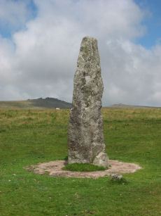
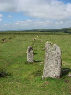
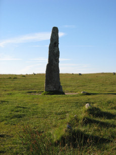
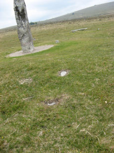
Merrivale Standing Stone
OS Map: SX 55359 74599
HER record: MDV53395
Megalithic Portal: 115
PMD: Merrivale Standing Stone
ShortName: SS Merrivale
Butler map: 44.8.4
DPD page: 17
Notes: "Two Bronze Age standing stones with a disturbed cairn and a number of small earth fast stones. Located in open generally clitter-free moorland. Only one of the two stones still stands; it is 3.2 metres high and tapers from the base which is 0.7 by 0.5 metres in section. Whether the stone was once the focus or terminus of a stone rows is uncertain. The second stone is now fallen, it is 2.2 metres long, up to 0.4 metres wide and 0.3 metres thick. An adjacent 0.3 metre deep pit may be its socket hole. "
Nearby sites: SX55367460
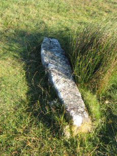
Merrivale Recumbent Slab Standing Stone
OS Map: SX 55371 74596
HER record: MDV53396
ShortName: SS-Merrivale 2
Butler map: 44.8.4
DPD page: 17
Notes: "The second stone is now fallen, it is 2.2 metres long, up to 0.4 metres wide and 0.3 metres thick. An adjacent 0.3 metre deep pit may be its socket hole." According to Butler it was "erected in 1895 in the pit alongside, toppling again a few years later". Breton (p.14) "A smaller menhir is near ..." [to the Merrivale Longstone].
Nearby sites: SX55377460
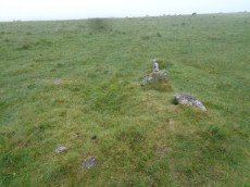
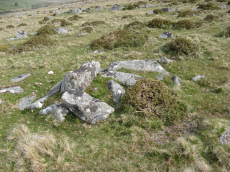
Merrivale NE Cairn Circle
OS Map: SX 55548 74817
HER record: MDV29078
Megalithic Portal: 3390
The Stone Rows of GB: Merrivale 1
PMD: Merrivale A Stone Row
Alternate name: Merrivale double row 1 (east end) Cairn Circle
ShortName: CC Merrivale 1
Butler map: 44.8.1
Notes: At the eastern end (of the northern stone row) there is a blocking stone and beyond it a number of earthfast and loose slabs which seem to represent a former kerb or circle about 5.6m. in diameter. The blocking stone is part of the circle with two or possibly three earthfast slabs on end, three recumbent slabs, and four other post or slab stones which are much displaced or entirely unconnected. The stones are spaced at about 2.0m. intervals; uprooted slabs are from 0.3m. square to 0.4m. by 0.5m., earthfast stones 0.1m. high. There is no sign of a cairn or cist.
Nearby sites: SX55557482
Merrivale double row B (centre) Encircled Cairn and Cist
OS Map: SX 55442 74779
HER record: MDV14796
Megalithic Portal: 3389
PMD: Merrivale S row
Alternate name: Merrivale double row 2 centre Encircled Cairn and Cist
ShortName: CT Merrivale 2
Butler map: 44.8.2
DPD page: 17
Grinsell: WAL 4
Turner: F20
Notes: Butler Merrivale double row 2, (centre) - Vol. 3. Map 44.8.1 (diagram p.27). Lethbridge pp.16-18, diagram p.16.
Nearby sites: SX55447478
Merrivale row 3 Cairn
OS Map: SX 55399 74770
HER record: MDV5000
PMD: Merrivale Short Stone Row
ShortName: CN Merrivale 3
Butler map: 44.8.3
Grinsell: WAL 2
Notes: Cairn located at the north-eastern end of the short single stone row, immediately south of the southern double stone row. It is of small stone construction, and is now turf-covered. "A small cairn that coontianed a ruined kistvaen" (Baring-Gould DEC Report No.2 1895)
Nearby sites: SX55407477
Merrivale row 4 Reported Cairn
OS Map: SX 55350 74580
HER: No record found
ShortName: CN?Merrivale 4
Butler map: 44.8.4
Notes: Cairn recored by Rowe at the head of Merrivale row 4. Not recorded by Lukis or worth. Not trabeable now.
Nearby sites: SX55357458
Spence Bate's Reported Cist
OS Map: SX 55300 74500
HER: No record found
Alternate name: Spence Bate's Reported Cist
ShortName: CN?Merrivale 5
Butler map: 44.8.5
Notes: Butler: "Nor is there much surviving from the circle of slabs around the menhir depicted in Bray's plan and recorded by Spence Bate in 1871, or the nearby cist which he excavated"
Nearby sites: SX55307450
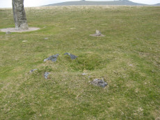
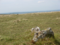
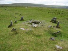
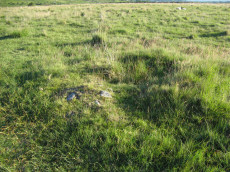
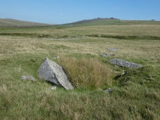
Merivale (S) Encircled Cairn
OS Map: SX 55368 74602
HER record: MDV3759
Megalithic Portal: 52014
The Stone Rows of GB: Merrivale 4
PMD: Merrivale Menhir
Alternate name: Merrivale 6 (near standing stone) Encircled Cairn
ShortName: EC Merrivale 6
Butler map: 44.8.6
Grinsell: WAL 6
Turner: F19
Notes: The cairn now turf-covered with an excavation pit in the centre, has a diameter of 2.4m. and a height of 0.1m. The excavation pit can be seen in the photo. A very irregular "circle" of stones can be seen around this cairn. Turner F19.
Nearby sites: SX55377460
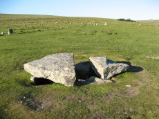
Merrivale Cist
OS Map: SX 55490 74770
HER record: MDV3738
Megalithic Portal: 10465
PMD: Merrivale
Alternate name: Merrivale 7 Cist
ShortName: CT Merrivale 7
Butler map: 44.8.7
DPD page: 18
Grinsell: WAL 5
Notes: HER: A very fine Bronze Age cist which measures internally 2.2 metres long by 0.9 metres wide and up to 0.8 metres deep. The triangular-shaped slab which forms the massive cover stone is up to 2.1metres wide and averages 0.4 metres thick; a central part has been removed by stone cutters revealing the water-filled cist and a broken fragment of the coverslab.
Nearby sites: SX55497477
Merrivale Embanked Cairn Circle and Cist
OS Map: SX 55360 74747
HER record: MDV4997
Megalithic Portal: 10503
PMD: Merrivale SW.
Alternate name: Merrivale 8 Embanked Cairn Circle and Cist
ShortName: CT Merrivale 8
Butler map: 44.8.8
Grinsell: WAL 1
Turner: B2
Notes: "The excavation of 1851 seems to have been thorough, completely destroying structural remains of both the cairn and the 'cist or inner circle',. There is now a circular turf covered area, 18.0m. in diameter, with random stones protruding through the surface. Off centre there is a hollow, 7.0m. by 4.0m. and 0.5m. deep." Butler Merrivale Vol. 3. Map 44.8.8 (pp.30-1).
Nearby sites: SX55367475
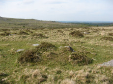
Merrivale 9 Cairn
OS Map: SX 55353 74725
HER record: MDV28496
ShortName: CN Merrivale 9
Butler map: 44.8.9
Grinsell: WAL 3
Notes: "Cairn measuring 4.0 meters in diameter and standing 0.6 meters high, with a pit 1.3 meters in diameter by 0.4 meters deep in the centre of the mound."
Nearby sites: SX55357473
Merrivale North Embanked Cairn Circle
OS Map: SX 55340 74845
HER record: MDV3757
Megalithic Portal: 10502
Alternate name: Merrivale 10 Embanked Cairn Circle
ShortName: CC Merrivale10
Butler map: 44.8.10
Turner: B8
Notes: "Turner describes this site as an embanked stone circle; an annular bank of earth and/or stones with an inner edge of orthostats. Internal diameter is 8.0 meters with a bank 0.8 meters wide and 0.3 meters high. Much disturbed." Turner B8.
Nearby sites: SX55347485
Merrivale 11 Reported Cairn
OS Map: SX 55800 74940
HER: No record found
ShortName: CN:Merrivale11
Butler map: 44.8.11
Notes: Butler: "A total casualty, C11, is the cairn on the north side of the road shown in the plan accompanying the Exploration Committee's report. It was apparently large about the size of C8, but had completely disappeared by 1895"
Nearby sites: SX55807494
Merrivale 12 Cairn
OS Map: SX 55640 74870
HER record: MDV28493
ShortName: CN Merrivale12
Butler map: 44.8.12
Notes: HER: The remains of a stony cairn are visible in an area of clitter and close-cropped moorland turf on the fringe of a large Bronze Age settlement. The loosely piled stones and boulders measure 6.7 metres by 3.8 metres and form two piles each 0.5 metres high. There is no evidence to suggest the presence of an original kerb. It is probably a Post Medieval stone clearance heap rather than a Bronze Age cairn.
Nearby sites: SX55647487
Merrivale reave 13 Reported Cairn
OS Map: SX 55605 74758
HER record: MDV4961
ShortName: CN-Merrivale13
Butler map: 44.8.13
Notes: Their form and positioning does not suggest either a prehistoric origin nor a sepulchral use. [N.B. This Butler entry Merrivale reave cairns 13 (1-5) has been separated into individual sites.]
Nearby sites: SX55617476
Merrivale reave 14 Reported Cairn
OS Map: SX 55633 74716
HER record: MDV28497
ShortName: CN-Merrivale14
Butler map: 44.8.14
Nearby sites: SX55637472
Merrivale reave 15 Reported Cairn
OS Map: SX 55641 74697
HER record: MDV53412
ShortName: CN-Merrivale15
Butler map: 44.8.15
Nearby sites: SX55647470
Merrivale reave 16 Reported Cairn
OS Map: SX 55647 74689
HER record: MDV53413
ShortName: CN-Merrivale16
Butler map: 44.8.16
Nearby sites: SX55657469
Merrivale reave 17 Reported Cairn
OS Map: SX 55661 74675
HER record: MDV28492
ShortName: CN-Merrivale17
Butler map: 44.8.17
Nearby sites: SX55667468
Merrivale 18 Cairn
OS Map: SX 55280 74742
HER record: MDV103582
ShortName: CN Merrivale18
Nearby sites: SX55287474
Merrivale 19 Cairn
OS Map: SX 55294 74727
HER record: MDV103583
ShortName: CN Merrivale19
Nearby sites: SX55297473
Merrivale Bridge E. Reported Cairn
OS Map: SX 55700 75200
HER record: MDV61740
ShortName: CN:Merrivale20
Nearby sites: SX55707520
Merrivale Bridge E.2 Reported Cairn
OS Map: SX 55964 75448
HER record: MDV56739
ShortName: CN-Merrivale21
Notes: Dubious. Visited 09/09/23. There are nearby mounds with lots of activity of stone cutters. The appearance of this site is modern and the HER suggests " military training pit". Either way, it is not prehistoric. Entry altered to reflect it is not a cairn.
Nearby sites: SX55967545
Merrivale Bridge N. Reported Cairn
OS Map: SX 55256 75145
HER record: MDV28518
ShortName: CN Merrivale22
Butler map: 30.7
Notes: Cairn or hut? "Recorded by Ordnance Survey (1979) as a hut, but Gerrard (1999) suggests it is a cairn. Feature measures 5.7 metres in diameter, height 0.6 metres. Kerb visible in places. Large numbers of rocks with quartz in them. Cairn lies 6 metres from field wall, which appears to kink around it." Visited 09/09/23 - a bit of a jumble of stones covered in vegetation. Identification of correct site not 100% certain but fits with mutilated cairn.
Nearby sites: SX55267515
Merrivale 23 Reported Cairn
OS Map: SX 55000 75000
HER record: MDV4198
ShortName: CN?Merrivale23
Nearby sites: SX55007500
Merrivale (claimed cist) Reported Cist
OS Map: SX 55570 74700
HER record: MDV131639
PMD: Wood & Pennys Cist at Merrivale
ShortName: CNxMerrivale24
Grinsell: WAL 6a
Notes: Wood and Penny assert that a cairn containing a cist lies at SX55577470, at end of stone row. Grinsell suggests this is a natural feature. Alleged Bronze Age cairn and cist, but apparently a feature caused by a random spread of naturally occuring stones and boulders
Nearby sites: SX55577470
Merrivale Newtake Cist
OS Map: SX 55518 75832
HER record: MDV102721
PMD: Merrivale Newtake
ShortName: CT Merrivale25
Notes: Greeves 2006 Very probable prehistoric cist set in a small cairn, with a discrete set slab on east side of cairn mound. The author visited 09/09/23 and while no cist stones were visible (could be covered) the site does look like a possible cist.
Nearby sites: SX55527583
Merrivale Settlement
OS Map: SX 55500 74900
HER record: MDV4897
Megalithic Portal: 1520
ShortName: ST Merrivale
DPD page: 18
Notes: Merrivale Prehistoric Settlement is a partially enclosed stone hut circle settlement, including at least thirty six hut circles and four separate enclosures. Lethbridge pp.16-18, diagram p.16.
Nearby sites: SX55507490
Yellowmeade Farm Cist
OS Map: SX 56350 74465
HER record: MDV5002
Megalithic Portal: 45778
PMD: Yellowmeade Farm NW.
Alternate name: Yellowmeade 1 Cist
ShortName: CT Yellowm Fm1
Butler map: 44.1.1
DPD page: 18
Grinsell: WAL 7
Barrow Report: 67
Notes: Butler Yellowmeade 1 - Vol. 3. Map 44.1 (diagram p.17).
Nearby sites: SX56357447

Yellowmeade 2 Reported Cist
OS Map: SX 56460 74413
HER record: MDV28491
ShortName: CN Yellowm Fm2
Butler map: 44.1.2
Notes: HER: a cairn, of possibly prehistoric date measuring 3.3m across x 0.3m high, with no definite kerb but one recumbent slab stone on the east side. It is near a ruined hut circle and a newtake wall may indicate a collection heap for wall construction. Butler: Yellowmeade Cairn '2' at SX56467442 of 3.0 metres by 4.5 metres by 0.3 metres high. Oval mound lying a few metres from Hut Circle '9' which was obviously the source of its stones. Gerrard: Round cairn 4m by 3.5m by 0.5m high. Cist. Large number of large stones protruding. Several stones are edge set. Low grass cover.
Barrow Report 67 and Gerrard suggest this could be a cist.
Nearby sites: SX56467441

Mis Tor Farm Embanked Cairn Circle
OS Map: SX 56927 75953
HER record: MDV15372
Megalithic Portal: 45609
Alternate name: Little Mis Tor S.E. Embanked Cairn Circle
ShortName: CC MisTor Farm
Butler map: 30.17
Butler Vol 5: p.163 & Fig.104
Grinsell: LYD 37a
Turner: B13
Notes: HER Base of ancient tumulus, about 20m in diameter, may have formed a bound of the ancient boundary between Lydford and Walkhampton (Prowse). Butler: Little Mis Tor SE cairn at SX56927595 of 22.0 metres diameter by 0.4 metres high. This large but low cairn has suffered some trenching around the eastern side. An outer bank 22 metres across surrounds a level interior rising to a small mound at the centre on which are lying several small stones. The few slabs visible within the bank show that it was built with inner and outer faces around a rubble core.
Nearby sites: SX56937595
Page last updated 10/12/24