
Merrivale Cist
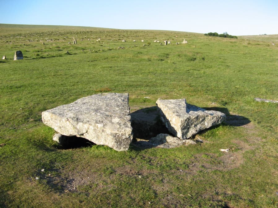
Photo taken on 26-06-2018
Database entries
PDW coverage: Dartmoor Walk: Merrivale Complex
OS Map: SX 55490 74770
OS Source: Garmin
Butler OS: SX55477476
HER: MDV3738
Megalithic Portal: 10465
PMD: Merrivale
Alternate name: Merrivale 7
Short Name: CT Merrivale 7
Butler map: 44.8.7
Dixon Cist #: 98
Grinsell: WALKHAMPTON 5
DPD page: 18
Exist: Yes
Record: Unique
Record Source: Butler
Hut Class: No
Cist Class: Yes
Cairn Class: Yes
Dimensions (m): 2.2 x 0.9 C
Lidar: SX 55490 74770
Guide Map: 33
Nearest Bus Stop: Merrivale Dartmoor Inn (0.9 km) [Route: 98,171(20/07/26 to 19/09/26)]
Nearby sites: SX 55490 74770
Notes
HER: A very fine Bronze Age cist which measures internally 2.2 metres long by 0.9 metres wide and up to 0.8 metres deep. The triangular-shaped slab which forms the massive cover stone is up to 2.1metres wide and averages 0.4 metres thick; a central part has been removed by stone cutters revealing the water-filled cist and a broken fragment of the coverslab.Breton (p.14): The capstone was mutilated by a farmer in 1860, who cut a gate post out of the middle of it.
See also, Legendary Dartmoor: The Merrivale Kist. Lethbridge pp.16-18, diagram p.16. Butler Vol. 3. Map 44.8.7 (diagram of location in ceremonial complex p.24, diagram of cist p.31).
References
These are selected references with an emphasis on out of copyright sources linked as PDFs. For more detailed references try any linked HER or PMD record above.
- Baring-Gould, Sabine, Second Report of the Dartmoor Exploration Committee, T.D.A. Vol.27 pp.81-92 (1895)
- Bate, C Spence, On the Prehistoric Antiquities of Dartmoor, T.D.A. Vol.4 pp.491-516 (1871)
- Brailsford, J. W, Bronze Age Stone Monuments of Dartmoor, Antiquity Volume 12, Number 48 pp.444-63 (1938)
- Bray, Anna Eliza, The Borders of the Tamar and the Tavy, vol.1, (1836)
- Breton, Henry Hugh, The Heart of Dartmoor, (1926)
- Butler, Jeremy, Dartmoor Atlas of Antiquities, vol.3: The South-West, (1994)
- Grinsell, L.V., Dartmoor Barrows, Devon Archaeological Society Proceedings No.36 (1978)
- Kempe, Account of some Monuments conjectured to be British, still existing upon Dartmoor, Archaeologia 22 pp.429-35 (1829)
- Lethbridge, William D., Discover Preshistoric Dartmoor, (2015)
- Page, John Lloyd Warden, An Exploration of Dartmoor and its Antiquities, with some account of its borders, (1889)
- Rowe, Samuel, A Perambulation of Dartmoor (3rd Edition), (1896)
- Worth, R. Hansford, Barrow Report 21, T.D.A. Vol.34 pp.104- 146 (1902)