
Merrivale NE Cairn Circle
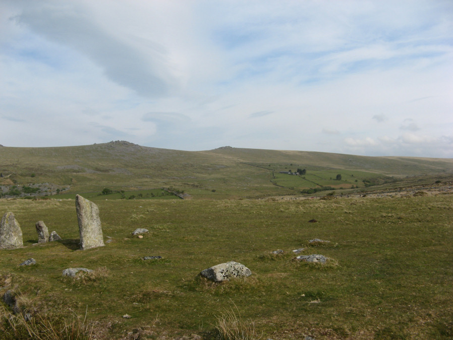
Photo taken on 17-05-2019
Database entries
PDW coverage: Dartmoor Site: Merrivale Ceremonial Complex [Photo Set 1]
OS Map: SX 55548 74817
OS Source: Google
Butler OS: SX55557482
HER: MDV29078
Megalithic Portal: 3390
The Stone Rows of GB: Merrivale 1
PMD: Merrivale A Stone Row
Alternate name: Merrivale double row 1 (east end)
Short Name: CC Merrivale 1
Butler map: 44.8.1
Exist: Yes
Record: Unique
Record Source: Butler
Hut Class: No
Cairn Class: Yes
Dimensions (m): c.5.0
Lidar: SX 55548 74817
Guide Map: 33
Nearest Bus Stop: Merrivale Dartmoor Inn (1.0 km) [Route: 98,171(20/07/26 to 19/09/26)]
Nearby sites: SX 55548 74817
Notes
At the eastern end (of the northern stone row) there is a blocking stone and beyond it a number of earthfast and loose slabs which seem to represent a former kerb or circle about 5.6m. in diameter. The blocking stone is part of the circle with two or possibly three earthfast slabs on end, three recumbent slabs, and four other post or slab stones which are much displaced or entirely unconnected. The stones are spaced at about 2.0m. intervals; uprooted slabs are from 0.3m. square to 0.4m. by 0.5m., earthfast stones 0.1m. high. There is no sign of a cairn or cist.References
These are selected references with an emphasis on out of copyright sources linked as PDFs. For more detailed references try any linked HER or PMD record above.
- Bate, C Spence, On the Prehistoric Antiquities of Dartmoor, T.D.A. Vol.4 pp.491-516 (1871)
- Brailsford, J. W, Bronze Age Stone Monuments of Dartmoor, Antiquity Volume 12, Number 48 pp.444-63 (1938)
- Bray, Anna Eliza, The Borders of the Tamar and the Tavy, vol.1, (1836)
- Brent, Francis, Prehistoric Remains on Dartmoor, Journal of the British Archaeological Association Vol.39 pp.217-222 (1883)
- Butler, Jeremy, Dartmoor Atlas of Antiquities, vol.3: The South-West, (1994)
- Emmett, D.D., Stone rows: the traditional view reconsidered, D.A.S.P. No.37 pp.94-114 (1979)
- Fergusson, James, Rude stone monuments, (1872)
- Rowe, Samuel, A Perambulation of Dartmoor (3rd Edition), (1896)
- Wilkinson J. Gardner, The Rock-basins of Dartmoor, and some British Remains in England, Journal Brit. Arch. Assoc. xvi. pp.101-132. (1860)
- Worth, R. Hansford, Retaining circles associated with stone rows Dartmoor, T.D.A. Vol.73 pp.227-38 (1941)
- Worth, R. Hansford, The Stone Rows of Dartmoor Part 1, T.D.A. Vol.78 pp.285-316 (1946)
- Worth, R.N., The Stone Rows of Dartmoor - Part 1, T.D.A. Vol.24 pp.387-417 (1892)
- Worth, R.N., The Stone Rows of Dartmoor - Part 4, T.D.A. Vol.27 pp.437-442 (1895)