
Merrivale A Stone Row
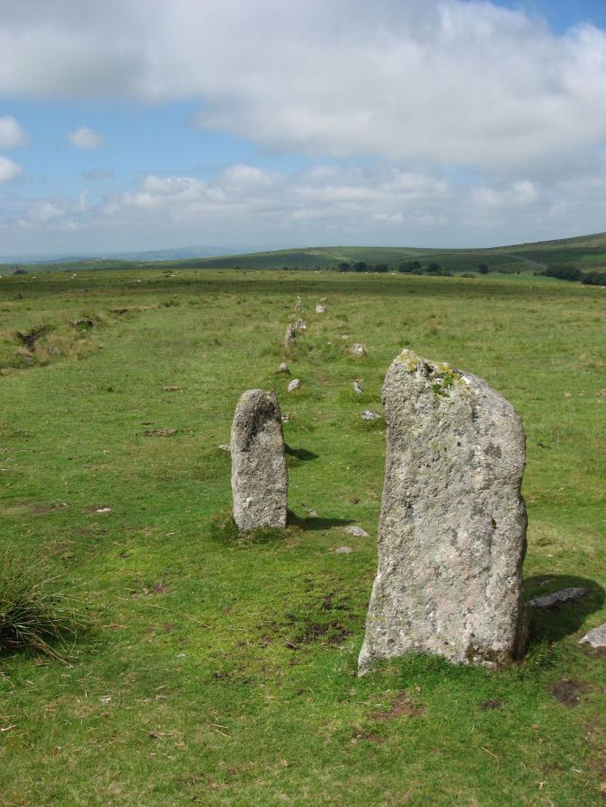
Photo taken on 25-07-2010
Database entries
PDW coverage: Dartmoor Site: Merrivale Ceremonial Complex [Photo Set 1]
OS Map: SX 55541 74809
OS Source: SRGB
HER: MDV14797
Megalithic Portal: 2044
The Stone Rows of GB: Merrivale 1
PMD: Merrivale A Stone Row
Alternate name: Merrivale 1
Short Name: SR MerrivaleA
Butler map: 44.8.1
DPD page: 16
Exist: Yes
Record: Unique
Record Source: PDW
Hut Class: No
Dimensions (m): 183
Lidar: SX 55541 74809
Guide Map: 33
Nearest Bus Stop: Merrivale Dartmoor Inn (1.0 km) [Route: 98,171(20/07/26 to 19/09/26)]
Nearby sites: SX 55541 74809
Notes
Worth Merrivale A. Butler Merrivale 1. "Two Bronze Age double stone rows and associated cairns are located on open moorland. The rows are oriented roughly east to west and are almost parallel, being 25 metres between centres at their eastern ends increasing to 32 metres at the west. A leat still used to convey water to Hillside Stables separates the two monuments and flows to within 2 metres of the northern row. A single row (see SX 57 SE 115) runs roughly south-west from a small cairn at SX 55397476, some 4.75 metres south of the south row." Lethbridge pp.16-18, diagram p.16.References
These are selected references with an emphasis on out of copyright sources linked as PDFs. For more detailed references try any linked HER or PMD record above.
- A-Z, Dartmoor Sketches, (1870)
- Baring-Gould, Sabine, A Book of Dartmoor, (2002)
- Bate, C Spence, On the Prehistoric Antiquities of Dartmoor, T.D.A. Vol.4 pp.491-516 (1871)
- Brailsford, J. W, Bronze Age Stone Monuments of Dartmoor, Antiquity Volume 12, Number 48 pp.444-63 (1938)
- Bray, Anna Eliza, The Borders of the Tamar and the Tavy, vol.1, (1836)
- Brent, Francis, Prehistoric Remains on Dartmoor, Journal of the British Archaeological Association Vol.39 pp.217-222 (1883)
- Breton, Henry Hugh, The Heart of Dartmoor, (1926)
- Burnard, Robert, Dartmoor Pictorial Records, (1986)
- Butler, Jeremy, Dartmoor Atlas of Antiquities, vol.3: The South-West, (1994)
- Chudleigh, J, Devonshire Antiquities, (1893)
- Emmett, D.D., Stone rows: the traditional view reconsidered, D.A.S.P. No.37 pp.94-114 (1979)
- Evans, Rachel, Home Scenes, Or, Tavistock and Its Vicinity, (1846)
- Fergusson, James, Rude stone monuments, (1872)
- Kempe, Account of some Monuments conjectured to be British, still existing upon Dartmoor, Archaeologia 22 pp.429-35 (1829)
- Lethbridge, William D., Discover Preshistoric Dartmoor, (2015)
- Lukis, W.C, Report on the Monuments of Dartmoor, Proceeding of the Society of Antiquaries Vol.8 (1881)
- Page, John Lloyd Warden, An Exploration of Dartmoor and its Antiquities, with some account of its borders, (1889)
- Rowe, Samuel, A Perambulation of Dartmoor (3rd Edition), (1896)
- Thom, A and Burl, A, Stone Rows and Standing Stones, (1990)
- Wilkinson J. Gardner, The Rock-basins of Dartmoor, and some British Remains in England, Journal Brit. Arch. Assoc. xvi. pp.101-132. (1860)
- Worth, R. Hansford, Retaining circles associated with stone rows Dartmoor, T.D.A. Vol.73 pp.227-38 (1941)
- Worth, R. Hansford, The Stone Rows of Dartmoor Part 1, T.D.A. Vol.78 pp.285-316 (1946)
- Worth, R.N., The Stone Rows of Dartmoor - Part 1, T.D.A. Vol.24 pp.387-417 (1892)
- Worth, R.N., The Stone Rows of Dartmoor - Part 2, T.D.A. Vol.25 pp.541-546 (1893)
- Worth, R.N., The Stone Rows of Dartmoor - Part 4, T.D.A. Vol.27 pp.437-442 (1895)