
Prehistoric sites within 3km of SX 58500 89900
Guidance for walkers: The monuments featured in this database are archaeological treasures and need to be protected and preserved - please do not disturb any sites. Please check access and firing times before visiting sites, not all sites listed are on open access land. Firing ranges and boundaries of open access areas are marked on the OL28 OS Dartmoor Explorer map. Please stick to the country code and consider giving support to the numerous agencies that help to keep Dartmoor a fabulous natural and historic environment!
About the database listings: In all listings clicking on the photo or the site name will open a page for the site with a larger photo and further details from the database. The database now has over 6680 records covering nearly all publicly listed sites on Dartmoor including around 4800 round houses. This level of detail is of interest to archaeologists but tends to swamp listings of sites more likely to be of interest for walkers. For this reason, the listings default to around 550 core sites only. These are the stone circles, stone rows and the ring cairns listed by Turner. The default search radius is 2 km. The controls below the map can be used to start a new search by entering a 6- or 8-digit reference (without the prefix "SX"). The search radius can be specified and you can add incremental Display layers of detail on top of the core sites. If using a more detailed layer you will need to decrease the search radius to avoid getting hundreds of search results.
- Core sites Default listing of core sites consisting of stone circles & rows and some of the major ring cairns.
- Plus cairns adds approx. 1000 cairns and other minor sites not included in the core listings but excluding round houses.
- Plus round houses adds approx. 4800 round houses.
- Plus non-sites adds in the records for sites that no longer exist or are not prehistoric sites.
- Plus duplicates adds records excluded as duplicates. Those maybe duplicate records in external listings (e.g. the Historic Environment Records). For example, some sites have been identified as cairns in some listings and interpreted as round houses in other listings and both records appear.
These listings have incorporated, matched up and merged all of the records from all of the major archaeological listings including: Worth, Grinsell, Turner, Butler, Bill Radcliffe, Sandy Gerrard, Megalithic Portal, the National Monument Records and the Historic Environment Records. The author would like to thank Bill, Sandy, the lovely people both at Megalithic Portal (especially Anne Tate who did an amazing job to link listings) and at ACE Archaeology for collaborative work over the years to synchronise and correct listings across the various websites which now interlink. A culmination of years of work the final merger of cairn records took 3 months of cross referencing in 2017 the result being a snapshot of the records at that time. This data has in turn been refined since by field work and research. The round house data was supplied by Sandy Gerrard. Grid references are in order of accuracy: from Google Earth satellite, if visible and found, from a Garmin GPS reading, if visited by the author and from the literature otherwise. Individual site pages will state the source of the grid reference and provide satellite imagery. If a site listing lacks a photo it has not yet been visited by the author in which case the grid reference is from the literature.
Currently the database only includes sites which can be represented by a grid reference. Reaves are not included as they require GIS shape technology which is beyond the current capability of this system. To see the sources for the records, look at the tables on the resources menu. The database listings can also be viewed on a Google map and downloaded as GPS datasets for Garmin devices.
Corrections, or any feedback or suggestions are very welcome, email: info@dartmoorwalks.org.uk.
NOTE: Clicking on the icons for each monument in the map will give the name of the site. You can zoom in and out and drag the map around.
List of sites within 3km of SX 58500 89900
Black-a-ven Brook Round House
OS Map: SX 597 908
HER: MDV69491
ShortName: HT:Black-a-v1
Nearby sites: SX 597 908
Distance: 1.50km
East Bowden Round House
OS Map: SX 5981 9240
HER: MDV60256
ShortName: HT:East Bowd2
Nearby sites: SX 5981 9240
Distance: 2.82km
Homerton Hill Round House
OS Map: SX 5662 9032
HER: MDV52490
ShortName: HT:Homerton 1
Nearby sites: SX 5662 9032
Distance: 1.93km
Kitty Tor E Round House
OS Map: SX 57595 87345
HER: MDV60360
ShortName: HT:Kitty Tor1
Nearby sites: SX 57595 87345
Distance: 2.71km
Kitty Tor E Round House
OS Map: SX 57567 87374
HER: MDV103661
ShortName: HT:Kitty Tor2
Nearby sites: SX 57567 87374
Distance: 2.69km
Kitty Tor E Round House
OS Map: SX 57572 87414
HER: MDV103661
ShortName: HT:Kitty Tor3
Nearby sites: SX 57572 87414
Distance: 2.65km
Kitty Tor E Round House
OS Map: SX 57588 87324
HER: MDV60360
ShortName: HT:Kitty Tor4
Nearby sites: SX 57588 87324
Distance: 2.73km
Lints Tor NW Round House
OS Map: SX 57775 87725
HER: MDV5557
ShortName: HT:Lints Tor1
Nearby sites: SX 57775 87725
Distance: 2.29km
Lints Tor NW Round House
OS Map: SX 57765 87755
HER: MDV5557
ShortName: HT:Lints Tor2
Nearby sites: SX 57765 87755
Distance: 2.27km
Lints Tor NW Round House
OS Map: SX 57765 87785
HER: MDV5557
ShortName: HT:Lints Tor3
Nearby sites: SX 57765 87785
Distance: 2.24km
Lints Tor NW Round House
OS Map: SX 57775 87705
HER: MDV5557
ShortName: HT:Lints Tor4
Nearby sites: SX 57775 87705
Distance: 2.31km
Lints Tor NW Round House
OS Map: SX 57835 87735
HER: MDV5557
ShortName: HT:Lints Tor5
Nearby sites: SX 57835 87735
Distance: 2.26km
Lints Tor NW Round House
OS Map: SX 57845 87675
HER: MDV5557
ShortName: HT:Lints Tor6
Nearby sites: SX 57845 87675
Distance: 2.32km
Lints Tor NW Round House
OS Map: SX 57855 87705
HER: MDV5557
ShortName: HT:Lints Tor7
Nearby sites: SX 57855 87705
Distance: 2.29km
Lints Tor NW Round House
OS Map: SX 57805 87675
HER: MDV5557
ShortName: HT:Lints Tor8
Nearby sites: SX 57805 87675
Distance: 2.33km
Lints Tor NW Round House
OS Map: SX 57785 87695
HER: MDV5557
ShortName: HT:Lints Tor9
Nearby sites: SX 57785 87695
Distance: 2.32km
Lints Tor NW Round House
OS Map: SX 57705 87725
HER: MDV5557
ShortName: HT:Lints Tor10
Nearby sites: SX 57705 87725
Distance: 2.32km
Lints Tor NW Round House
OS Map: SX 57755 87735
HER: MDV5557
ShortName: HT:Lints Tor11
Nearby sites: SX 57755 87735
Distance: 2.29km
Lints Tor NW Round House
OS Map: SX 57725 87725
HER: MDV5557
ShortName: HT:Lints Tor12
Nearby sites: SX 57725 87725
Distance: 2.31km
Lints Tor NW Round House
OS Map: SX 57725 87705
HER: MDV5557
ShortName: HT:Lints Tor13
Nearby sites: SX 57725 87705
Distance: 2.33km
Lints Tor NW Round House
OS Map: SX 57715 87705
HER: MDV5557
ShortName: HT:Lints Tor14
Nearby sites: SX 57715 87705
Distance: 2.33km
Lints Tor NW Round House
OS Map: SX 57705 87755
HER: MDV5557
ShortName: HT:Lints Tor15
Nearby sites: SX 57705 87755
Distance: 2.29km
Lints Tor NW Round House
OS Map: SX 57705 87735
HER: MDV5557
ShortName: HT:Lints Tor16
Nearby sites: SX 57705 87735
Distance: 2.31km
Lints Tor NW Round House
OS Map: SX 57715 87735
HER: MDV5557
ShortName: HT:Lints Tor17
Nearby sites: SX 57715 87735
Distance: 2.30km
Lints Tor SW Round House
OS Map: SX 57845 87235
HER: MDV11805
ShortName: HT:Lints Tor18
Nearby sites: SX 57845 87235
Distance: 2.74km
Lints Tor SW Round House
OS Map: SX 57805 87225
HER: MDV11805
ShortName: HT:Lints Tor19
Nearby sites: SX 57805 87225
Distance: 2.76km
Oke Tor Round House
OS Map: SX 6144 8984
HER: MDV60303
ShortName: HT:Oke Tor1
Nearby sites: SX 6144 8984
Distance: 2.94km
Oke Tor Round House
OS Map: SX 6145 8981
HER: MDV60304
ShortName: HT:Oke Tor2
Nearby sites: SX 6145 8981
Distance: 2.95km
Oke Tor Round House
OS Map: SX 6140 8997
HER: MDV60299
ShortName: HT:Oke Tor3
Nearby sites: SX 6140 8997
Distance: 2.90km
Oke Tor Round House
OS Map: SX 6138 8996
HER: MDV60299
ShortName: HT:Oke Tor4
Nearby sites: SX 6138 8996
Distance: 2.88km
West Mill Tor Round House
OS Map: SX 5887 9073
HER: MDV11813
ShortName: HT:West Mill1
Nearby sites: SX 5887 9073
Distance: 0.91km
Winter Tor Round House
OS Map: SX 6090 9136
HER: MDV27405
ShortName: HT:Winter To1
Nearby sites: SX 6090 9136
Distance: 2.81km
Halstock Down 8 Stone Ring Cairn Circle
OS Map: SX 5957 9212
HER: MDV58788
ShortName: RC:Halstock 8
Notes: HER: is=28/3/1998 (greeves) prehistoric ring cairn immediately on w side of rough track about 90m n of point where track joins tarmac road. External diam is c.22m-25m. The ring bank is c.4m wide where best preserved (on nw side) by c.0.4m high (max).
Nearby sites: SX 5957 9212
Distance: 2.46km
Halstock Down 3 Stone Ring Cairn Circle
OS Map: SX 5976 9218
HER: MDV60254
ShortName: RC:Halstock 3
Notes: HER: A severely damaged cairn lies on the south west flank of Halstock Down 65 metres above the military ring road. All that remains is a stony fringe 1.2 to 1.6 metres wide and 0.4 metres high indicating an original diameter of around 20 metres for this feature. The interior of the cairn has been removed down to the old ground surface which has been further disturbed by later pits.
Also In the southern field is a circular bank measuring up to 3m wide and 0.6m high surrounding a 17.5m diameter internal area. The ring bank has been cut in four places by military pits and others in the vicinity further confuse the situation. Despite this, it is clear that this earthwork represents the site of a ring cairn.
Nearby sites: SX 5976 9218
Distance: 2.60km
Halstock Down 4 Stone Ring Cairn Circle
OS Map: SX 597 923
HER: MDV22786
ShortName: RC:Halstock 4
Notes: HER: Vis=10/9/1979 (os) a circular bank of small stones 4.8m diameter, 1.5m wide and 0.2m high with a 4.0m break in the nw. Situated on high ground in an area which appears to have been cleared at some time and put to pasture. The position seems too exposed for a hut yet there is virtually no stone in the central space. Possibly a robbed cairn. A second cropmark 20.0m to the sw is a depression caused by military activity (os).
Nearby sites: SX 597 923
Distance: 2.68km
Homerton Hill 3 Cairn Circle
OS Map: SX 5622 9037
HER: MDV52472
ShortName: CN:Homerton 3
Notes: HER: Possible ring cairn of 9.5 metres diameter lies on the crest of Homerton Hill. The enclosing bank on the south side is 2.4 metres wide by 0.4 metres high. This feature has been incorporated into a later field system, also associated with a hut circle and several clusters of clearance cairns some of which have been Scheduled.
Nearby sites: SX 5622 9037
Distance: 2.33km
Black Down Cairn
OS Map: SX 58463 92328
HER: MDV61330
ShortName: CN BlackDown 1
Butler map: 42.5
Notes: "The monument includes a round cairn situated on Black Down on a narrow shelf on a steep east facing slope overlooking the valley of the Moor Brook. The cairn measures 8m in diameter and stands up to 0.8m high. A hollow in the centre of the mound represents the site of an early investigation. A further narrow trench cut next to the north western side of the mound is probably the result of historic military interference."
Nearby sites: SX 58463 92328
Distance: 2.43km
Longstone Hill S. Cairn
OS Map: SX 56909 90553
HER: MDV52507
ShortName: CN:Longstone S
Butler map: 42.9
Notes: HER: A very disturbed cairn on Longstone Hill. The mound measures 8.7 metres north-south by 8.3 metres and stands a maximum of 1.0 metres high on its west side. The western half of the interior is occupied by two amorphous hollows, which appear to be unrecorded antiquarian excavations. Spoil from these features has been deposited on the southern flank of the cairn. There is no evidence to suggest the presence of a kerb or cist.
Nearby sites: SX 56909 90553
Distance: 1.72km
Homerton Hill S. Cairn
OS Map: SX 56409 90182
HER: MDV103577
ShortName: CN Homerton S
Butler map: 43.15
Notes: HER: Cairn 300 metres to the south of the cairnfield on Homerton Hill. The turf covered mound measures 15 metres in diameter by up to 0.6 metres high
Nearby sites: SX 56409 90182
Distance: 2.11km
Halstock Down 1 Cairn
OS Map: SX 5974 9223
HER: MDV60252
ShortName: CN:Halstock 1
Notes: HER : SX 5974 9223 three cairns forming part of a cairnfield and irregular aggregate field system 800m s of moorgate farm.
Nearby sites: SX 5974 9223
Distance: 2.64km
Halstock Down 2 Cairn
OS Map: SX 5974 9214
HER: MDV60253
ShortName: CN:Halstock 2
Notes: HER: SX 5974 9214 A cairn forming part of a cairnfield and irregular aggregate field system 800m south of Moorgate Farm. Diameter measures 4m, height 0.3m.
Nearby sites: SX 5974 9214
Distance: 2.56km
Halstock Down 5 Cairn
OS Map: SX 5959 9214
HER: MDV60257
ShortName: CN:Halstock 5
Notes: HER: Cairn measures 6.1 metres in diameter, height 0.7 metres. Central pit measuring 3 metres by 2.5 metres by 0.15 metres deep. Grass and heather covered.
Historic England: Two mounds lying south west of the field system may represent funerary cairns. The first one lies at NGR SX 59599214 and survives as a 0.7m high and 6.1m diameter mound with a small central pit. The second cairns lies a short distance to the south west at SX 59579212 and measures 5.8m high by 0.6m high. See also Halstock Down 6
Nearby sites: SX 5959 9214
Distance: 2.49km
Halstock Down 6 Cairn
OS Map: SX 5957 9212
HER: MDV60258
ShortName: CN:Halstock 6
Notes: HER: Cairn measures 5.8 metres in diameter, height 0.6 metres. Central pit measuring 0.8 metres by 0.8 metres by 0.1 metres deep. Grass and heather covered mound. Path passes close to eastern side of mound. Robbing pit situated on western side of mound.
Historic England: Two mounds lying south west of the field system may represent funerary cairns. The first one lies at NGR SX 59599214 and survives as a 0.7m high and 6.1m diameter mound with a small central pit. The second cairns lies a short distance to the south west at SX 59579212 and measures 5.8m high by 0.6m high. See also Halstock Down 5
Nearby sites: SX 5957 9212
Distance: 2.46km
Homerton Hill 1 Cairn
OS Map: SX 5623 9037
HER: MDV52470
ShortName: CN:Homerton 1
Notes: HER: Two circular cairns and an ovoid cairn lie within an enclosure, forming part of a cairnfield on Homerton Hill. The two circular mounds measure 4 metres and 6.3 metres in diameter and stand up to 0.4 metres and 0.7 metres high respectively. The larger mound has a central hollow, measuring 2.3 etresm by 1.2 metres by 0.15 metres deep, suggesting that it has been robbed or partially excavated. A length of lynchet measuring 1 metre wide and 0.3 metres high leads from the large cairn to a nearby ring cairn. The ovoid cairn is aligned east-west and measures 4.7 metres by 2.3 metres by 0.4 metres high.
Nearby sites: SX 5623 9037
Distance: 2.32km
Homerton Hill 2 Cairn
OS Map: SX 56221 90545
HER: MDV134924
ShortName: CN:Homerton 2
Notes: HER: Cairn within cairnfield on Homerton Hill. The cairn is ovoid in shape and measures 5.9 metres long, 3.9 metres wide and stands up to 0.5 metres high. It forms part of a group of mounds which most likely represents stone clearance connected with cultivation of the area.
Nearby sites: SX 56221 90545
Distance: 2.37km
Homerton Hill 4 Cairn
OS Map: SX 5616 9032
HER: MDV52473
ShortName: CN:Homerton 4
Notes: HER: group of seven cairns of between 3 metres and 5.7 metres diameter by between 0.8 metres and 1.1 metres high forming part of the cairn cemetery on Homerton Hill
Nearby sites: SX 5616 9032
Distance: 2.38km
Homerton Hill 5 Cairn
OS Map: SX 56082 90546
HER: MDV52474
ShortName: CN Homerton 5
Notes: HER: this cairn forms the westernmost mound in a cairnfield. Measures 5m in diam and stands up to 0.4m high. The s part of the mound has seen limited damage, probably as a result of partial robbing and the core of large stones is therefore exposed. This cairn may contain burials, but the mound does form part of a group which most likely represent stone clearance connected with cultivation of the area
Nearby sites: SX 56082 90546
Distance: 2.50km
Homerton Hill 6 Cairn
OS Map: SX 5613 9045
HER: MDV52475
ShortName: CN:Homerton 6
Notes: HER: This cairn forms an outlying part of a cairnfield. Cairn measures 4 metres in diameter and stands up to 0.2 metres high. The north-western part of the mound has seen limited damage, probably as a result of partial robbing. This cairn may contain burials, but the mound does form part of a group which most likely represent stone clearance connected with cultivation of the area.
Nearby sites: SX 5613 9045
Distance: 2.43km
Homerton Hill 7 Cairn
OS Map: SX 5615 9050
HER: MDV5578
ShortName: CN:Homerton 7
Notes: Update 31/12/2022: This record was previously associated with HER record MDV52476 which has been deleted. This record has now been linked to MDV5578 and the NGRs updated accordingly.
HER: Cairn of 4 metres diameter by up to 0.7 metres high forming part of a cairnfield on Homerton Hill. A shallow central hollow, 0.7 metres by 0.4 metres by 0.1 metres deep, suggests robbing or partial early excavation. This cairn may contain burials, but the mound does form part of a group which most likely represent stone clearance connected with cultivation of the area
Nearby sites: SX 5615 9050
Distance: 2.43km
Homerton Hill 8 Cairn
OS Map: SX 56217 90570
HER: MDV52478
ShortName: CN Homerton 8
Notes: HER: Cairn forming part of a cairnfield on Homerton Hill. The cairn is ovoid in shape and measures 5.9 metres long, 3.9 metres wide and stands up to 0.5 metres high. The mound forms part of a group which most likely represents stone clearance connected with cultivation of the area.
Nearby sites: SX 56217 90570
Distance: 2.38km
Homerton Hill 9 Cairn
OS Map: SX 56268 90541
HER: MDV52479
ShortName: CN:Homerton 9
Notes: HER: This cairn forms an outlying part of a cairnfield. The cairn measures 4.3 metres in diameter and stands up to 0.3 metres high. This cairn forms part of a group of mounds which most likely represents stone clearance connected with cultivation of the area.
Nearby sites: SX 56268 90541
Distance: 2.32km
Longstone Hill 1 Cairn
OS Map: SX 56606 91132
HER: MDV5574
ShortName: CN:Longstone 1
Butler map: 42.8.1
Notes: HER: Two possible prehistoric clearance cairns. Both mounds are sub-circular in shape. The western mound measures 6m in diameter and stands up to 1.1m high on the downslope side and 0.3m high on the upslope, whilst the eastern mound measures 5m in diameter, 0.3m high on the downslope and 0.2m high on the upslope. Many of the mounds within the cairnfield are crest sited and are therefore clearly visible from long distances to the east and west. This situation strongly suggests that many of the cairns probably contain burials, although the size and shape of some mounds suggests that some may also be associated with stone clearance connected with cultivation of the area.
Nearby sites: SX 56606 91132
Distance: 2.26km
Longstone Hill 2 Cairn
OS Map: SX 56691 91140
HER: MDV5575
ShortName: CN:Longstone 2
Butler map: 42.8.2
Notes: HER: A disturbed cairn on the level summit of Longstone Hill 60m east of the flagstaff. The circular cairn measures 9.4m in diameter and stands 0.4m high.
Nearby sites: SX 56691 91140
Distance: 2.19km
Longstone Hill 3 Cairn
OS Map: SX 56787 91355
HER: MDV20564
ShortName: CN:Longstone 3
Butler map: 42.8.3
Notes: HER: The mound is sub-circular in shape, measures 6.2m in diameter and stands up to 1.2m high on the downslope side and 0.5m high on the upslope. Many of the mounds within the cairnfield are crest sited and are therefore clearly visible from long distances to the east and west. This situation strongly suggests that many of the cairns probably contain burials, although the size and shape of some mounds suggests that some may also be associated with stone clearance connected with cultivation of the area.
Nearby sites: SX 56787 91355
Distance: 2.25km
Longstone Hill 4 Cairn
OS Map: SX 56801 90697
HER: MDV52484
ShortName: CN:Longstone 4
Butler map: 42.8.4
Notes: HER: Four cairns were recorded at this location in 1994 situated on the ridge south of Longstone Hill forming part of a cairnfield. Possibly prehistoric clearance cairns.
Nearby sites: SX 56801 90697
Distance: 1.88km
Longstone Hill 6 Cairn
OS Map: SX 56726 90762
HER: MDV52486
ShortName: CN:Longstone 6
Butler map: 42.8.6
Notes: HER: The mound is sub-circular in shape, measures 4m in diameter and stands up to 0.35m high. A hollow in the centre of the mound suggests partial early excavation or robbing. Many of the mounds within the cairnfield are crest sited and are therefore clearly visible from long distances to the east and west. This situation strongly suggests that many of the cairns probably contain burials, although the size and shape of some mounds suggests that some may also be associated with stone clearance connected with cultivation of the area.
Nearby sites: SX 56726 90762
Distance: 1.97km
Longstone Hill 7 Cairn
OS Map: SX 56684 90617
HER: MDV52487
ShortName: CN:Longstone 7
Butler map: 42.8.7
Notes: HER: Possible prehistoric clearance cairn. Feature is sub-circular in shape, 4.5 metres in diameter standing up to 0.9 metres high on the downslope side and 0.3 metres high on the upslope. Many of the cairns within the group are crest sited, strongly suggesting that many probably contain burials, although the size and shape of some mounds suggests that some may also be associated with stone clearance
Nearby sites: SX 56684 90617
Distance: 1.95km
Longstone Hill 8 Cairn
OS Map: SX 56745 90399
HER: MDV52488
ShortName: CN:Longstone 8
Butler map: 42.8.8
Notes: HER quoting Gerrard:
Two cairns. The northern mound (at SX 56749040) is oval, 5m by 4m, stands up to 0.4m high and is aligned east-west. The southern mound (at SX 56749039) is sub-circular, 8m in diameter and stands up to 0.6m high.
Nearby sites: SX 56745 90399
Distance: 1.82km
Longstone Hill 9 Cairn
OS Map: SX 56724 90352
HER: MDV52489
ShortName: CN:Longstone 9
Butler map: 42.8.9
Notes: HER quoting Gerrard: SX56729035 Southernmost cairn forming part of a cairnfield of at least 64 mounds. Sub-circular in shape, 4.5m in diam and up to 0.7m high (mpp).
Newman: There is no ground evidence in the area described by the grid reference to suggest the presence of a cairn. The cairnfield described in 1994 (1393516) commences some 300m to the north. Suspect grid reference.
Nearby sites: SX 56724 90352
Distance: 1.83km
Longstone Hill 5 Cairn
OS Map: SX 5675 9065
HER: MDV52485
ShortName: CN:Longstone 5
Butler map: 42.8.5
Notes: HER: Both mounds are sub-circular in shape and these measure 2.8 metres and 4 metres in diameter and stand 0.2 metres and 0.4 metres high. A hollow in the north eastern side of the southern mound suggests partial early excavation or robbing. Many of the mounds within the cairnfield are crest sited and are therefore clearly visible from long distances to the east and west. This situation strongly suggests that many of the cairns probably contain burials, although the size and shape of some mounds suggests that some may also be associated with stone clearance connected with cultivation of the area.
Nearby sites: SX 5675 9065
Distance: 1.90km
Longstone Hill 10 Cairn
OS Map: SX 56601 90695
HER: MDV52491
ShortName: CN:Longstone10
Butler map: 42.8.10
Notes: HER: Three possible prehistoric clearance cairns. All three are sub-circular, between 3.4m and 4m in diameter and up to between 0.5m and 0.8m high. Many of the cairns within the group are crest sited, strongly suggesting that many of the cairns probably contain burials, although the size and shape of some mounds suggests that some may also be associated with stone clearance
Nearby sites: SX 56601 90695
Distance: 2.06km
Longstone Hill 11 Cairn
OS Map: SX 56533 90750
HER: MDV52492
ShortName: CN:Longstone11
Butler map: 42.8.11
Notes: HER: Three cairns forming part of a cairnfield of at least 64 mounds. Two of the mounds are sub-circular. The north and south cairns measure 2.5 metres in diameter. The third cairn is ovoid in shape, is aligned east-west and measures 4.0 metres by 2.0 metres.
Nearby sites: SX 56533 90750
Distance: 2.14km
Longstone Hill 12 Cairn
OS Map: SX 56824 90963
HER: MDV52493
ShortName: CN:Longstone12
Butler map: 42.8.12
Notes: HER: The northern mound measures 4.3m in diameter and stands 1m high on the downslope side and 0.3m high on the upslope. The southern mound measures 3.2m in diameter and stands up to 0.5m high. Many of the mounds within the cairnfield are crest sited and are therefore clearly visible from long distances to the east and west. This situation strongly suggests that many of the cairns probably contain burials, although the size and shape of some mounds suggests that some may also be associated with stone clearance connected with cultivation of the area.
Nearby sites: SX 56824 90963
Distance: 1.98km
Longstone Hill 13 Cairn
OS Map: SX 56777 90969
HER: MDV52494
ShortName: CN:Longstone13
Butler map: 42.8.13
Notes: HER: The northern mound measures 4.3m in diameter and stands up to 0.7m high. The southern mound, which has seen limited damage as a result of a track cutting through the western edge, measures 4.2m in diameter and stands up to 0.7m high. Many of the mounds within the cairnfield are crest sited and are therefore clearly visible from long distances to the east and west. This situation strongly suggests that many of the cairns probably contain burials, although the size and shape of some mounds suggests that some may also be associated with stone clearance connected with cultivation of the area.
Nearby sites: SX 56777 90969
Distance: 2.03km
Longstone Hill 14 Cairn
OS Map: SX 56803 91237
HER: MDV52495
ShortName: CN:Longstone14
Butler map: 42.8.14
Notes: HER: The mound is sub-circular in shape, measures 5m in diameter and stands up to 0.7m high. Many of the mounds within the cairnfield are crest sited and are therefore clearly visible from long distances to the east and west. This situation strongly suggests that many of the cairns probably contain burials, although the size and shape of some mounds suggests that some may also be associated with stone clearance connected with cultivation of the area.
Nearby sites: SX 56803 91237
Distance: 2.16km
Longstone Hill 15 Cairn
OS Map: SX 56771 91277
HER: MDV52496
ShortName: CN:Longstone15
Butler map: 42.8.15
Notes: HER: Two of the mounds are sub-circular in shape, and these measure 3.2m in diameter by 0.6m high and 3.8m in diameter by 0.4m high. The remaining mound is oval in shape, is aligned NNW to SSE, measures 4m long by 2.3m wide and stands up to 0.3m high. Many of the mounds within the cairnfield are crest sited and are therefore clearly visible from long distances to the east and west. This situation strongly suggests that many of the cairns probably contain burials, although the size and shape of some mounds suggests that some may also be associated with stone clearance connected with cultivation of the area.
Nearby sites: SX 56771 91277
Distance: 2.21km
Longstone Hill 16 Cairn
OS Map: SX 56729 90976
HER: MDV52497
ShortName: CN:Longstone16
Butler map: 42.8.16
Notes: HER: The mound is sub-circular in shape, measures 3m in diameter and stands up to 0.2m high. Many of the mounds within the cairnfield are crest sited and are therefore clearly visible from long distances to the east and west. This situation strongly suggests that many of the cairns probably contain burials, although the size and shape of some mounds suggests that some may also be associated with stone clearance connected with cultivation of the area.
Nearby sites: SX 56729 90976
Distance: 2.07km
Longstone Hill 17 Cairn
OS Map: SX 56664 91015
HER: MDV52498
ShortName: CN:Longstone17
Butler map: 42.8.17
Notes: HER: The western mound measures 4.5m in diameter and stands up to 0.4m high, whilst the eastern mound measures 5.5m in diameter and 0.3m high. Many of the mounds within the cairnfield are crest sited and are therefore clearly visible from long distances to the east and west. This situation strongly suggests that many of the cairns probably contain burials, although the size and shape of some mounds suggests that some may also be associated with stone clearance connected with cultivation of the area.
Nearby sites: SX 56664 91015
Distance: 2.15km
Longstone Hill 18 Cairn
OS Map: SX 56702 91080
HER: MDV52499
ShortName: CN:Longstone18
Butler map: 42.8.18
Notes: HER: Possible prehistoric clearance cairn. Sub-circular, 4.2m in diameter and up to 0.3m high. A central hollow, 1m square by 0.2m deep, suggests partial early excavation or robbing.
Nearby sites: SX 56702 91080
Distance: 2.15km
Longstone Hill 20 Cairn
OS Map: SX 56566 91105
HER: MDV52501
ShortName: CN:Longstone20
Butler map: 42.8.20
Notes: HER: The mound is sub-circular in shape, measures 5m in diameter and stands up to 0.9m high on the downslope side and 0.3m high on the upslope. Many of the mounds within the cairnfield are crest sited and are therefore clearly visible from long distances to the east and west. This situation strongly suggests that many of the cairns probably contain burials, although the size and shape of some mounds suggests that some may also be associated with stone clearance connected with cultivation of the area.
Nearby sites: SX 56566 91105
Distance: 2.28km
Longstone Hill 19 Cairn
OS Map: SX 56597 91072
HER: MDV52500
ShortName: CN:Longstone19
Butler map: 42.8.19
Notes: HER: Four possible prehistoric clearance cairns - part of MDV5577. Gerrard (1994) records four possible cairns forming part of a cairnfield. Three are sub-circular; The remaining mound is ovoid. 2004 survey identified two of the four in vicinity.
Nearby sites: SX 56597 91072
Distance: 2.23km
Longstone Hill 21 Cairn
OS Map: SX 56654 91197
HER: MDV52502
ShortName: CN:Longstone21
Butler map: 42.8.21
Notes: HER: Two possible prehistoric clearance cairns. The northern mound measures 6.5 metres in diameter and stands up to 1 metres on the downslope side and 0.4 metres high on the upslope. The southern mound measures 2.5 metres in diameter and 0.2 metres high.
Nearby sites: SX 56654 91197
Distance: 2.26km
Longstone Hill 22 Cairn
OS Map: SX 56673 91252
HER: MDV52503
ShortName: CN:Longstone22
Butler map: 42.8.22
Notes: HER: Two of the mounds are ovoid in shape, are aligned north west to south east and measure respectively 3.5m long, 2.2m wide and 0.5m high, and 8m long, 4m wide and 0.8m high. The third mound is sub-circular, measures 5.7m in diameter and stands 1.1m high on the downslope side and 0.3m high on the upslope. Many of the mounds within the cairnfield are crest sited and are therefore clearly visible from long distances to the east and west. This situation strongly suggests that many of the cairns probably contain burials, although the size and shape of some mounds suggests that some may also be associated with stone clearance connected with cultivation of the area.
Nearby sites: SX 56673 91252
Distance: 2.27km
Longstone Hill 23 Cairn
OS Map: SX 56751 91328
HER: MDV52504
ShortName: CN:Longstone23
Butler map: 42.8.23
Notes: HER: The mound is sub-circular in shape, measures 3m in diameter and stands up to 0.3m high. Many of the mounds within the cairnfield are crest sited and are therefore clearly visible from long distances to the east and west. This situation strongly suggests that many of the cairns probably contain burials, although the size and shape of some mounds suggests that some may also be associated with stone clearance connected with cultivation of the area.
Nearby sites: SX 56751 91328
Distance: 2.26km
Longstone Hill 24 Cairn
OS Map: SX 56714 91291
HER: MDV52505
ShortName: CN:Longstone24
Butler map: 42.8.24
Notes: HER: The mound is sub-circular in shape, measures 3m in diameter and stands up to 0.3m high. Many of the mounds within the cairnfield are crest sited and are therefore clearly visible from long distances to the east and west. This situation strongly suggests that many of the cairns probably contain burials, although the size and shape of some mounds suggests that some may also be associated with stone clearance connected with cultivation of the area.
Nearby sites: SX 56714 91291
Distance: 2.26km
Longstone Hill 25 Cairn
OS Map: SX 56791 90896
HER: MDV52506
ShortName: CN:Longstone25
Butler map: 42.8.25
Notes: HER: Possible prehistoric clearance cairn. Cairn is sub-circular in shape, measures 4.7m in diameter and stands up to 0.5m high. A hollow in the centre of the mound suggests partial early excavation or robbing.
Nearby sites: SX 56791 90896
Distance: 1.98km
Yes Tor N.W.1 Clearance Cairn
OS Map: SX 5723 9100
HER: MDV134416
ShortName: CN?YesTorN 1
Butler map: 42.7.1
Notes: Clearance cairn
Nearby sites: SX 5723 9100
Distance: 1.68km
Yes Tor N.W.2 Clearance Cairn
OS Map: SX 5724 9102
HER: MDV134416
ShortName: CN?YesTorN 2
Butler map: 42.7.2
Notes: Clearance cairn
Nearby sites: SX 5724 9102
Distance: 1.69km
Yes Tor N.W.3 Clearance Cairn
OS Map: SX 5728 9100
HER: MDV134416
ShortName: CN?YesTorN 3
Butler map: 42.7.3
Notes: Clearance cairn
Nearby sites: SX 5728 9100
Distance: 1.64km
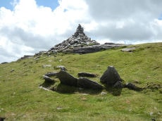
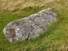
High Willhays Clearance Cairn
OS Map: SX 5802 8921
HER: MDV28576
ShortName: CN-HighWill 1
Grinsell: B:OKE 5b
Notes: Modern stone-heap on outcrop. In the photo the modern heap can be seen as can High Willhays Stone Ring Cairn Circle SiteID=565 in the foreground.
Nearby sites: SX 5802 8921
Distance: 0.84km
Higher Tor S.1 (duplicate) Reported Cist
OS Map: SX 609 915
HER: MDV6901
ShortName: CT:HigherTrDup
Notes: This is a likely duplicate of the Winter Tor cist entry HER MDV 6881. The HER entry for this record states: Possible cist noted at Winter Tor; this could not be located during MPP field investigation.. However, there s also a reference to barrow Report 21 which has an entry for winter Tor cists which in turn on p.146 references Prowse's Taw marsh article of 1890. That article has a plan of the cist in Fig 2 and Fig 3 which shows the stones of MDV 6881.
Nearby sites: SX 609 915
Distance: 2.88km
Oke Tor Reported Cist
OS Map: SX 61202 90099
HER: MDV6936
PMD: Oke Tor
ShortName: CT?OkeTor 1
Grinsell: LYD 2b
Notes: Dubious. A stone row on the western slopes of oke tor. The stone row runs a little north of west and south of east directly downhill towards the river(east okement). It is single, and runs between two large stone slabs which probably once formed part of cists, and at the further end two large stones lying prone within 2m of each other. One of the two slabs is set amidst other stones which may have formed a circle. Between the slabs is a fallen stone.(worth). Grinsell gives ngr 610-902- for apparently the same site. The cist is contained in the remains of a cairn. Not found. See also Oke Tor Reported Stone Row. Butler Vol 2 p.206.
Nearby sites: SX 61202 90099
Distance: 2.71km
Halstock Down 7 Reported Cist
OS Map: SX 5984 9224
HER: MDV60255
ShortName: CT:Halstock 7
Notes: Cairn and cist 830m S of moorgate farm. Update 13/12/2024 This was formerly listed as Moorgate Farm and marked here as a duplicate. Name changed to East Bowden 6 as appears to be part of that group. The HER record states "Location needs checking against Okehampton survey data.". The location on the HER record is nearly 0.8 km South of the Moor gate 1 record (MDV70198). East Bowden 3 (MDV60254) is around 100 metres away but has no reported cist. This suggests it may NOT be a duplicate and as such this record has been restored.
Nearby sites: SX 5984 9224
Distance: 2.70km
Okement Hill N. Reported Cairn
OS Map: SX 603 880
ShortName: CN?OkementN
Butler map: 42.9
Notes: Butler: Crossing recorded two more cairns in the area". The NMR record has a slightly different guessed NGR.
Nearby sites: SX 603 880
Distance: 2.62km
Okement Hill Summit Reported Cairn
OS Map: SX 603 877
HER: MDV4369
ShortName: CNxOkementSum
Butler map: 42.9
Grinsell: LYD 5a
Notes: Doubtful - probable peat stack. NGR supplied by Grinsell.
Nearby sites: SX 603 877
Distance: 2.84km
High Willhays (Crossing) Reported Cairn
OS Map: SX 580 897
HER: MDV20153
ShortName: CN?HighWill 2
Grinsell: OKE 5a
Notes: Very likely same as Oke 5. Account from Crossing 1905
Nearby sites: SX 580 897
Distance: 0.54km

East Mill Tor Reported Cairn
OS Map: SX 59953 89302
HER: MDV12849
ShortName: CN:East Mill
Notes: HER: There is no ground evidence to suggest the presence of the cairn described by source (1). However, a stoney mound 0.6m high lies at SX 59948928 and forms part of the retaining bank of a small tinners' reservoir (SX 58 NE 29). If taken in isolation this feature may be confused with a prehistoric cairn.
Prowse: A small tumulus a short distance south of East Miltor (East Mill Tor) and due east of High Willis (High Willhays).
Nearby sites: SX 59953 89302
Distance: 1.57km
West Mill Tor Reported Cairn
OS Map: SX 5898 9060
HER: MDV103614
ShortName: CN:West Mill
Notes: HER: Two small cairns at SX 58989060 and SX 58989059 and a short length of a low, spread boulder/stone bank indicate stone clearance activity. Whether the amorphous bank was intended to be the start of a newtake bank is not clear. (It extends from SX58959059 to SX 59069059).
Nearby sites: SX 5898 9060
Distance: 0.85km
Yes Tor N.W. Cairnfield Master
OS Map: SX 5723 9100
HER: MDV134416
ShortName: CN?YesTorN M
Butler map: 42.7.1
Notes: Master record for 3 clearance cairns, see individual records. This record marked as a duplicate as a master record.
Nearby sites: SX 5723 9100
Distance: 1.68km
Halstock Down Cairnfield Master
OS Map: SX 5959 9214
HER: MDV58789
ShortName: CN:Halstock M
Notes: HER: A cluster of 34 small clearance cairns and fragments of an apparently contemporary field system lie on the western flank of Halstock Down adjacent to the military ring road. The cairns vary in size from 1.7 metres to 6.9 metres in diameter and stand between 0.25 and 0.6 metres high. The majority (25) of these features are sub-circular, the remainder being definitely ovoid or linear in plan. One example is square. Bank fragments are now thought to be from the later prehistoric or even historic period and may not indicate fields
Nearby sites: SX 5959 9214
Distance: 2.49km
Longstone Hill (c.24) Cairnfield Master
OS Map: SX 568 908
HER: MDV5577
ShortName: CN:Longstone M
Butler map: 42.8
Notes: HER: A cairnfield containing 39 small irregular cairns on the crest and upper slopes of Longstone Hill. The majority relate to stone clearance activity perhaps during a period when the area was considered suitable for cultivation or simply to gather stone for use elsewhere. Features were recorded and scheduled in 1994 as a Bronze Age cairnfield. Ground survey in 2004 shed doubt on this identification and suggests these are clearance cairns.
This record has been separated out into individual entries, hence marked as a duplicate. It is the master record.
Nearby sites: SX 568 908
Distance: 1.92km
Homerton Hill (c.20) Cairnfield Master
OS Map: SX 561 905
HER: MDV12886
ShortName: CN:Homerton M
Butler map: 43.15
Notes: HER: Remains include a hut circle, lengths of turf-covered stony bank forming part of the associated field system which covers an area of approximately 2.0 hectares and at least twenty small clearance cairns. Several of the clearance cairns appear to have been confused with sepulchral monuments in the past and display shallow delvings in their tops. When combined with the incomplete nature of the field system the cairns suggest that the phase of enclosure in this area occurred in the later Prehistoric period and remained unfinished. Somewhat unusually for Dartmoor the field system encloses an earlier prehistoric ring cairn.
This is the master record for a cairn cemetery and as such set as a duplicate record. See individual entries.
Nearby sites: SX 561 905
Distance: 2.47km
Black Down W. Platform Cairn Circle and Cist
OS Map: SX 57398 91540
HER: MDV61332
Megalithic Portal: 45801
PMD: Black Down
ShortName: CT:BlackDown W
Butler map: 42.6
Butler Vol 5: p.58 & Fig.35
Notes: Not located at SX 57409153 on 28/08/16. Butler SX57389153. NMR SX57469153."The cairn is 6 metres in diameter and 0.7 metres in height. The cist is 0.9 metres long with 2 end stones in the original position. Remains of a kerb are visible around the north west edge of the mound". 1.6km east of Higher Bowden. nb. Not listed by Turner - assigned as "Platform Circle" type cairn due to description in NMR. "A flat-topped cairn". Butler Black Down W. Vol. 2. Map 42.6 (diagram Vol 5. p.58).
Nearby sites: SX 57398 91540
Distance: 1.98km
Blackaven Brook Cairn
OS Map: SX 60117 91909
HER: MDV59588
Alternate name: Harter Hill Cairn
ShortName: CN:Blackaven
Butler map: 42.4
Nearby sites: SX 60117 91909
Distance: 2.58km
Fordsland Ledge Chambered Cairn
OS Map: SX 57581 88897
HER: MDV3169
Megalithic Portal: 36418
PMD: Fordsland Ledge
ShortName: CN Fordsland
Butler map: 42.3
Butler Vol 5: p.160 & Fig.98
Grinsell: OKE 4
Notes: " In a crest position on Fordsland Ledge at 581.0m OD is the disturbed remains of a turf-and-heather-covered cairn. It measures 12.2m by 13.9m in diameter and is 1.1m high. In a hollow in the centre are a number of large stones suggesting the possibility of a former cist or even a chamber, utilizing the natural outcrop as its base." "The large stones visible in the centre of the feature are somewhat unusual and not typical of a cist-like structure. The presence of a chamber is very doubtful and it is more likely that the interior of the cairn has, at some point, been remodelled to create a small shelter."
Nearby sites: SX 57581 88897
Distance: 1.36km
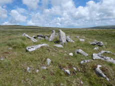
High Willhays Stone Ring Cairn Circle
OS Map: SX 58032 89224
HER: MDV21296
Megalithic Portal: 36417
ShortName: RC HighWill
Butler map: 42.2
Turner: A65
Notes: "Higher willhayes ring cairn. Irregular segment of stone ring set against rock outcrop.10m wide n-s and 5.5m radius to outcrop, with bank 1m wide and 0.2m high. Also contains segment of stone setting 7.5m wide n-s, 2.5m radius to outcrop"
Nearby sites: SX 58032 89224
Distance: 0.82km
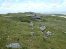
High Willhays (N) Stone Ring Cairn Circle
OS Map: SX 58020 89440
HER: MDV20152
Megalithic Portal: 45849
ShortName: RC:HighWill N
Grinsell: OKE 5
Turner: A64
Notes: "A revetted mound adjoins the south side of one of the granite outcrops at High Willhays. Measuring 19 metres east to west by 18 metres overall it stands around 0.8 metres high. The sides of the mound are formed by coursed granite slabs and boulders and the top is largely flat though a hollow has formed in the southern half."
Nearby sites: SX 58020 89440
Distance: 0.66km
Homerton Hill N. Cist
OS Map: SX 56132 90651
HER: MDV12884
Megalithic Portal: 45808
PMD: Homerton Hill
ShortName: CT Homerton N
Butler map: 43.15
Butler Vol 5: p.177 & Fig.119
DPD page: 157
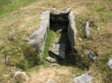
Notes: Butler Homerton Hill N. Vol. 2. Map 43.15 (diagram Vol. 5. p.177). A small, disturbed cairn containing three edge set stones of a cist ... The turf covered cairn measures 3.5 x 3.1m and 0.3m max. height. The top and north side of the mound has been disturbed exposing the three in situ cist stones. The cist measures 0.8 x 0.6m and 0.3mdeep. It is now open to the north. A large stone lying flush with the ground lies immediately north east of the cairn and probably represents the missing endstone or the coverstone. Lethbridge diagram p.156 and photos p157.
Nearby sites: SX 56132 90651
Distance: 2.48km
Longstone Hill Standing Stone
OS Map: SX 56725 90890
HER: MDV5571
Megalithic Portal: 36422
PMD: Longstone Hill Standing Stone
ShortName: SS Longstone
Butler map: 42.
Butler Vol 5: p.220
DPD page: 156
Notes: Possible recumbent longstone on summit of Longstone Hill, east of Meldon Reservoir. Suggested as possible menhir by Butler and Newman. Historic England:A sinuous 50 metres long, 2 metres wide and 0.25 metres high bank lying within the monument leads towards a large recumbent stone. This stone measures 1.75 metres long, 0.8 metres wide and 0.45 metres thick and is the only large stone visible on Longstone Hill. It has been suggested that this may be the longstone which once stood upright to give the hill its name. The presence of this stone, which would have been broadly contemporary with the cairns, provides additional support for the ritual and funerary character ascribed to many cairns within the group.
Nearby sites: SX 56725 90890
Distance: 2.03km
Oke Tor Reported Stone Row
OS Map: SX 61202 90099
HER: MDV4375
PMD: Oke Tor
ShortName: SR?OkeTor
Notes: Dubious. A stone row on the western slopes of oke tor. The stone row runs a little north of west and south of east directly downhill towards the river(east okement). It is single, and runs between two large stone slabs which probably once formed part of cists, and at the further end two large stones lying prone within 2m of each other. One of the two slabs is set amidst other stones which may have formed a circle. Between the slabs is a fallen stone.(worth). Grinsell gives ngr 610-902 for apparently the same site. The cist is contained in the remains of a cairn. Not found. NB. This record is duplicated here as a reported stone row. It is also duplicated on the HER. See also: Oke Tor Reported Cist Butler Vol 2 p.206.
Nearby sites: SX 61202 90099
Distance: 2.71km
West Mill Tor Reported Stone Row
OS Map: SX 5878 9078
HER: MDV11812
ShortName: SR:West Mill
Notes: HER: A double stone row thought to be of prehistoric date comprises 35 surviving stones, of which 7 are recumbent. The original arrangement may have included 64 stones. They now stand at a distance of 9m between rows as slabs set on edge and in line averaging 0.15m thick, 0.5m long and 0.4m high. A sinuous double row of set stones lies across the summit area of a moorland ridge. Its origins and function are obscure but it may be associated with military activity, possibly a trackway.
Nearby sites: SX 5878 9078
Distance: 0.92km
Winter Tor Cist
OS Map: SX 61112 91352
HER: MDV6881
Megalithic Portal: 45779
PMD: Winter Tor
Alternate name: Higher Tor S.1 Cist
ShortName: CT HigherTor 1
Butler map: 40.15
Butler Vol 5: p.169 & Fig.108
Grinsell: LYD 1
Notes: [Formerly listed as Higher Tor (S), renamed after PMD] Butler Higher Tor (S) Vol. 2. Map 40.15. (diagram Vol. 5. p.169). Ths cist was excavated by Prowse as described in his article of 1890. About 300 yards south-south-east of Winter Tor is a tumulus diameter 9 yards and height 3 feet, the top of which has been hollowed out. Within the hollow was a granite slab 4 feet 6 inches by 2 feet 9 inches, covering the remains of a cist, and another slab approximately 4 feet 9 inches by 3 feet 3 inches, either a second capstone or possibly part of the first cist. The cist contained nothing of interest except a few small porous and very brittle fragments of what is apparently bony tissue. After examination the capstone was replaced and covered with soil and stones.
Nearby sites: SX 61112 91352
Distance: 2.99km
Yes Tor E Cairn
OS Map: SX 58044 90185
HER: MDV4814
Megalithic Portal: 36416
Alternate name: Yes Tor 2 Cairn
ShortName: CN Yes Tor E
Butler map: 42.1.2
Grinsell: OKE 2
Notes: One of two cairns on Yes Tor. On the top of the flat outcrop of Yes Tor and piled against the west side is an amorphous mass of stones representing a ruined cairn. The patch of stones on the top is more or less 14.0m across and 0.3 m high and the piling against the outcrop is 2.3m high. It is possible that this has resulted from bulldozing the cairn over the side of the outcrop but the stones appear quite stable and compacted.
Nearby sites: SX 58044 90185
Distance: 0.54km
Yes Tor W Cairn
OS Map: SX 57955 90210
HER: MDV4813
Megalithic Portal: 36416
Alternate name: Yes Tor 1 Cairn
ShortName: CN Yes Tor W
Butler map: 42.1.1
Grinsell: OKE 1
Notes: Western of two round barrows on the summit of yes tor. About 36.6m nw of flag staff on the top of yes tor is an incomplete ring of rough granite boulders varying in size but generally 0.3m - 0.9m. Long. The ring is about 6.1m long and is defective on the north east side where there is evidence of a slightly sunken trackway. In the interior of this ring the ground is slightly irregular and contains blocks of granite. At the south western part of the circle a smaller circle of stones abuts on the previous circle. Butler Volume 2 Map 42.1.
Nearby sites: SX 57955 90210
Distance: 0.63km