
Prehistoric sites within 2km of SX 65600 70700
Guidance for walkers: The monuments featured in this database are archaeological treasures and need to be protected and preserved - please do not disturb any sites. Please check access and firing times before visiting sites, not all sites listed are on open access land. Firing ranges and boundaries of open access areas are marked on the OL28 OS Dartmoor Explorer map. Please stick to the country code and consider giving support to the numerous agencies that help to keep Dartmoor a fabulous natural and historic environment!
About the database listings: In all listings clicking on the photo or the site name will open a page for the site with a larger photo and further details from the database. The database now has over 6680 records covering nearly all publicly listed sites on Dartmoor including around 4800 round houses. This level of detail is of interest to archaeologists but tends to swamp listings of sites more likely to be of interest for walkers. For this reason, the listings default to around 550 core sites only. These are the stone circles, stone rows and the ring cairns listed by Turner. The default search radius is 2 km. The controls below the map can be used to start a new search by entering a 6- or 8-digit reference (without the prefix "SX"). The search radius can be specified and you can add incremental Display layers of detail on top of the core sites. If using a more detailed layer you will need to decrease the search radius to avoid getting hundreds of search results.
- Core sites Default listing of core sites consisting of stone circles & rows and some of the major ring cairns.
- Plus cairns adds approx. 1000 cairns and other minor sites not included in the core listings but excluding round houses.
- Plus round houses adds approx. 4800 round houses.
- Plus non-sites adds in the records for sites that no longer exist or are not prehistoric sites.
- Plus duplicates adds records excluded as duplicates. Those maybe duplicate records in external listings (e.g. the Historic Environment Records). For example, some sites have been identified as cairns in some listings and interpreted as round houses in other listings and both records appear.
These listings have incorporated, matched up and merged all of the records from all of the major archaeological listings including: Worth, Grinsell, Turner, Butler, Bill Radcliffe, Sandy Gerrard, Megalithic Portal, the National Monument Records and the Historic Environment Records. The author would like to thank Bill, Sandy, the lovely people both at Megalithic Portal (especially Anne Tate who did an amazing job to link listings) and at ACE Archaeology for collaborative work over the years to synchronise and correct listings across the various websites which now interlink. A culmination of years of work the final merger of cairn records took 3 months of cross referencing in 2017 the result being a snapshot of the records at that time. This data has in turn been refined since by field work and research. The round house data was supplied by Sandy Gerrard. Grid references are in order of accuracy: from Google Earth satellite, if visible and found, from a Garmin GPS reading, if visited by the author and from the literature otherwise. Individual site pages will state the source of the grid reference and provide satellite imagery. If a site listing lacks a photo it has not yet been visited by the author in which case the grid reference is from the literature.
Currently the database only includes sites which can be represented by a grid reference. Reaves are not included as they require GIS shape technology which is beyond the current capability of this system. To see the sources for the records, look at the tables on the resources menu. The database listings can also be viewed on a Google map and downloaded as GPS datasets for Garmin devices.
Corrections, or any feedback or suggestions are very welcome, email: info@dartmoorwalks.org.uk.
NOTE: Clicking on the icons for each monument in the map will give the name of the site. You can zoom in and out and drag the map around.
List of sites within 2km of SX 65600 70700
Down Ridge Stone Circle
OS Map: SX 65516 72084
HER: MDV6400
Megalithic Portal: 863
PMD: Down Ridge Stone Circle
ShortName: SC DownRidge
DPD page: 92
Turner: G9
Notes: Also known as Hexworthy Circle. "situated on a gentle north facing slope overlooking the valley of the River Dart. The stone circle measures 25 meters in diameter and is denoted by five upright granite slabs, standing up to 1.45 meters high, which are confined to its south western sector. A further six recumbent stones lie where they have fallen. The stone circle was partially excavated in 1904 by the Dartmoor Exploration Committee and their work revealed the original ground surface covered with charcoal. An associated outlying standing stone is located 85 meters south-east of the stone circle and survives as a triangular shaped block up to 0.86 meters high." [HER MDV6400]. For photos of this site, see: Megalithic Portal: Down Ridge - Stone Circle
Nearby sites: SX 65516 72084
Distance: 1.39km
Holne Moor Stone Ring Cairn Circle
OS Map: SX 66919 70785
HER: MDV6474
Megalithic Portal: 27342
Alternate name: Holne Ridge N.9 Stone Ring Cairn Circle
ShortName: RC HolneRidg 9
Butler map: 60.26.9
Grinsell: HOL 5
Turner: A12
Notes: "One of four cairns 310 metres south of Horn's Cross forming part of a cairn cemetery on Holne Ridge. Ring cairn measuring 19.9 metres in diameter, height 0.9 metres. Has a 4 metre wide bank standing up to 0.9 metres high surrounding an 11.9 metre diameter internal area. A stone on the inner face of the east side of the cairn has been cut by tear and feather."
Nearby sites: SX 66919 70785
Distance: 1.32km
Holne Moor Stone Row
OS Map: SX 67431 71042
HER: MDV12983
Megalithic Portal: 1981
The Stone Rows of GB: Holne Moor
PMD: Holne Moor Stone Row
ShortName: SR Holne Moor
Butler map: 60.25
DPD page: 90
Notes: "A standing stone and triple stone row lying in a secluded position, across the head of a shallow, north facing valley. It measures 147 metres long with rows on average 1.5 m apart. The stones, fifty three of which were located, have a maximum height of 0.2 m and are spaced about 1.1 m apart, each opposite the stone of the adjacent row. There is also a possible former standing stone which is now recumbent." See also MDV129985
Nearby sites: SX 67431 71042
Distance: 1.86km
Holne Ridge Stone Row
OS Map: SX 66741 71080
HER: MDV61453
Megalithic Portal: 27341
The Stone Rows of GB: Holne Ridge
PMD: Holne Ridge Stone Row
Alternate name: Holne Ridge North Stone Row
ShortName: SR Holne Ridge
Butler map: 60.26
DPD page: 90
Notes: "One or two cairns and a short probably unfinished stone row lie in the north west facing hollow above Horse Ford on the O Brook. The cairn described by Authority 2 lies at the south end of the site with the surviving stones of the stone row to the north. As so few stones survive the exact form and extent of the rows is impossible to determine but there may have been as many as three parallel rows approximately 1.0 metre apart. Overlying or abutting the east row at SX 6672 7109 is a low turf covered mound 3.0 metes in diameter and 0.4 metres high. It is not clear whether this feature forms part of the monument or if it is associated with the shallow turf cuttings to the east."
Nearby sites: SX 66741 71080
Distance: 1.20km
Holne Ridge N. Cist
OS Map: SX 66641 71138
HER: MDV12997
Megalithic Portal: 45800
PMD: Holne Ridge N.
Alternate name: Holne Ridge N.3 Cist
ShortName: CT HolneRidg 3
Butler map: 60.26.3
DPD page: 91
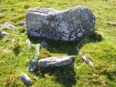
Notes: Butler Cist 3 Vol. 4. Map 60.26 (diagram p.195). "A probable but unusual cist is on steep well drained, NW facing slope. It utilizes the south east side of a massive slab, 1.6m long, 0.4m thick and 0.7m high, with smaller slabs 0.6m to 0.9m long and 0.2m thick, which barely project above ground level". NW of of Holne Ridge stone row. Lethbridge p.90-91, diagram p.90, photo bottom p.91
Nearby sites: SX 66641 71138
Distance: 1.13km
Horns Cross Stone Ring Cairn Circle
OS Map: SX 66921 71125
HER: MDV6475
Megalithic Portal: 27342
Alternate name: Holne Ridge N.6 Stone Ring Cairn Circle
ShortName: RC:HolneRidg 6
Butler map: 60.26.6
DPD page: 90
Grinsell: HOL 3
Turner: A35
Notes: "Remains of cairn; one of eight cairns forming part of a cairn cemetery on Holne Ridge. Truncated cairn, or ring cairn, gap in north-east. Diameter 14 metres, height 0.3 metres."
Nearby sites: SX 66921 71125
Distance: 1.39km
Horns Cross N. Cairn
OS Map: SX 66941 71187
HER: MDV26276
Megalithic Portal: 27342
Alternate name: Holne Ridge N.5 Cairn
ShortName: CN HolneRidg 5
Butler map: 60.26.5
Grinsell: HOL 2
Notes: "A turf and bracken covered Bronze Age cairn forming part of a cairn cemetery on Holne Ridge. The mound measures 14 metres by 14.4 metres in diameter and standing to a height of 1.4 metres. " Butler cairn 5 map 60.15. UPDATE 03/01/2023 This record formerly linked with MDV12975 which has been deleted.
It is unclear but this record now realte to MDV26276 which is a "tin-working spoil dump".
Nearby sites: SX 66941 71187
Distance: 1.43km
Skir Hill (Henroost) Ring Setting Cairn and Cist
OS Map: SX 65104 70686
HER: MDV6507
Megalithic Portal: 45676
PMD: Skir Hill
Alternate name: Skir Hill Ring Setting Cairn and Cist
ShortName: CT Skir Hill
Butler map: 61.8
DPD page: 92
Grinsell: LYD 102
Turner: D18
Barrow Report: 24 56
Notes: DM reports it is actually located at SX 65092 70684. The author has found this site at SX 65104 70691 on 28/06/18 assisted by the grid reference given by Dave Martin (DM). "A Bronze Age cairn containing a cist located on the north east facing slope of Skir Hill 590 metres south of Skir Ford. The cairn survives as a 4.1 diameter ring of edge set slabs up to 0.5 metres high. The cist is situated slightly west of the cairns centre and survives as a 0.82 metres long by 0.52 metres wide and 0.82 metres deep stone lined pit." Formerly listed as being at SX 6517 7075 (as per literature). Butler Vol. 4. Map 61.8 (diagram p.203).
Nearby sites: SX 65104 70686
Distance: 0.50km