
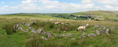
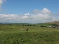
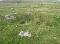
Prehistoric sites within 2km of SX 56700 73300
Guidance for walkers: The monuments featured in this database are archaeological treasures and need to be protected and preserved - please do not disturb any sites. Please check access and firing times before visiting sites, not all sites listed are on open access land. Firing ranges and boundaries of open access areas are marked on the OL28 OS Dartmoor Explorer map. Please stick to the country code and consider giving support to the numerous agencies that help to keep Dartmoor a fabulous natural and historic environment!
About the database listings: In all listings clicking on the photo or the site name will open a page for the site with a larger photo and further details from the database. The database now has over 6680 records covering nearly all publicly listed sites on Dartmoor including around 4800 round houses. This level of detail is of interest to archaeologists but tends to swamp listings of sites more likely to be of interest for walkers. For this reason, the listings default to around 550 core sites only. These are the stone circles, stone rows and the ring cairns listed by Turner. The default search radius is 2 km. The controls below the map can be used to start a new search by entering a 6- or 8-digit reference (without the prefix "SX"). The search radius can be specified and you can add incremental Display layers of detail on top of the core sites. If using a more detailed layer you will need to decrease the search radius to avoid getting hundreds of search results.
- Core sites Default listing of core sites consisting of stone circles & rows and some of the major ring cairns.
- Plus cairns adds approx. 1000 cairns and other minor sites not included in the core listings but excluding round houses.
- Plus round houses adds approx. 4800 round houses.
- Plus non-sites adds in the records for sites that no longer exist or are not prehistoric sites.
- Plus duplicates adds records excluded as duplicates. Those maybe duplicate records in external listings (e.g. the Historic Environment Records). For example, some sites have been identified as cairns in some listings and interpreted as round houses in other listings and both records appear.
These listings have incorporated, matched up and merged all of the records from all of the major archaeological listings including: Worth, Grinsell, Turner, Butler, Bill Radcliffe, Sandy Gerrard, Megalithic Portal, the National Monument Records and the Historic Environment Records. The author would like to thank Bill, Sandy, the lovely people both at Megalithic Portal (especially Anne Tate who did an amazing job to link listings) and at ACE Archaeology for collaborative work over the years to synchronise and correct listings across the various websites which now interlink. A culmination of years of work the final merger of cairn records took 3 months of cross referencing in 2017 the result being a snapshot of the records at that time. This data has in turn been refined since by field work and research. The round house data was supplied by Sandy Gerrard. Grid references are in order of accuracy: from Google Earth satellite, if visible and found, from a Garmin GPS reading, if visited by the author and from the literature otherwise. Individual site pages will state the source of the grid reference and provide satellite imagery. If a site listing lacks a photo it has not yet been visited by the author in which case the grid reference is from the literature.
Currently the database only includes sites which can be represented by a grid reference. Reaves are not included as they require GIS shape technology which is beyond the current capability of this system. To see the sources for the records, look at the tables on the resources menu. The database listings can also be viewed on a Google map and downloaded as GPS datasets for Garmin devices.
Corrections, or any feedback or suggestions are very welcome, email: info@dartmoorwalks.org.uk.
NOTE: Clicking on the icons for each monument in the map will give the name of the site. You can zoom in and out and drag the map around.
List of sites within 2km of SX 56700 73300
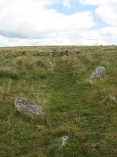
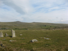
Black Tor (Stanlake) Stone Row
Prehistoric Dartmoor Walks: Dartmoor Walk: Sharpitor area Stone Rows and Cists
OS Map: SX 56988 71381
HER: MDV4994
Megalithic Portal: 1771
The Stone Rows of GB: Black Tor Stanlake
PMD: Black Tor Stanlake Stone Row
ShortName: SR Stanlake
Butler map: 45.14
DPD page: 24
Notes: "A Bronze Age Stone Row lies just inside, and is partly buried by, a substantial field boundary. The row extends from SX57217155 to SX57007137, some 294m long and includes at least 57 visible stones. Its north-eastern end is denoted by a substantial blocking stone and its lower south-western end by three funerary cairns. The row can be seen as three distinct parts forming the whole. The northern part includes 39 stones, the central group of 8 stones is separated from the northern row by a 66.2m wide gap whilst the southern group is on a slightly different alignment to the others. The row is unusual in that the blocking stone is at the upper end and a cairn lies at the lower end." Lethbridge diagram and photo p.24.
Nearby sites: SX 56988 71381
Distance: 1.94km
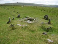
Devil's Elbow Platform Cairn Circle
OS Map: SX 58192 72708
HER: MDV14310
Megalithic Portal: 36761
PMD: Devil's Bridge
Alternate name: Hart Tor N. Platform Cairn Circle
ShortName: PC:DevilsElbow
Butler map: 46.1
Butler Vol 5: p.168 & Fig.107
Grinsell: WAL 10
Turner: E5
Notes: Ring cairn consisting of a circle of close set stones: almost a kerb circle, interior flat and no sign of cist. Diameter 8m, height 0.3m. HER: Ring cairn to the north-east of the settlement to the north of Hart Tor recorded in the 19th century as containing a 'dilapidated kistvaen'
Nearby sites: SX 58192 72708
Distance: 1.61km
Hart Tor N. Settlement
OS Map: SX 5816 7243
HER: MDV3791
Megalithic Portal: 36762
ShortName: ST:HartTorN
Nearby sites: SX 5816 7243
Distance: 1.70km
Hart Tor North Stone Row
Prehistoric Dartmoor Walks: Dartmoor Site: Hart Tor Stone Row & Cairn Circle
OS Map: SX 57708 71708
HER: MDV4896
Megalithic Portal: 1973
The Stone Rows of GB: Hart Tor North
PMD: Harter N Stone Row
ShortName: SR Hart Tor N
Butler map: 46.5.1
DPD page: 25
Notes: Butler Row 1. There are two cairns close by on the lower slopes of Hart Tor. One has an associated single stone row and the other has an associated double stone row - they diverge at an angle of 18 degrees.
Nearby sites: SX 57708 71708
Distance: 1.88km

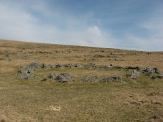
Hart Tor North Encircled Cairn
Prehistoric Dartmoor Walks: Dartmoor Site: Hart Tor Stone Row & Cairn Circle
OS Map: SX 57718 71716
HER: MDV49460
Megalithic Portal: 978
PMD: Harter N Stone Row
Alternate name: Hart Tor double stone row Encircled Cairn
ShortName: EC Hart Tor N
Butler map: 46.5
Butler Vol 5: p.39 & Fig.16
DPD page: 25
Grinsell: WAL 12
Turner: F12
Notes: The cairn circle is 9.3m across and consists of 14 tall slabs some of which have fallen. Wilkinson noticed concentric stone circles - which can't be seen today although there is clearly an inner circular mound. NMR A.
Nearby sites: SX 57718 71716
Distance: 1.88km
Hart Tor South Stone Row
Prehistoric Dartmoor Walks: Dartmoor Site: Hart Tor Stone Row & Cairn Circle
OS Map: SX 57720 71698
HER: MDV4895
Megalithic Portal: 1974
The Stone Rows of GB: Hart Tor South
PMD: Harter S Stone Row
ShortName: SR Hart Tor S
Butler map: 46.5.1
DPD page: 25
Notes: Butler Row 2. The single row consists of 16 stones and is 56.4m long, although Gerrard suggests it was probably once much longer. The single row leads to a cairn which does not have a retaining circle. The cairn which has been robbed measures 7.4m in diameter and up to 0.75m high. For early description of both rows and the now missing menhir, see: Wilkinson J. Gardner, British Remains on Dartmoor, Journal Brit. Arch. Assoc. xviii. pp.22-53 (1862). Detailed survey of site in Hart Tor Stone Rows & Cairns, Meavy Valley Archaeology. Site Report No.9 - Sandy Gerrard (1999).
Nearby sites: SX 57720 71698
Distance: 1.90km
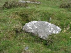
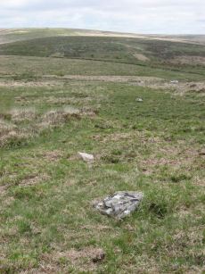
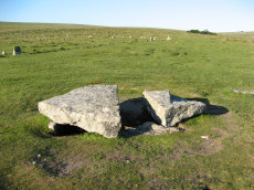
Ingra Tor Cist
Prehistoric Dartmoor Walks: Dartmoor Walk: Sharpitor area Stone Rows and Cists
OS Map: SX 55874 72093
HER: MDV4983
Megalithic Portal: 45735
PMD: Ingra Tor
Alternate name: lngra Tor Cist
ShortName: CT Ingra Tor
Butler map: 45.16
DPD page: 19
Grinsell: WAL 9
Barrow Report: 56
Notes: Butler Vol. 3. Map 45.16 (diagram p.51).
Breton (p.12): About 300 yds E. of Ingra tor is a fine kistvaen which has not been disturbed, except that a portion of the capstone has been broken off. [...] Three men from the farm near by about 1910 tried to raise the capstone with crowbars, but they failed to move it ; however, they broke off the piece that is broken.
Nearby sites: SX 55874 72093
Distance: 1.46km
Leeden Tor Stone Row
Prehistoric Dartmoor Walks: Dartmoor Walk: Sharpitor area Stone Rows and Cists
OS Map: SX 56522 71474
HER: MDV50223
Megalithic Portal: 2020
The Stone Rows of GB: Leeden Tor
PMD: Leeden Tor Stone Row
ShortName: SR Leeden Tor
Butler map: 45.15
DPD page: 23
Notes: "BA cairn and stone row. The scrappy remains of a single stone row now 165m long descend from a badly battered cairn on the south-east slopes of Leeden Tor. The cairn is about 6m across with a large central pit and partial retaining circle. At least 14 stones remain in a line, four only still earthfast and the rest either flat or buried. Stone pits record the loss of some of the stones". Lethbridge p23, diagram p.24. See also: Sea Views at Leeden Tor
Nearby sites: SX 56522 71474
Distance: 1.83km
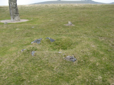
Merivale (S) Encircled Cairn
OS Map: SX 55368 74602
HER: MDV3759
Megalithic Portal: 52014
The Stone Rows of GB: Merrivale 4
PMD: Merrivale Menhir
Alternate name: Merrivale 6 (near standing stone) Encircled Cairn
ShortName: EC Merrivale 6
Butler map: 44.8.6
Grinsell: WAL 6
Turner: F19
Notes: The cairn now turf-covered with an excavation pit in the centre, has a diameter of 2.4m. and a height of 0.1m. The excavation pit can be seen in the photo. A very irregular "circle" of stones can be seen around this cairn. Turner F19.
Nearby sites: SX 55368 74602
Distance: 1.86km
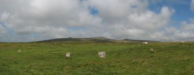
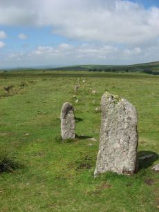
Merrivale Stone Circle
Prehistoric Dartmoor Walks: Dartmoor Site: Merrivale Ceremonial Complex [Photo Set 2]
OS Map: SX 55361 74641
HER: MDV4998
Megalithic Portal: 116
PMD: Merrivale Stone Circle
ShortName: SC Merrivale
DPD page: 17
Turner: G14
Notes: "A stone circle with a diameter of 20.0m. measured from northeast to southwest and 18.0m from northwest to southeast. It is formed by eleven stones spaced between 2.7m and 6.7m. apart and from 0.3m. to 0.5m. high. Three of the stones are of post type and eight are upright slabs. An additional stone, 7.5m. from the northeast side and 0.3m high, is angled towards the circle and may be quite unassociated".
Nearby sites: SX 55361 74641
Distance: 1.90km
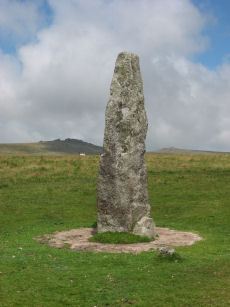
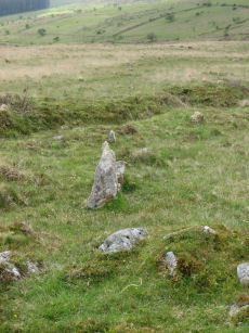
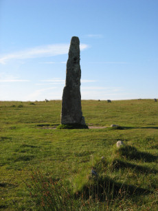
Merrivale Standing Stone
Prehistoric Dartmoor Walks: Dartmoor Site: Merrivale Ceremonial Complex [Photo Set 2]
OS Map: SX 55359 74599
HER: MDV53395
Megalithic Portal: 115
PMD: Merrivale Standing Stone
ShortName: SS Merrivale
Butler map: 44.8.4
DPD page: 17
Notes: "Two Bronze Age standing stones with a disturbed cairn and a number of small earth fast stones. Located in open generally clitter-free moorland. Only one of the two stones still stands; it is 3.2 metres high and tapers from the base which is 0.7 by 0.5 metres in section. Whether the stone was once the focus or terminus of a stone rows is uncertain. The second stone is now fallen, it is 2.2 metres long, up to 0.4 metres wide and 0.3 metres thick. An adjacent 0.3 metre deep pit may be its socket hole. "
Nearby sites: SX 55359 74599
Distance: 1.87km
Merrivale Settlement
Prehistoric Dartmoor Walks: Dartmoor Site: Merrivale Ceremonial Complex [Photo Set 2]
OS Map: SX 555 749
HER: MDV4897
Megalithic Portal: 1520
ShortName: ST Merrivale
DPD page: 18
Notes: Merrivale Prehistoric Settlement is a partially enclosed stone hut circle settlement, including at least thirty six hut circles and four separate enclosures. Lethbridge pp.16-18, diagram p.16.
Nearby sites: SX 555 749
Distance: 2.00km
Merrivale Ceremonial Complex
Prehistoric Dartmoor Walks: Dartmoor Site: Merrivale Ceremonial Complex [Photo Set 2]
OS Map: SX 5545 7479
HER: MDV14795
Megalithic Portal: 2046
PMD: Merrivale
ShortName: CX Merrivale
DPD page: 16
Notes: The Merrivale Ceremonial Complex consists of a stone circle a large menhir and two double stone rows and burial cairns. See also: Legendary Dartmoor: Merrivale Ceremonial Complex. Lethbridge pp.16-18, diagram p.16.
Grinsell [Folklore 1976]: Formerly called the Potato Market or the Plague Market, perhaps from a time when goods were brought here for sale when the plague was raging in Tavistock. Bray 1879, letter ix; Crossing 1912/65, 94, note.
Nearby sites: SX 5545 7479
Distance: 1.94km
Merrivale Cist
Prehistoric Dartmoor Walks: Dartmoor Walk: Merrivale Complex
OS Map: SX 55490 74770
HER: MDV3738
Megalithic Portal: 10465
PMD: Merrivale
Alternate name: Merrivale 7 Cist
ShortName: CT Merrivale 7
Butler map: 44.8.7
DPD page: 18
Grinsell: WAL 5
Notes: HER: A very fine Bronze Age cist which measures internally 2.2 metres long by 0.9 metres wide and up to 0.8 metres deep. The triangular-shaped slab which forms the massive cover stone is up to 2.1metres wide and averages 0.4 metres thick; a central part has been removed by stone cutters revealing the water-filled cist and a broken fragment of the coverslab.
Nearby sites: SX 55490 74770
Distance: 1.90km
Merrivale Embanked Cairn Circle and Cist
OS Map: SX 55360 74747
HER: MDV4997
Megalithic Portal: 10503
PMD: Merrivale SW.
Alternate name: Merrivale 8 Embanked Cairn Circle and Cist
ShortName: CT Merrivale 8
Butler map: 44.8.8
Grinsell: WAL 1
Turner: B2
Notes: "The excavation of 1851 seems to have been thorough, completely destroying structural remains of both the cairn and the 'cist or inner circle',. There is now a circular turf covered area, 18.0m. in diameter, with random stones protruding through the surface. Off centre there is a hollow, 7.0m. by 4.0m. and 0.5m. deep." Butler Merrivale Vol. 3. Map 44.8.8 (pp.30-1).
Nearby sites: SX 55360 74747
Distance: 1.97km
Merrivale (Menhir 1) Stone Row
Prehistoric Dartmoor Walks: Dartmoor Site: Merrivale Ceremonial Complex [Photo Set 1]
OS Map: SX 55361 74592
HER: MDV53397
Megalithic Portal: 3388
The Stone Rows of GB: Merrivale 4
PMD: Merrivale Menhir I Stone Row
Alternate name: Merrivale 4 Stone Row
ShortName: SR Mer Menhir
Butler map: 44.8.4
DPD page: 17
Notes: Butler Row 4. Prehistoric Monuments of Dartmoor website Menhir 1. "Stone row 4 is now a trivial affair [Butler] of 3 small slabs aligned towards a squarish block near the base of the standing stone. This area has suffered some damage over the past century. There were 5 stones in 1895, the missing one presumably accounted for by the pit which has appeared between the upper stones. This may well be the site of the cairn, C4, at the head of the rows recorded by Rowe but not included in the plans of Lukis or Worth. Nor is there much surviving from the circle of slabs around the menhir depicted in Bray's plan and recorded by Spence Bate in 1871, or the nearby cist which he excavated, C5. The Exploration Committee excavated at both ends of the row but no more socket holes were found and they concluded that this short alignment was complete." Lethbridge pp.16-18, diagram p.16.
Nearby sites: SX 55361 74592
Distance: 1.86km
Merrivale A Stone Row
Prehistoric Dartmoor Walks: Dartmoor Site: Merrivale Ceremonial Complex [Photo Set 1]
OS Map: SX 55541 74809
HER: MDV14797
Megalithic Portal: 2044
The Stone Rows of GB: Merrivale 1
PMD: Merrivale A Stone Row
Alternate name: Merrivale 1 Stone Row
ShortName: SR MerrivaleA
Butler map: 44.8.1
DPD page: 16
Notes: Worth Merrivale A. Butler Merrivale 1. "Two Bronze Age double stone rows and associated cairns are located on open moorland. The rows are oriented roughly east to west and are almost parallel, being 25 metres between centres at their eastern ends increasing to 32 metres at the west. A leat still used to convey water to Hillside Stables separates the two monuments and flows to within 2 metres of the northern row. A single row (see SX 57 SE 115) runs roughly south-west from a small cairn at SX 55397476, some 4.75 metres south of the south row." Lethbridge pp.16-18, diagram p.16.
Nearby sites: SX 55541 74809
Distance: 1.90km
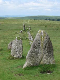
Merrivale B Stone Row
Prehistoric Dartmoor Walks: Dartmoor Site: Merrivale Ceremonial Complex [Photo Set 1]
OS Map: SX 55567 74788
HER: MDV14795
Megalithic Portal: 117
The Stone Rows of GB: Merrivale 2
PMD: Merrivale B Stone Row
Alternate name: Merrivale 2 Stone Row
ShortName: SR MerrivaleB
Butler map: 44.8.2
DPD page: 16
Notes: Butler Merrivale 2. Worth Merrivale B. For description see Merrivale A. Lethbridge pp.16-18, diagram p.16.
Nearby sites: SX 55567 74788
Distance: 1.87km
Merrivale C Stone Row
Prehistoric Dartmoor Walks: Dartmoor Site: Merrivale Ceremonial Complex [Photo Set 1]
OS Map: SX 55394 74761
HER: MDV5001
Megalithic Portal: 3391
The Stone Rows of GB: Merrivale 3
PMD: Merrivale C Stone Row
Alternate name: Merrivale 3 Stone Row
ShortName: SR MerrivaleC
Butler map: 44.8.3
DPD page: 17
Notes: "A stone row and a small cairn lie to the south of the double stone rows in close-cropped moorland turf. The cairn located at the northern end and slightly off-centre to the row, measures 3.2m across and up to 0.5m high. An 0.3m deep central pit opens out on the southern side."
Nearby sites: SX 55394 74761
Distance: 1.96km
Merrivale double row B (centre) Encircled Cairn and Cist
Prehistoric Dartmoor Walks: Dartmoor Walk: Merrivale Complex
OS Map: SX 55442 74779
HER: MDV14796
Megalithic Portal: 3389
PMD: Merrivale S row
Alternate name: Merrivale double row 2 centre Encircled Cairn and Cist
ShortName: CT Merrivale 2
Butler map: 44.8.2
DPD page: 17
Grinsell: WAL 4
Turner: F20
Notes: Butler Merrivale double row 2, (centre) - Vol. 3. Map 44.8.1 (diagram p.27). Lethbridge pp.16-18, diagram p.16.
Nearby sites: SX 55442 74779
Distance: 1.94km
Merrivale NE Cairn Circle
Prehistoric Dartmoor Walks: Dartmoor Site: Merrivale Ceremonial Complex [Photo Set 1]
OS Map: SX 55548 74817
HER: MDV29078
Megalithic Portal: 3390
The Stone Rows of GB: Merrivale 1
PMD: Merrivale A Stone Row
Alternate name: Merrivale double row 1 (east end) Cairn Circle
ShortName: CC Merrivale 1
Butler map: 44.8.1
Notes: At the eastern end (of the northern stone row) there is a blocking stone and beyond it a number of earthfast and loose slabs which seem to represent a former kerb or circle about 5.6m. in diameter. The blocking stone is part of the circle with two or possibly three earthfast slabs on end, three recumbent slabs, and four other post or slab stones which are much displaced or entirely unconnected. The stones are spaced at about 2.0m. intervals; uprooted slabs are from 0.3m. square to 0.4m. by 0.5m., earthfast stones 0.1m. high. There is no sign of a cairn or cist.
Nearby sites: SX 55548 74817
Distance: 1.90km
Routrundle North Enclosed Settlement
Prehistoric Dartmoor Walks: Dartmoor Walk: Sharpitor area Stone Rows and Cists
OS Map: SX 55384 71860
HER: MDV105688
Megalithic Portal: 45577
ShortName: ES:Routrundl N
Notes: Routrundle North Pound: "Broadly oval enclosure, 58 by 48 metres diameter. Part of the south-west perimeter is represented by a stony scarp 0.5 metres high, elsewhere it comprises a stone spread of similar height upon which is a modern field wall."
Nearby sites: SX 55384 71860
Distance: 1.95km
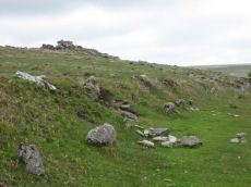
Walkhampton Enclosed Settlement
Prehistoric Dartmoor Walks: Dartmoor Site: Walkhampton and Yes Tor Bottom Settlements
OS Map: SX 56772 72867
HER: MDV4964
Megalithic Portal: 45325
ShortName: ES Walkhampton
Notes: "Hut circles 550m s of foggintor quarries. A very fine settlement, set within a well built and substantial enclosure wall, enclosing an area of some 1.0ha. Five hut circles occur within the enclosure varying between 6-10m in diam ... Outside the enclosure to the w are five further huts of similar dimensions - again one of these shows sign of alteration. Under moorland grass." The site was excavated in 1897 by Burnard and Baring-Gould.
Nearby sites: SX 56772 72867
Distance: 0.44km
Yellowmeade Farm Cist
OS Map: SX 56350 74465
HER: MDV5002
Megalithic Portal: 45778
PMD: Yellowmeade Farm NW.
Alternate name: Yellowmeade 1 Cist
ShortName: CT Yellowm Fm1
Butler map: 44.1.1
DPD page: 18
Grinsell: WAL 7
Barrow Report: 67
Notes: Butler Yellowmeade 1 - Vol. 3. Map 44.1 (diagram p.17).
Nearby sites: SX 56350 74465
Distance: 1.22km