
Prehistoric sites within 2km of SX 55020 78740
Guidance for walkers: The monuments featured in this database are archaeological treasures and need to be protected and preserved - please do not disturb any sites. Please check access and firing times before visiting sites, not all sites listed are on open access land. Firing ranges and boundaries of open access areas are marked on the OL28 OS Dartmoor Explorer map. Please stick to the country code and consider giving support to the numerous agencies that help to keep Dartmoor a fabulous natural and historic environment!
About the database listings: In all listings clicking on the photo or the site name will open a page for the site with a larger photo and further details from the database. The database now has over 6680 records covering nearly all publicly listed sites on Dartmoor including around 4800 round houses. This level of detail is of interest to archaeologists but tends to swamp listings of sites more likely to be of interest for walkers. For this reason, the listings default to around 550 core sites only. These are the stone circles, stone rows and the ring cairns listed by Turner. The default search radius is 2 km. The controls below the map can be used to start a new search by entering a 6- or 8-digit reference (without the prefix "SX"). The search radius can be specified and you can add incremental Display layers of detail on top of the core sites. If using a more detailed layer you will need to decrease the search radius to avoid getting hundreds of search results.
- Core sites Default listing of core sites consisting of stone circles & rows and some of the major ring cairns.
- Plus cairns adds approx. 1000 cairns and other minor sites not included in the core listings but excluding round houses.
- Plus round houses adds approx. 4800 round houses.
- Plus non-sites adds in the records for sites that no longer exist or are not prehistoric sites.
- Plus duplicates adds records excluded as duplicates. Those maybe duplicate records in external listings (e.g. the Historic Environment Records). For example, some sites have been identified as cairns in some listings and interpreted as round houses in other listings and both records appear.
These listings have incorporated, matched up and merged all of the records from all of the major archaeological listings including: Worth, Grinsell, Turner, Butler, Bill Radcliffe, Sandy Gerrard, Megalithic Portal, the National Monument Records and the Historic Environment Records. The author would like to thank Bill, Sandy, the lovely people both at Megalithic Portal (especially Anne Tate who did an amazing job to link listings) and at ACE Archaeology for collaborative work over the years to synchronise and correct listings across the various websites which now interlink. A culmination of years of work the final merger of cairn records took 3 months of cross referencing in 2017 the result being a snapshot of the records at that time. This data has in turn been refined since by field work and research. The round house data was supplied by Sandy Gerrard. Grid references are in order of accuracy: from Google Earth satellite, if visible and found, from a Garmin GPS reading, if visited by the author and from the literature otherwise. Individual site pages will state the source of the grid reference and provide satellite imagery. If a site listing lacks a photo it has not yet been visited by the author in which case the grid reference is from the literature.
Currently the database only includes sites which can be represented by a grid reference. Reaves are not included as they require GIS shape technology which is beyond the current capability of this system. To see the sources for the records, look at the tables on the resources menu. The database listings can also be viewed on a Google map and downloaded as GPS datasets for Garmin devices.
Corrections, or any feedback or suggestions are very welcome, email: info@dartmoorwalks.org.uk.
NOTE: Clicking on the icons for each monument in the map will give the name of the site. You can zoom in and out and drag the map around.
List of sites within 2km of SX 55020 78740
Langstone Moor S.2 Cairn
OS Map: SX 54838 77646
HER: MDV4116
Megalithic Portal: 35802
ShortName: CN Langston S2
Butler map: 31.19.2
Grinsell: PET 34
Notes: "Two round barrows on Peter Tavy Great Common. (A) SX54847764 A flat topped stony mound, probably a cairn, about 12m E-W by 11m transversely and of 0.6m maximum height. There is no apparent kerb and the edges are ill-defined. It is predominantly turf-covered but a small area of stones is exposed in the NW quadrant presumably the site of the 1899 excavation.(B) SX54887765 Located 45m ENE of 'A' or probable cairn visible as a turf covered mound about 5m in diameter and 0.3m high. No kerb is evident and the centre has been disturbed. The mounds are both quite prominently situated on the summit of a gently domed ridge of rough grassland which is generally devoid of surface stone."
Nearby sites: SX 54838 77646
Distance: 1.11km
White Tor S.S.W.1 Long Cairn
OS Map: SX 54023 78321
HER: MDV4179
ShortName: CN White SSW1
Butler map: 31.21.1
Grinsell: PET 29a
Notes: The Dartmoor Exploration Committee (Report 6 1899) describes investigating 3 cairns in this location. The damaged remains are difficult today to interpret. Many authors suggest that the long cairn consists of two or more of these cairns. The current author visited this location on 27th May 2022 with just the knowledge that there were 3 reported cairns. I photographed a very likely cairn, namely, the long cairn (Butler 1). A semi-circular bank (Butler 3) and a faint mound around a natural rock (Butler 2). I noted at the time of the visit that both 2 and 3 are possible but doubtful cairns. I did not have the Butler account with me at the time I photographed and logged these. Looking now at Butler's account it looks like he reached the same conclusions and the entries here follow Butler with similar doubt on Butler 2 and Butler 3.
Nearby sites: SX 54023 78321
Distance: 1.08km
Cudlipptown Down Embanked Cairn Circle
OS Map: SX 53732 78949
HER: MDV13252
Megalithic Portal: 45608
Alternate name: White Tor N.W.2 Embanked Cairn Circle
ShortName: CC White NW2
Butler map: 31.23.2
Butler Vol 5: p.188 & Fig.130
Grinsell: PET 21
Turner: B5
Notes: "A ring cairn set at the eastern end of a natural gently sloping plateau of rough grassland generally devoid of stones. It measures about 11m diameter inside a turf-covered bank, composed generally of smallish stones, which is about 2.2m wide and has a maximum height of 0.4m on the E. It has been mutilated and spread in the south-east and the west. Several stones, are evident, two probably set in the inner face but the rest are apparently part of the bank of even part of the outer face. Two in the east on the uphill side appear to form an entrance but this is possibly due to mutilation. The interior appears to have been levelled and is 0.2m above the ground to the W. There is no evidence of any internal features or a ditch"
Nearby sites: SX 53732 78949
Distance: 1.30km
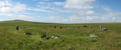
Langstone Moor Stone Circle
Prehistoric Dartmoor Walks: Dartmoor Site: Langstone Moor Stone Circle, Stone Row & Settlements
OS Map: SX 55638 78204
HER: MDV4226
Megalithic Portal: 1062
PMD: Langstone Moor Stone Circle
ShortName: SC Langstone
Butler map: 30.10
DPD page: 14
Turner: G10
Notes: The Langstone standing stone and also the stone circle were used for target practice by American troops who were stationed nearby during the Second World War. Bullet holes can be seen on the Langstone standing stone and the circle was sadly smashed to smithereens. The Langstone Moor Stone circle had been restored in 1894 when all of the stones were re-erected in their original socket holes.
Nearby sites: SX 55638 78204
Distance: 0.82km
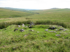
Langstone Moor Stone Ring Cairn Circle
Prehistoric Dartmoor Walks: Dartmoor Site: Langstone Moor Stone Circle, Stone Row & Settlements
OS Map: SX 54843 77922
HER: MDV48862
Megalithic Portal: 45833
ShortName: RC Langstone
Turner: A22
Notes: HER: A semi-circular bank, possibly the remains of a ring cairn.1.4 to 2m wide, 0.4m high. Composed of small + medium sized stones now largely turf-covered. It fades at each end of a near-perfect semi-circle of 14.9m internal diam. There is a low stone pile, 0.2m high, in se quadrant.
Nearby sites: SX 54843 77922
Distance: 0.84km
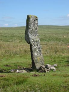
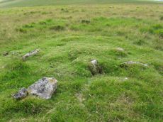
Langstone Moor Standing Stone
Prehistoric Dartmoor Walks: Dartmoor Site: Langstone Moor Stone Circle, Stone Row & Settlements
OS Map: SX 55023 78742
HER: MDV4225
Megalithic Portal: 17504
PMD: Langstone Moor Standing Stone
ShortName: SS Langstone
Butler map: 30.12
Butler Vol 5: p.230
DPD page: 13
Notes: The Langstone standing stone is 2.76m high and can be seen from some distance. It was restored in its original socket in 1893. The Langstone is close to a stone row consisting of very small stones. The Langstone standing stone and also the stone circle were used for target practice by American troops who were stationed nearby during the second world. Bullet holes can be seen on the Langstone standing stone. Lethbridge pp.13-14. Breton (p.17) The stone is composed of local gabbro, and was formerly prostrate, but His Grace the Duke of Bedford has re-erected it in its original socket-hole.
Nearby sites: SX 55023 78742
Distance: 0.00km
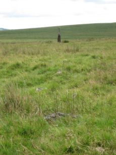
Langstone Moor Ancient Pool
OS Map: SX 55026 78879
HER: MDV127215
ShortName: PO:Langstone
Notes: HER: A pool measuring 28 by 24 metres. One of over 40 such 'sacred' pools identified on Dartmoor that are thought to have potentially been designed during the prehistoric period. Lies at the northern end of a stone row. May be on the site of a cairn
NB. HER entry implies this could be the same as the Butler reported cairn at the end of the stone row. On this website this is currently listed as a separate entry SiteID=1164 (no HER entry). The diagram page 77 (fig 30.8) shows both a mound and a pit. Could this be the pit distinct from the cairn? Breton (p.17): The Langstone was formerly the end of a stone row, composed of quite small stones, running in a direction N. and S. from a pool that occupies the site of a destroyed cairn.
Nearby sites: SX 55026 78879
Distance: 0.14km
Langstone Moor Settlement
OS Map: SX 555 779
HER: MDV4219
Megalithic Portal: 17507
ShortName: ST Langstone
Butler map: 30.2
Notes: Details via Megalithic Portal.
Nearby sites: SX 555 779
Distance: 0.97km
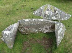
Langstone Moor Cist
Prehistoric Dartmoor Walks: Dartmoor Site: Langstone Moor Stone Circle, Stone Row & Settlements
OS Map: SX 54699 78695
HER: MDV4118
Megalithic Portal: 35807
PMD: White Tor E.
Alternate name: White Tor E.4 Cist
ShortName: CT White E4
Butler map: 31.22.4
Butler Vol 5: p.174 & Fig.114
DPD page: 13
Grinsell: PET 27
Barrow Report: 55
Notes: Butler White Tor E.4. Vol. 2. Map 31.22 (diagram Vol. 5. p.174).
Nearby sites: SX 54699 78695
Distance: 0.32km
Langstone Moor Stone Row
Prehistoric Dartmoor Walks: Dartmoor Site: Langstone Moor Stone Circle, Stone Row & Settlements
OS Map: SX 55022 78851
HER: MDV4223
Megalithic Portal: 2016
The Stone Rows of GB: Langstone Moor
PMD: Langstone Moor I Stone Row
ShortName: SR Langstone
Butler map: 30.12
DPD page: 14
Notes: "A single stone row stands on Launceston (Langstone). Moor circa 330 feet in length, probably longer when complete. There are now only 18 stones, the largest of which stands only 18 inches above ground. At the north end are the remains of a barrow, now reduced to little more than a rubble ring. At the south end is the standing stone known as the 'Langstone', from which the moor probably takes its name. The stone was re-erected in 1893 and stands to a height of 9 feet 3 inches." Lethbridge p14, diagram p13. Breton (p.17): The Langstone was formerly the end of a stone row, composed of quite small stones, running in a direction N. and S. from a pool that occupies the site of a destroyed cairn.
Nearby sites: SX 55022 78851
Distance: 0.11km
Langstone Moor 2 Cist
Prehistoric Dartmoor Walks: Dartmoor Site: Langstone Moor Stone Circle, Stone Row & Settlements
OS Map: SX 55736 78120
HER: MDV4593
Megalithic Portal: 45786
PMD: Near Langstone Moor Stone circle
ShortName: CT Langstone 2
Butler map: 30.10.2
Grinsell: PET 39
Notes: The cist is now housed in the Plymouth City Museum. Butler Langstone Moor 2 - Vol. 2. Map 30.10. 129
Nearby sites: SX 55736 78120
Distance: 0.95km

Roos Tor N.W. Settlement
OS Map: SX 539 772
HER: MDV4104
Megalithic Portal: 17509
ShortName: ST RoosTorNW
Notes: Details via Megalithic Portal. Photo is of round house SiteID=8089
Nearby sites: SX 539 772
Distance: 1.90km
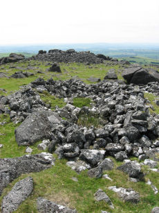
White Tor Stone Ring Cairn Circle
OS Map: SX 54597 78701
HER: MDV4164
Megalithic Portal: 35804
Alternate name: White Tor E.1 Stone Ring Cairn Circle
ShortName: RC White E1
Butler map: 31.22.1
Grinsell: PET 24
Turner: A26
Notes: See also duplicate 439800. Turner A26. Butler White Tor E.1. "Round cairn 340 metres east of White Tor summit. This monument includes a round cairn situated on a gentle south-east facing slope overlooking the valley of the River Walkham. The cairn mound measures 6m in diameter and stands up to 0.4m high. A hollow in the centre of the mound measuring 3m in diameter and 0.3m deep is the result of a partial excavation carried out by the Dartmoor Exploration Committee in 1899. This work recovered a perforated stone. A kerb of small stones defines the outer edge of the mound."
Nearby sites: SX 54597 78701
Distance: 0.42km
White Tor Fort
Prehistoric Dartmoor Walks: Dartmoor Site: White Tor Fort
OS Map: SX 54246 78678
HER: MDV4101
Megalithic Portal: 17506
ShortName: FT White Tor
DPD page: 13
Notes: The White Tor camp is a Neolithic Enclosure which was once assumed to have been repurposed as an Iron Age fort. There used to be a separate HER entry to this end but this has been removed as the consensus now is that it is predominantly a Neolithic feature.
Nearby sites: SX 54246 78678
Distance: 0.78km
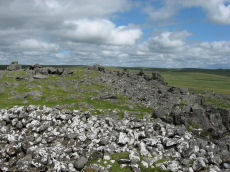
White Tor (Whittor) Neolithic Enclosure
Prehistoric Dartmoor Walks: Dartmoor Site: White Tor Fort
OS Map: SX 5423 7867
HER: MDV4101
Megalithic Portal: 17506
ShortName: NE White Tor
Butler map: 31.13
DPD page: 13
Notes: Neolithic tor enclosure. "A camp on the summit of White Tor formed by a double wall, now in ruinous condition. Both walls appear to have been 10 to 11 feet thick, the outer wall being 4 to 4 1/2 feet high, the inner 6 to 7 feet high. The distance between the walls varies between 10 and 40 feet. The entrances are to the east, where access is easier, they are not opposite and are protected by the spur walls. Within the camp are four hut circles and three possible hut shelters, and two northern circles (numbers 5 and 6 on plan) are joined by a short wall." See also, Legendary Dartmoor: Dartmoor's White Tor Neolithic Settlement. See also Dartmoor Tor Enclosures Project.
Nearby sites: SX 5423 7867
Distance: 0.79km