
Langstone Moor Stone Circle
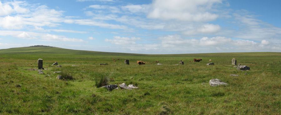
Photo taken on 25-07-2010
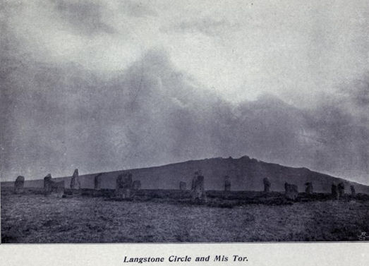
Langstone Stone Circle Restored, photo by Robert Burnard 1894
Database entries
PDW coverage: Dartmoor Site: Langstone Moor Stone Circle, Stone Row & Settlements
OS Map: SX 55638 78204
OS Source: Google
HER: MDV4226
Megalithic Portal: 1062
PMD: Langstone Moor Stone Circle
Alternate name: Langstone Moor
Short Name: SC Langstone
Butler map: 30.10
Turner: G10
DPD page: 14
Exist: Yes
Record: Unique
Record Source: PDW
Hut Class: No
Dimensions (m): 20.4
Lidar: SX 55638 78204
Guide Map: 24
Nearest Bus Stop: Merrivale Dartmoor Inn (4.0 km) [Route: 98,171(20/07/26 to 19/09/26)]
Nearby sites: SX 55638 78204
Notes
The Langstone standing stone and also the stone circle were used for target practice by American troops who were stationed nearby during the Second World War. Bullet holes can be seen on the Langstone standing stone and the circle was sadly smashed to smithereens. The Langstone Moor Stone circle had been restored in 1894 when all of the stones were re-erected in their original socket holes.Today only 3 stones remain intact with 10 having been destroyed and the rest overturned during World War Two. The debris of the former stones remain in place. Pre-war photos give a sense of how spectacular this site used to be. The original restored circle consisted of 16 stones in a 20.9m circle. The original survey by the Dartmoor Exploration Committee suggested that there might have originally been a secondary concentric circle consisting of elvan rather than granite stones although the evidence for this today is unclear (see Extract from the Second Report of the D.E.C.). Breton (p.18): It was discovered as recently as 1894. Not a single stone was then standing, but fortunately none had been taken away or even mutilated. The Duke of Bedford kindly allowed the stones to be re-erected, and supplied the men to do the work, which was directed by the Rev S. Baring-Gould and Mr. Robert Burnard. It has 16 stones, and its diameter is about 60 ft. There was originally another circle outside this one, of which only two or three stones remain. Further coverage can be found on Legendary Dartmoor: Dartmoor's Prehistoric Langstone Moor. Lethbridge p14, diagram p13.
References
These are selected references with an emphasis on out of copyright sources linked as PDFs. For more detailed references try any linked HER or PMD record above.
- Baring-Gould, Sabine, Second Report of the Dartmoor Exploration Committee, T.D.A. Vol.27 pp.81-92 (1895)
- Brailsford, J. W, Bronze Age Stone Monuments of Dartmoor, Antiquity Volume 12, Number 48 pp.444-63 (1938)
- Breton, Henry Hugh, The Heart of Dartmoor, (1926)
- Burnard, Robert, Dartmoor Pictorial Records, (1986)
- Butler, Jeremy, Dartmoor Atlas of Antiquities, vol.2: The North, (1991)
- Falcon, T.A., Dartmoor Illustrated, (1900)
- Gerrard, Sandy, English Heritage Book of Dartmoor: Landscapes Through Time, (1997)
- Newman, Phil, Archaeological Sites within Merrivale Training Area, Southwest Landscape Investigations (2018)
- Rowe, Samuel, A Perambulation of Dartmoor (3rd Edition), (1896)
- Turner, J.R., Ring Cairns, stone circles and related monuments on Dartmoor, D.A.S.P. No.48 pp.27-86 (1990)