
Langstone Moor Cist
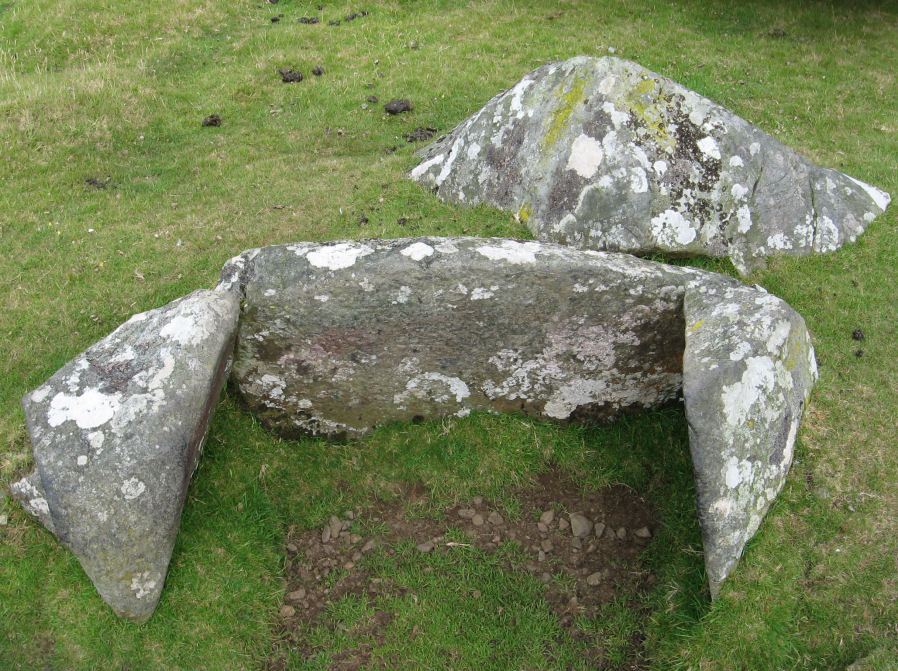
Photo taken on 19-07-2015
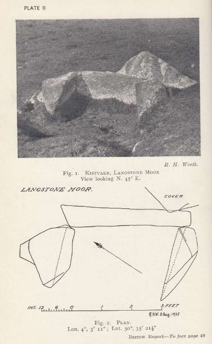
Plan by RHW. Barrow Report 55. TDA Vol.68 1936
Database entries
PDW coverage: Dartmoor Site: Langstone Moor Stone Circle, Stone Row & Settlements
OS Map: SX 54699 78695
OS Source: Google
Butler OS: SX54697869
HER: MDV4118
Megalithic Portal: 35807
PMD: White Tor E.
Alternate name: White Tor E.4
Short Name: CT White E4
Butler map: 31.22.4
Butler Vol 5: p.174 & Fig.114
Dixon Cist #: 65
Grinsell: PETER TAVY 27
DPD page: 13
Exist: Yes
Record: Unique
Record Source: Butler
Hut Class: No
Cist Class: Yes
Cairn Class: Yes
Barrow Report: 55
Dimensions (m): 6.3 x 0.3 C
Lidar: SX 54699 78695
Guide Map: 24
Nearest Bus Stop: Merrivale Dartmoor Inn (4.5 km) [Route: 98,171(20/07/26 to 19/09/26)]
Nearby sites: SX 54699 78695
Notes
Butler White Tor E.4. Vol. 2. Map 31.22 (diagram Vol. 5. p.174).References
These are selected references with an emphasis on out of copyright sources linked as PDFs. For more detailed references try any linked HER or PMD record above.
- Baring-Gould, Sabine, Sixth Report of the Dartmoor Exploration Committee, T.D.A. Vol.31 pp.146-155 (1899)
- Baring-Gould, Sabine, A Book of Dartmoor, (2002)
- Brailsford, J. W, Bronze Age Stone Monuments of Dartmoor, Antiquity Volume 12, Number 48 pp.444-63 (1938)
- Butler, Jeremy, Dartmoor Atlas of Antiquities, vol.2: The North, (1991)
- Butler, Jeremy, Dartmoor Atlas of Antiquities, vol.5: The Second Millennium B.C., (1997)
- Grinsell, L.V., Dartmoor Barrows, Devon Archaeological Society Proceedings No.36 (1978)
- Lethbridge, William D., Discover Preshistoric Dartmoor, (2015)
- Newman, Phil, The Langstone Moor Stone Circle, Peter Tavy, Devon and its Prehistoric Environs, English Heritage (2003)
- Newman, Phil, Archaeological Sites within Merrivale Training Area, Southwest Landscape Investigations (2018)
- Prowse, Arthur B., Notes on the Neighbourhood of White Tor, West Dartmoor, T.D.A. Vol.21 pp.166-170 (1889)
- Rowe, Samuel, A Perambulation of Dartmoor (3rd Edition), (1896)
- Worth, R. Hansford, Barrow Report 55, T.D.A. Vol.68 pp.49-50 (1936)