
White Tor (Whittor) Neolithic Enclosure
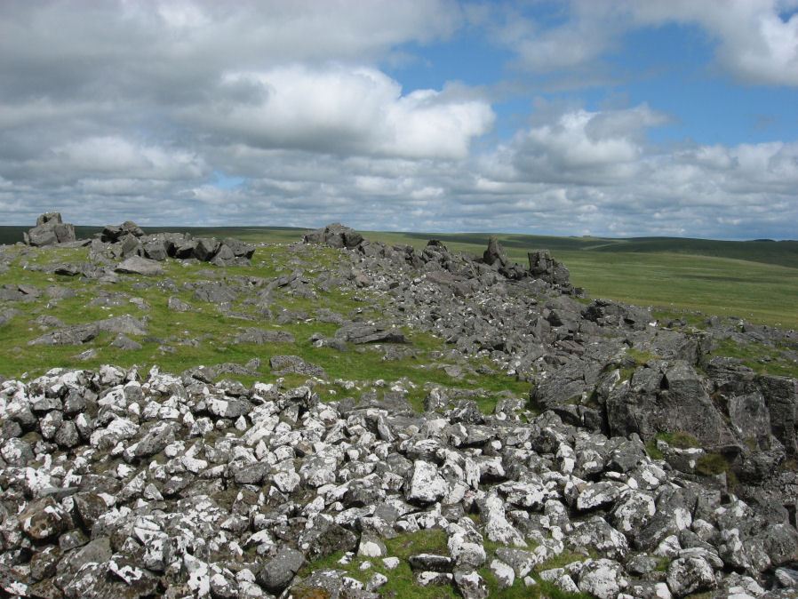
Photo taken on 19-07-2015
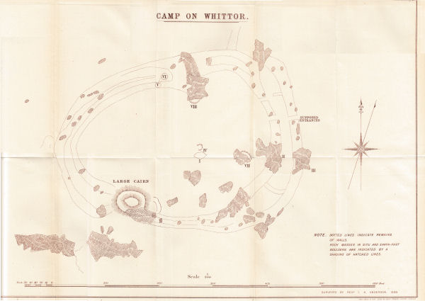
Plan by Rev K Anderson 1899 DEC Report 6
Database entries
PDW coverage: Dartmoor Site: White Tor Fort
OS Map: SX 5423 7867
OS Source: Constructed
HER: MDV4101
Megalithic Portal: 17506
Alternate name: White Tor (Whittor)
Short Name: NE White Tor
Butler map: 31.13
DPD page: 13
Exist: Yes
Record: Unique
Record Source: PDW
Hut Class: No
Lidar: SX 5423 7867
Guide Map: 24
Nearest Bus Stop: Merrivale Dartmoor Inn (4.7 km) [Route: 98,171(20/07/26 to 19/09/26)]
Nearby sites: SX 5423 7867
Notes
Neolithic tor enclosure. "A camp on the summit of White Tor formed by a double wall, now in ruinous condition. Both walls appear to have been 10 to 11 feet thick, the outer wall being 4 to 4 1/2 feet high, the inner 6 to 7 feet high. The distance between the walls varies between 10 and 40 feet. The entrances are to the east, where access is easier, they are not opposite and are protected by the spur walls. Within the camp are four hut circles and three possible hut shelters, and two northern circles (numbers 5 and 6 on plan) are joined by a short wall." See also, Legendary Dartmoor: Dartmoor's White Tor Neolithic Settlement. See also Dartmoor Tor Enclosures Project.References
These are selected references with an emphasis on out of copyright sources linked as PDFs. For more detailed references try any linked HER or PMD record above.
- Anderson, I. K. (Rev.), Eleventh Report of the Dartmoor Exploration Committee, T.D.A. Vol.38 pp.101-113 (1906)
- Baring-Gould, Sabine, Sixth Report of the Dartmoor Exploration Committee, T.D.A. Vol.31 pp.146-155 (1899)
- Baring-Gould, Sabine, A Book of Dartmoor, (2002)
- Basell L, Bray L, Webber H, Randall S, Crabb A, Dartmoor Tor Enclosures Survey, PAST newsletter of the Prehistoric Society No. 95 Summer 2020 (2020)
- Brailsford, J. W, Bronze Age Stone Monuments of Dartmoor, Antiquity Volume 12, Number 48 pp.444-63 (1938)
- Brent, Francis, Prehistoric Remains on Dartmoor, Journal of the British Archaeological Association Vol.39 pp.217-222 (1883)
- Burnard, Robert, Early Man, The Victoria History of the County of Devon: v. 1 (1906)
- Butler, Jeremy, Dartmoor Atlas of Antiquities, vol.2: The North, (1991)
- Lethbridge, William D., Discover Preshistoric Dartmoor, (2015)
- Newman, Phil, The Langstone Moor Stone Circle, Peter Tavy, Devon and its Prehistoric Environs, English Heritage (2003)
- Newman, Phil, Archaeological Sites within Merrivale Training Area, Southwest Landscape Investigations (2018)
- Pilkington-Rogers, C. W., The Date of the Dartmoor Antiquities, T.D.A. Vol.64 pp.379-388 (1932)
- Prowse, Arthur B., Notes on the Neighbourhood of White Tor, West Dartmoor, T.D.A. Vol.21 pp.166-170 (1889)
- Silvester, R., The Relationship of First Millennium Settlement to the Upland Areas of the South West., D.A.S.P. No.37 pp.178-179 (1979)