
Prehistoric sites within 3km of SX 74900 75250
Guidance for walkers: The monuments featured in this database are archaeological treasures and need to be protected and preserved - please do not disturb any sites. Please check access and firing times before visiting sites, not all sites listed are on open access land. Firing ranges and boundaries of open access areas are marked on the OL28 OS Dartmoor Explorer map. Please stick to the country code and consider giving support to the numerous agencies that help to keep Dartmoor a fabulous natural and historic environment!
About the database listings: In all listings clicking on the photo or the site name will open a page for the site with a larger photo and further details from the database. The database now has over 6680 records covering nearly all publicly listed sites on Dartmoor including around 4800 round houses. This level of detail is of interest to archaeologists but tends to swamp listings of sites more likely to be of interest for walkers. For this reason, the listings default to around 550 core sites only. These are the stone circles, stone rows and the ring cairns listed by Turner. The default search radius is 2 km. The controls below the map can be used to start a new search by entering a 6- or 8-digit reference (without the prefix "SX"). The search radius can be specified and you can add incremental Display layers of detail on top of the core sites. If using a more detailed layer you will need to decrease the search radius to avoid getting hundreds of search results.
- Core sites Default listing of core sites consisting of stone circles & rows and some of the major ring cairns.
- Plus cairns adds approx. 1000 cairns and other minor sites not included in the core listings but excluding round houses.
- Plus round houses adds approx. 4800 round houses.
- Plus non-sites adds in the records for sites that no longer exist or are not prehistoric sites.
- Plus duplicates adds records excluded as duplicates. Those maybe duplicate records in external listings (e.g. the Historic Environment Records). For example, some sites have been identified as cairns in some listings and interpreted as round houses in other listings and both records appear.
These listings have incorporated, matched up and merged all of the records from all of the major archaeological listings including: Worth, Grinsell, Turner, Butler, Bill Radcliffe, Sandy Gerrard, Megalithic Portal, the National Monument Records and the Historic Environment Records. The author would like to thank Bill, Sandy, the lovely people both at Megalithic Portal (especially Anne Tate who did an amazing job to link listings) and at ACE Archaeology for collaborative work over the years to synchronise and correct listings across the various websites which now interlink. A culmination of years of work the final merger of cairn records took 3 months of cross referencing in 2017 the result being a snapshot of the records at that time. This data has in turn been refined since by field work and research. The round house data was supplied by Sandy Gerrard. Grid references are in order of accuracy: from Google Earth satellite, if visible and found, from a Garmin GPS reading, if visited by the author and from the literature otherwise. Individual site pages will state the source of the grid reference and provide satellite imagery. If a site listing lacks a photo it has not yet been visited by the author in which case the grid reference is from the literature.
Currently the database only includes sites which can be represented by a grid reference. Reaves are not included as they require GIS shape technology which is beyond the current capability of this system. To see the sources for the records, look at the tables on the resources menu. The database listings can also be viewed on a Google map and downloaded as GPS datasets for Garmin devices.
Corrections, or any feedback or suggestions are very welcome, email: info@dartmoorwalks.org.uk.
NOTE: Clicking on the icons for each monument in the map will give the name of the site. You can zoom in and out and drag the map around.
List of sites within 3km of SX 74900 75250
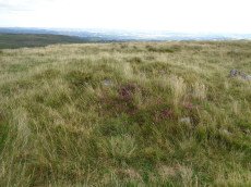
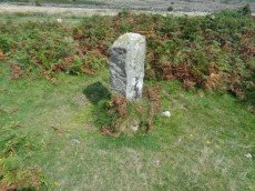
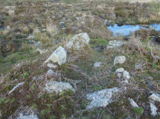
Rippon Tor 3 Reported Cist
OS Map: SX 74698 75537
HER: MDV7434
PMD: Rippon Tor Summit
ShortName: CN Rippon To3
Butler map: 5.5.3
Grinsell: ILS 2
Turner: A62
Notes: NMR Cairn 'B' at SX 7474 7547 has been considerably mutilated in the eastern quadrant where it is barely 0.5m. high; otherwise it is up to 3.0m. high. Butler states "Composed of small stones except for a large slab lying at the edge, this is probably the site of the cist referred to by Crossing as almost covered by turf, though he makes no mention of the cairn.
Nearby sites: SX 74698 75537
Distance: 0.35km
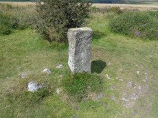
Rippon Tor 4 Cairn
OS Map: SX 74724 75501
HER: MDV13721
ShortName: CN Rippon To4
Butler map: 5.5.4
Grinsell: ILS 3
Notes: NMR B?
Nearby sites: SX 74724 75501
Distance: 0.31km
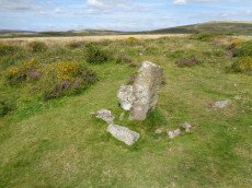
Rippon Tor 5 Cairn
OS Map: SX 74750 75479
HER: MDV7433
ShortName: CN Rippon To5
Butler map: 5.5.5
Grinsell: ILS 4
Notes: NMR A? "One of a pair of large cairns south-east of Rippon Tor. It is located on a reave but probably predates it. A much spread and turf-covered cairn of up to 25 metres diameter, 87 metres south-east of Rippon Tor outcrop".
Nearby sites: SX 74750 75479
Distance: 0.27km
Lower Horridge 1 Cairn
OS Map: SX 75505 75151
HER: MDV8100
ShortName: CN:Lower Hor1
Butler map: 5.6.1
Grinsell: ILS 7
Nearby sites: SX 75505 75151
Distance: 0.61km
Lower Horridge 2 Cairn
OS Map: SX 75527 75127
HER: MDV8101
ShortName: CN:Lower Hor2
Butler map: 5.6.2
Grinsell: ILS 8
Nearby sites: SX 75527 75127
Distance: 0.64km
Halsanger Clearance Cairn
OS Map: SX 7445 7522
HER: MDV7548
ShortName: CN:Halsanger1
Butler map: 5.7
Grinsell: ASH 1
Nearby sites: SX 7445 7522
Distance: 0.45km
Horridge Common 1 Reported Cairn
OS Map: SX 75722 74552
HER: MDV62331
ShortName: CN?Horridge 1
Butler map: 6.1
Notes: Butler refers to a cairn amongst the huts within the Horridge Common enclosed settlement. THE HER has this feature listed as a round house but the entry does mention Butler's description as a cairn. See also duplicate record for the round house entry SiteID=6686 (HER=62331)
Nearby sites: SX 75722 74552
Distance: 1.08km
Haytor Rocks Round House
OS Map: SX 75605 76985
HER: MDV26556
ShortName: HT:Haytor Ro1
Nearby sites: SX 75605 76985
Distance: 1.87km
Horridge Common 2 Cairn
OS Map: SX 75650 74950
HER: MDV8217
ShortName: CN:Horridge 2
Butler map: 6.3
Grinsell: ILS 9
Nearby sites: SX 75650 74950
Distance: 0.81km
Haytor Rocks Round House
OS Map: SX 7568 7719
HER: MDV26539
ShortName: HT:Haytor Ro2
Nearby sites: SX 7568 7719
Distance: 2.09km
Haytor Rocks Round House
OS Map: SX 75525 76985
HER: MDV26556
ShortName: HT:Haytor Ro3
Nearby sites: SX 75525 76985
Distance: 1.84km
Haytor Rocks Round House
OS Map: SX 75635 76995
HER: MDV26556
ShortName: HT:Haytor Ro4
Nearby sites: SX 75635 76995
Distance: 1.89km
Haytor Rocks NE Round House
OS Map: SX 7612 7748
HER: MDV26574
ShortName: HT:Haytor Ro5
Nearby sites: SX 7612 7748
Distance: 2.54km
Top Tor 2 Cairn
OS Map: SX 73545 76555
HER: MDV7457
ShortName: CN:Top Tor 21
Butler map: 9.7.2
Grinsell: WID 12
Notes: NMR A
Nearby sites: SX 73545 76555
Distance: 1.88km
Haytor Rocks NE Round House
OS Map: SX 7603 7733
HER: MDV26538
ShortName: HT:Haytor Ro6
Nearby sites: SX 7603 7733
Distance: 2.37km
Horridge Common Round House
OS Map: SX 7584 7488
HER: MDV62341
ShortName: HT:Horridge 1
Nearby sites: SX 7584 7488
Distance: 1.01km
Top Tor 3 Cairn Circle
OS Map: SX 73657 76472
HER: MDV7456
ShortName: CN:Top Tor 31
Butler map: 9.7.3
Butler Vol 5: p.46 & Fig.25
Barrow Report: 53
Notes: NMR B "One of a group of three, recognisable mainly by four large in situ boulders which represent the remains of a substantial retaining circle. However, much of the fabric has been removed leaving only a faint, roughly circular earthwork of 9.5 metres diameter."
Nearby sites: SX 73657 76472
Distance: 1.74km
Horridge Common Round House
OS Map: SX 75800 74419
ShortName: HT:Horridge 2
Nearby sites: SX 75800 74419
Distance: 1.22km
Buckland Common Round House
OS Map: SX 7387 7439
HER: MDV31014
ShortName: HT:Buckland 1
Nearby sites: SX 7387 7439
Distance: 1.34km
Horridge Common Round House
OS Map: SX 75769 74887
HER: MDV25838
ShortName: HT:Horridge 3
Nearby sites: SX 75769 74887
Distance: 0.94km
Saddle Tor Crop Mark
OS Map: SX 751 765
HER: MDV28309
ShortName: CNxSaddleTor2
Notes: Aerial Photograph
Nearby sites: SX 751 765
Distance: 1.27km
Buckland Common Round House
OS Map: SX 73699 73775
HER: MDV30626
ShortName: HT:Buckland 2
Nearby sites: SX 73699 73775
Distance: 1.90km
Horridge Common Round House
OS Map: SX 75660 74477
HER: MDV62333
ShortName: HT:Horridge 4
Nearby sites: SX 75660 74477
Distance: 1.08km
Wittaburrow 2 Reported Cairn
OS Map: SX 73358 75201
ShortName: CN?Wittaburr2
Butler map: 9.9.2
Notes: Butler: "A low mound of stones 5.0 m across and 0.3 m high, with a square pit at the centre lies 30 m to the south-east [of Wittaburrow]". Not listed on NMR or HER.
Nearby sites: SX 73358 75201
Distance: 1.54km
Buckland Common Round House
OS Map: SX 73716 74786
ShortName: HT:Buckland 3
Nearby sites: SX 73716 74786
Distance: 1.27km
Horridge Common Round House
OS Map: SX 75720 74582
HER: MDV62330
ShortName: HT:Horridge 5
Nearby sites: SX 75720 74582
Distance: 1.06km
Buckland Common Round House
OS Map: SX 7366 7443
HER: MDV8024
ShortName: HT:Buckland 4
Nearby sites: SX 7366 7443
Distance: 1.49km
Horridge Common Round House
OS Map: SX 7506 7494
HER: MDV62325
ShortName: HT:Horridge 6
Nearby sites: SX 7506 7494
Distance: 0.35km
Blackslade Ford 1 Reported Cairn
OS Map: SX 73701 75120
HER: MDV20169
ShortName: CN:Blackslad3
Butler map: 10.
Grinsell: WID 24
Nearby sites: SX 73701 75120
Distance: 1.21km
Buckland Common Round House
OS Map: SX 73656 74667
HER: MDV8039
ShortName: HT:Buckland 5
Nearby sites: SX 73656 74667
Distance: 1.37km
Horridge Common Round House
OS Map: SX 75673 74531
HER: MDV62332
ShortName: HT:Horridge 7
Nearby sites: SX 75673 74531
Distance: 1.06km
Blackslade Ford 2 Reported Cairn
OS Map: SX 73630 75197
HER: MDV7534
ShortName: CN:Blackslad4
Butler map: 10.7
Butler Vol 5: p.54 & Fig.31
Nearby sites: SX 73630 75197
Distance: 1.27km
Buckland Common Round House
OS Map: SX 73536 73997
HER: MDV31020
ShortName: HT:Buckland 6
Nearby sites: SX 73536 73997
Distance: 1.85km
Horridge Common Round House
OS Map: SX 75686 74472
HER: MDV62334
ShortName: HT:Horridge 8
Nearby sites: SX 75686 74472
Distance: 1.11km
Blackslade Ford 3 Cairn
OS Map: SX 7379 7498
HER: MDV30638
ShortName: CN:Blackslad5
Butler map: 10.
Nearby sites: SX 7379 7498
Distance: 1.14km
Pudsham Down Reported Cairn
OS Map: SX 7327 7485
HER: MDV31062
ShortName: CN?PudshamDown
Nearby sites: SX 7327 7485
Distance: 1.68km
Buckland Common Round House
OS Map: SX 73454 73929
HER: MDV7995
ShortName: HT:Buckland 7
Nearby sites: SX 73454 73929
Distance: 1.96km
Horridge Common Round House
OS Map: SX 75714 74610
HER: MDV62329
ShortName: HT:Horridge 9
Nearby sites: SX 75714 74610
Distance: 1.04km
Blackslade Ford 4 Cairn
OS Map: SX 73827 74872
HER: MDV30634
ShortName: CN Blackslad6
Butler map: 10.
Nearby sites: SX 73827 74872
Distance: 1.14km
Buckland Common Round House
OS Map: SX 73447 73831
HER: MDV7995
ShortName: HT:Buckland 8
Nearby sites: SX 73447 73831
Distance: 2.03km
Horridge Common Round House
OS Map: SX 75689 74350
HER: MDV62335
ShortName: HT:Horridge 10
Nearby sites: SX 75689 74350
Distance: 1.20km
Cold Cross East Reported Cairn
OS Map: SX 73999 74292
HER: MDV30642
ShortName: CN Cold Cros1
Butler map: 10.
Butler Vol 5: p.54 & Fig.32
Nearby sites: SX 73999 74292
Distance: 1.32km
Buckland Common Round House
OS Map: SX 73442 73748
HER: MDV7995
ShortName: HT:Buckland 9
Nearby sites: SX 73442 73748
Distance: 2.09km
Horridge Common Round House
OS Map: SX 75693 74329
HER: MDV62336
ShortName: HT:Horridge 11
Nearby sites: SX 75693 74329
Distance: 1.22km
Buckland Common 1 Reported Cairn
OS Map: SX 73772 73930
ShortName: CN-Buckland 2
Butler map: 10.
Notes: Linear arrangement of mounds incorporated into boundary. Could be prehistoric cairns.
Nearby sites: SX 73772 73930
Distance: 1.74km
Buckland Common Round House
OS Map: SX 73432 73867
HER: MDV7995
ShortName: HT:Buckland 10
Nearby sites: SX 73432 73867
Distance: 2.02km
Horridge Common Round House
OS Map: SX 75707 74622
HER: MDV62328
ShortName: HT:Horridge 12
Nearby sites: SX 75707 74622
Distance: 1.02km
Buckland Common 2 Reported Cairn
OS Map: SX 73742 73865
HER: MDV30646
ShortName: CN Buckland 3
Butler map: 10.
Notes: HER: "A flattened and spread round cairn straddles the parish boundary between Buckland and Ashburton. A boundary stone is set into the cairn."
Nearby sites: SX 73742 73865
Distance: 1.81km
Buckland Common Round House
OS Map: SX 73392 73880
HER: MDV7995
ShortName: HT:Buckland 11
Nearby sites: SX 73392 73880
Distance: 2.04km
Horridge Common Round House
OS Map: SX 75708 74347
HER: MDV62337
ShortName: HT:Horridge 13
Nearby sites: SX 75708 74347
Distance: 1.21km
Buckland Common 3 Reported Cairn
OS Map: SX 73588 73559
ShortName: CN?Buckland 4
Butler map: 10.8
Notes: Linear arrangement of mounds incorporated into boundary. Could be prehistoric cairns.
Nearby sites: SX 73588 73559
Distance: 2.14km
Buckland Common Round House
OS Map: SX 73483 74146
HER: MDV8017
ShortName: HT:Buckland 12
Nearby sites: SX 73483 74146
Distance: 1.80km
Horridge Common Round House
OS Map: SX 75156 75261
HER: MDV62326
ShortName: HT:Horridge 14
Nearby sites: SX 75156 75261
Distance: 0.26km
Buckland Common 4 Reported Cairn
OS Map: SX 73587 73556
ShortName: CN?Buckland 5
Butler map: 10.8
Notes: Linear arrangement of mounds incorporated into boundary. Could be prehistoric cairns.
Nearby sites: SX 73587 73556
Distance: 2.14km
Horridge Common Round House
OS Map: SX 75767 74870
HER: MDV62327
ShortName: HT:Horridge 15
Nearby sites: SX 75767 74870
Distance: 0.95km
Horridge Common Round House
OS Map: SX 7586 7454
HER: MDV62340
ShortName: HT:Horridge 16
Nearby sites: SX 7586 7454
Distance: 1.19km
Rushlade Common Round House
OS Map: SX 74245 73555
HER: MDV25176
ShortName: HT:Rushlade 1
Nearby sites: SX 74245 73555
Distance: 1.82km
Buckland Beacon Cairn
OS Map: SX 73510 73118
HER: MDV7977
ShortName: CN Buckland 1
Butler map: 10.
Grinsell: B:BITM 1
Nearby sites: SX 73510 73118
Distance: 2.55km
Horridge Common Round House
OS Map: SX 75721 74230
HER: MDV62339
ShortName: HT:Horridge 17
Nearby sites: SX 75721 74230
Distance: 1.31km
Rushlade Common Round House
OS Map: SX 74335 73555
HER: MDV25176
ShortName: HT:Rushlade 2
Nearby sites: SX 74335 73555
Distance: 1.79km
Horridge Common Round House
OS Map: SX 75723 74360
HER: MDV62338
ShortName: HT:Horridge 18
Nearby sites: SX 75723 74360
Distance: 1.21km
Horridge Common Round House
OS Map: SX 75362 74602
HER: MDV8215
ShortName: HT:Horridge 19
Nearby sites: SX 75362 74602
Distance: 0.80km
Horridge Common Round House
OS Map: SX 75720 74549
HER: MDV62331
ShortName: HT:Horridge 20
Notes: Butler refers to a cairn amongst the huts within the Horridge Common enclosed settlement. THE HER has this feature listed as a round house but the entry does mention Butler's description as a cairn. This record is being marked as a duplicate of the cairn SiteID=1030 (HER=62331).
Nearby sites: SX 75720 74549
Distance: 1.08km
RipponTor E of Summit Reported Cairn
OS Map: SX 7468 7553
HER: MDV-1
PMD: Rippon Tor E.
ShortName: CT?RipponTor1
Notes: PMD: Probable dupl;icate of HER 7434 "Stone setting round a possible central cist. 2.3m x 3.5m N-S. Very slight retaining bank 6.5m dia. Ring bank now under reave. Probably the same as SX 7468 7553."
Nearby sites: SX 7468 7553
Distance: 0.36km
Saddle Tor E Round House
OS Map: SX 75573 76337
HER: MDV115985
ShortName: HT:Saddle To1
Nearby sites: SX 75573 76337
Distance: 1.28km
Saddle Tor E Round House
OS Map: SX 75565 76325
HER: MDV115987
ShortName: HT:Saddle To2
Nearby sites: SX 75565 76325
Distance: 1.26km
Saddle Tor E Round House
OS Map: SX 75698 76382
HER: MDV8097
ShortName: HT:Saddle To3
Nearby sites: SX 75698 76382
Distance: 1.39km
Saddle Tor E Round House
OS Map: SX 75711 76399
HER: MDV8098
ShortName: HT:Saddle To4
Nearby sites: SX 75711 76399
Distance: 1.41km
Buckland Ridge (N) Cairn
OS Map: SX 73579 73510
HER: MDV30631
ShortName: CN:Buckland 9
Turner: A47
Nearby sites: SX 73579 73510
Distance: 2.18km
Rippon Tor N Round House
OS Map: SX 74846 75809
HER: MDV7555
ShortName: HT:Rippon To1
Nearby sites: SX 74846 75809
Distance: 0.56km
Rippon Tor N Round House
OS Map: SX 74900 75745
HER: MDV7555
ShortName: HT:Rippon To2
Nearby sites: SX 74900 75745
Distance: 0.50km
Rippon Tor N Round House
OS Map: SX 74887 75798
HER: MDV7555
ShortName: HT:Rippon To3
Nearby sites: SX 74887 75798
Distance: 0.55km
Rippon Tor N Round House
OS Map: SX 74693 75727
HER: MDV62356
ShortName: HT:Rippon To4
Nearby sites: SX 74693 75727
Distance: 0.52km
Rippon Tor N Round House
OS Map: SX 74902 75769
HER: MDV7555
ShortName: HT:Rippon To5
Nearby sites: SX 74902 75769
Distance: 0.52km
Rippon Tor N Round House
OS Map: SX 74697 75747
HER: MDV62355
ShortName: HT:Rippon To6
Nearby sites: SX 74697 75747
Distance: 0.54km
Rippon Tor W Round House
OS Map: SX 74429 75587
HER: MDV62354
ShortName: HT:Rippon To7
Nearby sites: SX 74429 75587
Distance: 0.58km
Rippon Tor W Round House
OS Map: SX 74411 75587
HER: MDV62353
ShortName: HT:Rippon To8
Nearby sites: SX 74411 75587
Distance: 0.59km
Pinchaford Round House
OS Map: SX 76855 76285
HER: MDV26625
ShortName: HT:Pinchafor1
Nearby sites: SX 76855 76285
Distance: 2.21km
Pinchaford Round House
OS Map: SX 76835 76375
HER: MDV26625
ShortName: HT:Pinchafor2
Nearby sites: SX 76835 76375
Distance: 2.24km
Halshanger Common Round House
OS Map: SX 74471 74705
HER: MDV62311
ShortName: HT:Halshange1
Nearby sites: SX 74471 74705
Distance: 0.69km
Pudsham Down Round House
OS Map: SX 73432 74728
HER: MDV113188
ShortName: HT:Pudsham D1
Nearby sites: SX 73432 74728
Distance: 1.56km
Halshanger Common Round House
OS Map: SX 74568 74538
HER: MDV62348
ShortName: HT:Halshange2
Nearby sites: SX 74568 74538
Distance: 0.79km
Halshanger Common Round House
OS Map: SX 74717 74768
HER: MDV62318
ShortName: HT:Halshange3
Nearby sites: SX 74717 74768
Distance: 0.52km
Halshanger Common Round House
OS Map: SX 7456 7451
HER: MDV62313
ShortName: HT:Halshange4
Nearby sites: SX 7456 7451
Distance: 0.81km
Halshanger Common Round House
OS Map: SX 74548 74744
HER: MDV62314
ShortName: HT:Halshange5
Nearby sites: SX 74548 74744
Distance: 0.62km
Buckland Down Reported Cist
OS Map: SX 735 740
HER: MDV-1
PMD: Buckland Down
ShortName: CT?Buckland 7
Notes: Butler Vol 1 p.115. One burial mound awaiting rediscovery is the cairncircle surrounding a cist on 'Buckland Down' mentioned in Note 43 to Carrington's poem on Dartmoor.
Nearby sites: SX 735 740
Distance: 1.88km
Halshanger Common Round House
OS Map: SX 74547 74668
HER: MDV62312
ShortName: HT:Halshange6
Nearby sites: SX 74547 74668
Distance: 0.68km
Halshanger Common Round House
OS Map: SX 74578 74728
HER: MDV62315
ShortName: HT:Halshange7
Nearby sites: SX 74578 74728
Distance: 0.61km
Halshanger Common Round House
OS Map: SX 7430 7476
HER: MDV62310
ShortName: HT:Halshange8
Nearby sites: SX 7430 7476
Distance: 0.77km
Halshanger Common Round House
OS Map: SX 74791 74758
HER: MDV62319
ShortName: HT:Halshange9
Nearby sites: SX 74791 74758
Distance: 0.50km
Emsworthy Round House
OS Map: SX 7466 7656
HER: MDV26838
ShortName: HT:Emsworthy1
Nearby sites: SX 7466 7656
Distance: 1.33km
Halshanger Common Round House
OS Map: SX 7428 7474
HER: MDV62308
ShortName: HT:Halshange10
Nearby sites: SX 7428 7474
Distance: 0.80km
Emsworthy Round House
OS Map: SX 7478 7680
HER: MDV26842
ShortName: HT:Emsworthy2
Nearby sites: SX 7478 7680
Distance: 1.55km
Halshanger Common Round House
OS Map: SX 74864 74860
HER: MDV62320
ShortName: HT:Halshange11
Nearby sites: SX 74864 74860
Distance: 0.39km
Halshanger Common Round House
OS Map: SX 74959 74894
HER: MDV62322
ShortName: HT:Halshange12
Nearby sites: SX 74959 74894
Distance: 0.36km
Halshanger Common Round House
OS Map: SX 75049 74815
HER: MDV8174
ShortName: HT:Halshange13
Nearby sites: SX 75049 74815
Distance: 0.46km
Halshanger Common Round House
OS Map: SX 75049 74853
HER: MDV8173
ShortName: HT:Halshange14
Nearby sites: SX 75049 74853
Distance: 0.42km
Bonehill Down Round House
OS Map: SX 73124 77019
HER: MDV7554
ShortName: HT:Bonehill 1
Nearby sites: SX 73124 77019
Distance: 2.51km
Bonehill Down Round House
OS Map: SX 73147 77005
HER: MDV26955
ShortName: HT:Bonehill 2
Nearby sites: SX 73147 77005
Distance: 2.48km
Hollow Tor N Round House
OS Map: SX 72977 76696
HER: MDV7424
ShortName: HT:Hollow To1
Nearby sites: SX 72977 76696
Distance: 2.41km
Hollow Tor N Round House
OS Map: SX 73185 76435
HER: MDV113193
ShortName: HT:Hollow To2
Nearby sites: SX 73185 76435
Distance: 2.08km
Hollow Tor N Round House
OS Map: SX 73193 76428
HER: MDV113193
ShortName: HT:Hollow To3
Nearby sites: SX 73193 76428
Distance: 2.07km
Hollow Tor N Round House
OS Map: SX 72995 76689
HER: MDV7424
ShortName: HT:Hollow To4
Nearby sites: SX 72995 76689
Distance: 2.39km
Hollow Tor N Round House
OS Map: SX 73042 76500
ShortName: HT:Hollow To5
Nearby sites: SX 73042 76500
Distance: 2.24km
Hollow Tor W Round House
OS Map: SX 72960 76194
HER: MDV26826
ShortName: HT:Hollow To6
Nearby sites: SX 72960 76194
Distance: 2.16km
Hay Tor S.E.4 Cairn
OS Map: SX 76030 76598
HER: MDV103589
ShortName: CN:Hay Tor 4
Notes: A badly robbed out cairn on the southern ridge of Haytor Down - one of a group of four.
Nearby sites: SX 76030 76598
Distance: 1.76km
Hollow Tor W Round House
OS Map: SX 73028 76261
HER: MDV26826
ShortName: HT:Hollow To7
Nearby sites: SX 73028 76261
Distance: 2.13km
Hay Tor S.E.3 Cairn
OS Map: SX 76098 76550
HER: MDV103590
ShortName: CN:Hay Tor 3
Notes: "A badly disturbed Prehistoric cairn on the southern ridge of Haytor Down - one of a group of four."
Nearby sites: SX 76098 76550
Distance: 1.77km
Hay Tor S.E.2 Cairn
OS Map: SX 76181 76543
HER: MDV103591
ShortName: CN:Hay Tor 2
Notes: Prehistoric cairn which has been badly disturbed and robbed lies on the southern ridge of Haytor Down - one of a group of four
Nearby sites: SX 76181 76543
Distance: 1.82km
Hemsworthy Gate (E of ) Reported Cairn
OS Map: SX 7457 7612
HER: MDV26840
ShortName: CN?Hemsworthy
Grinsell: B:ILS 4a
Notes: Shaft of C19 tin mine, on some maps as cairn. T. Greeves
Nearby sites: SX 7457 7612
Distance: 0.93km
Foale's Arrishes Round House
OS Map: SX 73790 75856
HER: MDV7417
ShortName: HT:Foale's A1
Nearby sites: SX 73790 75856
Distance: 1.26km
Foale's Arrishes Round House
OS Map: SX 73578 75802
HER: MDV21488
ShortName: HT:Foale's A2
Nearby sites: SX 73578 75802
Distance: 1.43km
Foale's Arrishes Round House
OS Map: SX 73581 75785
HER: MDV21493
ShortName: HT:Foale's A3
Nearby sites: SX 73581 75785
Distance: 1.42km
Foale's Arrishes Round House
OS Map: SX 73750 75858
HER: MDV7416
ShortName: HT:Foale's A4
Nearby sites: SX 73750 75858
Distance: 1.30km
Welstor Round House
OS Map: SX 74574 73274
HER: MDV8027
ShortName: HT:Welstor1
Nearby sites: SX 74574 73274
Distance: 2.00km
Foale's Arrishes Round House
OS Map: SX 73763 76108
HER: MDV21491
ShortName: HT:Foale's A5
Nearby sites: SX 73763 76108
Distance: 1.42km
Welstor Round House
OS Map: SX 74005 73415
HER: MDV25185
ShortName: HT:Welstor2
Nearby sites: SX 74005 73415
Distance: 2.04km
Foale's Arrishes Round House
OS Map: SX 73790 76028
HER: MDV21489
ShortName: HT:Foale's A6
Nearby sites: SX 73790 76028
Distance: 1.36km
Welstor Round House
OS Map: SX 740 734
HER: MDV25185
ShortName: HT:Welstor3
Nearby sites: SX 740 734
Distance: 2.06km
Foale's Arrishes Round House
OS Map: SX 73803 75995
HER: MDV21490
ShortName: HT:Foale's A7
Nearby sites: SX 73803 75995
Distance: 1.33km
Foale's Arrishes Round House
OS Map: SX 73758 75951
HER: MDV7419
ShortName: HT:Foale's A8
Nearby sites: SX 73758 75951
Distance: 1.34km
Foale's Arrishes Round House
OS Map: SX 73762 75956
HER: MDV7419
ShortName: HT:Foale's A9
Nearby sites: SX 73762 75956
Distance: 1.34km
Bagtor Round House
OS Map: SX 76005 75395
HER: MDV62351
ShortName: HT:Bagtor1
Nearby sites: SX 76005 75395
Distance: 1.11km
Bagtor Round House
OS Map: SX 75895 75335
HER: MDV26534
ShortName: HT:Bagtor2
Nearby sites: SX 75895 75335
Distance: 1.00km
Tunhill Rocks Round House
OS Map: SX 73190 75806
HER: MDV43229
ShortName: HT:Tunhill R1
Nearby sites: SX 73190 75806
Distance: 1.80km
Bagtor Round House
OS Map: SX 75965 75355
ShortName: HT:Bagtor3
Nearby sites: SX 75965 75355
Distance: 1.07km
Tunhill Rocks Round House
OS Map: SX 73197 75795
HER: MDV43228
ShortName: HT:Tunhill R2
Nearby sites: SX 73197 75795
Distance: 1.79km
Bagtor Down Round House
OS Map: SX 75181 75734
HER: MDV8052
ShortName: HT:Bagtor Do1
Nearby sites: SX 75181 75734
Distance: 0.56km
Bagtor Down Round House
OS Map: SX 74973 75882
ShortName: HT:Bagtor Do2
Nearby sites: SX 74973 75882
Distance: 0.64km
Bagtor Down Round House
OS Map: SX 74968 75880
ShortName: HT:Bagtor Do3
Nearby sites: SX 74968 75880
Distance: 0.63km
Bagtor Down Round House
OS Map: SX 75191 75716
HER: MDV8052
ShortName: HT:Bagtor Do4
Nearby sites: SX 75191 75716
Distance: 0.55km
Chittleford Hill Reported Cairn
OS Map: SX 725 754
HER: MDV7469
ShortName: CN:Chittlefo1
Notes: Possible site of a Neolithic barrow found in the field walls by the roadside near the top of Chittleford Hill. A very large orthostat, or shiner (sic), standing here which may have been a capstone. Nearby fields called "Shelstone Lay" point to the existence of a cromlech. Also the walls of the field contain a large number of very large slabs and pillar-like stones such as might have formed a megalthic tomb.
Nearby sites: SX 725 754
Distance: 2.40km
Holwell Round House
OS Map: SX 7404 7708
HER: MDV7532
ShortName: HT:Holwell1
Nearby sites: SX 7404 7708
Distance: 2.02km
Holwell E Round House
OS Map: SX 74714 77054
HER: MDV7530
ShortName: HT:Holwell E1
Nearby sites: SX 74714 77054
Distance: 1.81km
Holwell E Round House
OS Map: SX 74745 77118
HER: MDV116220
ShortName: HT:Holwell E2
Nearby sites: SX 74745 77118
Distance: 1.87km
Holwell E Round House
OS Map: SX 74849 77489
HER: MDV7402
ShortName: HT:Holwell E3
Nearby sites: SX 74849 77489
Distance: 2.24km
Holwell E Round House
OS Map: SX 74719 77074
HER: MDV7531
ShortName: HT:Holwell E4
Nearby sites: SX 74719 77074
Distance: 1.83km
Holwell E Round House
OS Map: SX 74879 77441
HER: MDV7403
ShortName: HT:Holwell E5
Nearby sites: SX 74879 77441
Distance: 2.19km
Hay Tor S.E.5 Cairn
OS Map: SX 76861 75925
HER: MDV19471
ShortName: CN:Hay Tor 5
Nearby sites: SX 76861 75925
Distance: 2.07km
Holwell E Round House
OS Map: SX 74834 77571
HER: MDV26944
ShortName: HT:Holwell E6
Nearby sites: SX 74834 77571
Distance: 2.32km
Holwell E Round House
OS Map: SX 74851 77526
HER: MDV7401
ShortName: HT:Holwell E7
Nearby sites: SX 74851 77526
Distance: 2.28km
Holwell E Round House
OS Map: SX 74751 77100
HER: MDV116217
ShortName: HT:Holwell E8
Nearby sites: SX 74751 77100
Distance: 1.86km
Hayter S. Cairn
OS Map: SX 75631 76810
HER: MDV40740
ShortName: CN:Hayter S.1
Butler map: 1.8
Nearby sites: SX 75631 76810
Distance: 1.72km
Holwell E Round House
OS Map: SX 74719 77182
HER: MDV116223
ShortName: HT:Holwell E9
Nearby sites: SX 74719 77182
Distance: 1.94km
Emsworthy Rocks E.1 Cairn
OS Map: SX 7528 7682
HER: MDV78669
ShortName: CN:Emsworthy1
Butler map: 1.9.1
Notes: HER refers to two cairns
Nearby sites: SX 7528 7682
Distance: 1.62km
Holwell Lawn Round House
OS Map: SX 7404 7800
HER: MDV7533
ShortName: HT:Holwell L1
Nearby sites: SX 7404 7800
Distance: 2.88km
Emsworthy Rocks E.2 Cairn
OS Map: SX 7533 7684
HER: MDV78669
ShortName: CN:Emsworthy2
Butler map: 1.9.2
Notes: HER refers to two cairns
Nearby sites: SX 7533 7684
Distance: 1.65km
Holwell Tor Round House
OS Map: SX 753 775
ShortName: HT:Holwell T1
Nearby sites: SX 753 775
Distance: 2.29km
West Emsworthy Quarry Cairn
OS Map: SX 75784 77745
HER: MDV78602
ShortName: CN:West Emsw1
Butler map: 1.10
Nearby sites: SX 75784 77745
Distance: 2.65km
Holwell Tor Round House
OS Map: SX 75399 77609
HER: MDV8091
ShortName: HT:Holwell T2
Nearby sites: SX 75399 77609
Distance: 2.41km
Haytor Chambered Tomb
OS Map: SX 75766 76409
HER: MDV61778
ShortName: CN Haytor Ch1
Butler map: 1.f
Butler Vol 5: p.158 & Fig.97
Notes: Haytor chambered tomb to the west of the Haytor track. Circular mound circa 4 metres diameter surrounds a rectangular chamber, circa 3 metres by 1.4 metres, tapering slightly towards one end, partially filled with soil. One of pair of larger slabs at entrance on downhill edge of mound has collapsed inwards, the other stands c irca 1 metre above interior. Most of slabs forming sides of chamber appear in place but capstones have been removed. Entrance oriented south of east.
Nearby sites: SX 75766 76409
Distance: 1.45km
Holwell Tor N Round House
OS Map: SX 75332 77834
HER: MDV8089
ShortName: HT:Holwell T3
Nearby sites: SX 75332 77834
Distance: 2.62km
Holwell Tor N Round House
OS Map: SX 75284 77805
HER: MDV115871
ShortName: HT:Holwell T4
Nearby sites: SX 75284 77805
Distance: 2.58km
Holwell Tor N Round House
OS Map: SX 75408 77757
HER: MDV8090
ShortName: HT:Holwell T5
Nearby sites: SX 75408 77757
Distance: 2.56km
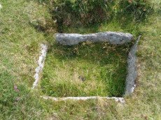
Blackslade Ford (culvert) Reported Cist
OS Map: SX 7372 7506
HER: MDV22823
PMD: Blackslade Ford
ShortName: CNxBlackslad2
Notes: Site of cist reported to Greeves by D. Brewer in 1984 (SX7372 7506). Visited 13/2/1984. Thought to be a culvert. Features lies immediately on the north-east side of the track to Tunhill from near Cold East Cross. It lies a little east of south from a bound stone marked EPB 1837 and about 70 paces from the bound stone.
Nearby sites: SX 7372 7506
Distance: 1.20km
Hay Tor S.E.6 Reported Cairn
OS Map: SX 7745 7630
HER: MDV26588
ShortName: CNxHay Tor 6
Nearby sites: SX 7745 7630
Distance: 2.76km
Bagtor Wood Reported Cairn
OS Map: SX 75830 74967
HER: MDV62344
ShortName: CN?Bagtor Wo1
Butler map: 4.3
Butler Vol 5: p.202 & Fig.146
Notes: Ruined hut or cairn at the centre of ovoid enclosure. Was obscured by vegetation at the time of the survey.
Nearby sites: SX 75830 74967
Distance: 0.97km
Hay Tor S.E.1 Cairn
OS Map: SX 76265 76521
HER: MDV103592
ShortName: CN:Hay Tor 1
Butler map: 4.4
Notes: A once substantial cairn of 22 metres diameter. The fabric has been heavily robbed though traces of a kerb survive.
Nearby sites: SX 76265 76521
Distance: 1.87km
Rippon Tor 2 Cairn
OS Map: SX 74685 75577
HER: MDV51161
ShortName: CN:Rippon To2
Butler map: 5.5.2
Notes: NMR C "Small cairn south of Rippon Tor cairn and immediately contiguous to scatter from it. Diam 4.0 metres, height 0.45 metres." Grid reference given here is to a small structure circa 6 metres in diameter visible in Google Earth - this might be this cairn but it is not certain.
Nearby sites: SX 74685 75577
Distance: 0.39km
Blackslade Down Cist
OS Map: SX 73416 75519
HER: MDV7437
Megalithic Portal: 32071
PMD: Blackslade Down
ShortName: CT Blackslade
Butler map: 9.8
Butler Vol 5: p.47 & Fig.26
DPD page: 129
Grinsell: WID 14
Barrow Report: 53 56
Notes: Butler Vol. 1. Map 9.8 (photo on p.61, diagram Vol. 5. p.47). Lethbridge diagram p.129 and photo bottom p.129.
Nearby sites: SX 73416 75519
Distance: 1.51km
Buckland Beacon Ancient Pool
OS Map: SX 73558 73260
HER: MDV127202
ShortName: PO:Buckland
Notes: "A pool measuring 10.5 by 9.5m. One of over 40 such 'sacred' pools identified on Dartmoor that are thought to have potentially been designed during the prehistoric period. Lies near a cairn." NB. Nearby is Turner A13 ring cairn.
Nearby sites: SX 73558 73260
Distance: 2.40km
Buckland Ridge (S) Stone Ring Cairn Circle
OS Map: SX 7357 7324
HER: MDV30630
Megalithic Portal: 45827
Alternate name: Buckland Common 5 Stone Ring Cairn Circle
ShortName: RC:BucklandRid
Butler map: 10.9
Turner: A13
Notes: Linear arrangement of mounds incorporated into boundary. Could be prehistoric cairns. Turner A13. No NMR record. "Robbed cairn. Stone ring is 13m inside diameter bank 1.80m wide and 50cms high, much of the bank on the eastern side has been destroyed. The central area has been disturbed, modern stone wall running north to south through the eastern section of the stone ring."
Nearby sites: SX 7357 7324
Distance: 2.41km
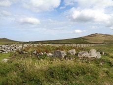
Foales Arrishes Settlement
OS Map: SX 737 758
HER: MDV7415
Megalithic Portal: 4623
ShortName: ST:FoalesArris
Nearby sites: SX 737 758
Distance: 1.32km
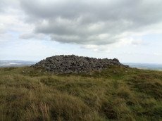
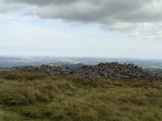
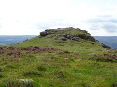
Rippon Tor Stone Ring Cairn Circle
OS Map: SX 74664 75581
HER: MDV7539
Megalithic Portal: 17833
PMD: Rippon Tor Summit
Alternate name: Rippon Tor 1 Stone Ring Cairn Circle
ShortName: RC Rippon Tor
Butler map: 5.5.1
Grinsell: ILS 1
Notes: "Cairn built around tor. Diameter 25 metres, height 4.0 metres." "Ring cairn, internal diameter 4.5 metres, with bank 1.0 metre wide and 0.4 metres high. In the centre is a boulder 3.0 metres wide, 2.0 metres thick, 2.5 metres high." NMR D
Nearby sites: SX 74664 75581
Distance: 0.41km
Saddle Tor Reported Cairn
OS Map: SX 75154 76343
ShortName: CN?SaddleTor1
Notes: This site was asked about by Max Piper on a Dartmoor Facebook group on 20 Nov 2020. Max observed: "atop Saddle Tor's eastern mass at SX 75154 76343, and at the very, very top. It appears to have utilised bedrock and is almost a ring cairn on the western side where broken rocks have been piled up." In the discussion that followed the consensus was that there had once been a flag pole sited here and that is the origin of this man-made mound. It is being added here as a "reported cairn" to help others trying to make sense of it. Thanks to Max for the grid reference and details. There are no entries on the HER for this feature.
Nearby sites: SX 75154 76343
Distance: 1.12km
Saddle Tor A Ancient Pool
OS Map: SX 75135 76534
HER: MDV127219
ShortName: PO:SaddleTorA
Notes: "A pool measuring 20m. One of over 40 such 'sacred' pools identified on Dartmoor that are thought to have potentially been designed during the prehistoric period. One of a group of three pools north-east of saddle Tor."
Nearby sites: SX 75135 76534
Distance: 1.31km
Saddle Tor B Ancient Pool
OS Map: SX 75172 76553
HER: MDV127220
ShortName: PO:SaddleTorB
Notes: "A pool measuring 16.5 by 14.5m. One of over 40 such 'sacred' pools identified on Dartmoor that are thought to have potentially been designed during the prehistoric period. One of a group of three pools north-east of saddle Tor."
Nearby sites: SX 75172 76553
Distance: 1.33km
Saddle Tor C Ancient Pool
OS Map: SX 75273 76526
HER: MDV127222
ShortName: PO:SaddleTorC
Notes: "A pool measuring 14 by 10m. One of over 40 such 'sacred' pools identified on Dartmoor that are thought to have potentially been designed during the prehistoric period. One of a group of three pools north-east of saddle Tor."
Nearby sites: SX 75273 76526
Distance: 1.33km
Seven Lords' Lands Encircled Cairn
OS Map: SX 74127 76237
HER: MDV7396
Megalithic Portal: 3454
PMD: Seven Lord's Lands
Alternate name: Sevon Lords Lands Encircled Cairn
ShortName: EC 7LordsLands
Butler map: 9.10
Butler Vol 5: p.51 & Fig.29
Grinsell: WID 13
Turner: F1
Barrow Report: 53
Notes: A cairn from 0.8m. to 1.2m. high, with a minor central excavation 0.5m. deep. The kerb retaining circle extends round the west and north quadrants.
Nearby sites: SX 74127 76237
Distance: 1.25km
Top Tor Cairn
OS Map: SX 73574 76472
HER: MDV7455
Megalithic Portal: 32049
Alternate name: Top Tor 1 Cairn
ShortName: CN:Top Tor
Butler map: 9.7.1
Grinsell: WID 11
Notes: NMR C. "Cairns on Top Tor. Two inconspicuous cairns lie about 80 metres apart beside the track which follows the crest of the ridge on the north side of Top Tor. The cairn to the south is smaller at circa 7.5 metres diameter by 0.2 metres high and has a circle of ten slabs showing above the turf around the edge. This cairn has been reported to have a stone row running downhill to the north but the few earthfast slabs in this direction are no more numerous than elsewhere on the hillside and this seems unconvincing. Nearly 100 metres east of the southern cairn is an arc of three standing and two flat slabs representing about a quarter of a circle. The interior is quite flat except for a shallow trench but possibly the stones originally surrounded a cairn which has been completely removed. Other details: Map 9, Site 7."
Nearby sites: SX 73574 76472
Distance: 1.80km
Tunhill Rocks Settlement
OS Map: SX 732 758
HER: MDV7438
Megalithic Portal: 31984
ShortName: ST:TunhillRock
Nearby sites: SX 732 758
Distance: 1.79km
Wittaburrow Cairn
OS Map: SX 73353 75214
HER: MDV7537
Megalithic Portal: 32069
ShortName: CN:Wittaburrow
Butler map: 9.9.1
Grinsell: WID 15
Notes: "A large stony round cairn, south of Wittaburrow. The mound has a 25 metre diameter at base, but the structure has been much altered, probably robbed, and is now quite low in places. A ‘bite-shaped’ section is missing from the main mound on the south-eastern side where a smaller cairn, which is unlikely to be an original feature, stands within the original spread of the monument. Two large hollows have been dug into the main mound which, overall, survives in a very uneven state."
Nearby sites: SX 73353 75214
Distance: 1.55km