
Prehistoric sites within 3km of SX 72000 71750
Guidance for walkers: The monuments featured in this database are archaeological treasures and need to be protected and preserved - please do not disturb any sites. Please check access and firing times before visiting sites, not all sites listed are on open access land. Firing ranges and boundaries of open access areas are marked on the OL28 OS Dartmoor Explorer map. Please stick to the country code and consider giving support to the numerous agencies that help to keep Dartmoor a fabulous natural and historic environment!
About the database listings: In all listings clicking on the photo or the site name will open a page for the site with a larger photo and further details from the database. The database now has over 6680 records covering nearly all publicly listed sites on Dartmoor including around 4800 round houses. This level of detail is of interest to archaeologists but tends to swamp listings of sites more likely to be of interest for walkers. For this reason, the listings default to around 550 core sites only. These are the stone circles, stone rows and the ring cairns listed by Turner. The default search radius is 2 km. The controls below the map can be used to start a new search by entering a 6- or 8-digit reference (without the prefix "SX"). The search radius can be specified and you can add incremental Display layers of detail on top of the core sites. If using a more detailed layer you will need to decrease the search radius to avoid getting hundreds of search results.
- Core sites Default listing of core sites consisting of stone circles & rows and some of the major ring cairns.
- Plus cairns adds approx. 1000 cairns and other minor sites not included in the core listings but excluding round houses.
- Plus round houses adds approx. 4800 round houses.
- Plus non-sites adds in the records for sites that no longer exist or are not prehistoric sites.
- Plus duplicates adds records excluded as duplicates. Those maybe duplicate records in external listings (e.g. the Historic Environment Records). For example, some sites have been identified as cairns in some listings and interpreted as round houses in other listings and both records appear.
These listings have incorporated, matched up and merged all of the records from all of the major archaeological listings including: Worth, Grinsell, Turner, Butler, Bill Radcliffe, Sandy Gerrard, Megalithic Portal, the National Monument Records and the Historic Environment Records. The author would like to thank Bill, Sandy, the lovely people both at Megalithic Portal (especially Anne Tate who did an amazing job to link listings) and at ACE Archaeology for collaborative work over the years to synchronise and correct listings across the various websites which now interlink. A culmination of years of work the final merger of cairn records took 3 months of cross referencing in 2017 the result being a snapshot of the records at that time. This data has in turn been refined since by field work and research. The round house data was supplied by Sandy Gerrard. Grid references are in order of accuracy: from Google Earth satellite, if visible and found, from a Garmin GPS reading, if visited by the author and from the literature otherwise. Individual site pages will state the source of the grid reference and provide satellite imagery. If a site listing lacks a photo it has not yet been visited by the author in which case the grid reference is from the literature.
Currently the database only includes sites which can be represented by a grid reference. Reaves are not included as they require GIS shape technology which is beyond the current capability of this system. To see the sources for the records, look at the tables on the resources menu. The database listings can also be viewed on a Google map and downloaded as GPS datasets for Garmin devices.
Corrections, or any feedback or suggestions are very welcome, email: info@dartmoorwalks.org.uk.
NOTE: Clicking on the icons for each monument in the map will give the name of the site. You can zoom in and out and drag the map around.
List of sites within 3km of SX 72000 71750
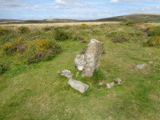
Buckland Common Round House
OS Map: SX 73699 73775
HER: MDV30626
ShortName: HT:Buckland 2
Nearby sites: SX 73699 73775
Distance: 2.64km
Buckland Common Round House
OS Map: SX 73536 73997
HER: MDV31020
ShortName: HT:Buckland 6
Nearby sites: SX 73536 73997
Distance: 2.72km
Buckland Common Round House
OS Map: SX 73454 73929
HER: MDV7995
ShortName: HT:Buckland 7
Nearby sites: SX 73454 73929
Distance: 2.62km
Bench Tor Round House
OS Map: SX 69081 71484
HER: MDV6447
ShortName: HT:Bench Tor1
Nearby sites: SX 69081 71484
Distance: 2.93km
Buckland Common Round House
OS Map: SX 73447 73831
HER: MDV7995
ShortName: HT:Buckland 8
Nearby sites: SX 73447 73831
Distance: 2.53km
Buckland Common Round House
OS Map: SX 73442 73748
HER: MDV7995
ShortName: HT:Buckland 9
Nearby sites: SX 73442 73748
Distance: 2.46km
Buckland Common 1 Reported Cairn
OS Map: SX 73772 73930
ShortName: CN-Buckland 2
Butler map: 10.
Notes: Linear arrangement of mounds incorporated into boundary. Could be prehistoric cairns.
Nearby sites: SX 73772 73930
Distance: 2.81km
Bench Tor Round House
OS Map: SX 69015 71451
HER: MDV6447
ShortName: HT:Bench Tor3
Nearby sites: SX 69015 71451
Distance: 3.00km
Buckland Common Round House
OS Map: SX 73432 73867
HER: MDV7995
ShortName: HT:Buckland 10
Nearby sites: SX 73432 73867
Distance: 2.56km
Buckland Common 2 Reported Cairn
OS Map: SX 73742 73865
HER: MDV30646
ShortName: CN Buckland 3
Butler map: 10.
Notes: HER: "A flattened and spread round cairn straddles the parish boundary between Buckland and Ashburton. A boundary stone is set into the cairn."
Nearby sites: SX 73742 73865
Distance: 2.74km
Buckland Common Round House
OS Map: SX 73392 73880
HER: MDV7995
ShortName: HT:Buckland 11
Nearby sites: SX 73392 73880
Distance: 2.54km
Buckland Common 3 Reported Cairn
OS Map: SX 73588 73559
ShortName: CN?Buckland 4
Butler map: 10.8
Notes: Linear arrangement of mounds incorporated into boundary. Could be prehistoric cairns.
Nearby sites: SX 73588 73559
Distance: 2.41km
Buckland Common Round House
OS Map: SX 73483 74146
HER: MDV8017
ShortName: HT:Buckland 12
Nearby sites: SX 73483 74146
Distance: 2.82km
Buckland Common 4 Reported Cairn
OS Map: SX 73587 73556
ShortName: CN?Buckland 5
Butler map: 10.8
Notes: Linear arrangement of mounds incorporated into boundary. Could be prehistoric cairns.
Nearby sites: SX 73587 73556
Distance: 2.40km
Rushlade Common Round House
OS Map: SX 74245 73555
HER: MDV25176
ShortName: HT:Rushlade 1
Nearby sites: SX 74245 73555
Distance: 2.88km
Buckland Beacon Cairn
OS Map: SX 73510 73118
HER: MDV7977
ShortName: CN Buckland 1
Butler map: 10.
Grinsell: B:BITM 1
Nearby sites: SX 73510 73118
Distance: 2.04km
Bench Tor Round House
OS Map: SX 69015 71451
HER: MDV6447
ShortName: HT:Bench Tor8
Nearby sites: SX 69015 71451
Distance: 3.00km
Rushlade Common Round House
OS Map: SX 74335 73555
HER: MDV25176
ShortName: HT:Rushlade 2
Nearby sites: SX 74335 73555
Distance: 2.95km
Brake Corner 1 Cairn
OS Map: SX 7022 7170
HER: MDV8030
ShortName: CN?Brake Cor1
Butler map: 11.1.1
Turner: A17
Notes: Hut circle at brake corner. Bronze age. Vis=19/5/1960 (os) a circular enclosure bounded by a bank consisting of small stones. Part of the interior has been filled in with cleared field stones. No trace of entrance. No orthostats visible and construction using small stones is unusual for a hut. The exposed situation on crest of spur is more appropriate to a cairn but the walling at best about 0.4m high appears too regular for a cairn rim.
Nearby sites: SX 7022 7170
Distance: 1.78km
Brake Corner 2 Reported Cairn
OS Map: SX 7018 7168
ShortName: CN?Brake Cor2
Butler map: 11.1.2
Notes: Possible hut circle.
Nearby sites: SX 7018 7168
Distance: 1.82km
Mel Tor Round House
OS Map: SX 69524 72537
HER: MDV6453
ShortName: HT Mel Tor1
Nearby sites: SX 69524 72537
Distance: 2.60km
Mel Tor Round House
OS Map: SX 6943 7263
HER: MDV26252
ShortName: HT:Mel Tor2
Nearby sites: SX 6943 7263
Distance: 2.72km
Leusdon Round House
OS Map: SX 7049 7325
HER: MDV25125
ShortName: HT:Leusdon1
Nearby sites: SX 7049 7325
Distance: 2.13km
Mel Tor Round House
OS Map: SX 69105 71451
HER: MDV6447
ShortName: HT:Mel Tor3
Nearby sites: SX 69105 71451
Distance: 2.91km
Bench Tor S. Reported Cairn
OS Map: SX 6916 7140
HER: MDV-1
ShortName: CN?Bench Tor1
Butler map: 59.2
Notes: Butler: in the field system "a small mound near the north end was probably a cairn".
Nearby sites: SX 6916 7140
Distance: 2.86km
Buckland Ridge (N) Cairn
OS Map: SX 73579 73510
HER: MDV30631
ShortName: CN:Buckland 9
Turner: A47
Nearby sites: SX 73579 73510
Distance: 2.36km
Spitchwick Manor Round House
OS Map: SX 7096 7261
HER: MDV25124
ShortName: HT:Spitchwic1
Nearby sites: SX 7096 7261
Distance: 1.35km
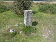
Buckland Down Reported Cist
OS Map: SX 735 740
HER: MDV-1
PMD: Buckland Down
ShortName: CT?Buckland 7
Notes: Butler Vol 1 p.115. One burial mound awaiting rediscovery is the cairncircle surrounding a cist on 'Buckland Down' mentioned in Note 43 to Carrington's poem on Dartmoor.
Nearby sites: SX 735 740
Distance: 2.70km
Brake Corner Round House
OS Map: SX 70222 71727
HER: MDV8030
ShortName: HT:Brake Cor1
Nearby sites: SX 70222 71727
Distance: 1.78km
Aish Tor E Round House
OS Map: SX 7060 7155
HER: MDV25133
ShortName: HT:Aish Tor 1
Nearby sites: SX 7060 7155
Distance: 1.41km
Hannaford Round House
OS Map: SX 708 708
HER: MDV25139
ShortName: HT:Hannaford1
Nearby sites: SX 708 708
Distance: 1.53km
Deeper Marsh Round House
OS Map: SX 7138 7124
HER: MDV25137
ShortName: HT:Deeper Ma1
Nearby sites: SX 7138 7124
Distance: 0.80km
Welstor Round House
OS Map: SX 74574 73274
HER: MDV8027
ShortName: HT:Welstor1
Nearby sites: SX 74574 73274
Distance: 2.99km
Welstor Round House
OS Map: SX 74005 73415
HER: MDV25185
ShortName: HT:Welstor2
Nearby sites: SX 74005 73415
Distance: 2.61km
Welstor Round House
OS Map: SX 740 734
HER: MDV25185
ShortName: HT:Welstor3
Nearby sites: SX 740 734
Distance: 2.59km
Ausewell Common Round House
OS Map: SX 7340 7118
HER: MDV25143
ShortName: HT:Ausewell 1
Nearby sites: SX 7340 7118
Distance: 1.51km
Ausewell Common Round House
OS Map: SX 73265 71185
HER: MDV25142
ShortName: HT:Ausewell 2
Nearby sites: SX 73265 71185
Distance: 1.39km
Ausewell Common Round House
OS Map: SX 73265 71205
HER: MDV25142
ShortName: HT:Ausewell 3
Nearby sites: SX 73265 71205
Distance: 1.38km
West Shallowford Round House
OS Map: SX 6955 7263
HER: MDV26251
ShortName: HT:West Shal2
Nearby sites: SX 6955 7263
Distance: 2.60km
Ausewell Common Round House
OS Map: SX 73255 71195
HER: MDV25142
ShortName: HT:Ausewell 4
Nearby sites: SX 73255 71195
Distance: 1.37km
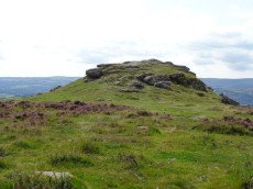
Ausewell Rocks W. Cairn
OS Map: SX 73477 71753
HER: MDV7988
ShortName: CN:Ausewell 2
Grinsell: ASH 2
Barrow Report: 41
Notes: "diameter 18.0m, crude stone wall around cairn obviously modern survives as a semi circular enclosure on west side of cairns flat top."
Nearby sites: SX 73477 71753
Distance: 1.48km
Ausewell Rocks E. Cairn
OS Map: SX 73548 71735
HER: MDV8019
ShortName: CN:Ausewell 1
Grinsell: ASH 3
Barrow Report: 41
Nearby sites: SX 73548 71735
Distance: 1.55km
Kingshead Reported Cairn
OS Map: SX 7300 7232
HER: MDV20513
ShortName: CN?Kingshead
Nearby sites: SX 7300 7232
Distance: 1.15km
Buckland Beacon Ancient Pool
OS Map: SX 73558 73260
HER: MDV127202
ShortName: PO:Buckland
Notes: "A pool measuring 10.5 by 9.5m. One of over 40 such 'sacred' pools identified on Dartmoor that are thought to have potentially been designed during the prehistoric period. Lies near a cairn." NB. Nearby is Turner A13 ring cairn.
Nearby sites: SX 73558 73260
Distance: 2.17km
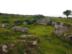
Buckland Ridge (S) Stone Ring Cairn Circle
OS Map: SX 7357 7324
HER: MDV30630
Megalithic Portal: 45827
Alternate name: Buckland Common 5 Stone Ring Cairn Circle
ShortName: RC:BucklandRid
Butler map: 10.9
Turner: A13
Notes: Linear arrangement of mounds incorporated into boundary. Could be prehistoric cairns. Turner A13. No NMR record. "Robbed cairn. Stone ring is 13m inside diameter bank 1.80m wide and 50cms high, much of the bank on the eastern side has been destroyed. The central area has been disturbed, modern stone wall running north to south through the eastern section of the stone ring."
Nearby sites: SX 7357 7324
Distance: 2.16km
Holne Chase Castle Fort Fort
Prehistoric Dartmoor Walks: Dartmoor Resource: Table of Devon Iron Age Forts
OS Map: SX 72437 71979
HER: MDV7996
Alternate name: Holne Chase Castle Fort
ShortName: FT:HolneChase
Notes: "A slight univallate hillfort situated on the north facing side of Holne Chase overlooking the River Dart. The hillfort survives as an oval enclosure measuring 120m long by 96m wide internally, defined by a single rampart and ditch with a counterscarp bank present to the north east, west and south west. It has two entrances, a simple gap to the south east and an inturned entrance to the south west."
Nearby sites: SX 72437 71979
Distance: 0.49km