
Holne Chase Castle Fort
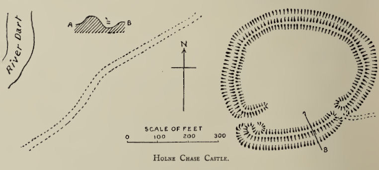
Plan: J.C. Wall in Ancient Earthworks (1906)
Database entries
PDW coverage: Dartmoor Resource: Table of Devon Iron Age Forts
OS Map: SX 72437 71979
OS Source: Google
HER: MDV7996
Megalithic Portal: 62571
Alternate name: Holne Chase Castle
Short Name: FT:HolneChase
Exist: Yes
Record: Unique
Record Source: PDW
Hut Class: No
Dimensions (m): 3.5 acres
Lidar: SX 72437 71979
Guide Map: 41
Nearest Bus Stop: Ashburton Bull Ring (4.9 km) [Route: 38,88]
Nearby sites: SX 72437 71979
Notes
"A slight univallate hillfort situated on the north facing side of Holne Chase overlooking the River Dart. The hillfort survives as an oval enclosure measuring 120m long by 96m wide internally, defined by a single rampart and ditch with a counterscarp bank present to the north east, west and south west. It has two entrances, a simple gap to the south east and an inturned entrance to the south west."References
These are selected references with an emphasis on out of copyright sources linked as PDFs. For more detailed references try any linked HER or PMD record above.
- Amery, P. F. S., Some hitherto unrecorded Hill Fortresses near Ashburton, T.D.A. Vol.6 Part 1 pp.261-265 (1873)
- Amery, P. F. S., Supposed Currency Bars, Holne Chase, T.D.A. Vol.38 pp.370-376 (1906)
- Brailsford, J. W, Bronze Age Stone Monuments of Dartmoor, Antiquity Volume 12, Number 48 pp.444-63 (1938)
- Gerrard, Sandy, English Heritage Book of Dartmoor: Landscapes Through Time, (1997)
- Newman, Phil, The Field Archaeology of Dartmoor, (2011)
- Pilkington-Rogers, C. W., The Date of the Dartmoor Antiquities, T.D.A. Vol.64 pp.379-388 (1932)
- Wall, J. Charles, Ancient Earthworks, The Victoria History of the County of Devon: v. 1 pp.573-630 (1906)