
Prehistoric sites within 2km of SX 66900 62700
Guidance for walkers: The monuments featured in this database are archaeological treasures and need to be protected and preserved - please do not disturb any sites. Please check access and firing times before visiting sites, not all sites listed are on open access land. Firing ranges and boundaries of open access areas are marked on the OL28 OS Dartmoor Explorer map. Please stick to the country code and consider giving support to the numerous agencies that help to keep Dartmoor a fabulous natural and historic environment!
About the database listings: In all listings clicking on the photo or the site name will open a page for the site with a larger photo and further details from the database. The database now has over 6680 records covering nearly all publicly listed sites on Dartmoor including around 4800 round houses. This level of detail is of interest to archaeologists but tends to swamp listings of sites more likely to be of interest for walkers. For this reason, the listings default to around 550 core sites only. These are the stone circles, stone rows and the ring cairns listed by Turner. The default search radius is 2 km. The controls below the map can be used to start a new search by entering a 6- or 8-digit reference (without the prefix "SX"). The search radius can be specified and you can add incremental Display layers of detail on top of the core sites. If using a more detailed layer you will need to decrease the search radius to avoid getting hundreds of search results.
- Core sites Default listing of core sites consisting of stone circles & rows and some of the major ring cairns.
- Plus cairns adds approx. 1000 cairns and other minor sites not included in the core listings but excluding round houses.
- Plus round houses adds approx. 4800 round houses.
- Plus non-sites adds in the records for sites that no longer exist or are not prehistoric sites.
- Plus duplicates adds records excluded as duplicates. Those maybe duplicate records in external listings (e.g. the Historic Environment Records). For example, some sites have been identified as cairns in some listings and interpreted as round houses in other listings and both records appear.
These listings have incorporated, matched up and merged all of the records from all of the major archaeological listings including: Worth, Grinsell, Turner, Butler, Bill Radcliffe, Sandy Gerrard, Megalithic Portal, the National Monument Records and the Historic Environment Records. The author would like to thank Bill, Sandy, the lovely people both at Megalithic Portal (especially Anne Tate who did an amazing job to link listings) and at ACE Archaeology for collaborative work over the years to synchronise and correct listings across the various websites which now interlink. A culmination of years of work the final merger of cairn records took 3 months of cross referencing in 2017 the result being a snapshot of the records at that time. This data has in turn been refined since by field work and research. The round house data was supplied by Sandy Gerrard. Grid references are in order of accuracy: from Google Earth satellite, if visible and found, from a Garmin GPS reading, if visited by the author and from the literature otherwise. Individual site pages will state the source of the grid reference and provide satellite imagery. If a site listing lacks a photo it has not yet been visited by the author in which case the grid reference is from the literature.
Currently the database only includes sites which can be represented by a grid reference. Reaves are not included as they require GIS shape technology which is beyond the current capability of this system. To see the sources for the records, look at the tables on the resources menu. The database listings can also be viewed on a Google map and downloaded as GPS datasets for Garmin devices.
Corrections, or any feedback or suggestions are very welcome, email: info@dartmoorwalks.org.uk.
NOTE: Clicking on the icons for each monument in the map will give the name of the site. You can zoom in and out and drag the map around.
List of sites within 2km of SX 66900 62700
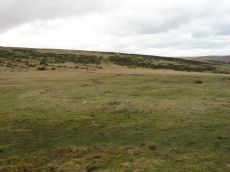
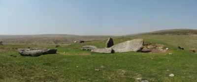
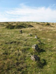
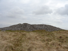
Ball Gate Stone Ring Cairn Circle
Prehistoric Dartmoor Walks: Dartmoor Walk: The Erme East stone rows
OS Map: SX 66996 61306
HER: MDV7739
Megalithic Portal: 45839
PMD: Corringdon Ball Gate cairn
Alternate name: Corringdon Ball N. Stone Ring Cairn Circle
ShortName: RC Ball Gate
Butler map: 56.10
Grinsell: BRE 9
Turner: A43
Barrow Report: 28 66
Notes: "A very vague circle 21m diameter, which may be the remains of a mutilated cairn. Vis=-/4/1977 (ancient monuments) possibly rather damaged on one side. Vis=23/6/1973 (grinsell, l. V. ). Site of cairn almost levelled probably for material to build the adjoining wall. Shown on OS 6" as 'cairn circle'. Diameter 21m, height 0.4m. Vis=28/7/1977 (os) there is a gap in the rim on the southeast, probably for carts taking away the stone".
Nearby sites: SX 66996 61306
Distance: 1.40km
Black Tor (Avon) Stone Row
OS Map: SX 67730 63494
HER: MDV28589
Megalithic Portal: 1772
The Stone Rows of GB: Black Tor Avon Stone Row
PMD: Black Tor Avon Stone Row
ShortName: SR BlackTor 1
Butler map: 57.25
DPD page: 85
Notes: "A stone row running north west - south east seen on the plateau west of Black Tor". The stones are very hidden and difficult to see. The row is headed at the NW end by two small cairns. Lethbridge suggests remains of cist in one of them, diagram p.85. See also HER 5752, SX 66 SE 89 and SX 66 SE 33. NB. There is also a possible second row about 200 metres away SiteID=1320
Nearby sites: SX 67730 63494
Distance: 1.15km
Brent Fore Hill Stone Row
Prehistoric Dartmoor Walks: Dartmoor Walk: The Neolithic tombs of Cuckoo Ball & Corringdon Ball
OS Map: SX 66848 61345
HER: MDV5765
Megalithic Portal: 1777
The Stone Rows of GB: Brent Fore Hill
PMD: Brent Fore Hill Stone Row
ShortName: SR Brent Fore
Butler map: 56.10
DPD page: 83
Barrow Report: 66
Notes: "The remains of a stone row and cairn on Brent Fore Hill. The row is crossed by two leats, one of which is now disused. The cairn is visible as a low mound of turf-covered stones of 13.5 metres in diameter and 0.3 metres high". Lethbridge East Glaze Brook stone row p.83. See also: Sea Views at Brent Fore Hill
Nearby sites: SX 66848 61345
Distance: 1.36km
Brent Forehill Encircled Cairn
Prehistoric Dartmoor Walks: Dartmoor Walk: The Neolithic tombs of Cuckoo Ball & Corringdon Ball
OS Map: SX 66854 61356
HER: MDV13282
Megalithic Portal: 1777
PMD: Brent Fore Hill Stone Row
Alternate name: Brent Fore Hill stone row Encircled Cairn
ShortName: EC BrentForeSR
Butler map: 56.10
Grinsell: BRE 8
Turner: F23
Barrow Report: 66
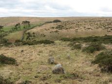
Notes: The remains of a stone row and cairn on Brent Fore Hill. The row is crossed by two leats, one of which is now disused. The cairn is visible as a low mound of turf-covered stones of 13.5 metres in diameter and 0.3 metres high. Photo shows 2 or 3 stones of the cairn - it is not very photogenic! Turner F23.
Nearby sites: SX 66854 61356
Distance: 1.34km
Brent Moor House Cist
OS Map: SX 6802 6403
HER: MDV5744
Megalithic Portal: 45754
PMD: Brent Moor House
ShortName: CT:Brent Moor
Grinsell: BRE 3
Barrow Report: 65 66
Notes: "A cist lies on the right bank of the Avon, a short distance above Brent Moor House, about 175 feet below the small stream which flows south of Riders Rings ... The cist, which consists of two end stones and one side stone, stands in a small cairn." Doubtful. (grinsell) "supposed cairn of large stones, enclosing possible cist placed se-nw. The whole area is covered with clitter, and it is possible that the site may be natural. In summer it is under dense bracken. No measurements given." Butler Vol. 4. Map 57.9 (not actually covered in Butler but relevant map). " A Medieval or later tinner's cache situated opposite Woolholes on the west bank of the River Avon. Considered under the Monument Protection Programme by previous Monument Protection Programme Advisor who did not recommend it for scheduling."
Nearby sites: SX 6802 6403
Distance: 1.74km
Corringdon Ball Chambered Tomb
Prehistoric Dartmoor Walks: Dartmoor Site: Corringdon Ball Chambered Tomb & Stone Rows
OS Map: SX 66956 61300
HER: MDV5750
Megalithic Portal: 4619
PMD: Corringdon Ball Chambered Cairn
Alternate name: Corringdon Ball chambered tomb Chambered Tomb
ShortName: NT Corringdon
Butler map: 56.10
Butler Vol 5: p.155
DPD page: 83
Grinsell: A:BRE 1
Barrow Report: 28 56 66
Notes: "An earthen long barrow with a ruined stone chamber at the south east end. Early excavation and mutilation has resulted in two distinct mounds, the larger one at the south east end separated from the smaller by a path or trackway. The smaller mound appears to mark the limit of the barrow on the northwest; beyond this it merges into the natural hill-side. There are no side ditches but these may be obscured by soil washed down from the hill. The length is 42.0 m; the maximum width is 18.0m and the maximum height of 2.4m."
Nearby sites: SX 66956 61300
Distance: 1.40km
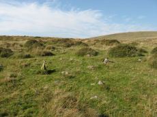
Corringdon Ball Ceremonial Complex
Prehistoric Dartmoor Walks: Dartmoor Site: Corringdon Ball Chambered Tomb & Stone Rows
OS Map: SX 6666 6121
HER: MDV129970
Megalithic Portal: 10454
ShortName: CX CorringdonB
Notes: Close to the Corringdon Ball Chambered Tomb is a complex of multiple rows and numerous multiple ringed cairns.
Nearby sites: SX 6666 6121
Distance: 1.51km
Corringdon Ball Multiple Cairn Circle
Prehistoric Dartmoor Walks: Dartmoor Site: Corringdon Ball Chambered Tomb & Stone Rows
OS Map: SX 66665 61215
HER: MDV15960
Megalithic Portal: 52282
PMD: Corringdon Ball B
Alternate name: Corringdon Ball 5 Cairn Circle
ShortName: CC Corringdo5
Butler map: 56.8.5
DPD page: 82
Notes: Five monuments noted by robinson and greeves at the ne end of the stone rows. Many have multiple concentric circles of small stones. Includes 3 cairns. See also entries for Corringdon Ball Stone Rows and East Glazebrook Encircled Cairn. Lethbridge p.82-3.
Nearby sites: SX 66665 61215
Distance: 1.50km
Corringdon Ball N. Stone Row
Prehistoric Dartmoor Walks: Dartmoor Site: Corringdon Ball Chambered Tomb & Stone Rows
OS Map: SX 66661 61206
HER: MDV5656
Megalithic Portal: 1856
The Stone Rows of GB: Corringdon Ball North
PMD: Corringdon Ball A Stone Row
Alternate name: Corringdon Ball North Stone Row
ShortName: SR CorringdonN
Butler map: 56.8.2
DPD page: 82
Barrow Report: 66
Notes: "A single stone row, length 157 metres, spacing 1.0 metres, starting on the east with a cairn, diameter 6.7 metres, previously opened. The first stone of the row lies 18 metres west of the cairn's centre; there has been considerable robbery for the benefit of modern stone walls. The row clearly extends for 157 metres from the centre of the cairn, but with long intervals between the last stones. The stones are small, the highest being 635 millimetres." See also entry for Corringdon Ball Row B. p.82
Nearby sites: SX 66661 61206
Distance: 1.51km
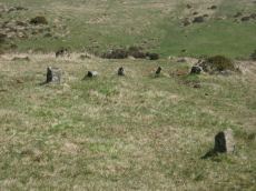
Corringdon Ball S. Stone Row
Prehistoric Dartmoor Walks: Dartmoor Site: Corringdon Ball Chambered Tomb & Stone Rows
OS Map: SX 66684 61205
HER: MDV5655
Megalithic Portal: 1857
The Stone Rows of GB: Corringdon Ball South
PMD: Corringdon Ball B Stone Row
Alternate name: Corringdon Ball South Stone Row
ShortName: SR CorringdonS
Butler map: 56.8.1
DPD page: 82
Barrow Report: 66
Notes: "Corringdon ball stone rows. Six or seven rows of small stones approximately 75m long, terminating at the east end in a small semi-circular stone setting of five stones, none more than 500mm high, and the alignments are irregular - they run along the contours. Situated on the open moor between the east and west glaze brooks. A complicated set of stones which can only be aligned into rows by exact survey. The direction of the rows is approximately south west". Described by R H Worth as two triple rows B & C. See also HER 14802 (Corringdon Ball B).
Nearby sites: SX 66684 61205
Distance: 1.51km

East Glazebrook Platform Cairn Circle
Prehistoric Dartmoor Walks: Dartmoor Walk: The Neolithic tombs of Cuckoo Ball & Corringdon Ball
OS Map: SX 66623 61237
HER: MDV15960
Megalithic Portal: 808
Alternate name: Corringdon Ball 6 Platform Cairn Circle
ShortName: PC Corringdo6
Butler map: 56.8.6
Grinsell: UGB 3a
Turner: E50
Barrow Report: 68
Notes: Platform Cairn with Outer Stone Circles. "A ruined cairn with a very stony centre and the remains of multiple concentric rings of small stones visible on the south side. A substantial bank survives on the north side." Lethbridge p.82
Nearby sites: SX 66623 61237
Distance: 1.49km
East Glazebrook Encircled Cairn
Prehistoric Dartmoor Walks: Dartmoor Site: Corringdon Ball Chambered Tomb & Stone Rows
OS Map: SX 66679 61215
HER: MDV129970
Megalithic Portal: 3160
PMD: Corringdon Ball C Stone Row
Alternate name: Corringdon Ball stone rows 1 Encircled Cairn
ShortName: EC East Glaze
Butler map: 56.8.1
DPD page: 82
Grinsell: UGB 4
Turner: F14
Barrow Report: 66 68
Notes: Cairn at east end of the Corringdon Ball group of multiple stone rows . Six pillars of the retaining circle are clearly visible. For more detail see entries for the Corringdon Ball rows.
Nearby sites: SX 66679 61215
Distance: 1.50km
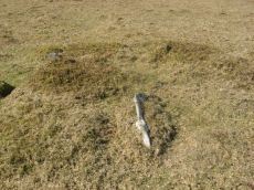
Hickley Ridge Central Cist
OS Map: SX 67224 62250
HER: MDV61772
Megalithic Portal: 45810
PMD: Hickley Ridge Central
Alternate name: Hickley Ridge 2 Cist
ShortName: CT HickleyCe
Butler map: 56.14.3
Butler Vol 5: p.175 & Fig.117
DPD page: 84
Notes: Butler Hickley Ridge Cairn and Cist 2. 56.14.3 diagram Vol 5 p.175. "Two slabs, possibly of a cist, embedded in low mound south of the leat on Hickley Ridge." Lethbridge diagram p.84, photo bottom left.
Nearby sites: SX 67224 62250
Distance: 0.55km
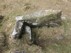
Hickley Ridge E Cist
OS Map: SX 67402 62381
HER: MDV61773
Megalithic Portal: 45811
PMD: Hickley Ridge E.
Alternate name: Hickley Ridge 1 Cist
ShortName: CT HickleyE
Butler map: 56.14.2
Butler Vol 5: p.175 & Fig.116
DPD page: 84
Notes: Butler Hickley Ridge Cist 1. 56.14.3 diagram Vol 5 p.175. "One side and one end slab of cist on Hickley Ridge, with other fallen stones in the mound. One of three badly damaged cists aligned south-west to north-east across Hickley Ridge, recognised by Butler in 1995." Lethbridge diagram and photo on right of p.84.
Nearby sites: SX 67402 62381
Distance: 0.59km
Hickley Ridge W Cist
OS Map: SX 6659 6203
HER: MDV13283
Megalithic Portal: 45809
PMD: Hickley Ridge W.
Alternate name: Hickley Ridge 3 Cist
ShortName: CT:HickleyW
Butler map: 56.14.4
Butler Vol 5: p.176 & Fig.118
DPD page: 84
Notes: "Cairn and cist on the East side of Brent Fore Hill. The cairn is 6.0m in diameter, merging into the slope of the hill and being about 0.5m high on the downslope side, which has a retaining kerb. There is a central cist of which two parallel slabs remain set on edge at the NW and SE sides. An upright stone 0.9m high is offset from the cist on the NW side." Lethbridge p.84 diagram and photo top left. Butler Hickley Ridge 3 56.14.4 diagram Vol 5 p.176.
Nearby sites: SX 6659 6203
Distance: 0.74km
Knatta Barrow Stone Ring Cairn Circle
OS Map: SX 65970 64212
HER: MDV5717
Megalithic Portal: 45842
ShortName: RC:Knatta Bar
Butler map: 57.29
Butler Vol 5: p.160 & Fig.102
Grinsell: BRE 2
Turner: A54
Notes: "This large cairn (24m diameter, 1.7m height) composed of loose granite boulders. It is unusual among summit cairns in having a well defined outer bank about 1m wide and 0.5m high. This is partly turf covered but where eroded can be seen to be built of loose stone like the central cairn which touches it. It shows best on the north and east sides, while on the south west side it tends to merge into the body of the cairn."
Nearby sites: SX 65970 64212
Distance: 1.78km
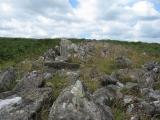
Riders Rings Enclosed Settlement
OS Map: SX 67870 64359
HER: MDV5767
Megalithic Portal: 45321
ShortName: ES RidersRings
DPD page: 85
Notes: "The largest and most important pound in the Avon Valley. Situated on the eastern slope of Zeal Plains. It is best regarded as being two contiguous pounds, of which it would appear that the south west member was constructed first, while the north east member was added as a later extension. The two pounds together cover an area of over six acres and enclose some three dozen hut-circles". Lethbridge p.85
Nearby sites: SX 67870 64359
Distance: 1.92km
Sharp Tor Standing Stone
OS Map: SX 651 619
HER: MDV5709
ShortName: SS:Sharp Tor
Notes: NGR is estimated. Source Worth, HER: Sharp tor. Alongside one of the modern boundary stones lies what may be a fallen menhir. See The Dartmoor Menhirs p.193
Nearby sites: SX 651 619
Distance: 1.97km
Three Barrows Cairn
Prehistoric Dartmoor Walks: Dartmoor Walk: The Erme East stone rows
OS Map: SX 65315 62601
HER: MDV5666
Megalithic Portal: 45593
PMD: Three Barrows NW
Alternate name: Three Barrows Central Cairn
ShortName: CN 3 Barrows
Butler map: 54.20
Butler Vol 5: p.53
Grinsell: BRE 6
Barrow Report: 1 56 63
Notes: "Three very large cairns known as the Three Barrows (see SX 66 SE 54, 56), one of which, being about 50 yards in diameter, and 8 feet high, is reputed to be perhaps the largest on Dartmoor". See also HER Southern cairn 5830 and HER Northern cairn 5746
Nearby sites: SX 65315 62601
Distance: 1.59km
Treeland Brake Stone Row
OS Map: SX 6741 6158
HER: MDV5827
Megalithic Portal: 6333473
The Stone Rows of GB: Treeland Brake
PMD: Treeland Brake Stone Row
ShortName: SRxTreeland Bk
Butler map: 56.11
Notes: Notes from the NMR record: "Treeland Brake Stone Row. The only record of the row is a photograph taken by Mr HG Hurrell in the late 1950s. Mr Hurrell remembers about five erect stones and about five fallen, aligned north-east to south-west. The row has been destroyed by agricultural activity by 1977. (Photograph is in the possession of S & M Register)." Also: "A colour print taken by Mr Hurrell from approximately SX 67206130 shows the stones aligned to a field corner at SX 67296147. Approximate centre of row, SX 67276141; the area is now under pasture."
Nearby sites: SX 6741 6158
Distance: 1.23km
Upper Glazebrook Neolithic Enclosure
Prehistoric Dartmoor Walks: Dartmoor Site: Corringdon Ball Chambered Tomb & Stone Rows
OS Map: SX 6636 6126
HER: MDV5692
Megalithic Portal: 45594
ShortName: NE Upper Glaze
Butler Vol 5: p.155
Notes: A rectangular enclosure not far from Corringdon Ball chambered tomb measuring 112m by 34m that can be seen clearly on aerial and satellite photos of the area. The walls are up to 1.5m thick and 0.3m high, and have been entirely destroyed on the east and north-west sides. There is no obvious entrance and the interior is empty of any structure. According to Butler the east to west orientation of the long axis could suggest a mortuary enclosure of mid-neolithic date (Vol 5 pp.155-6).
Nearby sites: SX 6636 6126
Distance: 1.54km