
Prehistoric sites within 2km of SX 62000 78500
Guidance for walkers: The monuments featured in this database are archaeological treasures and need to be protected and preserved - please do not disturb any sites. Please check access and firing times before visiting sites, not all sites listed are on open access land. Firing ranges and boundaries of open access areas are marked on the OL28 OS Dartmoor Explorer map. Please stick to the country code and consider giving support to the numerous agencies that help to keep Dartmoor a fabulous natural and historic environment!
About the database listings: In all listings clicking on the photo or the site name will open a page for the site with a larger photo and further details from the database. The database now has over 6680 records covering nearly all publicly listed sites on Dartmoor including around 4800 round houses. This level of detail is of interest to archaeologists but tends to swamp listings of sites more likely to be of interest for walkers. For this reason, the listings default to around 550 core sites only. These are the stone circles, stone rows and the ring cairns listed by Turner. The default search radius is 2 km. The controls below the map can be used to start a new search by entering a 6- or 8-digit reference (without the prefix "SX"). The search radius can be specified and you can add incremental Display layers of detail on top of the core sites. If using a more detailed layer you will need to decrease the search radius to avoid getting hundreds of search results.
- Core sites Default listing of core sites consisting of stone circles & rows and some of the major ring cairns.
- Plus cairns adds approx. 1000 cairns and other minor sites not included in the core listings but excluding round houses.
- Plus round houses adds approx. 4800 round houses.
- Plus non-sites adds in the records for sites that no longer exist or are not prehistoric sites.
- Plus duplicates adds records excluded as duplicates. Those maybe duplicate records in external listings (e.g. the Historic Environment Records). For example, some sites have been identified as cairns in some listings and interpreted as round houses in other listings and both records appear.
These listings have incorporated, matched up and merged all of the records from all of the major archaeological listings including: Worth, Grinsell, Turner, Butler, Bill Radcliffe, Sandy Gerrard, Megalithic Portal, the National Monument Records and the Historic Environment Records. The author would like to thank Bill, Sandy, the lovely people both at Megalithic Portal (especially Anne Tate who did an amazing job to link listings) and at ACE Archaeology for collaborative work over the years to synchronise and correct listings across the various websites which now interlink. A culmination of years of work the final merger of cairn records took 3 months of cross referencing in 2017 the result being a snapshot of the records at that time. This data has in turn been refined since by field work and research. The round house data was supplied by Sandy Gerrard. Grid references are in order of accuracy: from Google Earth satellite, if visible and found, from a Garmin GPS reading, if visited by the author and from the literature otherwise. Individual site pages will state the source of the grid reference and provide satellite imagery. If a site listing lacks a photo it has not yet been visited by the author in which case the grid reference is from the literature.
Currently the database only includes sites which can be represented by a grid reference. Reaves are not included as they require GIS shape technology which is beyond the current capability of this system. To see the sources for the records, look at the tables on the resources menu. The database listings can also be viewed on a Google map and downloaded as GPS datasets for Garmin devices.
Corrections, or any feedback or suggestions are very welcome, email: info@dartmoorwalks.org.uk.
NOTE: Clicking on the icons for each monument in the map will give the name of the site. You can zoom in and out and drag the map around.
List of sites within 2km of SX 62000 78500
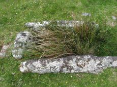
Littaford Tor E Cist
OS Map: SX 61846 76717
PMD: Littaford Tor E.
ShortName: CT Littaford 1
Notes: Radcliffe: "Long axis approx W-E . Stones visible on N ,E and S sides and some stone could be felt under grass on W side. Approx. 1m x 0.5m x 0.5m depth internally. No obvious sign of cairn mound. No obvious stonecutting in vicinity. TAP Greeves (pers. comm.) "
Nearby sites: SX 61846 76717
Distance: 1.79km
Arch Tor Platform Cairn Circle
OS Map: SX 63168 77843
HER: MDV21510
Megalithic Portal: 45618
Alternate name: Arch Tor 1 Platform Cairn Circle
ShortName: PC Arch Tor 1
Butler map: 27.6
Turner: E11
Notes: "A round cairn which survives as an 8.7 metre diameter mound standing up to 0.9 metres high. Large edge set stones on the north western edge of the mound may suggest the presence of a kerb which survives elsewhere as a buried feature."
Nearby sites: SX 63168 77843
Distance: 1.34km
Archerton S.W. (Rowtor Brook) Ring Setting Cairn and Cist
OS Map: SX 62752 78808
HER: MDV5838
Megalithic Portal: 37604
PMD: Hollowcombe Bottom
Alternate name: Rowtor Brook 3 Ring Setting Cairn and Cist
ShortName: CT RowtorBr 3
Butler map: 27.17.3
Butler Vol 5: p.55 & Fig.33
DPD page: 112
Grinsell: LYD 42
Turner: D24
Barrow Report: 57
Notes: Breton: on N. side of wall is a kistvaen, around which is a triple circle, a very unusual feature..
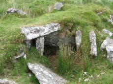
HER: The cist lies within three concentric circles of stones at 10, 15 and 24 feet diameters, the inner ring being of large stones, the middle ring of smaller stones and the outer ring of even smaller stones. The cist measures internally 0.8m by 0.6m and 0.9m deep. Half of its capstone lies across its north end.
For more information see: Lethbridge Hollowcombe Bottom, diagram and photo p.112. Butler Rowtor Brook 3 - Vol. 2. Map 27.17 (diagram Vol. 5. p.55). Breton p.35
Nearby sites: SX 62752 78808
Distance: 0.81km
Archerton Tennis Ground Platform Cairn Circle and Cist
OS Map: SX 63852 78872
HER: MDV5839
Megalithic Portal: 37599
PMD: Archerton Tennis Court
Alternate name: Archerton Platform Cairn Circle and Cist
ShortName: CT Arch Tennis
Butler map: 27.18
DPD page: 114
Grinsell: LYD 45
Turner: E49
Barrow Report: 57
Notes: Lethbridge diagram p.112, photo top p.114. Butler Archerton - Vol. 2. Map 27.18. Breton p.37 Its four sides are complete, the capstone is partially buried; it stands on a slight mound and has been enclosed by a circle of small stones which are nearly buried under the turf.
Nearby sites: SX 63852 78872
Distance: 1.89km
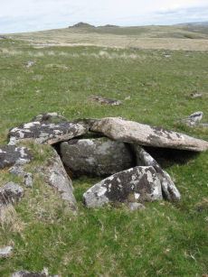
Beardown Platform Cairn Circle and Cist
OS Map: SX 60330 78092
HER: MDV14690
Megalithic Portal: 42853
PMD: Lydford Tor
Alternate name: Lydford Tor E. Platform Cairn Circle and Cist
ShortName: CT Beardown
Butler map: 29.17
Butler Vol 5: p.197 & Fig.140
DPD page: 109
Grinsell: LYD 41a
Turner: E27
Notes: "The cairn, 4.5 metres by 5.6 metres and 0.4 metres high has spread over the remains of a contiguous kerb 4.6 metres in diameter." ... "Three of the cist slabs lean inwards at the top, the fourth, east slab remains upright. The bottom of the cist contains several slabs. The coverstone is visible to the north west partially buried in the cairn." Lethbridge diagram p.107, photo top p.109. Butler Lydford Tor E Vol. 5. Map 29.17 (diagram Vol 5. p.197).
Nearby sites: SX 60330 78092
Distance: 1.72km
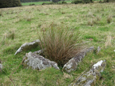
Chittaford Down Platform Cairn Circle
OS Map: SX 63502 79203
HER: MDV5832
Megalithic Portal: 42726
PMD: Archerton
Alternate name: Chittaford Down 1 Platform Cairn Circle
ShortName: PC Chittaford1
Butler map: 27.18.1
Butler Vol 5: p.170 & Fig.109
Grinsell: LYD 38
Turner: E14
Notes: "Remains of a cairn, visible as a turf covered stony mound. The NE quadrant is robbed out but around the rest of the periphery are parts of a kerb of small boulders, some set on edge, giving a diameter of 6.5m NW-SE. Maximum height 0.6m in the SW quadrant, but elsewhere the interior is badly robbed." Butler says there is a possible end slab of a cist.
Nearby sites: SX 63502 79203
Distance: 1.66km
Chittaford Down Platform Cairn Circle and Cist
OS Map: SX 63687 79463
HER: MDV5932
Megalithic Portal: 52177
PMD: Chittaford Down
Alternate name: Chittaford Down 3 Platform Cairn Circle and Cist
ShortName: CT Chittaford3
Butler map: 27.18.3
Butler Vol 5: p.160 & Fig.100
DPD page: 112
Grinsell: LYD 39
Turner: E28
Barrow Report: 57
Notes: "A cist about 350 yards north of Archerton House. It has an irregular shape no coverstone and stands in the centre of a 14ft. diameter ruined cairn. There are traces of an enclosing ring of stones. Excavation in 1900 recovered wood charcoal and a worked flint flake from a small pit within the cist. Under the eastern side stone an archer's polished stone wrist guard was found". Lethbridge diagram and photo bottom p.112. Butler Chittaford Down 3 - Vol. 2. Map 27.18 (diagram Vol. 5. p.160).
Nearby sites: SX 63687 79463
Distance: 1.94km
Crow Tor Platform Cairn Circle and Cist
OS Map: SX 60531 78683
HER: MDV5938
Megalithic Portal: 45775
PMD: Crow Tor
ShortName: CT Crow Tor
Butler map: 29.18
Butler Vol 5: p.196 & Fig.139
DPD page: 109
Grinsell: LYD 41
Turner: E39
Notes: "A kerbed cairn and cist. The cairn consists of a stony, turf-covered mound, and measures 4.5m in diameter and 0.45m in height. There are traces of a retaining kerb of leaning, granite slabs to the northeast and south. The cist is set slightly to the north of the centre of the cairn. It is trapezoidal in shape, and measures 0.65m and 0.95m in length, 0.8m in width, and 0.5m in depth. The cover-stone, which is 0.9m long, 0.5m wide and 0.2m thick, is displaced and lies just to the south east of the cist." Lethbridge diagram p.107, photo bottom p.109. Butler Vol. 2. Map 29.18 (p.63, photo on p.124, diagram Vol. 5. p.196).
Nearby sites: SX 60531 78683
Distance: 1.48km

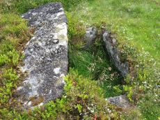
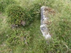
Higher White Tor Stone Row
OS Map: SX 61917 78362
HER: MDV5834
Megalithic Portal: 2192
The Stone Rows of GB: Higher White Tor
PMD: Higher White Tor Stone Row
ShortName: SR HigherWhite
Butler map: 29.16
DPD page: 110
Notes: "A Late Neolithic stone alignment on Higher White Tor, surviving as two parallel rows of stones aligned roughly north-south. The alignment is 95.4 metres long and contains twelve upright stones and 24 recumbent ones." Lethbridge diagram and photo p.110. Site visited 28/05/2025 by the author. The main photo above gives a more realistic picture than the more "artistic" second photo.
Nearby sites: SX 61917 78362
Distance: 0.16km
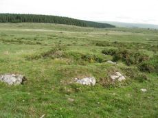
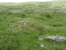
Stennen Hill No. 1 Platform Cairn Circle and Cist
OS Map: SX 62573 77905
HER: MDV5846
Megalithic Portal: 45736
PMD: Powder Mills W.
Alternate name: Stennen Hill 1 Platform Cairn Circle and Cist
ShortName: CT Stennen 1
Butler map: 29.11.1
Butler Vol 5: p.199 & Fig.142
DPD page: 111
Grinsell: LYD 47
Turner: E13
Barrow Report: 57
Notes: "Cist lies approximately in the centre of a subcircular cairn measuring 7 by 6.5m the longer axis and cist aligned nne to ssw. It is stony but almost turf-covered with 2 large kerbstones, including burnards `menhir' remaining in situ in the nw. The cist is flush with the cairn top, which is flattish and stands only 0.2m high on the nw but up to 0.7m high on the se, downhill side. This may be the cairn's original form; built into the slope as a flat platform with the cist visible (nmr citing pattison)". See also HER. Lethbridge photo top p.111. Butler Stennen Hill 1 - Vol. 2. Map 29.11 (diagram Vol. 5. p.199). NB. Worth & Grinsell name this Stennen Hill No. 1. Breton p.34.
Nearby sites: SX 62573 77905
Distance: 0.83km
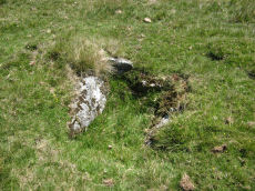
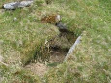
Stennen Hill No. 3 Cist
OS Map: SX 62615 77838
HER: MDV5847
Megalithic Portal: 45737
PMD: Powder Mills E.
Alternate name: Stennen Hill 2 Cist
ShortName: CT Stennen 2
Butler map: 29.11.2
Butler Vol 5: p.200 & Fig.143
DPD page: 111
Grinsell: LYD 49
Barrow Report: 57
Notes: "cist is oriented nw. - se. And is open with the south west side stone and the end stone buried beneath the turf. Internal dimensions 1.3m by 0.85m depth 0.5m. The mound, which is slight with a height of 0.3m is much disturbed. Judging by the remains of the retaining circle of which six stones can be seen the diameter of the mound was 4.5m. Condition of the cist is fair, of mound poor." Only one large stone remains in the mound of a cairn. Lethbridge photo top p.111. Butler Stennen Hill 2 - Vol. 2. Map 29.11 (diagram Vol. 5. p.200). NB. Worth & Grinsell name this Stennen Hill No. 3 (It is Butler 2). Breton p.34.
Nearby sites: SX 62615 77838
Distance: 0.90km
Wistman's wood Settlement
OS Map: SX 6125 7750
HER: MDV5933
Megalithic Portal: 42854
Alternate name: Wistman's wood Settlement
ShortName: ST:Wistmans
Nearby sites: SX 6125 7750
Distance: 1.25km