
Prehistoric sites within 2km of SX 58600 62600
Guidance for walkers: The monuments featured in this database are archaeological treasures and need to be protected and preserved - please do not disturb any sites. Please check access and firing times before visiting sites, not all sites listed are on open access land. Firing ranges and boundaries of open access areas are marked on the OL28 OS Dartmoor Explorer map. Please stick to the country code and consider giving support to the numerous agencies that help to keep Dartmoor a fabulous natural and historic environment!
About the database listings: In all listings clicking on the photo or the site name will open a page for the site with a larger photo and further details from the database. The database now has over 6680 records covering nearly all publicly listed sites on Dartmoor including around 4800 round houses. This level of detail is of interest to archaeologists but tends to swamp listings of sites more likely to be of interest for walkers. For this reason, the listings default to around 550 core sites only. These are the stone circles, stone rows and the ring cairns listed by Turner. The default search radius is 2 km. The controls below the map can be used to start a new search by entering a 6- or 8-digit reference (without the prefix "SX"). The search radius can be specified and you can add incremental Display layers of detail on top of the core sites. If using a more detailed layer you will need to decrease the search radius to avoid getting hundreds of search results.
- Core sites Default listing of core sites consisting of stone circles & rows and some of the major ring cairns.
- Plus cairns adds approx. 1000 cairns and other minor sites not included in the core listings but excluding round houses.
- Plus round houses adds approx. 4800 round houses.
- Plus non-sites adds in the records for sites that no longer exist or are not prehistoric sites.
- Plus duplicates adds records excluded as duplicates. Those maybe duplicate records in external listings (e.g. the Historic Environment Records). For example, some sites have been identified as cairns in some listings and interpreted as round houses in other listings and both records appear.
These listings have incorporated, matched up and merged all of the records from all of the major archaeological listings including: Worth, Grinsell, Turner, Butler, Bill Radcliffe, Sandy Gerrard, Megalithic Portal, the National Monument Records and the Historic Environment Records. The author would like to thank Bill, Sandy, the lovely people both at Megalithic Portal (especially Anne Tate who did an amazing job to link listings) and at ACE Archaeology for collaborative work over the years to synchronise and correct listings across the various websites which now interlink. A culmination of years of work the final merger of cairn records took 3 months of cross referencing in 2017 the result being a snapshot of the records at that time. This data has in turn been refined since by field work and research. The round house data was supplied by Sandy Gerrard. Grid references are in order of accuracy: from Google Earth satellite, if visible and found, from a Garmin GPS reading, if visited by the author and from the literature otherwise. Individual site pages will state the source of the grid reference and provide satellite imagery. If a site listing lacks a photo it has not yet been visited by the author in which case the grid reference is from the literature.
Currently the database only includes sites which can be represented by a grid reference. Reaves are not included as they require GIS shape technology which is beyond the current capability of this system. To see the sources for the records, look at the tables on the resources menu. The database listings can also be viewed on a Google map and downloaded as GPS datasets for Garmin devices.
Corrections, or any feedback or suggestions are very welcome, email: info@dartmoorwalks.org.uk.
NOTE: Clicking on the icons for each monument in the map will give the name of the site. You can zoom in and out and drag the map around.
List of sites within 2km of SX 58600 62600
Cholwichtown Contour Reave Enclosed Settlement
OS Map: SX 59383 63449
HER: MDV2435
ShortName: ST:Cholwich
Notes: Enclosure with hut circles on Cholwich Town contour reave.
Nearby sites: SX 59383 63449
Distance: 1.15km
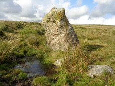
Hanging Stone Standing Stone
OS Map: SX 58372 63688
HER: MDV2423
Megalithic Portal: 45568
The Stone Rows of GB: Lee Moor South
PMD: The Hanging Stone
Alternate name: The Hanging Stone Standing Stone
ShortName: SS Hanging
Butler Vol 5: p.53
DPD page: 59
Notes: Located on Lee Moor. "The 'Hanging Stone' or 'Leaning Rock', 7ft 9ins in length, but because of the stone being 38o out of the vertical, its vertical height is only 6ft 9ins. It measures 3ft 7ins by 1ft 10ins at the base, and is incised on one face with the letters "CB" showing that at one time it was used as a bound-post. It is believed to be prehistoric." TDA Vol. 72 1940 pp. 192-3 (R Hansford Worth). See also, Legendary Dartmoor: The Hanging Stone.
Nearby sites: SX 58372 63688
Distance: 1.11km
High-house Waste Enclosed Settlement
OS Map: SX 605 627
HER: MDV4362
Megalithic Portal: 45579
ShortName: ES:HighHouse
DPD page: 63
Notes: "Scattered settlement of at least 12 circular huts, some of them being very large. Possibly Romano-British as opposed to the Bronze Age/Iron Age settlements nearby. Later rectangular house on south edge of area". Lethbridge p.63-64 Hut Circle with largest door jambs (over 4 foot tall) on Dartmoor.
Nearby sites: SX 605 627
Distance: 1.90km
Lee Moor (Upper Spanish Lake) Cist
OS Map: SX 58549 64450
HER: MDV2495
Megalithic Portal: 45753
PMD: Lee Moor
Alternate name: Upper Spanish Lake 3 Cist
ShortName: CT U Spanish 3
Butler map: 51.5.3
DPD page: 54
Grinsell: SHA 31
Barrow Report: 63
Notes: Part of a group of cairns very close together, see also NMR record SX56 SE4. "A small round cairn, 5.0m. diameter and 0.5m. high, on a gentle, well drained, clitter strewn, west facing slope at 355m. above OD. It is built of small boulders, now turf covered, and a cist lies within the cairn on the south-east side. The cist comprises the side and end stones, measures internally 0.7m. by 0.6m. wide, and is aligned on a grid bearing of 130o. The cover-stone is missing". Lethbridge p.54 Spanish Lake Cist. Butler Upper Spanish Lake 3 (Cairn 3) - Vol. 3. Map 51.5 (pp.162-4 general plan of Upper Spanish Lake huts and cairns p.163, diagram of cist p.164).
Nearby sites: SX 58549 64450
Distance: 1.85km
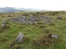
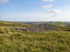
Penn Beacon Platform Cairn Circle
OS Map: SX 59827 62268
HER: MDV2402
Megalithic Portal: 45617
PMD: Penn Beacon 2
Alternate name: Penn Beacon S.2 Platform Cairn Circle
ShortName: PC:Penn Beac 2
Butler map: 52.14.2
Grinsell: COR 4
Turner: E7
Notes: A tumulus with a retaining circle, in poor condition. Diameter 12m, height 0.5m. "A cairn, about forty feet in diameter, from which almost all the stones have been removed and the central cist destroyed. It was surrounded by a circle of upright stones from one to three feet high, and to the west a row of two pairs of stones."
Nearby sites: SX 59827 62268
Distance: 1.27km
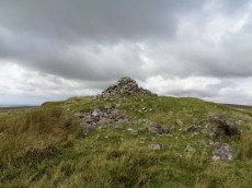
Penn Beacon Cairn
OS Map: SX 59924 62928
HER: MDV2404
Megalithic Portal: 45853
Alternate name: Penn Beacon Summit Cairn
ShortName: CN PennBeacon
Butler map: 52.14
Butler Vol 5: p.157 & Fig.96
Grinsell: COR 2
Barrow Report: 14
Notes: "A round cairn, 22 metres in diameter and 1.7 metres high, lies on the summit of Penn Beacon, at 430 metres above O.D. It is of small boulders and has been much disturbed, with a central hollow, 8 metres in diameter and 0.8 metres deep, and a modern marker cairn, 1 metre high, on the south side". Lethbridge p.62-3 suggests possible ruins of chambered cairn (diagram p.59).
Nearby sites: SX 59924 62928
Distance: 1.36km
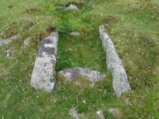
Penn Beacon 1 Cairn Circle & Cist
OS Map: SX 59532 62482
HER: MDV12909
PMD: Penn Beacon 1
Alternate name: Penn Beacon 1 stone row Cairn Circle & Cist
ShortName: CT Penn Beac 1
Butler map: 52.14.1
DPD page: 61
Grinsell: COR 3
Notes: A cairn on the lower slope of Penn Beacon, close to stone row (sx56se/2). Opened in 1872 by Spence Bate and Oliver: a fine cist was found, a stone implement and many pot fragments, one quite substantial. The cairn stands at the north end of a double stone row which extends for 7.0m. The cist is not visible. See also: Bate's 1872 Report
Nearby sites: SX 59532 62482
Distance: 0.94km
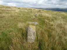
Penn Beacon S. Stone Row
OS Map: SX 59947 62553
HER: MDV2400
Megalithic Portal: 2076
The Stone Rows of GB: Penn Beacon South
PMD: Penn Beacon Stone Row
Alternate name: Penn Beacon S Stone Row
ShortName: SR Penn Beac S
Butler map: 52.14
DPD page: 62
Notes: "A single stone row, sixty-six feet long, the largest stone being about 2 1/2 feet high. This row is no more than a remnant". Lethbridge p.62 Penn stone row - diagram p.59.
Nearby sites: SX 59947 62553
Distance: 1.35km

Penn Beacon S.W. Stone Row
OS Map: SX 59523 62471
HER: MDV2399
Megalithic Portal: 2077
The Stone Rows of GB: Penn Beacon South West
PMD: Penn Beacon Cairn Stone Row
Alternate name: Penn Beacon SW Stone Row
ShortName: SR PennBeac SW
Butler map: 52.14.1
DPD page: 61
Notes: "A short double stone row 24ft. long and nearly 2ft. wide consisting of two pairs of stones on the southern slope of Penn Beacon. To the north end of the row there is a cairn approximately 52 feet in diameter and 6 foot high. It was excavated in 1872, a cist was discovered, though the capstone had collapsed at one end. Fragments of a wide mouthed jar were found and a slate implement, thought to be used for fashioning clay vessels". Lethbridge p.61 Penn Moor south double stone row and cairn - diagram p.59. See also: Bate's 1872 Report
Nearby sites: SX 59523 62471
Distance: 0.93km
Rook Tor Cairn Circle
OS Map: SX 6023 6153
HER: MDV132245
Megalithic Portal: 3445
Alternate name: Rook Tor 2 Cairn Circle
ShortName: CC:Rook Tor 2
Butler map: 52.8
Notes: Butler refers to a possible cairn at SX 6023 6153 a semi-circle of slabs amongst the rocks of Rook Tor are obviously artificially set - remains suggest the site of a cairn, entirely demolished but for the retaining circle. (Butler Vol. 3. p.182).
Turner lists a Rook Tor site (G21) 1km away at SX 6127 6148: 10 stones standing, one a boulder. Are there two seprate features or does one auth have the wrong grid reference? See also: Rook Tor 1
Nearby sites: SX 6023 6153
Distance: 1.95km
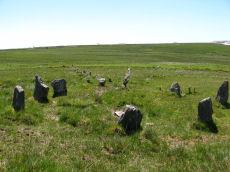
Shell Top Stone Ring Cairn Circle
OS Map: SX 59835 63835
HER: MDV12790
Megalithic Portal: 1250
Alternate name: Shell Top Summit 3 Stone Ring Cairn Circle
ShortName: RC:ShellTopSu3
Butler map: 51.10.3
Grinsell: COR 1a
Turner: A44
Notes: "A stone ring 20.5m overall diameter, comprising small, heather covered stones, 0.8m wide and 0.2m high. It lies on the broad level summit of shell top at 475m above sea level. There is a wide 3m wide gap on the north side and the interior is slightly domed, about 0.4m high, possibly a natural rise since it is off-centre. The term 'stone circle' is rather a mis-nomer since only half a dozen stones protrude from the turf and in appearance it is simply a low circular bank."
Nearby sites: SX 59835 63835
Distance: 1.75km
Shell Top Platform Cairn Circle
OS Map: SX 59766 63805
HER: MDV12905
Megalithic Portal: 45646
PMD: Shell Top
Alternate name: Shell Top Summit 1 Platform Cairn Circle
ShortName: PC:ShellTopSu1
Butler map: 51.10.1
Grinsell: COR 1
Turner: E53
Notes: Cairn 9.5m in diameter with boulder of tor. Butler Vol 3 map 51.10 p.174.
Nearby sites: SX 59766 63805
Distance: 1.68km
Shell Top Chambered Cairn
OS Map: SX 58690 63517
HER: MDV2411
Megalithic Portal: 45852
Alternate name: Tory Brookhead 3 Chambered Cairn
ShortName: CN ToryBrook 3
Butler map: 51.7.3
DPD page: 59
Grinsell: SHA 39
Notes: "A Bronze Age round cairn on a well drained south west facing slope. The cairn mound measures 26 metres by 24 metres and stands up to 1.2 metres high. The centre is much disturbed, with many hollows, up to 1m deep, which have been interpreted as chambers, but are most probably modern windbreak shelters. Two small satellite cairns lie immediately to the north west." Lethbridge suggests a chambered cairn, see photos Lethbridge p.59-60 Chambered Cairn - diagram p.59
Nearby sites: SX 58690 63517
Distance: 0.92km
Shell Top S.W. Stone Row
OS Map: SX 59473 63142
HER: MDV48897
Megalithic Portal: 36955
The Stone Rows of GB: Shell Top South West
PMD: Shell Top Stone Row
Alternate name: Shell Top SW Stone Row
ShortName: SR:ShellTopSW
Butler map: 51.9
DPD page: 60
Notes: Not listed in NMR. Discovered by Lethbridge in 1992. Butler Vol. 3 Map 51.9. Oval cairn at the higher end. Orientated just west of north and 73.5 m from the cairn is a massive fallen longstone 2.7 m long which is probably the terminal stone of the row. There are 31 of 47 original stones visible in the row, all but a few either flat or leaning. Lethbridge p.59-61 diagram p.59, 61.
Nearby sites: SX 59473 63142
Distance: 1.03km
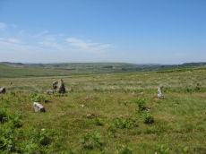
South-west of Penn Beacon Enclosed Settlement
OS Map: SX 59763 62760
HER: MDV2401
ShortName: ST:Penn BeacSW
Notes: Enclosure with hut circles on Cholwich Town contour reave.
Nearby sites: SX 59763 62760
Distance: 1.17km
Trowlesworthy E. Stone Row
Prehistoric Dartmoor Walks: Dartmoor Site: Trowlesworthy, Settlements, Stone Row & Cairn Circle
OS Map: SX 57646 63972
HER: MDV2421
Megalithic Portal: 3516
The Stone Rows of GB: Trowlesworthy 1
PMD: Trowlesworthy E Stone Row
Alternate name: Trowlesworthy 1 Stone Row
ShortName: SR Trowles E
Butler map: 51.8.1
Butler Vol 5: p.229 & Fig.163
DPD page: 57
Notes: Butler Trowlesworthy 1. "A Bronze Age stone alignment comprising a double stone row consisting of 99 upright and 8 recumbent stones running south-south-west from a possible stone circle near the foot of the south flank of Little Trowlesworthy Tor. The surviving length of the row is about 129 metres, it is bisected by a leat. The better preserved element of the row is down the slope from the leat. The circle comprises 8 main orthostat stones in a "kidney-shaped" plan. The south-west orthostat in the ring is surrounded by a number of smaller stones". Lethbridge p.57-8, diagram p.58. See also, Legendary Dartmoor: The Pulpit and Sea Views at Trowlesworthy 1
Nearby sites: SX 57646 63972
Distance: 1.67km
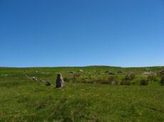
Trowlesworthy W. Stone Row
Prehistoric Dartmoor Walks: Dartmoor Site: Trowlesworthy, Settlements, Stone Row & Cairn Circle
OS Map: SX 57536 63978
HER: MDV2415
Megalithic Portal: 2176
The Stone Rows of GB: Trowlesworthy 2
PMD: Trowlesworthy W Stone Row
Alternate name: Trowlesworthy 2 Stone Row
ShortName: SR Trowles W
Butler map: 51.8.2
DPD page: 58
Notes: Butler Trowlesworthy 2. "A single stone row consisting of 35 upright and 13 recumbent stones running in an E to W line from the site of a possible ring cairn at the foot of the SW flank of Little Trowlesworthy Tor. The cairn at the head of the row is marked by a circle containing one upright and eight fallen small slabs and boulders. Within these is a slightly raised area, perhaps the remains of a cairn." Lethbridge p.57-8, diagram p.58.
Nearby sites: SX 57536 63978
Distance: 1.74km
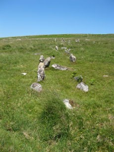
Trowlesworthy Warren (E) Cairn Circle
Prehistoric Dartmoor Walks: Dartmoor Site: Trowlesworthy, Settlements, Stone Row & Cairn Circle
OS Map: SX 57651 63983
HER: MDV49511
Megalithic Portal: 529
PMD: Trowlesworthy E Stone Row
Alternate name: Trowlesworthy stone row 1 Cairn Circle
ShortName: CC Trowles E
Butler map: 51.8.1
Butler Vol 5: p.229 & Fig.163
DPD page: 58
Grinsell: SHA 44
Turner: G25
Notes: Cairn circle at head of stone row. "The circle 6.5m. in diameter comprises eight orthostats from 0.7m. to 1.5m. high. In some cases the 'trig' stones are visible." "The alleged cairn at the head of the row comprises a ring of eight stones a maximum of 1.2m high with no evidence of a cist and very little to suggest the former presence of a cairn. It would seem more likely to represent the remains of a small stone circle albeit only 6.0 to 6.5m in diameter." See also, Legendary Dartmoor: The Pulpit. Lethbridge p.57-8, diagram p.58.
Nearby sites: SX 57651 63983
Distance: 1.68km
Trowlesworthy Warren (W) Cairn Circle
Prehistoric Dartmoor Walks: Dartmoor Site: Trowlesworthy, Settlements, Stone Row & Cairn Circle
OS Map: SX 57544 63986
HER: MDV49509
Megalithic Portal: 3517
PMD: Trowlesworthy W Stone Row
Alternate name: Trowlesworthy stone row 2 Cairn Circle
ShortName: CC Trowles W
Butler map: 51.8.2
Grinsell: SHA 43
Turner: G26
Notes: This is a cairn circle at the east end of the Trowlesworthy Warren (W) stone row. "At the east is a 4.5m. diameter circle of 10 stones; average height 0.4m. There is no visible cairn or cist in the centre. Two upright stones immediately to the north west of the circle are probably associated. "
Nearby sites: SX 57544 63986
Distance: 1.74km