
Lee Moor (Upper Spanish Lake) Cist
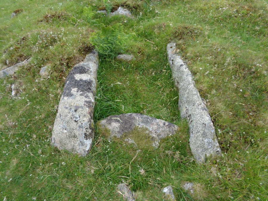
Photo taken on 23-06-2017
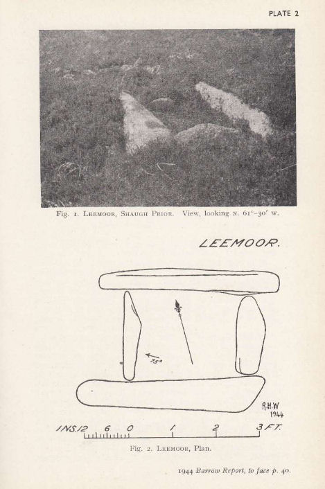
Plan by RHW. Barrow Report 63. TDA Vol.76 1944
Database entries
OS Map: SX 58549 64450
OS Source: Garmin
Butler OS: SX58556445
HER: MDV2495
Megalithic Portal: 45753
PMD: Lee Moor
Alternate name: Upper Spanish Lake 3
Short Name: CT U Spanish 3
Butler map: 51.5.3
Dixon Cist #: 89
Grinsell: SHAUGH PRIOR 31
DPD page: 54
Exist: Yes
Record: Unique
Record Source: Butler
Hut Class: No
Cist Class: Yes
Cairn Class: Yes
Barrow Report: 63
Dimensions (m): 5.0 x 0.5 C
Lidar: SX 58549 64450
Guide Map: 53
Nearest Bus Stop: Lee Moor Clearview (3.8 km) [Route: 59]
Nearby sites: SX 58549 64450
Notes
Part of a group of cairns very close together, see also NMR record SX56 SE4. "A small round cairn, 5.0m. diameter and 0.5m. high, on a gentle, well drained, clitter strewn, west facing slope at 355m. above OD. It is built of small boulders, now turf covered, and a cist lies within the cairn on the south-east side. The cist comprises the side and end stones, measures internally 0.7m. by 0.6m. wide, and is aligned on a grid bearing of 130o. The cover-stone is missing". Lethbridge p.54 Spanish Lake Cist. Butler Upper Spanish Lake 3 (Cairn 3) - Vol. 3. Map 51.5 (pp.162-4 general plan of Upper Spanish Lake huts and cairns p.163, diagram of cist p.164).References
These are selected references with an emphasis on out of copyright sources linked as PDFs. For more detailed references try any linked HER or PMD record above.
- Butler, Jeremy, Dartmoor Atlas of Antiquities, vol.3: The South-West, (1994)
- Gerrard, Sandy, English Heritage Book of Dartmoor: Landscapes Through Time, (1997)
- Grinsell, L.V., Dartmoor Barrows, Devon Archaeological Society Proceedings No.36 (1978)
- Lethbridge, William D., Discover Preshistoric Dartmoor, (2015)
- Worth, R. Hansford, Barrow Report 63, T.D.A. Vol.76 pp.39-40 (1944)