
Prehistoric sites within 3km of SX 53180 84000
Guidance for walkers: The monuments featured in this database are archaeological treasures and need to be protected and preserved - please do not disturb any sites. Please check access and firing times before visiting sites, not all sites listed are on open access land. Firing ranges and boundaries of open access areas are marked on the OL28 OS Dartmoor Explorer map. Please stick to the country code and consider giving support to the numerous agencies that help to keep Dartmoor a fabulous natural and historic environment!
About the database listings: In all listings clicking on the photo or the site name will open a page for the site with a larger photo and further details from the database. The database now has over 6680 records covering nearly all publicly listed sites on Dartmoor including around 4800 round houses. This level of detail is of interest to archaeologists but tends to swamp listings of sites more likely to be of interest for walkers. For this reason, the listings default to around 550 core sites only. These are the stone circles, stone rows and the ring cairns listed by Turner. The default search radius is 2 km. The controls below the map can be used to start a new search by entering a 6- or 8-digit reference (without the prefix "SX"). The search radius can be specified and you can add incremental Display layers of detail on top of the core sites. If using a more detailed layer you will need to decrease the search radius to avoid getting hundreds of search results.
- Core sites Default listing of core sites consisting of stone circles & rows and some of the major ring cairns.
- Plus cairns adds approx. 1000 cairns and other minor sites not included in the core listings but excluding round houses.
- Plus round houses adds approx. 4800 round houses.
- Plus non-sites adds in the records for sites that no longer exist or are not prehistoric sites.
- Plus duplicates adds records excluded as duplicates. Those maybe duplicate records in external listings (e.g. the Historic Environment Records). For example, some sites have been identified as cairns in some listings and interpreted as round houses in other listings and both records appear.
These listings have incorporated, matched up and merged all of the records from all of the major archaeological listings including: Worth, Grinsell, Turner, Butler, Bill Radcliffe, Sandy Gerrard, Megalithic Portal, the National Monument Records and the Historic Environment Records. The author would like to thank Bill, Sandy, the lovely people both at Megalithic Portal (especially Anne Tate who did an amazing job to link listings) and at ACE Archaeology for collaborative work over the years to synchronise and correct listings across the various websites which now interlink. A culmination of years of work the final merger of cairn records took 3 months of cross referencing in 2017 the result being a snapshot of the records at that time. This data has in turn been refined since by field work and research. The round house data was supplied by Sandy Gerrard. Grid references are in order of accuracy: from Google Earth satellite, if visible and found, from a Garmin GPS reading, if visited by the author and from the literature otherwise. Individual site pages will state the source of the grid reference and provide satellite imagery. If a site listing lacks a photo it has not yet been visited by the author in which case the grid reference is from the literature.
Currently the database only includes sites which can be represented by a grid reference. Reaves are not included as they require GIS shape technology which is beyond the current capability of this system. To see the sources for the records, look at the tables on the resources menu. The database listings can also be viewed on a Google map and downloaded as GPS datasets for Garmin devices.
Corrections, or any feedback or suggestions are very welcome, email: info@dartmoorwalks.org.uk.
NOTE: Clicking on the icons for each monument in the map will give the name of the site. You can zoom in and out and drag the map around.
List of sites within 3km of SX 53180 84000
Gallows Hill Cairn
OS Map: SX 51204 85223
HER: MDV4646
ShortName: CN:Gallows H1
Grinsell: LYD 3
Nearby sites: SX 51204 85223
Distance: 2.32km
Rattlebrook Foot Round House
OS Map: SX 5588 8384
HER: MDV50747
ShortName: HT:Rattlebro1
Nearby sites: SX 5588 8384
Distance: 2.70km
Rattlebrook Foot Round House
OS Map: SX 5585 8386
HER: MDV50746
ShortName: HT:Rattlebro2
Nearby sites: SX 5585 8386
Distance: 2.67km
Rattlebrook Foot Round House
OS Map: SX 5593 8388
HER: MDV3306
ShortName: HT:Rattlebro3
Nearby sites: SX 5593 8388
Distance: 2.75km
Rattlebrook Foot Round House
OS Map: SX 5589 8387
HER: MDV3308
ShortName: HT:Rattlebro4
Nearby sites: SX 5589 8387
Distance: 2.71km
Rattlebrook Foot Round House
OS Map: SX 559 839
HER: MDV50748
ShortName: HT:Rattlebro5
Nearby sites: SX 559 839
Distance: 2.72km
Rattlebrook Foot Round House
OS Map: SX 5590 8384
HER: MDV50749
ShortName: HT:Rattlebro6
Nearby sites: SX 5590 8384
Distance: 2.72km
Rattlebrook Foot Round House
OS Map: SX 5591 8384
HER: MDV50750
ShortName: HT:Rattlebro7
Nearby sites: SX 5591 8384
Distance: 2.73km
White Hill S.E. Cairn
OS Map: SX 5346 8375
HER: MDV46586
ShortName: CN:WhiteHiSE
Nearby sites: SX 5346 8375
Distance: 0.38km
Nattor Down 7 Cairn
OS Map: SX 5390 8352
HER: MDV50682
ShortName: CN:Nattor 7
Nearby sites: SX 5390 8352
Distance: 0.87km
White Hill N.E.10 Cairn
OS Map: SX 53555 84004
HER: MDV51452
ShortName: CN:WhiteHiNE10
Nearby sites: SX 53555 84004
Distance: 0.38km
Great Nodden 1 Cairn Circle
Prehistoric Dartmoor Walks: Dartmoor Site: Guide to the Cairns on Great Nodden
OS Map: SX 53079 86222
ShortName: CN Great Nod 1
Butler map: 43.7.1
Notes: This site originates with Butler but is not listed elsewhere. A mound can be seen on Lidar imagery at SX 53077 86213 which matches the location given by Butler. Visited 3 June 2022 and there is clearly a substantial but badly damaged cairn at this location. It can also be seen on Google satellite imagery. Whether it is prehistoric or later clearance is hard to say but the mutilated state suggests maybe more likely a robbed out prehistoric cairn. The Great Nodden Cairns 1-3 are not listed on the HER but there is an entry for the field system which states "May include some cairns, which presumably may be clearance cairns". See HER record Field system south of Nodden Gate MDV27320.
Nearby sites: SX 53079 86222
Distance: 2.22km
Great Nodden 2 Cairn
Prehistoric Dartmoor Walks: Dartmoor Site: Guide to the Cairns on Great Nodden
OS Map: SX 53101 86256
ShortName: CN Great Nod 2
Butler map: 43.7.2
Notes: This site originates with Butler but is not listed elsewhere. A mound can be seen on Lidar imagery at SX 53098 86249 which matches the location given by Butler. Butler: "two smaller and much pitted cairns 5 and 6 m across lie close to the field wall." Visited 3 June 2022. This was previously listed as a "reported cairn", this has now been updated to "cairn". It looks a genuine site to the author. NGR and photo updated after visit 28 April 2023. The Great Nodden Cairns 1-3 are not listed on the HER but there is an entry for the field system which states "May include some cairns, which presumably may be clearance cairns". See HER record Field system south of Nodden Gate MDV27320.
Nearby sites: SX 53101 86256
Distance: 2.26km
Great Nodden 3 Cairn
Prehistoric Dartmoor Walks: Dartmoor Site: Guide to the Cairns on Great Nodden
OS Map: SX 53078 86287
ShortName: CN Great Nod 3
Butler map: 43.7.3
Notes: This site originates with Butler but is not listed elsewhere. A mound can be seen on Lidar imagery at SX 53073 86276 which matches the location given by Butler.Butler: "two smaller and much pitted cairns 5 and 6 m across lie close to the field wall". This was previously listed as a "reported cairn", this has now been updated to "cairn". It looks a genuine site to the author. The Great Nodden Cairns 1-3 are not listed on the HER but there is an entry for the field system which states "May include some cairns, which presumably may be clearance cairns". See HER record Field system south of Nodden Gate MDV27320.
Nearby sites: SX 53078 86287
Distance: 2.29km
Great Nodden 4 Cairn
Prehistoric Dartmoor Walks: Dartmoor Site: Guide to the Cairns on Great Nodden
OS Map: SX 53249 86629
HER: MDV51450
ShortName: CN Great Nod 4
Butler map: 43.7.4
Notes: Ring cairn. "Earthwork survives as a circular bank, 2.3m wide and 0.3m high surrounding an internal area measuring 13.4m in diameter. A mound measuring 6m in diam and 0.2m high stands in the centre of the area enclosed by the circular bank (mpp)". The grid reference given by Butler is a rare mistake. The Butler 43 map and the description make it clear the site is actually located in the vicinity of SX 5324 8660 which is around 400m north the grid reference given on p.245. This corrected grid reference corresponds with the cairn listed here. Visit on 20/06/22 resulted in the photo used. Follow up visit 28/04/23 - found again with difficulty despite having correct grid reference. Not easy to see in the vegetation but it is clearly there and for that reason the entry has been changed from reported cairn to cairn.
Nearby sites: SX 53249 86629
Distance: 2.63km
Great Nodden 5 Cairn
Prehistoric Dartmoor Walks: Dartmoor Site: Guide to the Cairns on Great Nodden
OS Map: SX 53343 86810
HER: MDV51448
ShortName: CN Great Nod 5
Butler map: 43.7.5
Notes: Group of 6 small cairns. This clear mound is not far from Great Nodden 6. NGR from Garmin reading taken 28/04/23. "One of two Bronze Age round cairns south-west of Great Nodden. Cairn mound is flat-topped, measures 5m in diameter and stands up to 0.6m high"
Nearby sites: SX 53343 86810
Distance: 2.81km
Great Nodden 6 Cairn
Prehistoric Dartmoor Walks: Dartmoor Site: Guide to the Cairns on Great Nodden
OS Map: SX 53340 86820
HER: MDV51449
ShortName: CN Great Nod 6
Butler map: 43.7.6
Notes: Group of 6 small cairns. These 6 small cairns are quite difficult to find in the undergrowth especially when original NGRs were inaccurate. Visited 03/06/22 and 28/04/23. NGR has been updated with an accurate Garmin reading. Very clear mound for this cairn.
Nearby sites: SX 53340 86820
Distance: 2.82km
Great Nodden 7 Cairn
Prehistoric Dartmoor Walks: Dartmoor Site: Guide to the Cairns on Great Nodden
OS Map: SX 53337 86887
HER: MDV51447
ShortName: CN Great Nod 7
Butler map: 43.7.7
Notes: Group of 6 small cairns. Visited on 03/06/22 and 28/04/23. NGR and details confirmed on 28/04/23.
Nearby sites: SX 53337 86887
Distance: 2.89km
Cholwell (N.E of, Site of) Reported Cairn
OS Map: SX 515 820
HER: MDV20154
ShortName: CN:Cholwell 1
Grinsell: MAR 3
Notes: Grinsell could find no sign of cairns in August 1976
Nearby sites: SX 515 820
Distance: 2.61km
Great Nodden 8 Cairn
Prehistoric Dartmoor Walks: Dartmoor Site: Guide to the Cairns on Great Nodden
OS Map: SX 5339 8689
HER: MDV51446
ShortName: CN Great Nod 8
Butler map: 43.7.8
Notes: Group of 6 small cairns
Nearby sites: SX 5339 8689
Distance: 2.90km
Great Nodden 9 Cairn
Prehistoric Dartmoor Walks: Dartmoor Site: Guide to the Cairns on Great Nodden
OS Map: SX 5340 8691
HER: MDV51507
ShortName: CN:Great Nod 9
Butler map: 43.7.9
Notes: Group of 6 small cairns. Not found on 03/06/22, 20/06/22 and 28/04/23. However, this is overgrown terrain with many clumps of vegetation looking like mounds. The NGRs for these 6 were often very inccurate in the original listings.
Nearby sites: SX 5340 8691
Distance: 2.92km

Great Nodden 10 Cairn
Prehistoric Dartmoor Walks: Dartmoor Site: Guide to the Cairns on Great Nodden
OS Map: SX 53370 86934
HER: MDV51445
ShortName: CN Great Nod10
Butler map: 43.7.10
Notes: Group of 6 small cairns. Visited 03/06/22 and again 28/04/23. "Round cairn. Mound measures 6m in diameter and stands up to 0.6m high. A 1.4m square stone filled hollow in the centre of the mound suggests partial early excavation or robbing."
Nearby sites: SX 53370 86934
Distance: 2.94km
White Hill (exc. 1888 PET 6a) Reported Cairn
OS Map: SX 5294 8360
HER: MDV57360
ShortName: CN:White Hil2
Grinsell: PET 6a
Barrow Report: 10
Notes: Source is 1888 account. LVG Could not find. Could the location be wrong? Radcliffe suggests this could be PET 3.
Nearby sites: SX 5294 8360
Distance: 0.47km
White Hill (PET 8) Cairn
OS Map: SX 53427 83853
HER: MDV3212
ShortName: CN:White Hil3
Grinsell: PET 8
Notes: NMR 440678 B. Ring cairn 50m north-east of White Hill summit forming part of the White Hill round cairn cemetery. Cairn survives as flat internal area, diameter 11 metres, surrounded by circular bank 2.3 metres wide by 0.15 metres high.
Nearby sites: SX 53427 83853
Distance: 0.29km
White Hill N.E.11 Cairn
OS Map: SX 5366 8405
HER: MDV57361
ShortName: CN:WhiteHiNE11
Nearby sites: SX 5366 8405
Distance: 0.48km
Watern Oke Round House
OS Map: SX 5616 8370
HER: MDV50159
ShortName: HT:WaternOk23
Nearby sites: SX 5616 8370
Distance: 3.00km
Watern Oke Round House
OS Map: SX 56156 83702
HER: MDV50158
ShortName: HT:WaternOk25
Nearby sites: SX 56156 83702
Distance: 2.99km
Watern Oke Round House
OS Map: SX 56110 83738
HER: MDV50166
ShortName: HT:WaternOk27
Nearby sites: SX 56110 83738
Distance: 2.94km
Sharp Tor Round House
OS Map: SX 54705 84875
HER: MDV51474
ShortName: HT:Sharp Tor1
Nearby sites: SX 54705 84875
Distance: 1.76km
Watern Oke Round House
OS Map: SX 56112 83735
HER: MDV50166
ShortName: HT:WaternOk28
Nearby sites: SX 56112 83735
Distance: 2.94km
Sharp Tor Round House
OS Map: SX 54709 84852
HER: MDV51477
ShortName: HT:Sharp Tor2
Nearby sites: SX 54709 84852
Distance: 1.75km
Sharp Tor Round House
OS Map: SX 54705 84899
HER: MDV51471
ShortName: HT:Sharp Tor3
Nearby sites: SX 54705 84899
Distance: 1.77km
Sharp Tor Round House
OS Map: SX 54687 84869
HER: MDV51480
ShortName: HT:Sharp Tor4
Nearby sites: SX 54687 84869
Distance: 1.74km
Sharp Tor Round House
OS Map: SX 54740 84881
HER: MDV51473
ShortName: HT:Sharp Tor5
Nearby sites: SX 54740 84881
Distance: 1.79km
Sharp Tor Round House
OS Map: SX 54687 84897
HER: MDV51470
ShortName: HT:Sharp Tor6
Nearby sites: SX 54687 84897
Distance: 1.75km
Sharp Tor Round House
OS Map: SX 54716 84857
HER: MDV51474
ShortName: HT:Sharp Tor7
Nearby sites: SX 54716 84857
Distance: 1.76km
Sharp Tor Round House
OS Map: SX 54677 84849
HER: MDV51479
ShortName: HT:Sharp Tor8
Nearby sites: SX 54677 84849
Distance: 1.72km
Sharp Tor Round House
OS Map: SX 54669 84892
HER: MDV51469
ShortName: HT:Sharp Tor9
Nearby sites: SX 54669 84892
Distance: 1.74km
Sharp Tor Round House
OS Map: SX 54718 84899
HER: MDV51472
ShortName: HT:Sharp Tor10
Nearby sites: SX 54718 84899
Distance: 1.78km
Sharp Tor Round House
OS Map: SX 54725 84860
HER: MDV51475
ShortName: HT:Sharp Tor11
Nearby sites: SX 54725 84860
Distance: 1.77km
Sharp Tor Round House
OS Map: SX 54647 84883
HER: MDV51468
ShortName: HT:Sharp Tor12
Nearby sites: SX 54647 84883
Distance: 1.71km
White Hill N.E.1 Cairn
OS Map: SX 53571 84035
HER: MDV51453
ShortName: CN:WhiteHiNE1
Nearby sites: SX 53571 84035
Distance: 0.39km
White Hill N.E.2 Cairn
OS Map: SX 53633 84046
HER: MDV51454
ShortName: CN:WhiteHiNE2
Nearby sites: SX 53633 84046
Distance: 0.46km
White Hill N.E.3 Cairn
OS Map: SX 53523 84078
HER: MDV51455
ShortName: CN:WhiteHiNE3
Nearby sites: SX 53523 84078
Distance: 0.35km
White Hill N.E.4 Cairn
OS Map: SX 53541 84080
HER: MDV51456
ShortName: CN:WhiteHiNE4
Nearby sites: SX 53541 84080
Distance: 0.37km
White Hill N.E.5 Cairn
OS Map: SX 5344 8405
HER: MDV51457
ShortName: CN:WhiteHiNE5
Nearby sites: SX 5344 8405
Distance: 0.26km
White Hill N.E.6 Cairn
OS Map: SX 53363 84013
HER: MDV51458
ShortName: CN:WhiteHiNE6
Nearby sites: SX 53363 84013
Distance: 0.18km
White Hill N.E.7 Cairn
OS Map: SX 53357 84023
HER: MDV51459
ShortName: CN:WhiteHiNE7
Nearby sites: SX 53357 84023
Distance: 0.18km
Dead Lake Foot Round House
OS Map: SX 5616 8421
HER: MDV50760
ShortName: HT:Dead Lake19
Nearby sites: SX 5616 8421
Distance: 2.99km
White Hill N.E.8 Cairn
OS Map: SX 53319 84004
HER: MDV51460
ShortName: CN:WhiteHiNE8
Nearby sites: SX 53319 84004
Distance: 0.14km
White Hill N.E.9 Cairn
OS Map: SX 53310 84007
HER: MDV51461
ShortName: CN:WhiteHiNE9
Nearby sites: SX 53310 84007
Distance: 0.13km
White Hill 14 Cairn
OS Map: SX 53006 83658
HER: MDV17699
ShortName: CN:White Hil6
Butler map: 32.22.14
Notes: The southern of three closely spaced round cairns, circa 4.5 metres diameter, 0.3 metres high. Grid refrence SX 53006 83658 is from Google Earth comparing with the other two cairns, it can't be seen so it is an estimate. The HER grid reference is a 14m to the south.
Nearby sites: SX 53006 83658
Distance: 0.38km
Dead Lake Foot Round House
OS Map: SX 5614 8422
HER: MDV50762
ShortName: HT:Dead Lake22
Nearby sites: SX 5614 8422
Distance: 2.97km
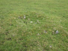
White Hill 15 Cairn
OS Map: SX 53088 83804
HER: MDV103628
ShortName: CN:White Hil7
Butler map: 32.22.15
Notes: Disturbed turf-covered cairn measuring 5.9 metres in diameter composed of sandstone and slate stones with a hollow centre.
Nearby sites: SX 53088 83804
Distance: 0.22km
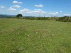
Bearwalls Farm (SE of) Cairn
OS Map: SX 5309 8406
HER: MDV78333
ShortName: CN:Bearwalls1
Notes: Indistinct cairn visible south-east of Bearwalls Farm.
Nearby sites: SX 5309 8406
Distance: 0.11km
Hamlyn's Newtake Round House
OS Map: SX 54074 83539
HER: MDV3215
ShortName: HT:Hamlyn's 1
Nearby sites: SX 54074 83539
Distance: 1.01km
White Hill W.1 Cairn
OS Map: SX 52604 83808
HER: MDV46981
ShortName: CN:WhiteHillW1
Nearby sites: SX 52604 83808
Distance: 0.61km
Dead Lake Foot Round House
OS Map: SX 5617 8424
HER: MDV50752
ShortName: HT:Dead Lake25
Nearby sites: SX 5617 8424
Distance: 3.00km
Hamlyn's Newtake Round House
OS Map: SX 54074 83552
HER: MDV3215
ShortName: HT:Hamlyn's 2
Nearby sites: SX 54074 83552
Distance: 1.00km
White Hill W.2 Cairn
OS Map: SX 52647 83808
HER: MDV46982
ShortName: CN:WhiteHillW2
Nearby sites: SX 52647 83808
Distance: 0.57km
Dead Lake Foot Round House
OS Map: SX 5610 8419
HER: MDV50766
ShortName: HT:Dead Lake26
Nearby sites: SX 5610 8419
Distance: 2.93km
Hamlyn's Newtake Round House
OS Map: SX 54084 83544
HER: MDV3215
ShortName: HT:Hamlyn's 3
Nearby sites: SX 54084 83544
Distance: 1.01km
White Hill W.3 Cairn
OS Map: SX 52556 83808
HER: MDV46983
ShortName: CN:WhiteHillW3
Nearby sites: SX 52556 83808
Distance: 0.65km
Hamlyn's Newtake Round House
OS Map: SX 54056 83559
HER: MDV3215
ShortName: HT:Hamlyn's 4
Nearby sites: SX 54056 83559
Distance: 0.98km
White Hill W.4 Cairn
OS Map: SX 52583 83794
HER: MDV46984
ShortName: CN:WhiteHillW4
Nearby sites: SX 52583 83794
Distance: 0.63km
Hamlyn's Newtake Round House
OS Map: SX 54085 83535
HER: MDV3215
ShortName: HT:Hamlyn's 5
Nearby sites: SX 54085 83535
Distance: 1.02km
Dead Lake Foot Round House
OS Map: SX 5614 8421
HER: MDV50761
ShortName: HT:Dead Lake29
Nearby sites: SX 5614 8421
Distance: 2.97km
Hamlyn's Newtake Round House
OS Map: SX 54063 83552
HER: MDV3215
ShortName: HT:Hamlyn's 6
Nearby sites: SX 54063 83552
Distance: 0.99km
Dead Lake Foot Round House
OS Map: SX 5610 8421
HER: MDV50764
ShortName: HT:Dead Lake30
Nearby sites: SX 5610 8421
Distance: 2.93km
Hamlyn's Newtake Round House
OS Map: SX 54186 83497
HER: MDV50683
ShortName: HT:Hamlyn's 7
Nearby sites: SX 54186 83497
Distance: 1.12km
Ger Tor 3 Reported Cairn
OS Map: SX 54569 83474
HER: MDV103474
ShortName: CN?Ger Tor 3
Notes: "Pair of cairns identified to the north of Ger Tor. The northernmost may prove to be of more modern origin." "Northern cairn consisting of a small irregular pile of boulders and stones up to 0.3 metres high located on a high point. It lies on a slight granite outcrop at SX54568349 and it overlooks Hamlyns Newtake. Of uncertain function it may have a relatively recent origin."
Nearby sites: SX 54569 83474
Distance: 1.49km
Highdown 2 Cairn
OS Map: SX 52760 85044
HER: MDV103576
ShortName: CN:Highdown 2
Nearby sites: SX 52760 85044
Distance: 1.13km
Dead Lake Foot Round House
OS Map: SX 5610 8418
HER: MDV50736
ShortName: HT:Dead Lake34
Nearby sites: SX 5610 8418
Distance: 2.93km
Nattor Down 8 Cairn
OS Map: SX 53690 82747
HER: MDV103593
ShortName: CN:Nattor 8
Nearby sites: SX 53690 82747
Distance: 1.35km
Nattor Down 9 Cairn
OS Map: SX 53837 82957
HER: MDV103595
ShortName: CN:Nattor 9
Nearby sites: SX 53837 82957
Distance: 1.23km
Arms Tor Round House
OS Map: SX 53559 86255
HER: MDV4635
ShortName: HT:Arms Tor1
Nearby sites: SX 53559 86255
Distance: 2.29km
Arms Tor Round House
OS Map: SX 5356 8631
HER: MDV50901
ShortName: HT:Arms Tor2
Nearby sites: SX 5356 8631
Distance: 2.34km
Arms Tor Round House
OS Map: SX 5360 8633
HER: MDV4643
ShortName: HT:Arms Tor3
Nearby sites: SX 5360 8633
Distance: 2.37km
Arms Tor Round House
OS Map: SX 53578 86257
HER: MDV50904
ShortName: HT:Arms Tor4
Nearby sites: SX 53578 86257
Distance: 2.29km
Arms Tor Round House
OS Map: SX 5385 8595
HER: MDV27323
ShortName: HT:Arms Tor5
Nearby sites: SX 5385 8595
Distance: 2.06km
Arms Tor Round House
OS Map: SX 5357 8633
HER: MDV4644
ShortName: HT:Arms Tor6
Nearby sites: SX 5357 8633
Distance: 2.36km
Arms Tor Round House
OS Map: SX 53563 86252
HER: MDV50900
ShortName: HT:Arms Tor7
Nearby sites: SX 53563 86252
Distance: 2.28km
Walla Brook Reported Cairn
OS Map: SX 54093 84344
HER: MDV103624
ShortName: CN?Walla Brook
Nearby sites: SX 54093 84344
Distance: 0.98km
Arms Tor Round House
OS Map: SX 5351 8618
HER: MDV4637
ShortName: HT:Arms Tor8
Nearby sites: SX 5351 8618
Distance: 2.20km
Arms Tor Round House
OS Map: SX 53586 86255
HER: MDV4634
ShortName: HT:Arms Tor9
Nearby sites: SX 53586 86255
Distance: 2.29km
Hare Tor N.3 Reported Cairn
OS Map: SX 55284 84574
HER: MDV103626
ShortName: CN?Hare Tor 3
Nearby sites: SX 55284 84574
Distance: 2.18km
Arms Tor Round House
OS Map: SX 5360 8622
HER: MDV4636
ShortName: HT:Arms Tor10
Nearby sites: SX 5360 8622
Distance: 2.26km
Arms Tor Round House
OS Map: SX 53615 86326
ShortName: HT:Arms Tor11
Nearby sites: SX 53615 86326
Distance: 2.37km
Tavy Cleave E Round House
OS Map: SX 55771 83235
ShortName: HT:Tavy Clea1
Nearby sites: SX 55771 83235
Distance: 2.70km
Arms Tor Round House
OS Map: SX 53617 86313
ShortName: HT:Arms Tor12
Nearby sites: SX 53617 86313
Distance: 2.35km
Tavy Cleave E Round House
OS Map: SX 55738 83051
ShortName: HT:Tavy Clea2
Nearby sites: SX 55738 83051
Distance: 2.73km
Arms Tor Round House
OS Map: SX 53618 86311
ShortName: HT:Arms Tor13
Nearby sites: SX 53618 86311
Distance: 2.35km
Tavy Cleave E Round House
OS Map: SX 55695 83160
ShortName: HT:Tavy Clea3
Nearby sites: SX 55695 83160
Distance: 2.65km
Arms Tor Round House
OS Map: SX 5356 8632
HER: MDV50902
ShortName: HT:Arms Tor14
Nearby sites: SX 5356 8632
Distance: 2.35km
Tavy Cleave E Round House
OS Map: SX 55797 83192
ShortName: HT:Tavy Clea4
Nearby sites: SX 55797 83192
Distance: 2.74km
Arms Tor Round House
OS Map: SX 53631 86289
HER: MDV4638
ShortName: HT:Arms Tor15
Nearby sites: SX 53631 86289
Distance: 2.33km
Tavy Cleave E Round House
OS Map: SX 55710 83051
ShortName: HT:Tavy Clea5
Nearby sites: SX 55710 83051
Distance: 2.70km
Arms Tor Round House
OS Map: SX 53619 86296
ShortName: HT:Arms Tor16
Nearby sites: SX 53619 86296
Distance: 2.34km
Tavy Cleave E Round House
OS Map: SX 55706 83041
ShortName: HT:Tavy Clea6
Nearby sites: SX 55706 83041
Distance: 2.70km
Arms Tor Round House
OS Map: SX 53634 86304
ShortName: HT:Arms Tor17
Nearby sites: SX 53634 86304
Distance: 2.35km
Tavy Cleave E Round House
OS Map: SX 55767 83198
ShortName: HT:Tavy Clea7
Nearby sites: SX 55767 83198
Distance: 2.71km
Arms Tor Round House
OS Map: SX 5363 8632
HER: MDV4641
ShortName: HT:Arms Tor18
Nearby sites: SX 5363 8632
Distance: 2.36km
Tavy Cleave E Round House
OS Map: SX 55731 83082
ShortName: HT:Tavy Clea8
Nearby sites: SX 55731 83082
Distance: 2.71km
Ger Tor 2 Reported Cairn
OS Map: SX 5457 8345
HER: MDV103474
ShortName: CN:Ger Tor 2
Notes: "Pair of cairns identified to the north of Ger Tor." "Southern probable cairn comprising a slight ring bank some 6.5 metres in overall diameter and 0.2 metres to 0.3 metres high. Some stone is visible in the bank. Investigated as part of the Royal Commission on the Historic Monuments in England Willsworthy project."
Nearby sites: SX 5457 8345
Distance: 1.49km
Arms Tor Round House
OS Map: SX 53629 86292
ShortName: HT:Arms Tor19
Nearby sites: SX 53629 86292
Distance: 2.34km
Standon Down N Round House
OS Map: SX 55455 82586
HER: MDV12865
ShortName: HT:Standon D1
Nearby sites: SX 55455 82586
Distance: 2.68km
Tavy Cleave E Round House
OS Map: SX 55644 83095
ShortName: HT:Tavy Clea9
Nearby sites: SX 55644 83095
Distance: 2.62km
Arms Tor Round House
OS Map: SX 53626 86299
ShortName: HT:Arms Tor20
Nearby sites: SX 53626 86299
Distance: 2.34km
Standon Down N Round House
OS Map: SX 55466 82588
HER: MDV50767
ShortName: HT:Standon D2
Nearby sites: SX 55466 82588
Distance: 2.69km
Tavy Cleave E Round House
OS Map: SX 55692 83100
ShortName: HT:Tavy Clea10
Nearby sites: SX 55692 83100
Distance: 2.67km
Arms Tor Round House
OS Map: SX 53625 86290
ShortName: HT:Arms Tor21
Nearby sites: SX 53625 86290
Distance: 2.33km
Standon Down NW Round House
OS Map: SX 54943 82493
HER: MDV3260
ShortName: HT:Standon D3
Nearby sites: SX 54943 82493
Distance: 2.32km
Tavy Cleave E Round House
OS Map: SX 55673 83183
ShortName: HT:Tavy Clea11
Nearby sites: SX 55673 83183
Distance: 2.62km
Standon Down NW Round House
OS Map: SX 55032 82478
HER: MDV3260
ShortName: HT:Standon D4
Nearby sites: SX 55032 82478
Distance: 2.40km
Tavy Cleave E Round House
OS Map: SX 55610 83136
ShortName: HT:Tavy Clea12
Nearby sites: SX 55610 83136
Distance: 2.58km
Standon Down NW Round House
OS Map: SX 54955 82521
HER: MDV3260
ShortName: HT:Standon D5
Nearby sites: SX 54955 82521
Distance: 2.31km
Tavy Cleave E Round House
OS Map: SX 55666 83118
ShortName: HT:Tavy Clea13
Nearby sites: SX 55666 83118
Distance: 2.64km
Standon Down NW Round House
OS Map: SX 55035 82568
HER: MDV3260
ShortName: HT:Standon D6
Nearby sites: SX 55035 82568
Distance: 2.34km
Tavy Cleave E Round House
OS Map: SX 55693 83119
ShortName: HT:Tavy Clea14
Nearby sites: SX 55693 83119
Distance: 2.66km
Standon Down NW Round House
OS Map: SX 54967 82491
HER: MDV3260
ShortName: HT:Standon D7
Nearby sites: SX 54967 82491
Distance: 2.34km
Standon Down NW Round House
OS Map: SX 55034 82508
HER: MDV3260
ShortName: HT:Standon D8
Nearby sites: SX 55034 82508
Distance: 2.38km
Standon Down NW Round House
OS Map: SX 55037 82541
HER: MDV3260
ShortName: HT:Standon D9
Nearby sites: SX 55037 82541
Distance: 2.36km
Standon Down NW Round House
OS Map: SX 54954 82483
HER: MDV3260
ShortName: HT:Standon D10
Nearby sites: SX 54954 82483
Distance: 2.33km
Standon Down NW Round House
OS Map: SX 55042 82500
HER: MDV3260
ShortName: HT:Standon D11
Nearby sites: SX 55042 82500
Distance: 2.39km
Standon Down NW Round House
OS Map: SX 54963 82491
HER: MDV3260
ShortName: HT:Standon D12
Nearby sites: SX 54963 82491
Distance: 2.34km
Standon Down NW Round House
OS Map: SX 54970 82548
HER: MDV3260
ShortName: HT:Standon D13
Nearby sites: SX 54970 82548
Distance: 2.30km
Standon Down NW Round House
OS Map: SX 55029 82541
HER: MDV3260
ShortName: HT:Standon D14
Nearby sites: SX 55029 82541
Distance: 2.36km
Standon Hill N.1 Reported Cairn
OS Map: SX 5550 8255
HER: MDV12865
ShortName: CNxStandon 2
Butler map: 32.1.1
Notes: ? Hut circles or cairns grid reference a bit out
Nearby sites: SX 5550 8255
Distance: 2.74km
Standon Down NW Round House
OS Map: SX 55012 82540
HER: MDV3260
ShortName: HT:Standon D15
Nearby sites: SX 55012 82540
Distance: 2.34km
Standon Hill N.2 Reported Cairn
OS Map: SX 5551 8256
HER: MDV12865
ShortName: CNxStandon 3
Butler map: 32.1.2
Notes: ? Hut circles or cairns grid reference a bit out
Nearby sites: SX 5551 8256
Distance: 2.74km
Standon Down NW Round House
OS Map: SX 55006 82473
HER: MDV3260
ShortName: HT:Standon D16
Nearby sites: SX 55006 82473
Distance: 2.38km
Nattor Down 1 Cairn
OS Map: SX 5390 8267
HER: MDV27786
ShortName: CN:Nattor 1
Butler map: 32.2.1
Nearby sites: SX 5390 8267
Distance: 1.51km
Standon Down NW Round House
OS Map: SX 55020 82559
HER: MDV3260
ShortName: HT:Standon D17
Nearby sites: SX 55020 82559
Distance: 2.34km
Nattor Down 2 Cairn
OS Map: SX 5366 8253
HER: MDV103594
ShortName: CN:Nattor 2
Butler map: 32.2.2
Nearby sites: SX 5366 8253
Distance: 1.55km
Standon Down NW Round House
OS Map: SX 55025 82477
HER: MDV3260
ShortName: HT:Standon D18
Nearby sites: SX 55025 82477
Distance: 2.39km
Nattor Down 3 Reported Cist
OS Map: SX 53933 82864
HER: MDV3224
PMD: Nattor Down 3
ShortName: CN:Nattor 3
Butler map: 32.2.3
Grinsell: PET 12
Notes: NMR A. "A weighty flat slab, partly turf covered, may perhaps be the cover of a cist." (Butler Vol. 2 p.99)
Nearby sites: SX 53933 82864
Distance: 1.36km
Standon Down NW Round House
OS Map: SX 54958 82477
HER: MDV3260
ShortName: HT:Standon D19
Nearby sites: SX 54958 82477
Distance: 2.34km
Nattor Down 4 Cairn
OS Map: SX 5410 8295
HER: MDV3226
ShortName: CN:Nattor 4
Butler map: 32.2.4
Grinsell: PET 13
Notes: NMR B
Nearby sites: SX 5410 8295
Distance: 1.40km
Standon Down NW Round House
OS Map: SX 54982 82525
HER: MDV3260
ShortName: HT:Standon D20
Nearby sites: SX 54982 82525
Distance: 2.33km
Standon Down NW Round House
OS Map: SX 54977 82413
HER: MDV3260
ShortName: HT:Standon D21
Nearby sites: SX 54977 82413
Distance: 2.40km
Nattor Down 6 Reported Cist
OS Map: SX 54289 82990
PMD: Nattor Down 6
ShortName: CN:Nattor 6
Butler map: 32.2.6
Butler Vol 5: p.171 & Fig.111
Notes: NGR 54258297?
Nearby sites: SX 54289 82990
Distance: 1.50km
Standon Down NW Round House
OS Map: SX 55040 82406
HER: MDV3260
ShortName: HT:Standon D22
Nearby sites: SX 55040 82406
Distance: 2.45km
Standon Down NW Round House
OS Map: SX 55147 82525
HER: MDV3260
ShortName: HT:Standon D23
Nearby sites: SX 55147 82525
Distance: 2.46km
Standon Down NW Round House
OS Map: SX 54995 82485
HER: MDV3260
ShortName: HT:Standon D24
Nearby sites: SX 54995 82485
Distance: 2.36km
Standon Down NW Round House
OS Map: SX 55028 82492
HER: MDV3260
ShortName: HT:Standon D25
Nearby sites: SX 55028 82492
Distance: 2.39km
Standon Down NW Round House
OS Map: SX 55030 82519
HER: MDV3260
ShortName: HT:Standon D26
Nearby sites: SX 55030 82519
Distance: 2.37km
Hare Tor S.E. Cairn
OS Map: SX 5547 8368
HER: MDV3309
ShortName: CN:Hare Tor 5
Butler map: 32.19
Grinsell: PET 16
Nearby sites: SX 5547 8368
Distance: 2.31km
Standon Down NW Round House
OS Map: SX 55012 82484
HER: MDV3260
ShortName: HT:Standon D27
Nearby sites: SX 55012 82484
Distance: 2.38km
Hare Tor S. Reported Cairn
OS Map: SX 5520 8366
HER: MDV3304
ShortName: CN:Hare Tor 4
Butler map: 32.19
Grinsell: PET 17
Barrow Report: 25
Nearby sites: SX 5520 8366
Distance: 2.05km
Standon Down NW Round House
OS Map: SX 54993 82489
HER: MDV3260
ShortName: HT:Standon D28
Nearby sites: SX 54993 82489
Distance: 2.36km
Standon Down NW Round House
OS Map: SX 55003 82513
HER: MDV3260
ShortName: HT:Standon D29
Nearby sites: SX 55003 82513
Distance: 2.35km
Hare Tor N.1 Cairn
OS Map: SX 5518 8457
HER: MDV3574
ShortName: CN:Hare Tor 1
Butler map: 32.20.1
Grinsell: LYD 13
Barrow Report: 24 56
Nearby sites: SX 5518 8457
Distance: 2.08km
Standon Down NW Round House
OS Map: SX 55124 82533
HER: MDV3260
ShortName: HT:Standon D30
Nearby sites: SX 55124 82533
Distance: 2.44km
Hare Tor N.2 Reported Cairn
OS Map: SX 5509 8446
ShortName: CN?Hare Tor 2
Butler map: 32.20.2
Notes: Butler: " A heather covered companion [to Hare Tor N.1] 120 m downhill to the south-west. About a third of the material has been removed from its eastern side but it is still a substantial monument"
Nearby sites: SX 5509 8446
Distance: 1.96km
Standon Down NW Round House
OS Map: SX 55092 82485
HER: MDV3260
ShortName: HT:Standon D31
Nearby sites: SX 55092 82485
Distance: 2.44km
Standon Down NW Round House
OS Map: SX 55094 82454
HER: MDV3260
ShortName: HT:Standon D32
Nearby sites: SX 55094 82454
Distance: 2.46km
Nattor Down Round House
OS Map: SX 54343 83176
HER: MDV50695
ShortName: HT:Nattor Do1
Nearby sites: SX 54343 83176
Distance: 1.43km
Standon Down NW Round House
OS Map: SX 5510 8257
HER: MDV3260
ShortName: HT:Standon D33
Nearby sites: SX 5510 8257
Distance: 2.39km
White Hill 2 Cairn
OS Map: SX 53000 83671
HER: MDV21079
ShortName: CN:White Hil8
Butler map: 32.22.2
Grinsell: PET 2
Barrow Report: 10 13
Notes: NMR B "Diam 13m, height 0.8m. Trench, 0.8m wide, 0.15m deep extends sw-ne through centre of mound. Probably result of partial excavation by baring gould in 1888 which produced a pan or basin containing ashes and charcoal. The n side of the mound has seen limited damage"
Nearby sites: SX 53000 83671
Distance: 0.38km
Nattor Down Round House
OS Map: SX 5412 8295
HER: MDV50691
ShortName: HT:Nattor Do2
Nearby sites: SX 5412 8295
Distance: 1.41km
Standon Down NW Round House
OS Map: SX 55101 82537
HER: MDV3260
ShortName: HT:Standon D34
Nearby sites: SX 55101 82537
Distance: 2.41km
White Hill 3 Cairn
OS Map: SX 53018 83670
HER: MDV21083
PMD: White Hill W.
ShortName: CN:White Hil9
Butler map: 32.22.3
Grinsell: PET 3
Barrow Report: 10
Notes: Radcliffe suggests this could be the cairn excavaed by Baring-Gould in 1888 to reveal a "A sort of rude domed kist""
Nearby sites: SX 53018 83670
Distance: 0.37km
Doetor Common Round House
OS Map: SX 53599 84546
HER: MDV12860
ShortName: HT:Doetor Co1
Nearby sites: SX 53599 84546
Distance: 0.69km
Nattor Down Round House
OS Map: SX 54345 83158
HER: MDV57146
ShortName: HT:Nattor Do3
Nearby sites: SX 54345 83158
Distance: 1.44km
Standon Down NW Round House
OS Map: SX 55106 82505
HER: MDV3260
ShortName: HT:Standon D35
Nearby sites: SX 55106 82505
Distance: 2.44km
White Hill 4 Cairn
OS Map: SX 53048 83661
HER: MDV21080
ShortName: CN:White Hil10
Butler map: 32.22.4
Grinsell: PET 4
Barrow Report: 10 13
Notes: NMR C. "round cairn, diam 10m, height 0.9m. Central hollow, 4m in diam and 0.6m deep is probably result of 1888 baring gould excavation which revealed a pan/basin containing ashes and charcoal"
Nearby sites: SX 53048 83661
Distance: 0.36km
Doetor Common Round House
OS Map: SX 53621 84525
HER: MDV12860
ShortName: HT:Doetor Co2
Nearby sites: SX 53621 84525
Distance: 0.69km
Nattor Down Round House
OS Map: SX 5405 8300
HER: MDV50687
ShortName: HT:Nattor Do4
Nearby sites: SX 5405 8300
Distance: 1.33km
Standon Down NW Round House
OS Map: SX 55107 82511
HER: MDV3260
ShortName: HT:Standon D36
Nearby sites: SX 55107 82511
Distance: 2.44km
White Hill 5 Cairn
OS Map: SX 53095 83650
HER: MDV21081
ShortName: CN:White Hil11
Butler map: 32.22.5
Grinsell: PET 5
Barrow Report: 10 13
Notes: NMR D
Nearby sites: SX 53095 83650
Distance: 0.36km
Doetor Common Round House
OS Map: SX 53565 84535
HER: MDV12860
ShortName: HT:Doetor Co3
Nearby sites: SX 53565 84535
Distance: 0.66km
Nattor Down Round House
OS Map: SX 5421 8298
HER: MDV50685
ShortName: HT:Nattor Do5
Nearby sites: SX 5421 8298
Distance: 1.45km
Standon Down NW Round House
OS Map: SX 55110 82517
HER: MDV3260
ShortName: HT:Standon D37
Nearby sites: SX 55110 82517
Distance: 2.43km
White Hill 6 Cairn
OS Map: SX 53137 83644
HER: MDV21082
ShortName: CN:White Hil12
Butler map: 32.22.6
Grinsell: PET 5a
Notes: NMR E
Nearby sites: SX 53137 83644
Distance: 0.36km
Doetor Common Round House
OS Map: SX 53604 84531
HER: MDV12860
ShortName: HT:Doetor Co4
Nearby sites: SX 53604 84531
Distance: 0.68km
Nattor Down Round House
OS Map: SX 5411 8302
HER: MDV50689
ShortName: HT:Nattor Do6
Nearby sites: SX 5411 8302
Distance: 1.35km
Standon Down NW Round House
OS Map: SX 5514 8251
HER: MDV3260
ShortName: HT:Standon D38
Nearby sites: SX 5514 8251
Distance: 2.46km
White Hill 7 Cairn
OS Map: SX 53183 83685
HER: MDV57359
ShortName: CN:White Hil13
Butler map: 32.22.7
Grinsell: PET 5b
Nearby sites: SX 53183 83685
Distance: 0.32km
Doetor Common Round House
OS Map: SX 53529 84533
HER: MDV12860
ShortName: HT:Doetor Co5
Nearby sites: SX 53529 84533
Distance: 0.64km
Nattor Down Round House
OS Map: SX 5410 8297
HER: MDV50690
ShortName: HT:Nattor Do7
Nearby sites: SX 5410 8297
Distance: 1.38km
Standon Down NW Round House
OS Map: SX 55120 82477
HER: MDV3260
ShortName: HT:Standon D39
Nearby sites: SX 55120 82477
Distance: 2.47km
White Hill 8 Cairn
OS Map: SX 53210 83708
HER: MDV3210
ShortName: CN:White Hil14
Butler map: 32.22.8
Grinsell: PET 6
Barrow Report: 10
Notes: "The cairn mound measures 16m in diameter and stands up to 0.4m high. This cairn has been partly damaged but archaeological levels will survive."
Nearby sites: SX 53210 83708
Distance: 0.29km
Doetor Common Round House
OS Map: SX 53577 84514
HER: MDV12860
ShortName: HT:Doetor Co6
Nearby sites: SX 53577 84514
Distance: 0.65km
Nattor Down Round House
OS Map: SX 5409 8301
HER: MDV50688
ShortName: HT:Nattor Do8
Nearby sites: SX 5409 8301
Distance: 1.34km
Standon Down NW Round House
OS Map: SX 5508 8247
HER: MDV3260
ShortName: HT:Standon D40
Nearby sites: SX 5508 8247
Distance: 2.44km
White Hill 9 Cairn
OS Map: SX 53443 83898
HER: MDV3211
ShortName: CN:White Hil15
Butler map: 32.22.9
Grinsell: PET 9
Notes: NMR A - there are 2 more?! "Ring cairn 80 metres north-east of White Hill summit, forming part of the White Hill round cairn cemetery. Barrow A (diameter 15.0 metres, height 0.25 metres)."
Nearby sites: SX 53443 83898
Distance: 0.28km
Doetor Common Round House
OS Map: SX 53536 84543
HER: MDV12860
ShortName: HT:Doetor Co7
Nearby sites: SX 53536 84543
Distance: 0.65km
Nattor Down Round House
OS Map: SX 5406 8294
HER: MDV50686
ShortName: HT:Nattor Do9
Nearby sites: SX 5406 8294
Distance: 1.38km
Standon Down NW Round House
OS Map: SX 55123 82461
HER: MDV3260
ShortName: HT:Standon D41
Nearby sites: SX 55123 82461
Distance: 2.48km
Doetor Common Round House
OS Map: SX 53586 84537
HER: MDV12860
ShortName: HT:Doetor Co8
Nearby sites: SX 53586 84537
Distance: 0.67km
Standon Down NW Round House
OS Map: SX 55128 82531
HER: MDV3260
ShortName: HT:Standon D42
Nearby sites: SX 55128 82531
Distance: 2.44km
White Hill W. cairn cemetery (c.24) Reported Cairn
OS Map: SX 526 838
HER: MDV3248
ShortName: CN:White Hil30
Butler map: 32.22.11
Barrow Report: 10
Nearby sites: SX 526 838
Distance: 0.61km
Doetor Common Round House
OS Map: SX 53623 84537
HER: MDV12860
ShortName: HT:Doetor Co9
Nearby sites: SX 53623 84537
Distance: 0.70km
Standon Down NW Round House
OS Map: SX 55138 82472
HER: MDV3260
ShortName: HT:Standon D43
Nearby sites: SX 55138 82472
Distance: 2.48km
Doetor Common S Round House
OS Map: SX 53889 84211
ShortName: HT:Doetor Co10
Nearby sites: SX 53889 84211
Distance: 0.74km
Standon Down NW Round House
OS Map: SX 54935 82518
HER: MDV3260
ShortName: HT:Standon D44
Nearby sites: SX 54935 82518
Distance: 2.30km
White Hill S.E. cairn cemetery (c.11) Cairn
OS Map: SX 5343 8380
HER: MDV3213
ShortName: CN:WhiteHiSE1
Butler map: 32.22.13
Grinsell: PET 7
Nearby sites: SX 5343 8380
Distance: 0.32km
Doetor Common S Round House
OS Map: SX 53842 84231
ShortName: HT:Doetor Co11
Nearby sites: SX 53842 84231
Distance: 0.70km
Standon Down NW Round House
OS Map: SX 55146 82542
HER: MDV3260
ShortName: HT:Standon D45
Nearby sites: SX 55146 82542
Distance: 2.45km
Doetor Common S Round House
OS Map: SX 53875 84230
ShortName: HT:Doetor Co12
Nearby sites: SX 53875 84230
Distance: 0.73km
Standon Down NW Round House
OS Map: SX 55034 82415
HER: MDV3260
ShortName: HT:Standon D46
Nearby sites: SX 55034 82415
Distance: 2.44km
Doetor Common S Round House
OS Map: SX 53838 84212
ShortName: HT:Doetor Co13
Nearby sites: SX 53838 84212
Distance: 0.69km
Standon Down NW Round House
OS Map: SX 55148 82457
HER: MDV3260
ShortName: HT:Standon D47
Nearby sites: SX 55148 82457
Distance: 2.50km
Doetor Common S Round House
OS Map: SX 53861 84211
ShortName: HT:Doetor Co14
Nearby sites: SX 53861 84211
Distance: 0.71km
Standon Down NW Round House
OS Map: SX 55118 82444
HER: MDV3260
ShortName: HT:Standon D48
Nearby sites: SX 55118 82444
Distance: 2.49km
Standon Down NW Round House
OS Map: SX 55063 82544
HER: MDV3260
ShortName: HT:Standon D49
Nearby sites: SX 55063 82544
Distance: 2.38km
Standon Down NW Round House
OS Map: SX 5505 8255
HER: MDV3260
ShortName: HT:Standon D50
Nearby sites: SX 5505 8255
Distance: 2.37km
Standon Down NW Round House
OS Map: SX 55050 82495
HER: MDV3260
ShortName: HT:Standon D51
Nearby sites: SX 55050 82495
Distance: 2.40km
Ger Tor Round House
OS Map: SX 5472 8314
HER: MDV50773
ShortName: HT:Ger Tor1
Nearby sites: SX 5472 8314
Distance: 1.76km
Standon Down NW Round House
OS Map: SX 55052 82567
HER: MDV3260
ShortName: HT:Standon D52
Nearby sites: SX 55052 82567
Distance: 2.36km
Ger Tor Round House
OS Map: SX 5474 8314
HER: MDV50772
ShortName: HT:Ger Tor2
Nearby sites: SX 5474 8314
Distance: 1.78km
Standon Down NW Round House
OS Map: SX 55059 82596
HER: MDV3260
ShortName: HT:Standon D53
Nearby sites: SX 55059 82596
Distance: 2.35km
Ger Tor Round House
OS Map: SX 5472 8313
HER: MDV50774
ShortName: HT:Ger Tor3
Nearby sites: SX 5472 8313
Distance: 1.77km
Standon Down NW Round House
OS Map: SX 55056 82473
HER: MDV3260
ShortName: HT:Standon D54
Nearby sites: SX 55056 82473
Distance: 2.42km
Ger Tor Round House
OS Map: SX 5474 8316
HER: MDV50777
ShortName: HT:Ger Tor4
Nearby sites: SX 5474 8316
Distance: 1.77km
Standon Down NW Round House
OS Map: SX 55059 82580
HER: MDV3260
ShortName: HT:Standon D55
Nearby sites: SX 55059 82580
Distance: 2.36km
Lower Watervale Farm, E. of Cairn
OS Map: SX 51077 83635
HER: MDV3220
ShortName: CN:Lower Wat1
Grinsell: BTOR 1
Notes: Remains of a barrow of earth and stone bisected by a modern wall at its south eastern extreme. Not discernible on Google Earth but Lidar data (1m DSM data) suggests there is a structure at around SX 51077 83635 bisected by a wall - this is close to SX 5107 8363 given by Grinsell.
Nearby sites: SX 51077 83635
Distance: 2.13km
Ger Tor Round House
OS Map: SX 5480 8309
HER: MDV50709
ShortName: HT:Ger Tor5
Nearby sites: SX 5480 8309
Distance: 1.86km
Standon Down NW Round House
OS Map: SX 55058 82489
HER: MDV3260
ShortName: HT:Standon D56
Nearby sites: SX 55058 82489
Distance: 2.41km
Ger Tor Round House
OS Map: SX 5473 8313
HER: MDV50775
ShortName: HT:Ger Tor6
Nearby sites: SX 5473 8313
Distance: 1.78km
Standon Down NW Round House
OS Map: SX 5509 8246
HER: MDV3260
ShortName: HT:Standon D57
Nearby sites: SX 5509 8246
Distance: 2.45km
Ger Tor NE Round House
OS Map: SX 55077 83384
HER: MDV3563
ShortName: HT:Ger Tor N1
Nearby sites: SX 55077 83384
Distance: 1.99km
Standon Down NW Round House
OS Map: SX 55061 82562
HER: MDV3260
ShortName: HT:Standon D58
Nearby sites: SX 55061 82562
Distance: 2.37km
Ger Tor NE Round House
OS Map: SX 54852 83346
HER: MDV50961
ShortName: HT:Ger Tor N2
Nearby sites: SX 54852 83346
Distance: 1.80km
Standon Down NW Round House
OS Map: SX 55086 82492
HER: MDV3260
ShortName: HT:Standon D59
Nearby sites: SX 55086 82492
Distance: 2.43km
Ger Tor NE Round House
OS Map: SX 54851 83298
HER: MDV50960
ShortName: HT:Ger Tor N3
Nearby sites: SX 54851 83298
Distance: 1.81km
Standon Down NW Round House
OS Map: SX 55064 82411
HER: MDV3260
ShortName: HT:Standon D60
Nearby sites: SX 55064 82411
Distance: 2.46km
Standon Farm W Reported Cairn
OS Map: SX 5408 8155
HER: MDV19430
ShortName: CN:StandonFarm
Nearby sites: SX 5408 8155
Distance: 2.61km
Ger Tor NE Round House
OS Map: SX 54896 83354
HER: MDV50962
ShortName: HT:Ger Tor N4
Nearby sites: SX 54896 83354
Distance: 1.83km
Standon Down NW Round House
OS Map: SX 55064 82400
HER: MDV3260
ShortName: HT:Standon D61
Nearby sites: SX 55064 82400
Distance: 2.47km
Ger Tor NE Round House
OS Map: SX 54889 83375
HER: MDV50963
ShortName: HT:Ger Tor N5
Nearby sites: SX 54889 83375
Distance: 1.82km
Standon Down NW Round House
OS Map: SX 55069 82537
HER: MDV3260
ShortName: HT:Standon D62
Nearby sites: SX 55069 82537
Distance: 2.39km
Ger Tor NE Round House
OS Map: SX 55048 83422
HER: MDV3563
ShortName: HT:Ger Tor N6
Nearby sites: SX 55048 83422
Distance: 1.96km
Standon Down NW Round House
OS Map: SX 55070 82563
HER: MDV3260
ShortName: HT:Standon D63
Nearby sites: SX 55070 82563
Distance: 2.37km
Ger Tor NE Round House
OS Map: SX 5525 8335
HER: MDV50769
ShortName: HT:Ger Tor N7
Nearby sites: SX 5525 8335
Distance: 2.17km
Standon Down NW Round House
OS Map: SX 5507 8247
HER: MDV3260
ShortName: HT:Standon D64
Nearby sites: SX 5507 8247
Distance: 2.43km
Ger Tor NE Round House
OS Map: SX 54899 83383
HER: MDV50965
ShortName: HT:Ger Tor N8
Nearby sites: SX 54899 83383
Distance: 1.83km
Standon Down NW Round House
OS Map: SX 55076 82545
HER: MDV3260
ShortName: HT:Standon D65
Nearby sites: SX 55076 82545
Distance: 2.39km
Ger Tor NE Round House
OS Map: SX 54837 83314
HER: MDV50959
ShortName: HT:Ger Tor N9
Nearby sites: SX 54837 83314
Distance: 1.79km
Standon Down NW Round House
OS Map: SX 5508 8256
HER: MDV3260
ShortName: HT:Standon D66
Nearby sites: SX 5508 8256
Distance: 2.38km
Ger Tor NE Round House
OS Map: SX 54978 83433
HER: MDV50957
ShortName: HT:Ger Tor N10
Nearby sites: SX 54978 83433
Distance: 1.89km
Standon Down NW Round House
OS Map: SX 55045 82475
HER: MDV3260
ShortName: HT:Standon D67
Nearby sites: SX 55045 82475
Distance: 2.41km
Ger Tor NE Round House
OS Map: SX 55085 83399
HER: MDV3563
ShortName: HT:Ger Tor N11
Nearby sites: SX 55085 83399
Distance: 2.00km
Standon Down NW Round House
OS Map: SX 55060 82531
HER: MDV3260
ShortName: HT:Standon D68
Nearby sites: SX 55060 82531
Distance: 2.39km
Standon Down NW Round House
OS Map: SX 54863 82691
HER: MDV50770
ShortName: HT:Standon D69
Nearby sites: SX 54863 82691
Distance: 2.13km
Standon Down NW Round House
OS Map: SX 54864 82682
HER: MDV50771
ShortName: HT:Standon D70
Nearby sites: SX 54864 82682
Distance: 2.14km
Nodden Gate Round House
Prehistoric Dartmoor Walks: Dartmoor Site: Guide to the Cairns on Great Nodden
OS Map: SX 53154 86034
HER: MDV27351
ShortName: HT:Nodden Ga1
Nearby sites: SX 53154 86034
Distance: 2.03km
Standon Farm Round House
OS Map: SX 5469 8188
HER: MDV21705
ShortName: HT:Standon F1
Nearby sites: SX 5469 8188
Distance: 2.60km
Nodden Gate Round House
Prehistoric Dartmoor Walks: Dartmoor Site: Guide to the Cairns on Great Nodden
OS Map: SX 53151 86029
HER: MDV27351
ShortName: HT:Nodden Ga2
Nearby sites: SX 53151 86029
Distance: 2.03km
Standon Farm Round House
OS Map: SX 54717 81841
HER: MDV21705
ShortName: HT:Standon F2
Nearby sites: SX 54717 81841
Distance: 2.65km
Standon Farm Round House
OS Map: SX 54695 81892
HER: MDV21705
ShortName: HT:Standon F3
Nearby sites: SX 54695 81892
Distance: 2.60km
Standon Farm Round House
OS Map: SX 54653 81925
HER: MDV21705
ShortName: HT:Standon F4
Nearby sites: SX 54653 81925
Distance: 2.54km
Standon Farm Round House
OS Map: SX 54686 81907
HER: MDV21705
ShortName: HT:Standon F5
Nearby sites: SX 54686 81907
Distance: 2.58km
Standon Farm Round House
OS Map: SX 54611 81957
HER: MDV21705
ShortName: HT:Standon F6
Nearby sites: SX 54611 81957
Distance: 2.49km
Highdown 1 Cairn
OS Map: SX 5248 8474
HER: MDV3218
ShortName: CN?Highdown 1
Grinsell: LYD 11
Turner: A52
Nearby sites: SX 5248 8474
Distance: 1.02km
Standon Farm Round House
OS Map: SX 5468 8197
HER: MDV21705
ShortName: HT:Standon F7
Nearby sites: SX 5468 8197
Distance: 2.52km
Standon Farm Round House
OS Map: SX 54660 81955
HER: MDV21705
ShortName: HT:Standon F8
Nearby sites: SX 54660 81955
Distance: 2.52km
Doetor Common (W) Clearance Cairn
OS Map: SX 5235 8468
HER: MDV3219
ShortName: CN?Doetor Co1
Grinsell: LYD 10
Notes: Post-medieval. NMR states "The mound depicted on the OS 1:10000 scale mapping (1) and described by Grinsell (2) is largely obscured by gorse. It is not of prehistoric origin as it sits upon a number of narrow cultivation ridges associated with the post medieval field system in this area. It is more likely to be a relatively recent stone clearance heap. A similar feature (440692) lies 140m to the east."
Nearby sites: SX 5235 8468
Distance: 1.07km
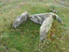
Doe Tor Cist
OS Map: SX 54383 84846
HER: MDV3251
Megalithic Portal: 44223
PMD: Doe Tor
Alternate name: Doe Tor E. Cist
ShortName: CT Doe Tor
Butler map: 32.21
Butler Vol 5: p.198 & Fig.141
DPD page: 10
Grinsell: LYD 12
Barrow Report: 24
Notes: Butler Doe Tor E - Vol. 2. Map 32.21 (diagram Vol. 5. p.198).
Nearby sites: SX 54383 84846
Distance: 1.47km
Down Pool - Black Hill (Mary Tavy) Ancient Pool
OS Map: SX 52285 82404
HER: MDV127205
ShortName: PO:Down Pool
Notes: "Down Pool, Black Hill (Mary Tavy) measures 23 by 24m One of over 40 such 'sacred' pools identified on Dartmoor that are thought to have potentially been designed during the prehistoric period"
Nearby sites: SX 52285 82404
Distance: 1.83km
Ger Tor Platform Cairn Circle
OS Map: SX 54627 83330
HER: MDV11809
Megalithic Portal: 45645
Alternate name: Ger Tor Summit Platform Cairn Circle
ShortName: PC:Ger Tor
Butler map: 32.4
Turner: E24
Notes: "Cairn on ger tor, n side. Platform circle with ring of kerb stones 4.6m internal diam, enclosing flat-topped cairn 0.2m high. Much disturbed (turner)."
UPDATE 31/12/2022. HER link changed from the now deleted MDV48908. NGRs updated accordingly to match MDV11809.
Nearby sites: SX 54627 83330
Distance: 1.59km
Nattor Down 5 Cist
OS Map: SX 5409 8286
HER: MDV3223
Megalithic Portal: 45784
PMD: Nattor Down 5
ShortName: CT:Nattor 5
Butler map: 32.2.5
Butler Vol 5: p.65 & Fig.43
DPD page: 12
Grinsell: PET 14
Notes: "Only the north east sidestone, which is 1.2m long and the north west endstone which is 0.5m long remain in position. The endstone leans slightly inwards. Top of sidestone is 0.4m above ground level. The depth of the kist is unknown. A possible coverstone lies 2.0m due south of the kist. The kistvaen is contained in a turf covered cairn 4.6m in diameter and approx.0.3m high.". Butler Nattor Down 5 - Vol. 2. Map 32.2 (diagram Vol. 5. p.65). 127 Lethbridge pp.11-12, photo and diagram p.12.
Nearby sites: SX 5409 8286
Distance: 1.46km
Ring of Bells Stone Ring Cairn Circle
OS Map: SX 5214 8287
HER: MDV3221
Megalithic Portal: 45837
ShortName: RC:RingofBells
Grinsell: MAR 2
Turner: A34
Notes: "Ring cairn with entrance. Stone ring 13m internal diam, with bank 1.5m wide and 0.3m high.3m wide entrance on ese side. Flag pole has been sited here"
Nearby sites: SX 5214 8287
Distance: 1.54km
White Hill Cist
OS Map: SX 53717 84201
HER: MDV3216
Megalithic Portal: 45783
PMD: White Hill NE.
Alternate name: White Hill 10 Cist
ShortName: CT WhiteHill
Butler map: 32.22.10
Butler Vol 5: p.217 & Fig.151
DPD page: 11
Grinsell: PET 11
Notes: Butler Vol. 2. Map 32, 22.10 (Cairn 10 - diagram of cairn cemetery on White Hill on p.107, diagram Vol. 5. p.217). Lethbridge photo p11.
Nearby sites: SX 53717 84201
Distance: 0.57km
White Hill (N) Stone Ring Cairn Circle
OS Map: SX 53521 83947
HER: MDV14428
Megalithic Portal: 45826
Alternate name: White Hill N.E. (c.24) Stone Ring Cairn Circle
ShortName: RC:WhiteHill N
Butler map: 32.22.12
Grinsell: PET 10
Turner: A11
Notes: Cairn field. Difficult to identify relevant HER record. The HER number (14428) linked gives a listing of the HER records of cairns in this area. The HER record 51457 gives the OS grid reference and description of 13 cairns. Turners A11 has internal diameter 13.2 m, width height 1 x 0.3m, G. Peter Tavy 9.
Nearby sites: SX 53521 83947
Distance: 0.35km
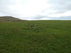
White Hill S. Cairn Alignment Stone Ring Cairn Circle
OS Map: SX 52941 83690
HER: MDV21078
Megalithic Portal: 45821
Alternate name: White Hill 1 Stone Ring Cairn Circle
ShortName: RC WhiteHill S
Butler map: 32.22.1
Grinsell: PET 1
Turner: A8
Notes: "Ring cairn 460 metres south-west of White Hill summit, forming part of the White Hill round cairn cemetery. This monument includes a ring cairn situated on a gentle west-facing slope overlooking Willsworthy Army Camp. The earthwork appears as a raised internal platform measuring 15m in diameter surrounded by a circular bank 3.5m wide and 0.5m high. A shallow hollow in the centre of the internal area suggests robbing or partial early excavation. This cairn forms part of the White Hill round cairn cemetery." NMR A. Cairn is part of an alignment of cairns, see photo.
Butler Cairns 1-6: SX52948369, SX53008367, SX53058366, SX53098365, SX53148365, SX53158366
Nearby sites: SX 52941 83690
Distance: 0.39km