
Prehistoric sites within 3km of SX 66900 80600
Guidance for walkers: The monuments featured in this database are archaeological treasures and need to be protected and preserved - please do not disturb any sites. Please check access and firing times before visiting sites, not all sites listed are on open access land. Firing ranges and boundaries of open access areas are marked on the OL28 OS Dartmoor Explorer map. Please stick to the country code and consider giving support to the numerous agencies that help to keep Dartmoor a fabulous natural and historic environment!
About the database listings: In all listings clicking on the photo or the site name will open a page for the site with a larger photo and further details from the database. The database now has over 6680 records covering nearly all publicly listed sites on Dartmoor including around 4800 round houses. This level of detail is of interest to archaeologists but tends to swamp listings of sites more likely to be of interest for walkers. For this reason, the listings default to around 550 core sites only. These are the stone circles, stone rows and the ring cairns listed by Turner. The default search radius is 2 km. The controls below the map can be used to start a new search by entering a 6- or 8-digit reference (without the prefix "SX"). The search radius can be specified and you can add incremental Display layers of detail on top of the core sites. If using a more detailed layer you will need to decrease the search radius to avoid getting hundreds of search results.
- Core sites Default listing of core sites consisting of stone circles & rows and some of the major ring cairns.
- Plus cairns adds approx. 1000 cairns and other minor sites not included in the core listings but excluding round houses.
- Plus round houses adds approx. 4800 round houses.
- Plus non-sites adds in the records for sites that no longer exist or are not prehistoric sites.
- Plus duplicates adds records excluded as duplicates. Those maybe duplicate records in external listings (e.g. the Historic Environment Records). For example, some sites have been identified as cairns in some listings and interpreted as round houses in other listings and both records appear.
These listings have incorporated, matched up and merged all of the records from all of the major archaeological listings including: Worth, Grinsell, Turner, Butler, Bill Radcliffe, Sandy Gerrard, Megalithic Portal, the National Monument Records and the Historic Environment Records. The author would like to thank Bill, Sandy, the lovely people both at Megalithic Portal (especially Anne Tate who did an amazing job to link listings) and at ACE Archaeology for collaborative work over the years to synchronise and correct listings across the various websites which now interlink. A culmination of years of work the final merger of cairn records took 3 months of cross referencing in 2017 the result being a snapshot of the records at that time. This data has in turn been refined since by field work and research. The round house data was supplied by Sandy Gerrard. Grid references are in order of accuracy: from Google Earth satellite, if visible and found, from a Garmin GPS reading, if visited by the author and from the literature otherwise. Individual site pages will state the source of the grid reference and provide satellite imagery. If a site listing lacks a photo it has not yet been visited by the author in which case the grid reference is from the literature.
Currently the database only includes sites which can be represented by a grid reference. Reaves are not included as they require GIS shape technology which is beyond the current capability of this system. To see the sources for the records, look at the tables on the resources menu. The database listings can also be viewed on a Google map and downloaded as GPS datasets for Garmin devices.
Corrections, or any feedback or suggestions are very welcome, email: info@dartmoorwalks.org.uk.
NOTE: Clicking on the icons for each monument in the map will give the name of the site. You can zoom in and out and drag the map around.
List of sites within 3km of SX 66900 80600
Assycombe Round House
OS Map: SX 65957 82762
HER: MDV14807
ShortName: HT:Assycombe1
Nearby sites: SX 65957 82762
Distance: 2.36km
Assycombe Round House
OS Map: SX 65936 82464
HER: MDV14807
ShortName: HT:Assycombe2
Nearby sites: SX 65936 82464
Distance: 2.10km
Assycombe Round House
OS Map: SX 65909 82687
HER: MDV14807
ShortName: HT:Assycombe3
Nearby sites: SX 65909 82687
Distance: 2.31km
Assycombe Round House
OS Map: SX 66042 82469
HER: MDV6570
ShortName: HT:Assycombe4
Nearby sites: SX 66042 82469
Distance: 2.06km
Assycombe Round House
OS Map: SX 65906 82863
HER: MDV14807
ShortName: HT:Assycombe5
Nearby sites: SX 65906 82863
Distance: 2.47km
Assycombe Round House
OS Map: SX 65905 82852
HER: MDV14807
ShortName: HT:Assycombe6
Nearby sites: SX 65905 82852
Distance: 2.46km
Assycombe Round House
OS Map: SX 66014 82459
HER: MDV6602
ShortName: HT:Assycombe7
Nearby sites: SX 66014 82459
Distance: 2.06km
Assycombe Round House
OS Map: SX 66018 82593
HER: MDV6569
ShortName: HT Assycombe8
Notes: HER: The largest hut circle in the Assycombe Brook settlement of 8.1 metres with walls 1.5 metres wide by 0.9 metres high and the only one not to have been planted over. It is on the south side and at the west end of Assycombe Stone Row. It was excavated in 1894 in an attempt to discover the relationship between it and the stone row. Unfortunately, however, it was found to have been dug into as a source of stone and nothing useful was found.. Breton p.68.
Nearby sites: SX 66018 82593
Distance: 2.18km
Assycombe Hill S Round House
OS Map: SX 66622 81450
HER: MDV6676
ShortName: HT:Assycombe9
Nearby sites: SX 66622 81450
Distance: 0.89km
Assycombe Hill S Round House
OS Map: SX 66605 81381
HER: MDV6676
ShortName: HT:Assycombe10
Nearby sites: SX 66605 81381
Distance: 0.83km
Assycombe Hill S Round House
OS Map: SX 66609 81388
HER: MDV6676
ShortName: HT:Assycombe11
Nearby sites: SX 66609 81388
Distance: 0.84km
Assycombe Hill S Round House
OS Map: SX 66615 81436
HER: MDV6676
ShortName: HT:Assycombe12
Nearby sites: SX 66615 81436
Distance: 0.88km
Assycombe Hill S Round House
OS Map: SX 66614 81408
HER: MDV6676
ShortName: HT:Assycombe13
Nearby sites: SX 66614 81408
Distance: 0.86km
Assycombe Hill S Round House
OS Map: SX 66621 81410
HER: MDV6676
ShortName: HT:Assycombe14
Nearby sites: SX 66621 81410
Distance: 0.86km
Assycombe Hill S Round House
OS Map: SX 66635 81414
HER: MDV6676
ShortName: HT:Assycombe15
Nearby sites: SX 66635 81414
Distance: 0.86km
Assycombe Hill S Round House
OS Map: SX 66636 81518
HER: MDV6676
ShortName: HT:Assycombe16
Nearby sites: SX 66636 81518
Distance: 0.96km
Assycombe Hill S Round House
OS Map: SX 66637 81529
HER: MDV6676
ShortName: HT:Assycombe17
Nearby sites: SX 66637 81529
Distance: 0.97km
Assycombe Hill S Round House
OS Map: SX 66651 81404
HER: MDV6676
ShortName: HT:Assycombe18
Nearby sites: SX 66651 81404
Distance: 0.84km
Assycombe Hill S Round House
OS Map: SX 66699 81461
HER: MDV6676
ShortName: HT:Assycombe19
Nearby sites: SX 66699 81461
Distance: 0.88km
Assycombe Hill S Round House
OS Map: SX 66638 81391
HER: MDV6676
ShortName: HT:Assycombe20
Nearby sites: SX 66638 81391
Distance: 0.83km
Assycombe Hill S Round House
OS Map: SX 66639 81410
HER: MDV6676
ShortName: HT:Assycombe21
Nearby sites: SX 66639 81410
Distance: 0.85km
Assycombe Hill S Round House
OS Map: SX 66695 81457
HER: MDV6676
ShortName: HT:Assycombe22
Nearby sites: SX 66695 81457
Distance: 0.88km
Assycombe Hill S Round House
OS Map: SX 66686 81454
HER: MDV6676
ShortName: HT:Assycombe23
Nearby sites: SX 66686 81454
Distance: 0.88km
Assycombe Hill S Round House
OS Map: SX 66642 81394
HER: MDV6676
ShortName: HT:Assycombe24
Nearby sites: SX 66642 81394
Distance: 0.83km
Assycombe Hill S Round House
OS Map: SX 6662 8141
HER: MDV6676
ShortName: HT:Assycombe25
Nearby sites: SX 6662 8141
Distance: 0.86km
Bush Down Round House
OS Map: SX 68496 82180
HER: MDV6595
ShortName: HT:Bush Down1
Nearby sites: SX 68496 82180
Distance: 2.25km
Bush Down Round House
OS Map: SX 68486 82158
HER: MDV6596
ShortName: HT:Bush Down2
Nearby sites: SX 68486 82158
Distance: 2.22km
Bush Down Round House
OS Map: SX 68695 82535
HER: MDV6598
ShortName: HT:Bush Down3
Nearby sites: SX 68695 82535
Distance: 2.64km
Bush Down Round House
OS Map: SX 68415 82475
HER: MDV6591
ShortName: HT:Bush Down4
Nearby sites: SX 68415 82475
Distance: 2.41km
Bush Down Round House
OS Map: SX 68408 82476
HER: MDV6590
ShortName: HT:Bush Down5
Nearby sites: SX 68408 82476
Distance: 2.41km
Bush Down Round House
OS Map: SX 68402 82477
HER: MDV6590
ShortName: HT:Bush Down6
Nearby sites: SX 68402 82477
Distance: 2.40km
Bush Down Round House
OS Map: SX 68452 82286
HER: MDV6594
ShortName: HT:Bush Down7
Nearby sites: SX 68452 82286
Distance: 2.29km
Bush Down Round House
OS Map: SX 68460 82413
HER: MDV6593
ShortName: HT:Bush Down8
Nearby sites: SX 68460 82413
Distance: 2.39km
Bush Down Round House
OS Map: SX 68624 82036
ShortName: HT:Bush Down9
Nearby sites: SX 68624 82036
Distance: 2.24km
Bush Down Round House
OS Map: SX 68702 82575
HER: MDV6597
ShortName: HT:Bush Down10
Nearby sites: SX 68702 82575
Distance: 2.67km
Bush Down Round House
OS Map: SX 68438 82411
HER: MDV6592
ShortName: HT:Bush Down11
Nearby sites: SX 68438 82411
Distance: 2.38km
Bush Down Round House
OS Map: SX 68601 82026
ShortName: HT:Bush Down12
Nearby sites: SX 68601 82026
Distance: 2.22km
Chagford Common Round House
OS Map: SX 67949 83260
HER: MDV64190
ShortName: HT:Chagford 2
Nearby sites: SX 67949 83260
Distance: 2.86km
Chagford Common Round House
OS Map: SX 67889 83165
HER: MDV64191
ShortName: HT:Chagford 4
Nearby sites: SX 67889 83165
Distance: 2.75km
Chagford Common Round House
OS Map: SX 67937 83287
HER: MDV64189
ShortName: HT:Chagford 6
Nearby sites: SX 67937 83287
Distance: 2.88km
Chagford Common Round House
OS Map: SX 67796 82967
HER: MDV64194
ShortName: HT:Chagford 13
Nearby sites: SX 67796 82967
Distance: 2.53km
Chagford Common Round House
OS Map: SX 67850 83345
HER: MDV43227
ShortName: HT:Chagford 14
Nearby sites: SX 67850 83345
Distance: 2.90km
Chagford Common Round House
OS Map: SX 67849 83291
HER: MDV6706
ShortName: HT:Chagford 15
Nearby sites: SX 67849 83291
Distance: 2.85km
Chagford Common Round House
OS Map: SX 67854 83063
HER: MDV64193
ShortName: HT:Chagford 16
Nearby sites: SX 67854 83063
Distance: 2.64km
Chagford Common Round House
OS Map: SX 67857 83145
HER: MDV64192
ShortName: HT Chagford 17
Nearby sites: SX 67857 83145
Distance: 2.72km
Challacombe Round House
OS Map: SX 69664 79903
HER: MDV5990
ShortName: HT:Challacom4
Nearby sites: SX 69664 79903
Distance: 2.85km
Challacombe Round House
OS Map: SX 69649 79889
HER: MDV5990
ShortName: HT:Challacom5
Nearby sites: SX 69649 79889
Distance: 2.84km
Challacombe Round House
OS Map: SX 69613 80096
HER: MDV54571
ShortName: HT:Challacom6
Nearby sites: SX 69613 80096
Distance: 2.76km
Challacombe Down Round House
OS Map: SX 6862 8040
HER: MDV6700
ShortName: HT:Challacom12
Nearby sites: SX 6862 8040
Distance: 1.73km
Challacombe Down Round House
OS Map: SX 68593 80233
HER: MDV6700
ShortName: HT:Challacom13
Nearby sites: SX 68593 80233
Distance: 1.73km
Challacombe Down Round House
OS Map: SX 68588 80273
HER: MDV6700
ShortName: HT:Challacom14
Nearby sites: SX 68588 80273
Distance: 1.72km
Challacombe Down Round House
OS Map: SX 68614 80233
HER: MDV6700
ShortName: HT:Challacom15
Nearby sites: SX 68614 80233
Distance: 1.75km
Challacombe Down Round House
OS Map: SX 6846 8056
HER: MDV6659
ShortName: HT:Challacom16
Nearby sites: SX 6846 8056
Distance: 1.56km
Challacombe Down Round House
OS Map: SX 68525 80524
HER: MDV6664
ShortName: HT:Challacom17
Nearby sites: SX 68525 80524
Distance: 1.63km
Challacombe Down Round House
OS Map: SX 68485 80533
HER: MDV6662
ShortName: HT:Challacom18
Nearby sites: SX 68485 80533
Distance: 1.59km
Challacombe Down Round House
OS Map: SX 68492 80512
HER: MDV54550
ShortName: HT:Challacom19
Nearby sites: SX 68492 80512
Distance: 1.59km
Challacombe Down Round House
OS Map: SX 68515 80479
HER: MDV6665
ShortName: HT:Challacom20
Nearby sites: SX 68515 80479
Distance: 1.62km
Challacombe Down Round House
OS Map: SX 6850 8058
HER: MDV6663
ShortName: HT:Challacom21
Nearby sites: SX 6850 8058
Distance: 1.60km
Challacombe Down Round House
OS Map: SX 68475 80517
HER: MDV6661
ShortName: HT:Challacom22
Nearby sites: SX 68475 80517
Distance: 1.58km
Chittaford Down Round House
OS Map: SX 643 798
HER: MDV5943
ShortName: HT:Chittafor1
Notes: This entry was originally assigned SX 63000 79000 but the HER record has SX 643 798 - this has now been corrected.
Nearby sites: SX 643 798
Distance: 2.72km
Corndon Down Round House
OS Map: SX 68455 80649
HER: MDV6660
ShortName: HT:Corndon D6
Nearby sites: SX 68455 80649
Distance: 1.56km
East Bovey Head Round House
OS Map: SX 69411 82202
HER: MDV6551
ShortName: HT:East Bove1
Nearby sites: SX 69411 82202
Distance: 2.98km
East Bovey Head Round House
OS Map: SX 69391 82215
HER: MDV6551
ShortName: HT:East Bove2
Nearby sites: SX 69391 82215
Distance: 2.97km
East Bovey Head Round House
OS Map: SX 69396 82210
HER: MDV6551
ShortName: HT:East Bove4
Nearby sites: SX 69396 82210
Distance: 2.97km
East Bovey Head Round House
OS Map: SX 69400 82206
HER: MDV6551
ShortName: HT:East Bove5
Nearby sites: SX 69400 82206
Distance: 2.97km
East Bovey Head Round House
OS Map: SX 69439 82044
HER: MDV64121
ShortName: HT:East Bove6
Nearby sites: SX 69439 82044
Distance: 2.92km
East Bovey Head Round House
OS Map: SX 69405 82204
HER: MDV6551
ShortName: HT:East Bove9
Nearby sites: SX 69405 82204
Distance: 2.97km
East Bovey Head Round House
OS Map: SX 69422 82133
HER: MDV64121
ShortName: HT:East Bove10
Nearby sites: SX 69422 82133
Distance: 2.95km
East Bovey Head Round House
OS Map: SX 69437 82060
HER: MDV64121
ShortName: HT:East Bove12
Nearby sites: SX 69437 82060
Distance: 2.93km
East Bovey Head Round House
OS Map: SX 69430 82034
HER: MDV64121
ShortName: HT:East Bove14
Nearby sites: SX 69430 82034
Distance: 2.91km
Grimspound W Round House
OS Map: SX 6985 8084
HER: MDV54579
ShortName: HT:Grimspoun33
Nearby sites: SX 6985 8084
Distance: 2.96km
Hartland Tor E Round House
OS Map: SX 64340 80078
HER: MDV6801
ShortName: HT:Hartland 1
Nearby sites: SX 64340 80078
Distance: 2.61km
Hartland Tor E Round House
OS Map: SX 64349 80087
HER: MDV6801
ShortName: HT:Hartland 2
Nearby sites: SX 64349 80087
Distance: 2.60km
Hartland Tor E Round House
OS Map: SX 64292 80162
HER: MDV6801
ShortName: HT:Hartland 3
Nearby sites: SX 64292 80162
Distance: 2.64km
Hartland Tor E Round House
OS Map: SX 64363 80041
HER: MDV54681
ShortName: HT:Hartland 4
Nearby sites: SX 64363 80041
Distance: 2.60km
Hartland Tor SE Round House
OS Map: SX 64384 79842
HER: MDV12754
ShortName: HT:Hartland 5
Nearby sites: SX 64384 79842
Distance: 2.63km
Hookney Tor NW Round House
OS Map: SX 69762 81404
HER: MDV103609
ShortName: HT:Hookney T1
Nearby sites: SX 69762 81404
Distance: 2.97km
Hookney Tor NW Round House
OS Map: SX 69758 81401
HER: MDV103609
ShortName: HT:Hookney T2
Nearby sites: SX 69758 81401
Distance: 2.97km
Hurston Ridge Round House
OS Map: SX 67419 82579
HER: MDV6668
ShortName: HT:Hurston R1
Nearby sites: SX 67419 82579
Distance: 2.05km
Hurston Ridge Round House
OS Map: SX 67350 82705
HER: MDV61935
ShortName: HT:Hurston R2
Nearby sites: SX 67350 82705
Distance: 2.15km
Hurston Ridge Round House
OS Map: SX 67266 82549
HER: MDV61937
ShortName: HT:Hurston R3
Nearby sites: SX 67266 82549
Distance: 1.98km
Hurston Ridge Round House
OS Map: SX 67270 82546
HER: MDV61938
ShortName: HT:Hurston R4
Nearby sites: SX 67270 82546
Distance: 1.98km
Hurston Ridge Round House
OS Map: SX 67271 82570
ShortName: HT:Hurston R5
Nearby sites: SX 67271 82570
Distance: 2.00km
Hurston Ridge Round House
OS Map: SX 67344 82500
HER: MDV6671
ShortName: HT Hurston R6
Nearby sites: SX 67344 82500
Distance: 1.95km
Hurston Ridge Round House
OS Map: SX 67266 82562
HER: MDV61936
ShortName: HT:Hurston R7
Nearby sites: SX 67266 82562
Distance: 2.00km
King's Oven Round House
OS Map: SX 67449 81288
Alternate name: King's Oven Round House
ShortName: HT:King's Ov1
Nearby sites: SX 67449 81288
Distance: 0.88km
King's Oven Round House
OS Map: SX 67452 81312
Alternate name: King's Oven Round House
ShortName: HT:King's Ov2
Nearby sites: SX 67452 81312
Distance: 0.90km
King's Oven Round House
OS Map: SX 67441 81271
Alternate name: King's Oven Round House
ShortName: HT:King's Ov3
Nearby sites: SX 67441 81271
Distance: 0.86km
Lakehead Hill NE Round House
OS Map: SX 64968 78332
HER: MDV5967
ShortName: HT:Lakehead 1
Nearby sites: SX 64968 78332
Distance: 2.98km
Lakeland Round House
OS Map: SX 6850 8271
HER: MDV6672
ShortName: HT:Lakeland1
Nearby sites: SX 6850 8271
Distance: 2.65km
Lowton Brook Round House
OS Map: SX 66402 82956
HER: MDV6584
ShortName: HT:Lowton Br1
Nearby sites: SX 66402 82956
Distance: 2.41km
Lowton Brook Round House
OS Map: SX 66355 83293
HER: MDV6575
ShortName: HT:Lowton Br2
Nearby sites: SX 66355 83293
Distance: 2.75km
Lowton Brook Round House
OS Map: SX 6634 8307
HER: MDV6718
ShortName: HT:Lowton Br3
Nearby sites: SX 6634 8307
Distance: 2.53km
Lowton Brook Round House
OS Map: SX 66319 83190
HER: MDV6580
ShortName: HT:Lowton Br4
Nearby sites: SX 66319 83190
Distance: 2.65km
Lowton Brook Round House
OS Map: SX 66309 83171
HER: MDV6582
ShortName: HT:Lowton Br5
Nearby sites: SX 66309 83171
Distance: 2.64km
Lowton Brook Round House
OS Map: SX 66301 83156
HER: MDV6581
ShortName: HT:Lowton Br6
Nearby sites: SX 66301 83156
Distance: 2.63km
Lowton Brook Round House
OS Map: SX 66273 83116
HER: MDV6579
ShortName: HT:Lowton Br7
Nearby sites: SX 66273 83116
Distance: 2.59km
Lowton Brook Round House
OS Map: SX 6627 8309
HER: MDV6583
ShortName: HT:Lowton Br8
Nearby sites: SX 6627 8309
Distance: 2.57km
Lowton Brook Round House
OS Map: SX 66246 83239
HER: MDV6583
ShortName: HT:Lowton Br9
Nearby sites: SX 66246 83239
Distance: 2.72km
Lowton Brook Round House
OS Map: SX 66238 83436
HER: MDV6599
ShortName: HT:Lowton Br10
Nearby sites: SX 66238 83436
Distance: 2.91km
Lowton Brook Round House
OS Map: SX 66231 83268
HER: MDV6578
ShortName: HT:Lowton Br11
Nearby sites: SX 66231 83268
Distance: 2.75km
Lowton Brook Round House
OS Map: SX 6623 8332
HER: MDV6574
ShortName: HT:Lowton Br12
Nearby sites: SX 6623 8332
Distance: 2.80km
Lowton Brook Round House
OS Map: SX 66346 82886
HER: MDV6644
ShortName: HT:Lowton Br14
Nearby sites: SX 66346 82886
Distance: 2.35km
Merripit Hill Round House
OS Map: SX 6588 8014
HER: MDV6678
ShortName: HT:Merripit 1
Nearby sites: SX 6588 8014
Distance: 1.12km
Merripit Hill Round House
OS Map: SX 66246 80225
HER: MDV6678
ShortName: HT:Merripit 2
Nearby sites: SX 66246 80225
Distance: 0.75km
Riddon Brake Round House
OS Map: SX 6669 7774
HER: MDV5984
ShortName: HT:Riddon Br1
Nearby sites: SX 6669 7774
Distance: 2.87km
Stannon Round House
OS Map: SX 6534 8048
HER: MDV19553
ShortName: HT:Stannon1
Nearby sites: SX 6534 8048
Distance: 1.56km
Stannon Hill Round House
OS Map: SX 6542 8014
HER: MDV27760
ShortName: HT:Stannon H1
Nearby sites: SX 6542 8014
Distance: 1.55km
Stannon Tor S Round House
OS Map: SX 6457 8056
HER: MDV27275
ShortName: HT:Stannon T1
Nearby sites: SX 6457 8056
Distance: 2.33km
Water Hill Round House
OS Map: SX 67238 81415
ShortName: HT:Water Hil1
Nearby sites: SX 67238 81415
Distance: 0.88km
Water Hill Round House
OS Map: SX 67241 81425
ShortName: HT:Water Hil2
Nearby sites: SX 67241 81425
Distance: 0.89km
Water Hill Round House
OS Map: SX 67250 81438
ShortName: HT:Water Hil3
Nearby sites: SX 67250 81438
Distance: 0.91km
Water Hill Round House
OS Map: SX 67273 81344
ShortName: HT:Water Hil4
Nearby sites: SX 67273 81344
Distance: 0.83km
Water Hill N Round House
OS Map: SX 67157 81723
HER: MDV54624
ShortName: HT:Water Hil5
Nearby sites: SX 67157 81723
Distance: 1.15km
Water Hill N Round House
OS Map: SX 67162 81732
HER: MDV54624
ShortName: HT:Water Hil6
Nearby sites: SX 67162 81732
Distance: 1.16km
Water Hill SW Round House
OS Map: SX 66395 81025
HER: MDV54600
ShortName: HT:Water Hil7
Nearby sites: SX 66395 81025
Distance: 0.66km
Water Hill SW Round House
OS Map: SX 66385 80995
HER: MDV54600
ShortName: HT:Water Hil8
Nearby sites: SX 66385 80995
Distance: 0.65km
White Ridge S Round House
OS Map: SX 64696 81605
HER: MDV59433
ShortName: HT:White Rid5
Nearby sites: SX 64696 81605
Distance: 2.42km
White Ridge S Round House
OS Map: SX 64788 81709
HER: MDV59428
ShortName: HT:White Rid6
Nearby sites: SX 64788 81709
Distance: 2.39km
White Ridge S Round House
OS Map: SX 64805 81762
HER: MDV59432
ShortName: HT:White Rid7
Nearby sites: SX 64805 81762
Distance: 2.40km
White Ridge S Round House
OS Map: SX 64828 81732
HER: MDV59430
ShortName: HT:White Rid8
Nearby sites: SX 64828 81732
Distance: 2.36km
White Ridge S Round House
OS Map: SX 64638 81559
HER: MDV59434
ShortName: HT:White Rid9
Nearby sites: SX 64638 81559
Distance: 2.46km
White Ridge W Round House
OS Map: SX 64275 81818
HER: MDV6748
ShortName: HT:White Rid10
Nearby sites: SX 64275 81818
Distance: 2.89km
White Ridge W Round House
OS Map: SX 64396 81562
HER: MDV59425
ShortName: HT:White Rid11
Nearby sites: SX 64396 81562
Distance: 2.68km
White Ridge W Round House
OS Map: SX 64296 81879
HER: MDV6748
ShortName: HT:White Rid12
Nearby sites: SX 64296 81879
Distance: 2.90km
White Ridge W Round House
OS Map: SX 64388 81561
HER: MDV59426
ShortName: HT:White Rid13
Nearby sites: SX 64388 81561
Distance: 2.69km

White Ridge W Round House
OS Map: SX 64248 81808
HER: MDV6748
ShortName: HT White Rid14
Nearby sites: SX 64248 81808
Distance: 2.91km
White Ridge W Round House
OS Map: SX 64357 81800
HER: MDV6748
ShortName: HT:White Rid15
Nearby sites: SX 64357 81800
Distance: 2.81km
White Ridge W Round House
OS Map: SX 64353 81607
HER: MDV59427
ShortName: HT:White Rid16
Nearby sites: SX 64353 81607
Distance: 2.74km
White Ridge W Round House
OS Map: SX 64239 81665
HER: MDV6775
ShortName: HT:White Rid17
Nearby sites: SX 64239 81665
Distance: 2.87km

White Ridge W Round House
OS Map: SX 64266 81830
HER: MDV6748
ShortName: HT White Rid19
Nearby sites: SX 64266 81830
Distance: 2.91km
White Ridge W Round House
OS Map: SX 64287 81897
HER: MDV6748
ShortName: HT:White Rid20
Nearby sites: SX 64287 81897
Distance: 2.92km
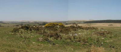
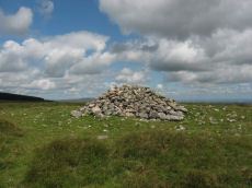
Grendon Farm (Hill W of) Cairn Circle
OS Map: SX 6805 7835
HER: MDV6008
ShortName: CN:GrendonFarm
Grinsell: WID 1a
Notes: HER: Cairn located on highest point of hill west of Grendon Farm, measuring 12 metres in diameter, composed of small stones overgrown with gorse and heather. Disturbed on the eastern side.
Nearby sites: SX 6805 7835
Distance: 2.53km
Red Barrows 2 Cairn
Prehistoric Dartmoor Walks: Dartmoor Site: Soussons Cairn Circle
OS Map: SX 67709 79666
HER: MDV6006
ShortName: CN RedBar 2
Butler map: 24.2.2
Grinsell: MAN 6
Barrow Report: 56
Notes: HER: One of a row of four barrows on Soussons Down known as 'The Red Barrows' of 13.7 metres in diameter by 1.2 metres high. Excavated by the Dartmoor Exploration Committee in 1902. Fragments of burnt bone and wood charcoal found in central pit, with further bone, wood charcoal in paved area. Two indeterminate fragments of bronze also found, and a flint arrowhead.
Nearby sites: SX 67709 79666
Distance: 1.24km
Red Barrows 3 Cairn
Prehistoric Dartmoor Walks: Dartmoor Site: Soussons Cairn Circle
OS Map: SX 67694 79690
HER: MDV6005
ShortName: CN RedBar 3
Butler map: 24.2.3
Grinsell: MAN 7
Notes: HER: One of a row of four barrows on Soussons Down known as 'The Red Barrows'. It is a substantial mound of 21.0 metres diameter by 1.3 metres high and appears to be undamaged. Two edge set stones on the south eastern side of the mound may represent the remains of a kerb which survives elsewhere as a buried feature
Nearby sites: SX 67694 79690
Distance: 1.21km
Red Barrows 4 Cairn
Prehistoric Dartmoor Walks: Dartmoor Site: Soussons Cairn Circle
OS Map: SX 67695 79705
HER: MDV6004
ShortName: CN RedBar 4
Butler map: 24.2.4
Grinsell: MAN 8
Notes: HER: Northern of a row of four barrows on Soussons Down known as 'The Red Barrows' survives as flat topped 10 metres diameter mound standing up to 0.5 metres high
Nearby sites: SX 67695 79705
Distance: 1.20km

Soussons Plantation N.1 Cairn
Prehistoric Dartmoor Walks: Dartmoor Site: Soussons Cairn Circle
OS Map: SX 67673 79963
HER: MDV6015
The Stone Rows of GB: Soussons Down
ShortName: CN Soussons N1
Butler map: 24.2.5
Butler Vol 5: p.38 & Fig.15
Grinsell: MAN 4
Notes: Cairn at north end of the Red Barrows stone row.
Nearby sites: SX 67673 79963
Distance: 1.00km
Hurston Ridge Stone Row Cairn
OS Map: SX 67266 82438
HER: MDV61939
PMD: Hurston Ridge Stone Row
ShortName: CN HurstonRow
Butler map: 25.9
Butler Vol 5: p.221 & Fig.154
Grinsell: CHA 5
Notes: The cairn at the upper end of the alignment measures 5.9 metres in diameter and stands up to a height of 0.6 metres. A large slab denoting the north eastern edge of the cairn may represent a second blocking stone of the associated alignment. A cinerary urn was found in the cairn. "The cairn has been throughly rifled ... It's shape is irregular ... but with no sign of the cist at one time visible here" (Butler Vol 2 p.30).
Nearby sites: SX 67266 82438
Distance: 1.87km

White Ridge S.W. Cairn
OS Map: SX 6414 8160
HER: MDV6770
ShortName: CN WhiteRid SW
Butler map: 35.11
Grinsell: LYD 19
Notes: Round cairn lying immediately west of an enclosed stone hut circle settlement in Great Stannon newtake (SX64158160). Diameter 7.2 metres, height 0. 9 metres. Kerb. Robbed. Central pit 2.2 metres by 0.8 metres by 0.1 metres deep. Grass covered mound with some edge set stones on the west side which may represent the remnants of a kerb. The orientation of the central pit is 123 degrees. Large number of stones protruding from the mound, many of which have quartz in them.
Nearby sites: SX 6414 8160
Distance: 2.94km
White Ridge Stone Row Cairn
OS Map: SX 6541 8165
HER: MDV6639
ShortName: CN WhiteRid 1
Butler map: 35.20
Grinsell: LYD 27
Notes: HER: Remains of a badly damaged cairn of up to 10 metres across by 0.3 metres high at the north end of the stone row to the south-east of White Ridge. It is composed of stone and soil but no kerb slabs are visible
Nearby sites: SX 6541 8165
Distance: 1.82km

Stannon Newtake W. Cairn
OS Map: SX 6533 8108
HER: MDV6657
ShortName: CN Stannon 2
Butler map: 35.21.2
Grinsell: LYD 28
Barrow Report: 15
Notes: Cairn a short distance to the north of the northernmost coaxial field boundary. The cairn survives as a 6.5m diameter mound up to 0.6m high. A central hollow is the result of excavation in 1896 which revealed a pit containing charcoal, burnt bone and a flint flake. A group of four edge set stones up to 1m high to the southeast are the remains of a stone alignment.
Nearby sites: SX 6533 8108
Distance: 1.64km
Stannon Bottom Cairn
OS Map: SX 6539 8060
HER: MDV6677
ShortName: CN?Stannon 5
Grinsell: LYD 30a
Notes: Three cairns noted on the edge of a hut circle settlement on Merripit Hill. Unclear whether these are ritual or clearance cairns as they may have been hut circles that have been covered with loose stone.
Nearby sites: SX 6539 8060
Distance: 1.51km

Hurston Ridge Cairn
OS Map: SX 67003 81844
HER: MDV6609
ShortName: CN Hurston
Butler map: 25.10
Grinsell: LYD 30
Notes: Hurston ridge; pillaged cairn (diam 8m) examined in 1900. Yielded large portion of broken urn (circumference 1.12m), resting mouth down on flat stone covering pit filled with wood charcoal. The urn was partly protected by a leaning stone kept in position by trigger stones. Highly ornamented. Dark, friable pottery containing little clay. No surrounding stone circle (worth).
Nearby sites: SX 67003 81844
Distance: 1.25km
Assycombe Hill S.1 Cairn
OS Map: SX 6625 8116
HER: MDV61310
ShortName: CN:AssycombS1
Butler map: 26.4.1
Butler Vol 5: p.199
Notes: NMR 916309 clearly refers to Butler's Assycombe Hill S.1 & S.2. The entry refers to Butler's coverage Vol 2 p. 26. It is clear from Butler that the NGR is SX 662 812. This is clear both from the listingat the end of Vol2 as well as from where they are marked on Butler's Map 26. The text states "The proximity of these two cairns on te summit of the ridge 400 m to the suth-west suggests these may have been the burial mounds of the community" i.e the Assycombe Hill South settlement. However, the NGR given in the NMR is SX 662802 which is 1 km to the south! This error has resulted in duplicate entries for the HER which has this pair of cairns at both locations. HER 54601 & 54602 are duplicates (with incorrect NGRs) of 61309 & 61310.
Nearby sites: SX 6625 8116
Distance: 0.86km
Assycombe Hill S.2 Cairn
OS Map: SX 6624 8118
HER: MDV61309
ShortName: CN:AssycombS2
Butler map: 26.4.2
Butler Vol 5: p.218 & Fig.152
Notes: NMR 916309 clearly refers to Butler's Assycombe Hill S.1 & S.2. The entry refers to Butler's coverage Vol 2 p. 26. It is clear from Butler that the NGR is SX 662 812. This is clear both from the listingat the end of Vol2 as well as from where they are marked on Butler's Map 26. The text states "The proximity of these two cairns on te summit of the ridge 400 m to the suth-west suggests these may have been the burial mounds of the community" i.e the Assycombe Hill South settlement. However, the NGR given in the NMR is SX 662802 which is 1 km to the south! This error has resulted in duplicate entries for the HER which has this pair of cairns at both locations. HER 54601 & 54602 are duplicates (with incorrect NGRs) of 61309 & 61310.
Nearby sites: SX 6624 8118
Distance: 0.88km
Stannon Newtake b Cairn
OS Map: SX 65193 81487
HER: MDV15378
PMD: Stannon Newtake b
ShortName: CN:Stannon 4
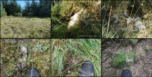
Notes: (greeves + robinson) prehistoric long cairn 16m long, 6.50m width (max), 1m high (highest at ne end). Small rectangular depression in ne end and stone slab set on edge at sw end. Composed mostly of small stone, covered with gorse and is disturbed by track at sw end. The author attempted to find this feature on 18/07/2025 and the area is covered with very dense and high gorse making it extremely difficult to access or see any potential features. Is the grid reference wrong? Looking at Lidar data the HER grid reference of SX 6518 8149 is close. It can clearly be seen on lidar at SX 65193 81487 which is 13 metres from the HER grid reference. The gird reference has been updated on this record to the Lidar feature. A screengrab of the lidar data imagery is included here with the feature highlighted.
Nearby sites: SX 65193 81487
Distance: 1.92km

White Ridge 2 Cairn
OS Map: SX 65027 82187
HER: MDV20915
ShortName: CN WhiteRid 2
Notes: HER: The monument includes a round cairn lying on the summit of White Ridge situated within Great Stannon Newtake. The cairn lies in a very prominent position and commands extensive views over much of Dartmoor. The mound measures 15.8 metres in diameter and stands up to 0.7 metres high. A number of edge set stones on the southern edge of the mound may represent a kerb, which survives elsewhere as a buried feature. Three pits in the mound suggest robbing or partial early excavation.
Nearby sites: SX 65027 82187
Distance: 2.45km
Lakehead Hill 14 Cairn
OS Map: SX 6496 7847
HER: MDV52768
ShortName: CN:Lakehead 14
Notes: HER: Two low stoney cairns situated in open moorland on the gently sloping north-eastern flank of Lakehead Hill 500m south of Postbridge.
Nearby sites: SX 6496 7847
Distance: 2.88km
Lakehead Hill 15 Cairn
OS Map: SX 6494 7850
HER: MDV52769
ShortName: CN:Lakehead 15
Notes: HER: Denuded mound, probably barrow located on open moorland on Lakehead Hill. The flat-topped mound measures 8.5m ns by 5.0m with a maximum height of 0.35m. There is no stone apparent in the construction of this feature and though partially obscured by long grass it appears to be undisturbed.
Nearby sites: SX 6494 7850
Distance: 2.87km
Hurston Common Cairn
OS Map: SX 6766 8350
HER: MDV61934
ShortName: CN:Hurston
Notes: HER: Cairn or hut circle on the north side of a D-shaped enclosure on west side of Hurston Main Reave on Chagford Common. NB. Formerly listed here as "Hurston Ridge" which duplicates the name of another cairn to the SW. Renamed to Hurston Common (07/09/2025).
Nearby sites: SX 6766 8350
Distance: 3.00km

Headland Warren 1 Cairn
OS Map: SX 69442 81584
HER: MDV103580
ShortName: CN Headland 1
Nearby sites: SX 69442 81584
Distance: 2.73km

Headland Warren 2 Cairn
OS Map: SX 69361 81746
HER: MDV103581
ShortName: CN Headland 2
Nearby sites: SX 69361 81746
Distance: 2.71km
Merripit Hill 1 Cairn
OS Map: SX 66359 79926
HER: MDV103610
ShortName: CN:Merripit 1
Nearby sites: SX 66359 79926
Distance: 0.86km

Merripit Hill 2 Clearance Cairn
OS Map: SX 6575 8044
HER: MDV19555
ShortName: CN?Merripit 2
Grinsell: B:LYD 30b
Notes: On the summit of Merripit Hill is a prominent mound representing an infilled mine shaft enclosed by debris. Grinsell List B of "Doubtful and rejected sites". Entry LYDFORD 30B has the description "industrial spoil heap".
Nearby sites: SX 6575 8044
Distance: 1.16km
Kings Oven Reported Cist
OS Map: SX 67477 81336
HER: MDV121913
PMD: King's Oven
ShortName: CT?KingsOven 1
Butler map: 26.1.2
Notes: In the wall of King's Oven enclosure. Butler gives NGR for CHA 6a by mistake.
Nearby sites: SX 67477 81336
Distance: 0.94km
Kings Oven (Near) Reported Cist
OS Map: SX 6747 8129
HER: MDV6620
ShortName: CT?KingsOven 2
Butler map: 26.5
Grinsell: CHA 6a
Notes: Destroyed? Fragmenary remains of cairn and cist reported by Speence Bate in 1871
Nearby sites: SX 6747 8129
Distance: 0.89km
Stannon Newtake a Reported Cist
OS Map: SX 6492 8123
HER: MDV19547
PMD: Stannon Newtake a
ShortName: CN:Stannon 3
Notes: Four upright slabs form a crude semi-circle on a small shelf of an otherwise steep, e-facing and clitter strewn hillside, above stannon brook. The semi-circle described by the slabs is 3m in diam with a max height of 0.7m. It does not form a recognisable archaeological feature and seems more like random assemblage of natural slabs
Nearby sites: SX 6492 8123
Distance: 2.08km

Water Hill 2 Reported Cairn
OS Map: SX 67155 81314
HER: MDV6675
ShortName: CN?WaterHill 2
Butler map: 26.5.2
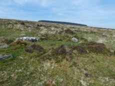
Notes: Doubtful "a heather covered mound slightly to the n of the large cairn on the summit of water hill. It measures 5.1m in diam and up to 0.6m high with one recumbent granite boulder visible on its s side. It is apparently composed of earth and stone". This record formerly linked to MDV54619 which has presumably been deleted as a duplicate.
Visited by author on a few occasions and not recorded due to doubt about identification. The raised area in the photo is the only possible candidate for Butler's satellite cairn.
Nearby sites: SX 67155 81314
Distance: 0.76km
Lakehead Hill 10 Reported Cairn
OS Map: SX 6504 7826
HER: MDV5921
ShortName: CN?Lakehead 10
Butler map: 27.19.10
Grinsell: LYD 51a
Barrow Report: 55
Notes: HER: Unconfirmed; there is no ground evidence to suggest the presence of the cairn noted by Worth. The feature described by Grinsell is probably the robbed hut circle. 1976 reports states it was destroyed through road building.
Nearby sites: SX 6504 7826
Distance: 2.99km
Chagford Common 6 Reported Cairn
OS Map: SX 675 830
HER: MDV13039
ShortName: CN:Chagford 6
Grinsell: CHA 10a-i
Notes: 1902 exc. Unlocated - maybe CHA 7-9
Nearby sites: SX 675 830
Distance: 2.47km
West Vitifer (duplicate) Reported Cairn
OS Map: SX 675 826
ShortName: CT?WestVitif 2
Notes: Possible location of a Bronze Age cist, although when subject to field investigation in November 2002 the site was not found. This record originates with the now discontinued NMR records and is most likely a duplicate of NMR 443785 i.e HER MDV6615, see West Vitifer Cist (SiteID=423)
Nearby sites: SX 675 826
Distance: 2.09km
Soussons Plantation N.2 Reported Cairn
OS Map: SX 6791 7982
HER: MDV6086
ShortName: CNxSoussons N2
Nearby sites: SX 6791 7982
Distance: 1.28km
Hartland Tor N Reported Cairn
OS Map: SX 6413 8083
HER: MDV20488
ShortName: CN?Hartland N
Nearby sites: SX 6413 8083
Distance: 2.78km
Lowton Brook Reported Cairn
OS Map: SX 6690 8287
HER: MDV54605
ShortName: CN:Lowton Bk
Nearby sites: SX 6690 8287
Distance: 2.27km
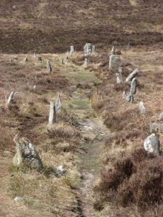
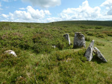
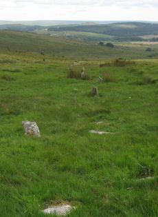
Assycombe Stone Row
Prehistoric Dartmoor Walks: Dartmoor Site: Assycombe Double Stone Row
OS Map: SX 66095 82641
HER: MDV6537
Megalithic Portal: 1738
The Stone Rows of GB: Assycombe Stone Row
PMD: Assycombe Stone Row
ShortName: SR Assycombe
Butler map: 35.19
DPD page: 135
Notes: "Bronze Age stone row and cairn, Assycombe. The double stone row is 120m long terminating in the cairn at the North-East end. The South-West end is blocked by a stone 2.0m high, re-erected there by Baring-Gould. The cairn is 8.4m in diameter and 0.6m high. Scheduled." Also from Burnard's 1892 field notes: The row, which starts from a ruined cairn, consists of 84 standing stones, and extends 800 feet E. and W., running in two rows down the hill towards Assycombe. It terminates towards the W. in a stone lying prone, 5' 9" long. 2'' wide. The avenue is from 5' to 6' wide, inner measurement. The stones composing the row are 18" high, and down to 6". Breton p.67-68.
Nearby sites: SX 66095 82641
Distance: 2.19km
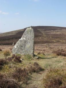
Assycombe Standing Stone
Prehistoric Dartmoor Walks: Dartmoor Site: Assycombe Double Stone Row
OS Map: SX 66101 82649
HER: MDV6537
Megalithic Portal: 1738
PMD: Assycombe Standing Stone
ShortName: SS Assycombe
Butler map: 35.19
DPD page: 135
Notes: Bronze Age stone row and cairn, Assycombe. The double stone row is 120m long terminating in the cairn at the North-East end. The South-West end is blocked by a stone 2.0m high. The largest stone, 2m high, lies at the E end and was re-erected re-erected by Baring-Gould in 1892 or 1893. The cairn is 8.4m in diameter and 0.6m high. Breton p.68.
Nearby sites: SX 66101 82649
Distance: 2.20km
Assycombe Hill Encircled Cairn and Cist
Prehistoric Dartmoor Walks: Dartmoor Site: Assycombe Double Stone Row
OS Map: SX 66102 82650
HER: MDV6538
Megalithic Portal: 45814
PMD: Assycombe Stone Row
Alternate name: Assycombe Hill Stone Row Encircled Cairn and Cist
ShortName: CT Assycombe
Butler map: 35.19
Butler Vol 5: p.232 & Fig.164
DPD page: 135
Grinsell: LYD 26
Turner: F16
Notes: The cairn at the E end is in line with the N of the two rows. It measures 8.4m in diameter and is 0.6m high. It contains a large quantity of stone; two stones in the centre, set at right angles to each other around a hollow, suggest the remains of a cist. Breton p.68.
Nearby sites: SX 66102 82650
Distance: 2.20km
Birch Tor Cairn
OS Map: SX 68686 81654
HER: MDV6673
Megalithic Portal: 34981
Alternate name: Birch Tor Summit Cairn
ShortName: CN:Birch Tor
Butler map: 24.4
Grinsell: N.BOV 1
Barrow Report: 56
Notes: "The heavily disturbed remains of a large, flat-topped cairn lie on the ridge crest 230 metres north of Birch Tor. The centre and south margin of this feature have apparently suffered from an unrecorded excavation with spoil dumped to the south and on the east fringe of the mound. Two large upright slabs are embedded in the unexcavated interior of the cairn and may have previously been interpreted as elements of a kerb even though they lie several metres in from the actual edge of the feature. 10m to the north-west of the cairn is a warren boundary stone inscribed with the letters`WB'on its eastern side."
Nearby sites: SX 68686 81654
Distance: 2.07km
Birch Tor Ancient Pool
OS Map: SX 68686 81656
HER: MDV127183
ShortName: PO:Birch Tor
Notes: "The pool at Birch Tor measures around 15.5m. One of over 40 such 'sacred' pools identified on Dartmoor that are thought to have potentially been designed during the prehistoric period."
Nearby sites: SX 68686 81656
Distance: 2.07km
Bush Down Settlement
OS Map: SX 6849 8217
HER: MDV6596
Megalithic Portal: 7699
ShortName: ST:BushDown
Nearby sites: SX 6849 8217
Distance: 2.23km
Cator Pound
Prehistoric Dartmoor Walks: Dartmoor Site: Cator Pound
OS Map: SX 6730 7765
HER: MDV6009
Megalithic Portal: 34961
ShortName: PD Cator Pound
Notes: HER: Cator pound, widecombe. In his survey of widecombe made about 1750, dean milles describes 'a very considerable circle of stones on the n part of the western down on a farm called cator and on an eminence called whitehill'; he gives the diameter as 58 paces and says it consisted 'chiefly of large stones mowst of which rise about 4 feet above ye ground. This circle consists now of about 30 stones but there are spaces where several more stood, half the number are fallen; the rest are either erect or on their sides'.
Nearby sites: SX 6730 7765
Distance: 2.98km
Cator Common Embanked Cairn Circle
Prehistoric Dartmoor Walks: Dartmoor Site: Cator Pound
OS Map: SX 67426 78001
HER: MDV5978
Megalithic Portal: 52173
ShortName: CC CatorCommon
Butler map: 18.4
Grinsell: WID 1
Turner: B3
Notes: HER: Cairn, hollow towards centre. Retaining circle of c.28 upright slabs, mostly turned inwards. Diameter 18.0m, height 0.6m. Breton p.41
Nearby sites: SX 67426 78001
Distance: 2.65km
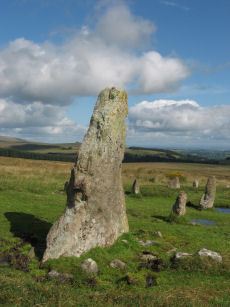
Challacombe Down Standing Stone
Prehistoric Dartmoor Walks: Dartmoor Site: Challacombe Down Triple Stone Row
OS Map: SX 69021 80723
HER: MDV6600
Megalithic Portal: 10092
PMD: Challacombe Stone Row
ShortName: SS Challacombe
Butler map: 24.3
DPD page: 126
Notes: The largest and most prominent blocking stone of the Dartmoor rows is to be found at the Challacombe triple row. Worth states that it is over 5 feet in width at the base and over 6 feet in height. Butler (Vol. 2) states that the terminal pillar is today 0.5m shorter than when it was measured in 1893.
Nearby sites: SX 69021 80723
Distance: 2.12km
Challacombe Down Stone Row
Prehistoric Dartmoor Walks: Dartmoor Site: Challacombe Down Triple Stone Row
OS Map: SX 69016 80718
HER: MDV6600
Megalithic Portal: 1819
The Stone Rows of GB: Challacombe Down
PMD: Challacombe Stone Row
ShortName: SR Challacombe
Butler map: 24.3
Butler Vol 5: p.239 & Fig.169
DPD page: 126
Notes: "Bronze Age triple stone row well marked and wider apart at the north, drawing nearer to the south where they meet a blocking stone of unusual size. The stones have suffered little in their restoration except that a stone in the middle row was turned to form a blocking stone for that row. The loose stones scattered to the west of the north end have been suggested to form a stone circle and additional rows but may be stones excavated from the north end of the stone row." Breton p.41-42
Nearby sites: SX 69016 80718
Distance: 2.12km

Challacombe Down Cairn Circle
Prehistoric Dartmoor Walks: Dartmoor Site: Challacombe Down Triple Stone Row
OS Map: SX 6898 8084
HER: MDV49462
Megalithic Portal: 1819
PMD: Challacombe Down Stone Row
ShortName: CC Challacombe
Butler map: 24.3
Butler Vol 5: p.239 & Fig.169
Turner: G20
Notes: Dubious site - the current arrangement relates to stones placed during restoration of the stone row. See Worth (1953) p. 226 on how "nothing coherent" came of attempts to re-erect stones scattered to the west of the north end of the row which gave the appearance of a stone circle.
Nearby sites: SX 6898 8084
Distance: 2.09km

Hurston Ridge Settlement
OS Map: SX 674 825
HER: MDV6668
Megalithic Portal: 34979
ShortName: ST Hurston
Butler map: 25.9
Nearby sites: SX 674 825
Distance: 1.96km
Hurston Ridge Standing Stone
Prehistoric Dartmoor Walks: Dartmoor Site: Hurston Ridge Double Stone Row
OS Map: SX 67268 82444
HER: MDV6541
Megalithic Portal: 8345
PMD: Hurston Ridge Standing Stone
ShortName: SS Hurston
Butler map: 25.9
DPD page: 136
Notes: Hurston Ridge is one of the best examples of a double stone now on Dartmoor. At the south end is a cairn 22 feet in diameter. The space between the rows widens intentionally as it approaches the cairn. The first stone from the south in the eastern row is the largest stone and stands 5 feet 10 inches high. Crossing suggests this may have been the original Heath Stone.
Nearby sites: SX 67268 82444
Distance: 1.88km

Hurston Ridge Stone Row
Prehistoric Dartmoor Walks: Dartmoor Site: Hurston Ridge Double Stone Row
OS Map: SX 67260 82437
HER: MDV6541
Megalithic Portal: 8345
The Stone Rows of GB: Hurston Ridge
PMD: Hurston Ridge Stone Row
ShortName: SR Hurston
Butler map: 25.9
Butler Vol 5: p.228 & Fig.161
DPD page: 136
Notes: .Worth: Watern Hill. "A stone alignment which includes two parallel lines of upright stones leading downslope for 143 metres from a round cairn. The lower end of the alignment is denoted by a blocking stone. Midway along the alignment a length of later enclosure walling crosses the row. The cairn at the upper end of the alignment measures 5.9 metres in diameter and stands up to a height of 0.6 metres. A large slab denoting the north eastern edge of the cairn may represent a second blocking stone of the associated alignment." A number of the stones were restored to their original sockets in 1894. A broken hand axe was discovered in the pit in which one of the stones had stood near to the menhir next to the cairn. First observed by Mr. George French of Postbridge.
Nearby sites: SX 67260 82437
Distance: 1.87km
King's Oven (Water Hill) Cairn
OS Map: SX 67158 81299
HER: MDV6674
Megalithic Portal: 34690
PMD: Water Hill Possible Chambered Cairn
Alternate name: Water Hill 1 Cairn
ShortName: CN WaterHill 1
Butler map: 26.5.1
Butler Vol 5: p.156 & Fig.95
Grinsell: CHA 6
Notes: Situated at SX 67158129 on the rounded summit of Water Hill is the remains of a substantial round cairn 18.0 metres in diameter and up to 1.4 metres high in the east and 0.9 metres in the west. The whole of the central area of the cairn has been robbed to construct a superimposed modern boundary cairn 4.0 metres in diam and 2.1 metres high. This has given a 'dished' appearance to the cairn proper. Several large slabs averaging 0.8 metres by 0.7 metres scattered around the base of the boundary cairn may be the remains of a destroyed cist.
Nearby sites: SX 67158 81299
Distance: 0.75km
Lowton Brook W. Settlement
OS Map: SX 663 834
HER: MDV104672
Megalithic Portal: 24262
ShortName: ST:LowtonBkW
Nearby sites: SX 663 834
Distance: 2.86km
Red Barrows Cairn
Prehistoric Dartmoor Walks: Dartmoor Site: Soussons Cairn Circle
OS Map: SX 67718 79650
HER: MDV6007
Megalithic Portal: 34986
PMD: Red Barrows
Alternate name: Red Barrows 1 Cairn
ShortName: CN RedBar 1
Butler map: 24.2.1
Grinsell: MAN 5
Notes: Four Bronze Age round barrows between 10 and 20 meters in diameter and 0.5 to 2.2 meters high. One barrow was excavated in 1902, finds included pottery and flints. See also HER records, 6004, 6005, 6006, 6007.
Nearby sites: SX 67718 79650
Distance: 1.25km
Ringhill Stones Reported Stone Row
OS Map: SX 6473 7947
HER: MDV5856
Megalithic Portal: 2101
ShortName: SRxRinghill
Notes: Breton p.34: Ringhill Stones stand in a field E. of the farm. The two large ones are 15ft. apart. The largest is nearly 5ft. high They were formerly part of stone rows which have been destroyed. 203 yds N.E. of the stones close to the Stannon Brook is the site of a blowing house; just beyond is a stone hedge, built into it is a mould stone.. HER: standing stones. Only two of the five standing stones could be found, it appears that the remainder were destroyed during the construction of an occupational road to Hartyland. These stones are of very weathered appearance, suggestive of great antiquity. See also entry on Megalithic Portal.
Nearby sites: SX 6473 7947
Distance: 2.45km
Shapley Common Round House
OS Map: SX 6942 8206
HER: MDV6553
Megalithic Portal: 45859
ShortName: HC:ShapleyComm
DPD page: 128
Notes: Lethbridge p.128 Hut Circle on Shapley Common - particularly fine example.
Nearby sites: SX 6942 8206
Distance: 2.91km
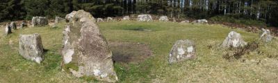
Soussons Common Ring Setting Cairn and Cist
Prehistoric Dartmoor Walks: Dartmoor Site: Soussons Cairn Circle
OS Map: SX 67516 78700
HER: MDV6013
Megalithic Portal: 1266
PMD: Soussons Plantation
Alternate name: Soussons Plantation S. Ring Setting Cairn and Cist
ShortName: CT Soussons Cm
Butler map: 24.2.6
DPD page: 124
Grinsell: MAN 9
Turner: D2
Barrow Report: 22 23 45 56
Notes: "A 28 feet diameter cairn circle with a central cist (plan). The tallest stone in the cairn circle is about 2 feet high." "This cist measures at least 1.3 metres long by 0.5 metres wide and when excavated in 1903 two coils of human hair were found". Lethbridge p.124. Butler Soussons Plantation S - Vol. 2. Map 24.2.6 (diagrams pp. 18-20). Breton p.41.
Nearby sites: SX 67516 78700
Distance: 2.00km
Soussons Down (Red Barrows) Stone Row
Prehistoric Dartmoor Walks: Dartmoor Site: Soussons Cairn Circle
OS Map: SX 6767 7998
HER: MDV6015
Megalithic Portal: 2136
The Stone Rows of GB: Soussons Down
PMD: Red Barrows Stone Row
Alternate name: Soussons Down Stone Row
ShortName: SR Red Barrows
Butler map: 24.2
Notes: Triple row destroyed in 1946 Butler Vol. 5 p38, Vol. 2 Map 24.2 p.19. The row was associated with a cairn about 300m north of the four Red Barrow cairn group (SX 67 NE 3). Butler mentions that some of the stones of the row remained and these were observed and reported to Sandy Gerrard by Chris Jenkins.
Nearby sites: SX 6767 7998
Distance: 0.99km
Stannon Little Newtake Ring Setting Cairn and Cist
OS Map: SX 65464 81068
HER: MDV6616
Megalithic Portal: 37598
PMD: Stannon Newtake
Alternate name: Stannon Newtake E. Ring Setting Cairn and Cist
ShortName: CT Stannon 1
Butler map: 35.21.1
DPD page: 124
Grinsell: LYD 29
Turner: D16
Barrow Report: 57
Notes: "Cairn survives as a 4.5 metre diameter mound up to 0.5 metres high. The western edge is denoted by a kerb of edge set slabs up to 1.15 metres high. The eastern edge is beneath a later boundary bank. A cist in the centre is a rectangular pit 1.2 metres by 0.5 metres denoted by edge set slabs". Butler Stannon Newtake E. - Vol. 2. Map 35.21 (diagram p.168). Visited again by the author 18/07/2025 and quite overgrown - the outer kerb can be seen but the cist is covered by vegetation. Breton p.45.
Nearby sites: SX 65464 81068
Distance: 1.51km

Stannon Newtake Stone Row
OS Map: SX 65348 81091
HER: MDV54555
Megalithic Portal: 2144
The Stone Rows of GB: Stannon Newtake
PMD: Stannon Newtake Stone Row
ShortName: SR Stannon New
Butler map: 35.21
Notes: HER: A group of four edge set stones standing up to 1 metre high, situated to the southeast of the cairn, represent the remains of a stone alignment. Possible extension of the White Ridge Stone Row. "Standing stones, possibly a stone row. Forty-six feet S. of the cairn (SX 68 SE 23) are two standing stones, two and a half feet high, their broad planes facing the monument. These, and two others in line, suggest the remains of a stone row, destroyed for materials for an ancient hedge. If a row, it does not point to the centre of the cairn."
Nearby sites: SX 65348 81091
Distance: 1.63km

West Vitifer Cist
OS Map: SX 67575 82802
HER: MDV6615
Megalithic Portal: 34980
PMD: Chagford Common
ShortName: CT WestVitif 1
Butler map: 25.11
Grinsell: CHA 4
Barrow Report: 16
Notes: "Possible location of a Bronze Age cist, although when subject to field investigation in November 2002 the site was not found" "The cairn was partially excavated in 1897 by the Barrow Committee of the Devonshire Association. This working revealed a ring of slabs surrounding a cist which had not been previously examined. In the cist there was a complete Bronze Age beaker together with charcoal but no trace of a burial."
Nearby sites: SX 67575 82802
Distance: 2.30km
White Ridge Stone Row
OS Map: SX 65420 81661
HER: MDV6642
Megalithic Portal: 4145
The Stone Rows of GB: White Ridge
PMD: White Ridge Stone Row
ShortName: SR White Ridge
Butler map: 35.20
DPD page: 125
Notes: "A double stone row, 620 ft in length from the centre of a cairn at the north end, running nearly due south and slightly downhill. Well preserved at the north end for a short distance but becoming more dilapidated as it approaches the newtake wall at the south end". Lethbridge diagram p.124 and photo top p.125. Breton p.45 sadly robbed to build the wall, but the upper part is still a good specimen of the double avenue. It is 260 yds. long; there are three stones on the S. side of the wall.
Nearby sites: SX 65420 81661
Distance: 1.82km