
Prehistoric sites within 2km of SX 67127 63012
Guidance for walkers: The monuments featured in this database are archaeological treasures and need to be protected and preserved - please do not disturb any sites. Please check access and firing times before visiting sites, not all sites listed are on open access land. Firing ranges and boundaries of open access areas are marked on the OL28 OS Dartmoor Explorer map. Please stick to the country code and consider giving support to the numerous agencies that help to keep Dartmoor a fabulous natural and historic environment!
About the database listings: In all listings clicking on the photo or the site name will open a page for the site with a larger photo and further details from the database. The database now has over 6680 records covering nearly all publicly listed sites on Dartmoor including around 4800 round houses. This level of detail is of interest to archaeologists but tends to swamp listings of sites more likely to be of interest for walkers. For this reason, the listings default to around 550 core sites only. These are the stone circles, stone rows and the ring cairns listed by Turner. The default search radius is 2 km. The controls below the map can be used to start a new search by entering a 6- or 8-digit reference (without the prefix "SX"). The search radius can be specified and you can add incremental Display layers of detail on top of the core sites. If using a more detailed layer you will need to decrease the search radius to avoid getting hundreds of search results.
- Core sites Default listing of core sites consisting of stone circles & rows and some of the major ring cairns.
- Plus cairns adds approx. 1000 cairns and other minor sites not included in the core listings but excluding round houses.
- Plus round houses adds approx. 4800 round houses.
- Plus non-sites adds in the records for sites that no longer exist or are not prehistoric sites.
- Plus duplicates adds records excluded as duplicates. Those maybe duplicate records in external listings (e.g. the Historic Environment Records). For example, some sites have been identified as cairns in some listings and interpreted as round houses in other listings and both records appear.
These listings have incorporated, matched up and merged all of the records from all of the major archaeological listings including: Worth, Grinsell, Turner, Butler, Bill Radcliffe, Sandy Gerrard, Megalithic Portal, the National Monument Records and the Historic Environment Records. The author would like to thank Bill, Sandy, the lovely people both at Megalithic Portal (especially Anne Tate who did an amazing job to link listings) and at ACE Archaeology for collaborative work over the years to synchronise and correct listings across the various websites which now interlink. A culmination of years of work the final merger of cairn records took 3 months of cross referencing in 2017 the result being a snapshot of the records at that time. This data has in turn been refined since by field work and research. The round house data was supplied by Sandy Gerrard. Grid references are in order of accuracy: from Google Earth satellite, if visible and found, from a Garmin GPS reading, if visited by the author and from the literature otherwise. Individual site pages will state the source of the grid reference and provide satellite imagery. If a site listing lacks a photo it has not yet been visited by the author in which case the grid reference is from the literature.
Currently the database only includes sites which can be represented by a grid reference. Reaves are not included as they require GIS shape technology which is beyond the current capability of this system. To see the sources for the records, look at the tables on the resources menu. The database listings can also be viewed on a Google map and downloaded as GPS datasets for Garmin devices.
Corrections, or any feedback or suggestions are very welcome, email: info@dartmoorwalks.org.uk.
NOTE: Clicking on the icons for each monument in the map will give the name of the site. You can zoom in and out and drag the map around.
List of sites within 2km of SX 67127 63012
Corringdon Ball Round House
OS Map: SX 67023 61015
HER: MDV5817
ShortName: HT:Corringdo38
Nearby sites: SX 67023 61015
Distance: 2.00km
Corringdon Ball Round House
OS Map: SX 6701 6107
HER: MDV25693
ShortName: HT:Corringdo40
Nearby sites: SX 6701 6107
Distance: 1.95km
Red Brook Round House
OS Map: SX 67116 62895
HER: MDV5792
ShortName: HT:Red Brook1
Nearby sites: SX 67116 62895
Distance: 0.12km
Red Brook Round House
OS Map: SX 67177 62871
HER: MDV5792
ShortName: HT:Red Brook2
Nearby sites: SX 67177 62871
Distance: 0.15km
Red Brook Round House
OS Map: SX 67161 62845
HER: MDV5792
ShortName: HT:Red Brook3
Nearby sites: SX 67161 62845
Distance: 0.17km
Red Brook Round House
OS Map: SX 67149 62842
HER: MDV5792
ShortName: HT:Red Brook4
Nearby sites: SX 67149 62842
Distance: 0.17km
Red Brook Round House
OS Map: SX 67143 62884
HER: MDV5792
ShortName: HT:Red Brook5
Nearby sites: SX 67143 62884
Distance: 0.13km
Red Brook Round House
OS Map: SX 67138 62842
HER: MDV5792
ShortName: HT:Red Brook6
Nearby sites: SX 67138 62842
Distance: 0.17km
Old Hill Round House
OS Map: SX 66885 62999
HER: MDV5785
ShortName: HT:Old Hill1
Nearby sites: SX 66885 62999
Distance: 0.24km
Red Brook Round House
OS Map: SX 67128 62868
HER: MDV5792
ShortName: HT:Red Brook7
Nearby sites: SX 67128 62868
Distance: 0.14km
Red Brook Round House
OS Map: SX 67012 62805
HER: MDV13266
ShortName: HT:Red Brook8
Nearby sites: SX 67012 62805
Distance: 0.24km
Red Brook Round House
OS Map: SX 67120 62861
HER: MDV5792
ShortName: HT:Red Brook9
Nearby sites: SX 67120 62861
Distance: 0.15km
Red Brook Round House
OS Map: SX 67181 62848
HER: MDV5794
ShortName: HT:Red Brook10
Nearby sites: SX 67181 62848
Distance: 0.17km
Red Brook Round House
OS Map: SX 67107 62872
HER: MDV5792
ShortName: HT:Red Brook11
Nearby sites: SX 67107 62872
Distance: 0.14km
Red Brook Round House
OS Map: SX 67068 62834
HER: MDV13265
ShortName: HT:Red Brook12
Nearby sites: SX 67068 62834
Distance: 0.19km
Brent Fore Hill nr Summit Cairn
OS Map: SX 66246 62190
HER: MDV42317
ShortName: CN:BrentFore 1
Nearby sites: SX 66246 62190
Distance: 1.20km
Red Brook Round House
OS Map: SX 67074 62839
HER: MDV13265
ShortName: HT:Red Brook13
Nearby sites: SX 67074 62839
Distance: 0.18km
Red Brook Round House
OS Map: SX 67123 62869
HER: MDV5792
ShortName: HT:Red Brook14
Nearby sites: SX 67123 62869
Distance: 0.14km
Rider's Rings Round House
OS Map: SX 67814 64347
HER: MDV5767
ShortName: HT:Rider's R1
Nearby sites: SX 67814 64347
Distance: 1.50km
Rider's Rings Round House
OS Map: SX 67789 64324
HER: MDV5767
ShortName: HT:Rider's R2
Nearby sites: SX 67789 64324
Distance: 1.47km
Rider's Rings Round House
OS Map: SX 67780 64297
HER: MDV5767
ShortName: HT:Rider's R3
Nearby sites: SX 67780 64297
Distance: 1.44km
Rider's Rings Round House
OS Map: SX 67780 64316
HER: MDV5767
ShortName: HT:Rider's R4
Nearby sites: SX 67780 64316
Distance: 1.46km
Rider's Rings Round House
OS Map: SX 67899 64392
HER: MDV5767
ShortName: HT:Rider's R5
Nearby sites: SX 67899 64392
Distance: 1.58km
Zeal Hill E Round House
OS Map: SX 67762 64027
HER: MDV79013
ShortName: HT:Zeal Hill1
Nearby sites: SX 67762 64027
Distance: 1.20km
Rider's Rings Round House
OS Map: SX 67814 64265
HER: MDV5767
ShortName: HT:Rider's R6
Nearby sites: SX 67814 64265
Distance: 1.43km
Zeal Hill E Round House
OS Map: SX 67725 64046
HER: MDV79014
ShortName: HT:Zeal Hill2
Nearby sites: SX 67725 64046
Distance: 1.19km
Rider's Rings Round House
OS Map: SX 67763 64265
HER: MDV5767
ShortName: HT:Rider's R7
Nearby sites: SX 67763 64265
Distance: 1.41km
Zeal Hill E Round House
OS Map: SX 67783 64052
HER: MDV26430
ShortName: HT:Zeal Hill3
Nearby sites: SX 67783 64052
Distance: 1.23km
Rider's Rings Round House
OS Map: SX 67760 64305
HER: MDV5767
ShortName: HT:Rider's R8
Nearby sites: SX 67760 64305
Distance: 1.44km
Zeal Hill E Round House
OS Map: SX 67776 64101
HER: MDV79015
ShortName: HT:Zeal Hill4
Nearby sites: SX 67776 64101
Distance: 1.27km
Rider's Rings Round House
OS Map: SX 67758 64298
HER: MDV5767
ShortName: HT:Rider's R9
Nearby sites: SX 67758 64298
Distance: 1.43km
Zeal Hill E Round House
OS Map: SX 67756 64018
HER: MDV79012
ShortName: HT:Zeal Hill5
Nearby sites: SX 67756 64018
Distance: 1.19km
Rider's Rings Round House
OS Map: SX 67755 64278
HER: MDV5767
ShortName: HT:Rider's R10
Nearby sites: SX 67755 64278
Distance: 1.41km
Zeal Hill S Round House
OS Map: SX 67028 63075
HER: MDV5754
ShortName: HT:Zeal Hill6
Nearby sites: SX 67028 63075
Distance: 0.12km
East Glaze Brook Round House
OS Map: SX 66622 61440
HER: MDV13267
ShortName: HT:East Glaz1
Nearby sites: SX 66622 61440
Distance: 1.65km
Rider's Rings Round House
OS Map: SX 67809 64342
HER: MDV5767
ShortName: HT:Rider's R11
Nearby sites: SX 67809 64342
Distance: 1.49km
Zeal Hill S Round House
OS Map: SX 67029 63177
ShortName: HT:Zeal Hill7
Nearby sites: SX 67029 63177
Distance: 0.19km
East Glaze Brook Round House
OS Map: SX 66704 61424
HER: MDV13267
ShortName: HT:East Glaz2
Nearby sites: SX 66704 61424
Distance: 1.64km
Rider's Rings Round House
OS Map: SX 67795 64246
HER: MDV5767
ShortName: HT:Rider's R12
Nearby sites: SX 67795 64246
Distance: 1.40km
Zeal Hill S Round House
OS Map: SX 67019 63081
HER: MDV5754
ShortName: HT:Zeal Hill8
Nearby sites: SX 67019 63081
Distance: 0.13km
East Glaze Brook Round House
OS Map: SX 66352 61523
HER: MDV5669
ShortName: HT:East Glaz3
Nearby sites: SX 66352 61523
Distance: 1.68km
Rider's Rings Round House
OS Map: SX 67796 64315
HER: MDV5767
ShortName: HT:Rider's R13
Nearby sites: SX 67796 64315
Distance: 1.46km
Zeal Hill S Round House
OS Map: SX 67117 63011
ShortName: HT:Zeal Hill9
Nearby sites: SX 67117 63011
Distance: 0.01km
East Glaze Brook Round House
OS Map: SX 66708 61381
HER: MDV13267
ShortName: HT:East Glaz4
Nearby sites: SX 66708 61381
Distance: 1.68km
Rider's Rings Round House
OS Map: SX 67882 64395
HER: MDV5767
ShortName: HT:Rider's R14
Nearby sites: SX 67882 64395
Distance: 1.58km
Zeal Hill S Round House
OS Map: SX 67035 63073
HER: MDV5754
ShortName: HT:Zeal Hill10
Nearby sites: SX 67035 63073
Distance: 0.11km
East Glaze Brook Round House
OS Map: SX 6658 6146
HER: MDV13267
ShortName: HT:East Glaz5
Nearby sites: SX 6658 6146
Distance: 1.65km
Rider's Rings Round House
OS Map: SX 67894 64387
HER: MDV5767
ShortName: HT:Rider's R15
Nearby sites: SX 67894 64387
Distance: 1.57km
Zeal Hill S Round House
OS Map: SX 67086 63052
ShortName: HT:Zeal Hill11
Nearby sites: SX 67086 63052
Distance: 0.06km
Black Tor Round House
OS Map: SX 68004 63345
HER: MDV14155
ShortName: HT:Black Tor1
Nearby sites: SX 68004 63345
Distance: 0.94km
East Glaze Brook Round House
OS Map: SX 66714 61393
HER: MDV13267
ShortName: HT:East Glaz6
Nearby sites: SX 66714 61393
Distance: 1.67km
Rider's Rings Round House
OS Map: SX 68013 64472
HER: MDV5767
ShortName: HT:Rider's R16
Nearby sites: SX 68013 64472
Distance: 1.71km
Zeal Hill S Round House
OS Map: SX 67002 63211
HER: MDV25667
ShortName: HT:Zeal Hill12
Nearby sites: SX 67002 63211
Distance: 0.24km
Black Tor Round House
OS Map: SX 68001 63320
HER: MDV14155
ShortName: HT:Black Tor2
Nearby sites: SX 68001 63320
Distance: 0.93km
East Glaze Brook Round House
OS Map: SX 66389 61594
ShortName: HT:East Glaz7
Nearby sites: SX 66389 61594
Distance: 1.60km
Rider's Rings Round House
OS Map: SX 67999 64467
HER: MDV5767
ShortName: HT:Rider's R17
Nearby sites: SX 67999 64467
Distance: 1.70km
Zeal Hill S Round House
OS Map: SX 66997 63214
HER: MDV25667
ShortName: HT:Zeal Hill13
Nearby sites: SX 66997 63214
Distance: 0.24km
Black Tor Round House
OS Map: SX 68013 63373
HER: MDV14155
ShortName: HT:Black Tor3
Nearby sites: SX 68013 63373
Distance: 0.96km
East Glaze Brook Round House
OS Map: SX 66695 61377
HER: MDV13267
ShortName: HT:East Glaz8
Nearby sites: SX 66695 61377
Distance: 1.69km
Rider's Rings Round House
OS Map: SX 67995 64484
HER: MDV5767
ShortName: HT:Rider's R18
Nearby sites: SX 67995 64484
Distance: 1.71km
Zeal Hill S Round House
OS Map: SX 66992 63218
HER: MDV25667
ShortName: HT:Zeal Hill14
Nearby sites: SX 66992 63218
Distance: 0.25km
Black Tor Round House
OS Map: SX 67898 63382
HER: MDV5800
ShortName: HT:Black Tor4
Nearby sites: SX 67898 63382
Distance: 0.86km
East Glaze Brook Round House
OS Map: SX 66703 61373
HER: MDV13267
ShortName: HT:East Glaz9
Nearby sites: SX 66703 61373
Distance: 1.69km
Rider's Rings Round House
OS Map: SX 67984 64473
HER: MDV5767
ShortName: HT:Rider's R19
Nearby sites: SX 67984 64473
Distance: 1.69km
Zeal Hill S Round House
OS Map: SX 67045 63065
HER: MDV5754
ShortName: HT:Zeal Hill15
Nearby sites: SX 67045 63065
Distance: 0.10km
Black Tor Round House
OS Map: SX 67914 63378
HER: MDV5800
ShortName: HT:Black Tor5
Nearby sites: SX 67914 63378
Distance: 0.87km
East Glaze Brook Round House
OS Map: SX 66594 61453
HER: MDV13267
ShortName: HT:East Glaz10
Nearby sites: SX 66594 61453
Distance: 1.65km
Rider's Rings Round House
OS Map: SX 67960 64459
HER: MDV5767
ShortName: HT:Rider's R20
Nearby sites: SX 67960 64459
Distance: 1.67km
Zeal Hill S Round House
OS Map: SX 67057 63076
HER: MDV5754
ShortName: HT:Zeal Hill16
Nearby sites: SX 67057 63076
Distance: 0.09km
Black Tor Round House
OS Map: SX 67979 63302
HER: MDV5795
ShortName: HT:Black Tor6
Nearby sites: SX 67979 63302
Distance: 0.90km
East Glaze Brook Round House
OS Map: SX 66629 61464
HER: MDV13267
ShortName: HT:East Glaz11
Nearby sites: SX 66629 61464
Distance: 1.63km
Rider's Rings Round House
OS Map: SX 67953 64467
HER: MDV5767
ShortName: HT:Rider's R21
Nearby sites: SX 67953 64467
Distance: 1.67km
Zeal Hill S Round House
OS Map: SX 67066 63039
ShortName: HT:Zeal Hill17
Nearby sites: SX 67066 63039
Distance: 0.07km
Black Tor Round House
OS Map: SX 67981 63330
HER: MDV5795
ShortName: HT:Black Tor7
Nearby sites: SX 67981 63330
Distance: 0.91km
East Glaze Brook Round House
OS Map: SX 66686 61445
HER: MDV13267
ShortName: HT:East Glaz12
Nearby sites: SX 66686 61445
Distance: 1.63km
Rider's Rings Round House
OS Map: SX 67822 64339
HER: MDV5767
ShortName: HT:Rider's R22
Nearby sites: SX 67822 64339
Distance: 1.50km
Zeal Hill S Round House
OS Map: SX 67050 63149
ShortName: HT:Zeal Hill18
Nearby sites: SX 67050 63149
Distance: 0.16km
Black Tor Round House
OS Map: SX 67959 63329
HER: MDV5795
ShortName: HT:Black Tor8
Nearby sites: SX 67959 63329
Distance: 0.89km
East Glaze Brook Round House
OS Map: SX 66748 61360
HER: MDV13267
ShortName: HT:East Glaz13
Nearby sites: SX 66748 61360
Distance: 1.69km
Rider's Rings Round House
OS Map: SX 67918 64419
HER: MDV5767
ShortName: HT:Rider's R23
Nearby sites: SX 67918 64419
Distance: 1.61km
Zeal Hill S Round House
OS Map: SX 67019 63130
ShortName: HT:Zeal Hill19
Nearby sites: SX 67019 63130
Distance: 0.16km
Black Tor Round House
OS Map: SX 67962 63300
HER: MDV5795
ShortName: HT:Black Tor9
Nearby sites: SX 67962 63300
Distance: 0.88km
East Glaze Brook Round House
OS Map: SX 66637 61440
HER: MDV13267
ShortName: HT:East Glaz14
Nearby sites: SX 66637 61440
Distance: 1.65km
Rider's Rings Round House
OS Map: SX 67825 64353
HER: MDV5767
ShortName: HT:Rider's R24
Nearby sites: SX 67825 64353
Distance: 1.51km
Zeal Hill S Round House
OS Map: SX 67094 63004
ShortName: HT:Zeal Hill20
Nearby sites: SX 67094 63004
Distance: 0.03km
Black Tor Round House
OS Map: SX 67894 63143
HER: MDV13259
ShortName: HT:Black Tor10
Nearby sites: SX 67894 63143
Distance: 0.78km
East Glaze Brook Round House
OS Map: SX 66659 61460
HER: MDV13267
ShortName: HT:East Glaz15
Nearby sites: SX 66659 61460
Distance: 1.62km
Rider's Rings Round House
OS Map: SX 67835 64353
HER: MDV5767
ShortName: HT:Rider's R25
Nearby sites: SX 67835 64353
Distance: 1.52km
Zeal Hill S Round House
OS Map: SX 67112 63010
ShortName: HT:Zeal Hill21
Nearby sites: SX 67112 63010
Distance: 0.02km
Black Tor Round House
OS Map: SX 67996 63342
HER: MDV5795
ShortName: HT:Black Tor11
Nearby sites: SX 67996 63342
Distance: 0.93km
East Glaze Brook Round House
OS Map: SX 66734 61369
HER: MDV13267
ShortName: HT:East Glaz16
Nearby sites: SX 66734 61369
Distance: 1.69km
Rider's Rings Round House
OS Map: SX 67842 64306
HER: MDV5767
ShortName: HT:Rider's R26
Nearby sites: SX 67842 64306
Distance: 1.48km
Zeal Hill S Round House
OS Map: SX 67190 62975
ShortName: HT:Zeal Hill22
Nearby sites: SX 67190 62975
Distance: 0.07km
Black Tor Round House
OS Map: SX 67966 63281
HER: MDV5795
ShortName: HT:Black Tor12
Nearby sites: SX 67966 63281
Distance: 0.88km
East Glaze Brook Round House
OS Map: SX 66614 61463
HER: MDV13267
ShortName: HT:East Glaz17
Nearby sites: SX 66614 61463
Distance: 1.63km
Rider's Rings Round House
OS Map: SX 67804 64293
HER: MDV5767
ShortName: HT:Rider's R27
Nearby sites: SX 67804 64293
Distance: 1.45km
Zeal Hill S Round House
OS Map: SX 67119 63005
ShortName: HT:Zeal Hill23
Nearby sites: SX 67119 63005
Distance: 0.01km
Black Tor Round House
OS Map: SX 67825 63271
HER: MDV5801
ShortName: HT:Black Tor13
Nearby sites: SX 67825 63271
Distance: 0.74km
Zeal Hill S Round House
OS Map: SX 67126 63006
ShortName: HT:Zeal Hill24
Nearby sites: SX 67126 63006
Distance: 0.01km
Black Tor Round House
OS Map: SX 67971 63315
HER: MDV5795
ShortName: HT:Black Tor14
Nearby sites: SX 67971 63315
Distance: 0.90km
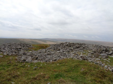
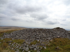
Zeal Hill S Round House
OS Map: SX 67127 63012
ShortName: HT:Zeal Hill25
Nearby sites: SX 67127 63012
Distance: 0.00km
Black Tor Round House
OS Map: SX 67890 63153
HER: MDV28477
ShortName: HT:Black Tor15
Nearby sites: SX 67890 63153
Distance: 0.78km
Zeal Hill S Round House
OS Map: SX 67129 62997
ShortName: HT:Zeal Hill26
Nearby sites: SX 67129 62997
Distance: 0.02km
Black Tor Round House
OS Map: SX 67988 63337
HER: MDV5795
ShortName: HT:Black Tor16
Nearby sites: SX 67988 63337
Distance: 0.92km
Hickley Ridge Round House
OS Map: SX 6732 6250
HER: MDV25704
ShortName: HT:Hickley R1
Nearby sites: SX 6732 6250
Distance: 0.55km
Zeal Hill S Round House
OS Map: SX 67142 63003
ShortName: HT:Zeal Hill27
Nearby sites: SX 67142 63003
Distance: 0.02km
Black Tor Round House
OS Map: SX 67994 63354
HER: MDV5795
ShortName: HT:Black Tor17
Nearby sites: SX 67994 63354
Distance: 0.93km
Zeal Hill S Round House
OS Map: SX 67153 63003
ShortName: HT:Zeal Hill28
Nearby sites: SX 67153 63003
Distance: 0.03km
Black Tor Round House
OS Map: SX 67994 63364
HER: MDV5795
ShortName: HT:Black Tor18
Nearby sites: SX 67994 63364
Distance: 0.94km
Zeal Hill S Round House
OS Map: SX 67162 63004
ShortName: HT:Zeal Hill29
Nearby sites: SX 67162 63004
Distance: 0.04km
Black Tor Round House
OS Map: SX 67976 63348
HER: MDV5795
ShortName: HT:Black Tor19
Nearby sites: SX 67976 63348
Distance: 0.91km
Zeal Hill S Round House
OS Map: SX 67178 63004
ShortName: HT:Zeal Hill30
Nearby sites: SX 67178 63004
Distance: 0.05km
Black Tor Round House
OS Map: SX 67996 63311
HER: MDV5795
ShortName: HT:Black Tor20
Nearby sites: SX 67996 63311
Distance: 0.92km
Treeland Downs Round House
OS Map: SX 67272 61232
HER: MDV5787
ShortName: HT:Treeland 1
Nearby sites: SX 67272 61232
Distance: 1.79km
Zeal Hill S Round House
OS Map: SX 67054 63070
HER: MDV5754
ShortName: HT:Zeal Hill31
Nearby sites: SX 67054 63070
Distance: 0.09km
Black Tor Round House
OS Map: SX 67899 63379
HER: MDV5800
ShortName: HT:Black Tor21
Nearby sites: SX 67899 63379
Distance: 0.85km
Treeland Downs Round House
OS Map: SX 67417 61416
HER: MDV5788
ShortName: HT:Treeland 2
Nearby sites: SX 67417 61416
Distance: 1.62km
Zeal Hill S Round House
OS Map: SX 67197 62981
ShortName: HT:Zeal Hill32
Nearby sites: SX 67197 62981
Distance: 0.08km
Black Tor Round House
OS Map: SX 68031 63477
HER: MDV79470
ShortName: HT:Black Tor22
Nearby sites: SX 68031 63477
Distance: 1.02km
Treeland Plantation Round House
OS Map: SX 6764 6137
HER: MDV13271
ShortName: HT:Treeland 3
Nearby sites: SX 6764 6137
Distance: 1.72km
Zeal Hill S Round House
OS Map: SX 67105 63008
ShortName: HT:Zeal Hill33
Nearby sites: SX 67105 63008
Distance: 0.02km
Middle Brook Round House
OS Map: SX 66148 63434
HER: MDV5781
ShortName: HT:Middle Br1
Nearby sites: SX 66148 63434
Distance: 1.07km
Middle Brook Round House
OS Map: SX 66165 63445
HER: MDV5781
ShortName: HT:Middle Br2
Nearby sites: SX 66165 63445
Distance: 1.05km
Middle Brook Round House
OS Map: SX 66154 63414
HER: MDV5781
ShortName: HT:Middle Br3
Nearby sites: SX 66154 63414
Distance: 1.05km
Middle Brook Round House
OS Map: SX 66144 63449
HER: MDV5781
ShortName: HT:Middle Br4
Nearby sites: SX 66144 63449
Distance: 1.08km
Dockwell Ridge Round House
OS Map: SX 68515 63876
HER: MDV78969
ShortName: HT:Dockwell 1
Nearby sites: SX 68515 63876
Distance: 1.63km
Middle Brook Round House
OS Map: SX 66159 63430
HER: MDV5781
ShortName: HT:Middle Br5
Nearby sites: SX 66159 63430
Distance: 1.05km
Dockwell Ridge Round House
OS Map: SX 68455 63887
HER: MDV78971
ShortName: HT:Dockwell 2
Nearby sites: SX 68455 63887
Distance: 1.59km
Middle Brook Round House
OS Map: SX 666 632
HER: MDV13264
ShortName: HT:Middle Br6
Nearby sites: SX 666 632
Distance: 0.56km
Dockwell Ridge Round House
OS Map: SX 68456 63956
HER: MDV78980
ShortName: HT:Dockwell 3
Nearby sites: SX 68456 63956
Distance: 1.63km
Middle Brook Round House
OS Map: SX 66687 63201
HER: MDV28470
ShortName: HT:Middle Br7
Nearby sites: SX 66687 63201
Distance: 0.48km
Three Barrows (SSE of) Clearance Cairn
OS Map: SX 655 623
HER: MDV-1
ShortName: CN?3BarsSSE
Grinsell: B:BRE 7a
Notes: Small cairn (Crossing 1912/1965, 380). No sign of this cairn.
Nearby sites: SX 655 623
Distance: 1.78km
Dockwell Ridge Round House
OS Map: SX 68475 63991
HER: MDV78967
ShortName: HT:Dockwell 4
Nearby sites: SX 68475 63991
Distance: 1.67km
Middle Brook Round House
OS Map: SX 66733 63129
HER: MDV5783
ShortName: HT:Middle Br8
Nearby sites: SX 66733 63129
Distance: 0.41km
Dockwell Ridge Round House
OS Map: SX 68628 63723
HER: MDV78988
ShortName: HT:Dockwell 5
Nearby sites: SX 68628 63723
Distance: 1.66km
Middle Brook Round House
OS Map: SX 66747 63163
HER: MDV5783
ShortName: HT:Middle Br9
Nearby sites: SX 66747 63163
Distance: 0.41km
Dockwell Ridge Round House
OS Map: SX 68637 63790
HER: MDV79003
ShortName: HT:Dockwell 6
Nearby sites: SX 68637 63790
Distance: 1.70km
Middle Brook Round House
OS Map: SX 66747 63133
HER: MDV5783
ShortName: HT:Middle Br10
Nearby sites: SX 66747 63133
Distance: 0.40km
Dockwell Ridge Round House
OS Map: SX 68484 63871
HER: MDV78970
ShortName: HT:Dockwell 7
Nearby sites: SX 68484 63871
Distance: 1.61km
Middle Brook Round House
OS Map: SX 66759 63151
HER: MDV5783
ShortName: HT:Middle Br11
Nearby sites: SX 66759 63151
Distance: 0.39km
Dockwell Ridge Round House
OS Map: SX 6845 6396
HER: MDV5713
ShortName: HT:Dockwell 8
Nearby sites: SX 6845 6396
Distance: 1.63km
Middle Brook Round House
OS Map: SX 66484 63299
HER: MDV5782
ShortName: HT:Middle Br12
Nearby sites: SX 66484 63299
Distance: 0.70km
Dockwell Ridge Round House
OS Map: SX 68649 63737
HER: MDV78987
ShortName: HT:Dockwell 9
Nearby sites: SX 68649 63737
Distance: 1.69km
Middle Brook Round House
OS Map: SX 66814 63111
HER: MDV26428
ShortName: HT:Middle Br13
Nearby sites: SX 66814 63111
Distance: 0.33km
Dockwell Ridge Round House
OS Map: SX 68429 63948
HER: MDV5713
ShortName: HT:Dockwell 10
Nearby sites: SX 68429 63948
Distance: 1.60km
Middle Brook Round House
OS Map: SX 6642 6327
HER: MDV25723
ShortName: HT:Middle Br14
Nearby sites: SX 6642 6327
Distance: 0.75km
Dockwell Ridge Round House
OS Map: SX 68510 63818
HER: MDV79004
ShortName: HT:Dockwell 11
Nearby sites: SX 68510 63818
Distance: 1.60km
Dockwell Ridge Round House
OS Map: SX 68485 63864
HER: MDV78970
ShortName: HT:Dockwell 12
Nearby sites: SX 68485 63864
Distance: 1.60km
Dockwell Ridge Round House
OS Map: SX 68422 63970
HER: MDV5713
ShortName: HT:Dockwell 13
Nearby sites: SX 68422 63970
Distance: 1.61km
Dockwell Ridge Round House
OS Map: SX 68541 63787
HER: MDV79000
ShortName: HT:Dockwell 14
Nearby sites: SX 68541 63787
Distance: 1.61km
Dockwell Ridge Round House
OS Map: SX 68574 63774
HER: MDV78998
ShortName: HT:Dockwell 15
Nearby sites: SX 68574 63774
Distance: 1.64km
Dockwell Ridge Round House
OS Map: SX 68418 63967
HER: MDV5713
ShortName: HT:Dockwell 16
Nearby sites: SX 68418 63967
Distance: 1.61km
Dockwell Ridge Round House
OS Map: SX 68360 63893
HER: MDV13260
ShortName: HT:Dockwell 17
Nearby sites: SX 68360 63893
Distance: 1.52km
Dockwell Ridge Round House
OS Map: SX 68626 63735
HER: MDV78989
ShortName: HT:Dockwell 18
Nearby sites: SX 68626 63735
Distance: 1.66km
Dockwell Ridge Round House
OS Map: SX 68581 63709
HER: MDV78994
ShortName: HT:Dockwell 19
Nearby sites: SX 68581 63709
Distance: 1.61km
Dockwell Ridge Round House
OS Map: SX 68409 63916
HER: MDV78984
ShortName: HT:Dockwell 20
Nearby sites: SX 68409 63916
Distance: 1.57km
Dockwell Ridge Round House
OS Map: SX 68346 63897
HER: MDV13260
ShortName: HT:Dockwell 21
Nearby sites: SX 68346 63897
Distance: 1.51km
Dockwell Ridge Round House
OS Map: SX 68588 63799
HER: MDV79001
ShortName: HT:Dockwell 22
Nearby sites: SX 68588 63799
Distance: 1.66km
Dockwell Ridge Round House
OS Map: SX 68609 63750
HER: MDV78997
ShortName: HT:Dockwell 23
Nearby sites: SX 68609 63750
Distance: 1.66km
Dockwell Ridge Round House
OS Map: SX 68614 63790
HER: MDV79002
ShortName: HT:Dockwell 24
Nearby sites: SX 68614 63790
Distance: 1.68km
Three Barrows N.W. Cairn
Prehistoric Dartmoor Walks: Dartmoor Walk: The Erme East stone rows
OS Map: SX 65220 62648
HER: MDV5746
ShortName: CN Three Bar2
Butler map: 54.20
Butler Vol 5: p.53
Grinsell: UGB 1
Barrow Report: 1
Nearby sites: SX 65220 62648
Distance: 1.94km
Dockwell Ridge Round House
OS Map: SX 68424 63950
HER: MDV5713
ShortName: HT:Dockwell 25
Nearby sites: SX 68424 63950
Distance: 1.60km
Dockwell Ridge Round House
OS Map: SX 68514 64009
HER: MDV78966
ShortName: HT:Dockwell 26
Nearby sites: SX 68514 64009
Distance: 1.71km
Three Barrows S.E. Cairn
Prehistoric Dartmoor Walks: Dartmoor Walk: The Erme East stone rows
OS Map: SX 65352 62540
HER: MDV5830
ShortName: CN Three Bar3
Butler map: 54.20
Butler Vol 5: p.53
Grinsell: BRE 7
Barrow Report: 56
Nearby sites: SX 65352 62540
Distance: 1.84km
Dockwell Ridge Round House
OS Map: SX 68445 63962
HER: MDV5713
ShortName: HT:Dockwell 27
Nearby sites: SX 68445 63962
Distance: 1.62km
Dockwell Ridge Round House
OS Map: SX 68350 63894
HER: MDV13260
ShortName: HT:Dockwell 28
Nearby sites: SX 68350 63894
Distance: 1.51km
Dockwell Ridge S Round House
OS Map: SX 6878 6347
HER: MDV25708
ShortName: HT:Dockwell 29
Nearby sites: SX 6878 6347
Distance: 1.72km
Dockwell Ridge S Round House
OS Map: SX 68819 63404
HER: MDV5812
ShortName: HT:Dockwell 30
Nearby sites: SX 68819 63404
Distance: 1.74km
Dockwell Ridge S Round House
OS Map: SX 68820 63407
HER: MDV5812
ShortName: HT:Dockwell 31
Nearby sites: SX 68820 63407
Distance: 1.74km
Dockwell Ridge S Round House
OS Map: SX 68823 63410
HER: MDV5812
ShortName: HT:Dockwell 32
Nearby sites: SX 68823 63410
Distance: 1.74km
Brent Fore Hill S.2 Reported Cairn
OS Map: SX 6680 6143
HER: MDV-1
ShortName: CN:BrentForeS2
Butler map: 56.7.2
Notes: Butler describes 3 cairns here
Nearby sites: SX 6680 6143
Distance: 1.62km
Brent Fore Hill S.3 Reported Cairn
OS Map: SX 6677 6142
HER: MDV-1
ShortName: CN:BrentForeS3
Butler map: 56.7.3
Notes: Butler describes 3 cairns here
Nearby sites: SX 6677 6142
Distance: 1.63km
Brent Fore Hill S.4 Reported Cairn
OS Map: SX 6675 6143
HER: MDV30127
ShortName: CN:BrentForeS4
Butler map: 56.7.4
Notes: Butler describes 3 cairns here
Nearby sites: SX 6675 6143
Distance: 1.63km
Corringdon Ball stone row 2 Cairn
OS Map: SX 6664 6119
HER: MDV15961
ShortName: CN:Corringdo9
Butler map: 56.8.2
Grinsell: UGB 3
Barrow Report: 66 68
Notes: See Barrow report 66.
Nearby sites: SX 6664 6119
Distance: 1.89km
Corringdon Ball 3 Cairn
OS Map: SX 6665 6120
HER: MDV3105
ShortName: CN:Corringdo2
Butler map: 56.8.3
Notes: NMR A
Nearby sites: SX 6665 6120
Distance: 1.87km
Corringdon Ball 4 Cairn
OS Map: SX 6665 6123
HER: MDV15961
ShortName: CN:Corringdo3
Butler map: 56.8.4
Notes: NMR B
Nearby sites: SX 6665 6123
Distance: 1.84km
Bala Brook Round House
OS Map: SX 66943 63648
HER: MDV25745
ShortName: HT:Bala Broo1
Nearby sites: SX 66943 63648
Distance: 0.66km
Ball gate Cairn
OS Map: SX 6690 6132
HER: MDV19901
ShortName: CT?Ball gate1
Notes: A cairn consisting of a turf-covered mound, diameter 7.0m. and height 0.3m. with five stones of a possible retaining circle in situ. There is a depression in the centre revealing a stone resembling the east end stone of a cist. Possible duplicate of Bre 8a / HER 13284 / NMR 901582?
Nearby sites: SX 6690 6132
Distance: 1.71km
Bala Brook Round House
OS Map: SX 66955 63615
HER: MDV21508
ShortName: HT:Bala Broo2
Nearby sites: SX 66955 63615
Distance: 0.63km
Bala Brook Round House
OS Map: SX 66946 63840
HER: MDV13261
ShortName: HT:Bala Broo3
Nearby sites: SX 66946 63840
Distance: 0.85km
Corringdon Ball 7 Cairn
OS Map: SX 6664 6123
HER: MDV15961
ShortName: CN:Corringdo6
Butler map: 56.8.7
Notes: ? 2 cairns referred to but only 1 NGR
Nearby sites: SX 6664 6123
Distance: 1.85km
Bala Brook Round House
OS Map: SX 66957 63604
HER: MDV21508
ShortName: HT:Bala Broo4
Nearby sites: SX 66957 63604
Distance: 0.62km
East Glaze 1 Cairn
OS Map: SX 66464 61316
HER: MDV28481
ShortName: CN:East Glaz1
Butler map: 56.9.1
Grinsell: UGB 2a
Nearby sites: SX 66464 61316
Distance: 1.82km
Bala Brook Round House
OS Map: SX 66947 63847
HER: MDV13261
ShortName: HT:Bala Broo5
Nearby sites: SX 66947 63847
Distance: 0.85km
East Glaze 2 Cairn
OS Map: SX 66377 61339
HER: MDV5664
ShortName: CN East Glaz2
Butler map: 56.9.2
Grinsell: UGB 2
Nearby sites: SX 66377 61339
Distance: 1.83km
Bala Brook Round House
OS Map: SX 66949 63590
HER: MDV21508
ShortName: HT:Bala Broo6
Nearby sites: SX 66949 63590
Distance: 0.60km
Yalland Warren Round House
OS Map: SX 68919 63337
ShortName: HT:Yalland W1
Nearby sites: SX 68919 63337
Distance: 1.82km
Bala Brook Round House
OS Map: SX 6659 6364
HER: MDV30228
ShortName: HT:Bala Broo7
Nearby sites: SX 6659 6364
Distance: 0.83km
Yalland Warren Round House
OS Map: SX 68902 63232
HER: MDV5758
ShortName: HT:Yalland W2
Nearby sites: SX 68902 63232
Distance: 1.79km
Bala Brook Round House
OS Map: SX 66942 63888
HER: MDV13261
ShortName: HT:Bala Broo8
Nearby sites: SX 66942 63888
Distance: 0.90km
Yalland Warren Round House
OS Map: SX 68880 63329
ShortName: HT:Yalland W3
Nearby sites: SX 68880 63329
Distance: 1.78km
Brent Fore Hill S.1 Cairn
OS Map: SX 66879 61133
HER: MDV13284
ShortName: CT?BrentForeS1
Butler map: 56.10
Grinsell: BRE 8a
Notes: A cairn consisting of a turf-covered mound, diameter 7.0m. and height 0.3m. with five stones of a possible retaining circle in situ. There is a depression in the centre revealing a stone resembling the east end stone of a cist.
Nearby sites: SX 66879 61133
Distance: 1.90km
Red Brook Cairn
OS Map: SX 6556 6295
HER: MDV13280
ShortName: CN:Red Brook
Nearby sites: SX 6556 6295
Distance: 1.57km
Bala Brook Round House
OS Map: SX 66948 63595
HER: MDV21508
ShortName: HT:Bala Broo9
Nearby sites: SX 66948 63595
Distance: 0.61km
Yalland Warren Round House
OS Map: SX 68879 63320
ShortName: HT:Yalland W4
Nearby sites: SX 68879 63320
Distance: 1.78km
Brent Fore Hill nr Summit (duplicate ) Reported Cairn
OS Map: SX 662 620
HER: MDV13281
ShortName: CN:BrentFore 2
Notes: Duplicate of HER 42317
Nearby sites: SX 662 620
Distance: 1.37km
Bala Brook Round House
OS Map: SX 66925 63612
HER: MDV21508
ShortName: HT:Bala Broo10
Nearby sites: SX 66925 63612
Distance: 0.63km
Yalland Warren Round House
OS Map: SX 68852 63338
ShortName: HT:Yalland W5
Nearby sites: SX 68852 63338
Distance: 1.76km
Bala Brook Round House
OS Map: SX 66919 63831
HER: MDV13261
ShortName: HT:Bala Broo11
Nearby sites: SX 66919 63831
Distance: 0.84km
Corringdon Ball Round House
OS Map: SX 67182 61108
HER: MDV5786
ShortName: HT:Corringdo1
Nearby sites: SX 67182 61108
Distance: 1.90km
Yalland Warren Round House
OS Map: SX 68916 63240
HER: MDV5758
ShortName: HT:Yalland W6
Nearby sites: SX 68916 63240
Distance: 1.80km
Bala Brook Round House
OS Map: SX 66914 63835
HER: MDV13261
ShortName: HT:Bala Broo12
Nearby sites: SX 66914 63835
Distance: 0.85km
Bala Brook Round House
OS Map: SX 66990 63616
HER: MDV25744
ShortName: HT:Bala Broo13
Nearby sites: SX 66990 63616
Distance: 0.62km
Bala Brook Round House
OS Map: SX 66960 63609
HER: MDV21508
ShortName: HT:Bala Broo14
Nearby sites: SX 66960 63609
Distance: 0.62km
Corringdon Ball Round House
OS Map: SX 67064 61033
HER: MDV5817
ShortName: HT:Corringdo9
Nearby sites: SX 67064 61033
Distance: 1.98km
Dockwell Ridge W. Cairn
OS Map: SX 68302 63962
HER: MDV5745
ShortName: CN:Dockwell 4
Butler map: 57.9.1
Grinsell: BRE 4
Nearby sites: SX 68302 63962
Distance: 1.51km
Black Tor (Avon) stone row Cairn
OS Map: SX 67749 63470
HER: MDV5778
ShortName: CN BlackTorSR
Butler map: 57.25.1
Grinsell: BRE 5
Notes: The Black Tor (Avon) row is headed at the NW end by two small cairns. Lethbridge suggests remains of cist in one of them. Lethbridge Discover Prehistoric Dartmoor diagram p.85. [Photo and grid reference added in June 2019 from old data - it is probably right but could do with confirming].
Nearby sites: SX 67749 63470
Distance: 0.77km
Black Tor (Avon) 2 Cairn
OS Map: SX 6772 6346
HER: MDV5778
ShortName: CN:Black Tor2
Butler map: 57.25.2
Grinsell: BRE 5a
Nearby sites: SX 6772 6346
Distance: 0.74km
Zeal Hill S.E.1 Reported Cairn
OS Map: SX 6757 6359
HER: MDV-1
ShortName: CN?Zeal Hill1
Butler map: 57.25.1
Notes: Butler "Two more cairns of small stone are ... 200 m directly uphill [from the Black Tor (Avon) stone row]. The smallest appears to be undmaged but its oval shaped neighbour has been dug into from one side". Neither listed on either NMR or HER.
Nearby sites: SX 6757 6359
Distance: 0.73km
Zeal Hill S.E.2 Reported Cairn
OS Map: SX 6754 6360
HER: MDV-1
ShortName: CN?Zeal Hill2
Butler map: 57.25.2
Notes: Butler "Two more cairns of small stone are ... 200 m directly uphill [from the Black Tor (Avon) stone row]. The smallest appears to be undmaged but its oval shaped neighbour has been dug into from one side". Neither listed on either NMR or HER.
Nearby sites: SX 6754 6360
Distance: 0.72km
Old Hill Cairn
OS Map: SX 66344 62998
HER: MDV13278
ShortName: CN:Old Hill1
Butler map: 57.30
Grinsell: BRE 10
Nearby sites: SX 66344 62998
Distance: 0.78km
Corringdon Ball Round House
OS Map: SX 6695 6110
HER: MDV25690
ShortName: HT:Corringdo31
Nearby sites: SX 6695 6110
Distance: 1.92km
Ball Gate Stone Ring Cairn Circle
Prehistoric Dartmoor Walks: Dartmoor Walk: The Erme East stone rows
OS Map: SX 66996 61306
HER: MDV7739
Megalithic Portal: 45839
PMD: Corringdon Ball Gate cairn
Alternate name: Corringdon Ball N. Stone Ring Cairn Circle
ShortName: RC Ball Gate
Butler map: 56.10
Grinsell: BRE 9
Turner: A43
Barrow Report: 28 66
Notes: "A very vague circle 21m diameter, which may be the remains of a mutilated cairn. Vis=-/4/1977 (ancient monuments) possibly rather damaged on one side. Vis=23/6/1973 (grinsell, l. V. ). Site of cairn almost levelled probably for material to build the adjoining wall. Shown on OS 6" as 'cairn circle'. Diameter 21m, height 0.4m. Vis=28/7/1977 (os) there is a gap in the rim on the southeast, probably for carts taking away the stone".
Nearby sites: SX 66996 61306
Distance: 1.71km
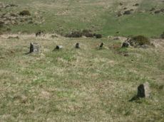
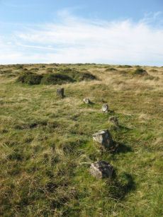
Black Tor (Avon) Stone Row
OS Map: SX 67730 63494
HER: MDV28589
Megalithic Portal: 1772
The Stone Rows of GB: Black Tor Avon Stone Row
PMD: Black Tor Avon Stone Row
ShortName: SR Black Tor
Butler map: 57.25
DPD page: 85
Notes: "A stone row running north west - south east seen on the plateau west of Black Tor". The stones are very hidden and difficult to see. The row is headed at the NW end by two small cairns. Lethbridge suggests remains of cist in one of them, diagram p.85. See also HER 5752, SX 66 SE 89 and SX 66 SE 33. NB. There is also a possible second row about 200 metres away SiteID=1320
Nearby sites: SX 67730 63494
Distance: 0.77km
Black Tor (Avon) 2 Stone Row
OS Map: SX 675 635
HER: MDV5752
The Stone Rows of GB: Black Tor Avon Stone Row
PMD: Black Tor Avon Stone Row
Alternate name: Black Tor (Avon) Stone Row
ShortName: SR:BlackTor2
Butler map: 57.25
Barrow Report: 4
Notes: "A stone row is alleged at this location by Worth (1932-33) but has not been located since, either by Worth, or during field investigation."
"In August 1932 author was present at a field meeting led by R.H. Worth who pointed out a single stone row, more or less east to west with a low barrow at each end, he had discovered near the summit of Black Tor in the Avon Valley.
Worth later contacted Quinnell to say he had been unable to locate it on a second visit. Quinnell also failed to locate it again, despite searching on at least six occasions 'had it not been that I and some 20 persons saw it in 1932 I would doubt its existence'."
Another reported stone row was reported by R.N. Worth in 1882 (see barrow Report 4)
"Worth, R. N., 1882, 4th Report of the Barrow Committee, 157 (Article in Serial). STONE ROW, BLACK TOR.
Nearly a furlong from the Tor in the glen below, on the eastern bank of the stream, are a pair of avenues which are only 40 feet apart and run parallel to each other east and west. They are formed of stones 2.5 feet high and each is terminated at the eastern end by a circle 36 feet in diameter consisting, of 15 stones enclosing a cairn. Between the northern avenue and the stream is a cairn while another, very imperfect, will be observed at end of southern avenue (citing Row's Perambulation, Second Edition, pgs 205-6)."
See also: HER MDV132249, MDV28589
Nearby sites: SX 675 635
Distance: 0.61km
Brent Fore Hill Stone Row
Prehistoric Dartmoor Walks: Dartmoor Walk: The Neolithic tombs of Cuckoo Ball & Corringdon Ball
OS Map: SX 66848 61345
HER: MDV5765
Megalithic Portal: 1777
The Stone Rows of GB: Brent Fore Hill
PMD: Brent Fore Hill Stone Row
ShortName: SR Brent Fore
Butler map: 56.10
DPD page: 83
Barrow Report: 66
Notes: "The remains of a stone row and cairn on Brent Fore Hill. The row is crossed by two leats, one of which is now disused. The cairn is visible as a low mound of turf-covered stones of 13.5 metres in diameter and 0.3 metres high". Lethbridge East Glaze Brook stone row p.83. See also: Sea Views at Brent Fore Hill
Nearby sites: SX 66848 61345
Distance: 1.69km
Brent Forehill Encircled Cairn
Prehistoric Dartmoor Walks: Dartmoor Walk: The Neolithic tombs of Cuckoo Ball & Corringdon Ball
OS Map: SX 66854 61356
HER: MDV13282
Megalithic Portal: 1777
PMD: Brent Fore Hill Stone Row
Alternate name: Brent Fore Hill stone row Encircled Cairn
ShortName: EC BrentForeSR
Butler map: 56.10
Grinsell: BRE 8
Turner: F23
Barrow Report: 66
Notes: The remains of a stone row and cairn on Brent Fore Hill. The row is crossed by two leats, one of which is now disused. The cairn is visible as a low mound of turf-covered stones of 13.5 metres in diameter and 0.3 metres high. Photo shows 2 or 3 stones of the cairn - it is not very photogenic! Turner F23.
Nearby sites: SX 66854 61356
Distance: 1.68km
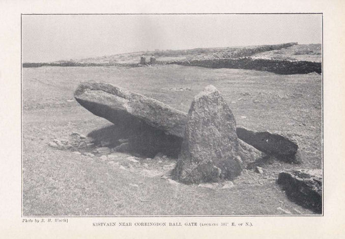
Brent Moor House Cist
OS Map: SX 6802 6403
HER: MDV5744
Megalithic Portal: 45754
PMD: Brent Moor House
ShortName: CT:Brent Moor
Grinsell: BRE 3
Barrow Report: 65 66
Notes: "A cist lies on the right bank of the Avon, a short distance above Brent Moor House, about 175 feet below the small stream which flows south of Riders Rings ... The cist, which consists of two end stones and one side stone, stands in a small cairn." Doubtful. (grinsell) "supposed cairn of large stones, enclosing possible cist placed se-nw. The whole area is covered with clitter, and it is possible that the site may be natural. In summer it is under dense bracken. No measurements given." Butler Vol. 4. Map 57.9 (not actually covered in Butler but relevant map). " A Medieval or later tinner's cache situated opposite Woolholes on the west bank of the River Avon. Considered under the Monument Protection Programme by previous Monument Protection Programme Advisor who did not recommend it for scheduling."
Nearby sites: SX 6802 6403
Distance: 1.35km
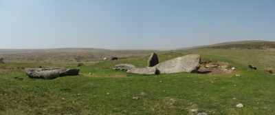
Corringdon Ball Chambered Tomb
Prehistoric Dartmoor Walks: Dartmoor Site: Corringdon Ball Chambered Tomb & Stone Rows
OS Map: SX 66956 61300
HER: MDV5750
Megalithic Portal: 4619
PMD: Corringdon Ball Chambered Cairn
Alternate name: Corringdon Ball chambered tomb Chambered Tomb
ShortName: NT Corringdon
Butler map: 56.10
Butler Vol 5: p.155
DPD page: 83
Grinsell: A:BRE 1
Barrow Report: 28 56 66
Notes: "An earthen long barrow with a ruined stone chamber at the south east end. Early excavation and mutilation has resulted in two distinct mounds, the larger one at the south east end separated from the smaller by a path or trackway. The smaller mound appears to mark the limit of the barrow on the northwest; beyond this it merges into the natural hill-side. There are no side ditches but these may be obscured by soil washed down from the hill. The length is 42.0 m; the maximum width is 18.0m and the maximum height of 2.4m."
Nearby sites: SX 66956 61300
Distance: 1.72km
Corringdon Ball Ceremonial Complex
Prehistoric Dartmoor Walks: Dartmoor Site: Corringdon Ball Chambered Tomb & Stone Rows
OS Map: SX 6666 6121
HER: MDV15960
Megalithic Portal: 10454
ShortName: CX CorringdonB
Notes: Close to the Corringdon Ball Chambered Tomb is a complex of multiple rows and numerous multiple ringed cairns.
Nearby sites: SX 6666 6121
Distance: 1.86km
Corringdon Ball Multiple Cairn Circle
Prehistoric Dartmoor Walks: Dartmoor Site: Corringdon Ball Chambered Tomb & Stone Rows
OS Map: SX 66665 61215
HER: MDV15960
Megalithic Portal: 52282
PMD: Corringdon Ball B
Alternate name: Corringdon Ball 5 Cairn Circle
ShortName: CC Corringdon
Butler map: 56.8.5
DPD page: 82
Notes: Five monuments noted by robinson and greeves at the ne end of the stone rows. Many have multiple concentric circles of small stones. Includes 3 cairns. See also entries for Corringdon Ball Stone Rows and East Glazebrook Encircled Cairn. Lethbridge p.82-3.
Nearby sites: SX 66665 61215
Distance: 1.86km
Corringdon Ball N. Stone Row
Prehistoric Dartmoor Walks: Dartmoor Site: Corringdon Ball Chambered Tomb & Stone Rows
OS Map: SX 66661 61206
HER: MDV5656
Megalithic Portal: 1856
The Stone Rows of GB: Corringdon Ball North
PMD: Corringdon Ball A Stone Row
Alternate name: Corringdon Ball North Stone Row
ShortName: SR CorringdonN
Butler map: 56.8.2
DPD page: 82
Barrow Report: 66
Notes: "A single stone row, length 157 metres, spacing 1.0 metres, starting on the east with a cairn, diameter 6.7 metres, previously opened. The first stone of the row lies 18 metres west of the cairn's centre; there has been considerable robbery for the benefit of modern stone walls. The row clearly extends for 157 metres from the centre of the cairn, but with long intervals between the last stones. The stones are small, the highest being 635 millimetres." See also entry for Corringdon Ball Row B. p.82
Nearby sites: SX 66661 61206
Distance: 1.87km
Corringdon Ball S. Stone Row
Prehistoric Dartmoor Walks: Dartmoor Site: Corringdon Ball Chambered Tomb & Stone Rows
OS Map: SX 66684 61205
HER: MDV5655
Megalithic Portal: 1857
The Stone Rows of GB: Corringdon Ball South
PMD: Corringdon Ball B Stone Row
Alternate name: Corringdon Ball South Stone Row
ShortName: SR CorringdonS
Butler map: 56.8.1
DPD page: 82
Barrow Report: 66
Notes: "Corringdon ball stone rows. Six or seven rows of small stones approximately 75m long, terminating at the east end in a small semi-circular stone setting of five stones, none more than 500mm high, and the alignments are irregular - they run along the contours. Situated on the open moor between the east and west glaze brooks. A complicated set of stones which can only be aligned into rows by exact survey. The direction of the rows is approximately south west". Described by R H Worth as two triple rows B & C. See also HER 14802 (Corringdon Ball B).
Nearby sites: SX 66684 61205
Distance: 1.86km

East Glazebrook Platform Cairn Circle
Prehistoric Dartmoor Walks: Dartmoor Walk: The Neolithic tombs of Cuckoo Ball & Corringdon Ball
OS Map: SX 66623 61237
HER: MDV15960
Megalithic Portal: 808
Alternate name: Corringdon Ball 6 Platform Cairn Circle
ShortName: PC E Glaze Row
Butler map: 56.8.6
Grinsell: UGB 3a
Turner: E50
Barrow Report: 68
Notes: Platform Cairn with Outer Stone Circles. "A ruined cairn with a very stony centre and the remains of multiple concentric rings of small stones visible on the south side. A substantial bank survives on the north side." Lethbridge p.82
Nearby sites: SX 66623 61237
Distance: 1.85km
East Glazebrook Encircled Cairn
Prehistoric Dartmoor Walks: Dartmoor Site: Corringdon Ball Chambered Tomb & Stone Rows
OS Map: SX 66679 61215
HER: MDV15961
Megalithic Portal: 3160
PMD: Corringdon Ball C Stone Row
Alternate name: Corringdon Ball stone rows 1 Encircled Cairn
ShortName: EC East Glaze
Butler map: 56.8.1
DPD page: 82
Grinsell: UGB 4
Turner: F14
Barrow Report: 66 68
Notes: Cairn at east end of the Corringdon Ball group of multiple stone rows . Six pillars of the retaining circle are clearly visible. For more detail see entries for the Corringdon Ball rows.
Nearby sites: SX 66679 61215
Distance: 1.85km
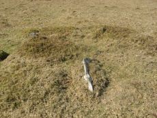
Hickley Ridge Central Cist
OS Map: SX 67224 62250
HER: MDV61772
Megalithic Portal: 45810
PMD: Hickley Ridge Central
Alternate name: Hickley Ridge 2 Cist
ShortName: CT HickleyCe
Butler map: 56.14.3
Butler Vol 5: p.175 & Fig.117
DPD page: 84
Notes: Butler Hickley Ridge Cairn and Cist 2. 56.14.3 diagram Vol 5 p.175. "Two slabs, possibly of a cist, embedded in low mound south of the leat on Hickley Ridge." Lethbridge diagram p.84, photo bottom left.
Nearby sites: SX 67224 62250
Distance: 0.77km
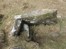
Hickley Ridge E Cist
OS Map: SX 67402 62381
HER: MDV61773
Megalithic Portal: 45811
PMD: Hickley Ridge E.
Alternate name: Hickley Ridge 1 Cist
ShortName: CT HickleyE
Butler map: 56.14.2
Butler Vol 5: p.175 & Fig.116
DPD page: 84
Notes: Butler Hickley Ridge Cist 1. 56.14.3 diagram Vol 5 p.175. "One side and one end slab of cist on Hickley Ridge, with other fallen stones in the mound. One of three badly damaged cists aligned south-west to north-east across Hickley Ridge, recognised by Butler in 1995." Lethbridge diagram and photo on right of p.84.
Nearby sites: SX 67402 62381
Distance: 0.69km
Hickley Ridge W Cist
OS Map: SX 6659 6203
HER: MDV13283
Megalithic Portal: 45809
PMD: Hickley Ridge W.
Alternate name: Hickley Ridge 3 Cist
ShortName: CT:HickleyW
Butler map: 56.14.4
Butler Vol 5: p.176 & Fig.118
DPD page: 84
Notes: "Cairn and cist on the East side of Brent Fore Hill. The cairn is 6.0m in diameter, merging into the slope of the hill and being about 0.5m high on the downslope side, which has a retaining kerb. There is a central cist of which two parallel slabs remain set on edge at the NW and SE sides. An upright stone 0.9m high is offset from the cist on the NW side." Lethbridge p.84 diagram and photo top left. Butler Hickley Ridge 3 56.14.4 diagram Vol 5 p.176.
Nearby sites: SX 6659 6203
Distance: 1.12km
Knatta Barrow Stone Ring Cairn Circle
OS Map: SX 65970 64212
HER: MDV5717
Megalithic Portal: 45842
ShortName: RC:Knatta Bar.
Butler map: 57.29
Butler Vol 5: p.160 & Fig.102
Grinsell: BRE 2
Turner: A54
Notes: "This large cairn (24m diameter, 1.7m height) composed of loose granite boulders. It is unusual among summit cairns in having a well defined outer bank about 1m wide and 0.5m high. This is partly turf covered but where eroded can be seen to be built of loose stone like the central cairn which touches it. It shows best on the north and east sides, while on the south west side it tends to merge into the body of the cairn."
Nearby sites: SX 65970 64212
Distance: 1.67km
Riders Rings Enclosed Settlement
OS Map: SX 67870 64359
HER: MDV5767
Megalithic Portal: 45321
ShortName: ES RidersRings
DPD page: 85
Notes: "The largest and most important pound in the Avon Valley. Situated on the eastern slope of Zeal Plains. It is best regarded as being two contiguous pounds, of which it would appear that the south west member was constructed first, while the north east member was added as a later extension. The two pounds together cover an area of over six acres and enclose some three dozen hut-circles". Lethbridge p.85
Nearby sites: SX 67870 64359
Distance: 1.54km
Three Barrows Cairn
Prehistoric Dartmoor Walks: Dartmoor Walk: The Erme East stone rows
OS Map: SX 65315 62601
HER: MDV5666
Megalithic Portal: 45593
PMD: Three Barrows NW
Alternate name: Three Barrows Central Cairn
ShortName: CN 3 Barrows
Butler map: 54.20
Butler Vol 5: p.53
Grinsell: BRE 6
Barrow Report: 1 56 63
Notes: "Three very large cairns known as the Three Barrows (see SX 66 SE 54, 56), one of which, being about 50 yards in diameter, and 8 feet high, is reputed to be perhaps the largest on Dartmoor". See also HER Southern cairn 5830 and HER Northern cairn 5746
Nearby sites: SX 65315 62601
Distance: 1.86km
Treeland Brake Stone Row
OS Map: SX 6741 6158
HER: MDV5827
Megalithic Portal: 6333473
The Stone Rows of GB: Treeland Brake
PMD: Treeland Brake Stone Row
ShortName: SRxTreeland Bk
Butler map: 56.11
Notes: Notes from the NMR record: "Treeland Brake Stone Row. The only record of the row is a photograph taken by Mr HG Hurrell in the late 1950s. Mr Hurrell remembers about five erect stones and about five fallen, aligned north-east to south-west. The row has been destroyed by agricultural activity by 1977. (Photograph is in the possession of S & M Register)." Also: "A colour print taken by Mr Hurrell from approximately SX 67206130 shows the stones aligned to a field corner at SX 67296147. Approximate centre of row, SX 67276141; the area is now under pasture."
Nearby sites: SX 6741 6158
Distance: 1.46km
Upper Glazebrook Neolithic Enclosure
Prehistoric Dartmoor Walks: Dartmoor Site: Corringdon Ball Chambered Tomb & Stone Rows
OS Map: SX 6636 6126
HER: MDV5692
Megalithic Portal: 45594
ShortName: NE Upper Glaze
Butler Vol 5: p.155
Notes: A rectangular enclosure not far from Corringdon Ball chambered tomb measuring 112m by 34m that can be seen clearly on aerial and satellite photos of the area. The walls are up to 1.5m thick and 0.3m high, and have been entirely destroyed on the east and north-west sides. There is no obvious entrance and the interior is empty of any structure. According to Butler the east to west orientation of the long axis could suggest a mortuary enclosure of mid-neolithic date (Vol 5 pp.155-6).
Nearby sites: SX 6636 6126
Distance: 1.91km