
Guide to the Monuments on Ugborough Moor and Corringdon Ball
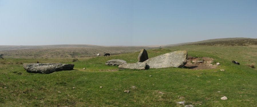
Table of Ritual and Burial Monuments on Ugborough Moor and Corringdon Ball
The following table lists the records currently in this Guide Map. For an explantion of the Guide Maps and a table of all 62 Guide Maps, follow this link: Guide List Table. Introductory text will be added to each guide list in 2025. Notes on duplication and omissions will appear below the table once checks have been finalised.
Notes on possible duplications and omissions
NB. Piles Hill S.W. cairns: Some of the 18 cairns are to be found on Guide to the Monuments on Butterdon HillSharp Tor (duplicate): This HER entry, MDV4308 (Sharp Tor (duplicate)), refers to the list of cairns in the 21st barrow report p. 139. That in turn refers to Barrow Report 4, T.D.A. Vol.14 (1882) which is a description of MDV5764 (Sharp Tor) - the large cairn on Sharp Tor. Clearly this is a duplicate.
Glasscombe Ball S1 and S2: There are a pair of stoney mounds separated by approx. 100 metres. Butler refers to one of them and there is one entry on the HER. The HER states The date or purpose of this cairn cannot be determined visually but the impression is that it is a doubtful antiquity.. That is correct but there are two of them. The records above have the grid references and photos of both taken on the same day. Recommend the HER record be updated to reflect the two very similiar and nearby features.
NB. Crossing and Lethbridge entries: The other two entries here without corresponding HER entries probably don't qualify for the HER. One relates to Grinsell reporting and observation by Crossing and the other is a claimed cist reported by Lethbridge. If the Lethbridge feature is confirmed by fieldwork then it will be worth adding.
PS. These notes are to assist untangling complicated records and are neither permanent nor a criticism of the HER who do a fantastic job! The author finds it easier to systematically work through these records (2000+ of them) and add these notes, which are then to be communicated with the HER, if appropriate, it is a pragmatic way of dealing with lots of data without continually stopping and starting.
Ugborough Moor and Corringdon Ball Guide Map
Guidance for walkers: The monuments featured in this database are archaeological treasures and need to be protected and preserved - please do not disturb any sites. Please check access and firing times before visiting sites, not all sites listed are on open access land. Firing ranges and boundaries of open access areas are marked on the OL28 OS Dartmoor Explorer map. Please stick to the country code and consider giving support to the numerous agencies that help to keep Dartmoor a fabulous natural and historic environment!
List of Ritual and Burial Monuments on Ugborough Moor and Corringdon Ball
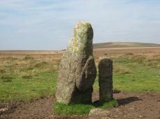
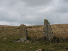
Piles Hill Standing Stone
OS Map: SX 65433 60746
HER record: MDV5653
Megalithic Portal: 10003
PMD: Piles Hill Standing Stone
ShortName: SS Piles Hill
Butler map: 53.8
DPD page: 77
Notes: The fallen menhir on Piles Hill: "The 'Longstone' is a block of very coarse-grained pinkish granite. It is now 2.5m long and of rough rectangular section tapering from a base formerly about 0.4m. by 0.7m. which has been squared and snapped by drilling. The stone lies in a northwest to southeast direction. To its northeast side there is a boundary stone erected in 1803 and shaped by drilling. It is of identical stone and appears to have been fashioned from the 'Longstone' which would therefore have originally been some 4.5m long." Lethbridge p.77
Nearby sites: SX65436075
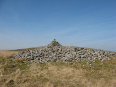
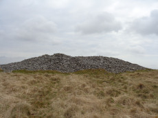
Sharp Tor Cairn
OS Map: SX 65004 61796
HER record: MDV5764
ShortName: CN Sharp Tor 1
Butler map: 53.8.4
Grinsell: HAR 9
Notes: "This large cairn close to the summit of Sharp Tor is 25m in diameter and approximately 1.8m. high. It is built of stones on an earth and stone base the circumference of which projects beyond the stones. Rushes and other vegetation suggest the presence of a ditch around the mound."
Nearby sites: SX65006180
Sharp Tor (duplicate) Reported Cairn
OS Map: SX 64900 61700
HER record: MDV4308
ShortName: CN:Sharp Tor 2
Notes: HER record includes reference to barrow report 21 which just lists the cairns known at the time. Clearly a duplicate.
Nearby sites: SX64906170
Sharp Tor N Reported Cairn
OS Map: SX 64993 61913
HER record: MDV13486
ShortName: CN Sharp Tor N
Grinsell: HAR 9a
Notes: Circle of seven stones, measuring around 8.0 metres in diameter, with a possible stone alignment of three stones leading north-east from the circle.
Nearby sites: SX64996191
Sharp Tor North East Stone Row
OS Map: SX 65000 61880
HER record: MDV13486
The Stone Rows of GB: Sharp Tor North East
PMD: Sharp Tor NE. Stone Row
Alternate name: Sharp Tor NE Stone Row
ShortName: SR:Sharp Tor N
Notes: HER: "Circle of seven stones, measuring around 8.0 metres in diameter, with a possible stone alignment of three stones leading north-east from the circle." See also linked entry on SRGB which states "Dense vegetation made it difficult to be certain that there was a stone row row at this location."
Nearby sites: SX65006188
Sharp Tor Standing Stone
OS Map: SX 65100 61900
HER record: MDV5709
ShortName: SS:Sharp Tor
Notes: NGR is estimated. Source Worth, HER: Sharp tor. Alongside one of the modern boundary stones lies what may be a fallen menhir. See The Dartmoor Menhirs p.193
Nearby sites: SX65106190
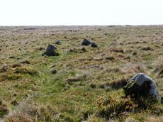
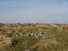
Piles Hill S.W.10 Clearance Cairn
OS Map: SX 64970 60010
HER record: MDV13483
ShortName: CN?PilesHill10
Butler map: 53.11.10
Notes: Butler describes as cairn. However, possibly a clearance cairn associated withthe `Bulllaven Reave'. This area has very many patches of gorse that look like they could conceal a mound but could just be vegetation. This makes identifying claimed cairns very difficult. The author looked for this cairn on 20/04/2019 and was unable to find it.
Nearby sites: SX64976001
Piles Hill S.W.11 Clearance Cairn
OS Map: SX 65130 60040
HER record: MDV27912
ShortName: CN?PilesHill11
Butler map: 53.11.11
Notes: Butler describes as cairn. However, possibly a clearance cairn associated withthe `Bulllaven Reave'. This area has very many patches of gorse that look like they could conceal a mound but could just be vegetation. This makes identifying claimed cairns very difficult. The author looked for this cairn on 20/04/2019 and was unable to find it.
Nearby sites: SX65136004
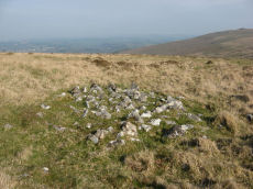
Piles Hill S.W.12 Cairn
OS Map: SX 64914 60068
HER record: MDV130016
ShortName: CN PilesHil112
Butler map: 53.11.12
Grinsell: HAR 24
Notes: Sited on a hill slope at the juncion of two reaves. This area has very many patches of gorse that look like they could conceal a mound but could just be vegetation. This makes identifying claimed cairns very difficult. The author looked for this cairn on 20/04/2019 and found this. The mound is long and thin and consistent with a fragmentary section of a reave rather than a cairn.
Nearby sites: SX64916007
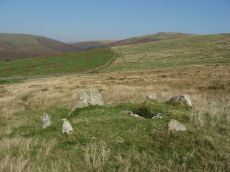
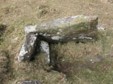
Lower Piles Ring Setting Cairn and Cist
OS Map: SX 64540 60262
HER record: MDV4256
Megalithic Portal: 1108
PMD: Lower Piles
Alternate name: Piles Hill S.W.15 Ring Setting Cairn and Cist
ShortName: CT Lower Piles
Butler map: 53.11.15
DPD page: 76
Grinsell: HAR 8
Turner: D13
Barrow Report: 36 62
Notes: "A cist with a retaining circle, diameter 14 to 15 feet, of which seven stones still remain, lies about 150 yds south of the south east angle of Lower Piles enclosure. The cist measures 3 feet 7 inches in length by 1 foot 4 inches wide at the south-eastern end and 2 feet wide at the north western. The present depth is from 2 feet 9 inches to 3 feet. The cover-stone and the north-western end-stone are missing." Letchfield diagram p.76. Barrow Report 36 says "To the south-east, in the direction of the length of the kistvaen, stands a single large stone, about 100 feet distant; to the north-west, with its centre 110 feet away from the centre of the kistvaen, there is a small cairn of 20 feet diameter; this also is in the line of the length of the kistvaen." The stone is at SX 64518 60236 Butler Piles Hill S.W. - Vol. 4. Map 53.11.15 (p.33 diagram of cist & plan of cairns on Piles Hill p.30).
Nearby sites: SX64546026
Piles Hill S.W.16 Cairn
OS Map: SX 64522 60293
HER record: MDV4305
ShortName: CN PilesHill16
Butler map: 53.11.16
Grinsell: HAR 7
Barrow Report: 36
Nearby sites: SX64526029
Piles Hill S.W.17 Clearance Cairn
OS Map: SX 64610 60100
HER record: MDV130029
ShortName: CN?PilesHill17
Butler map: 53.11.17
Notes: Butler describes as cairn. However, possibly a clearance cairn associated with the Bulllaven Reave.
Nearby sites: SX64616010
Piles Hill S.W.18 Clearance Cairn
OS Map: SX 64670 60040
HER record: MDV130030
ShortName: CN?PilesHill18
Butler map: 53.11.18
Notes: Butler describes as cairn. However, possibly a clearance cairn associated with the 'Bulllaven Reave'.
Nearby sites: SX64676004
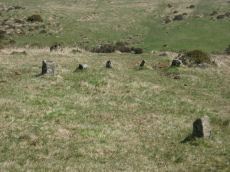
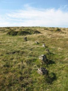
Piles Hill Stone Row
OS Map: SX 65016 61113
HER record: MDV5662
Megalithic Portal: 2080
The Stone Rows of GB: Piles Hill
PMD: Piles Hill Stone Row
ShortName: SR Piles Hill
Butler map: 54.19
DPD page: 74
Notes: "The double stone row formed by 139 stones, 7 of which lean; the others are either stumps with drill marks, cleanly snapped off stones, or recumbent posts, whole or split by drilling. Some 30 stones exceed 2.0m. in length with a maximum of 3.0m. A few take the form of slabs or boulders but the majority are of post-type up to 0.6m. square in section, with an angled top created by a single 'chamfer'. The rows in the main alignment are from 21.0m. to 30.0m. apart and within them the gaps between stones vary from 3.0m. to 30.0m. At each end the rows are close, 12.0m. to 17.0m. apart with fewer large gaps between stones". Lethbridge pp.74-6, diagram p.74.
Nearby sites: SX65026111
Piles Hill Stone Ring Cairn Circle
OS Map: SX 65334 60849
HER record: MDV5763
Megalithic Portal: 10030
Alternate name: Piles Hill Summit Stone Ring Cairn Circle
ShortName: RC:Piles Hill
Butler map: 54.19
Butler Vol 5: p.162 & Fig.103
Grinsell: HAR 12
Turner: A53
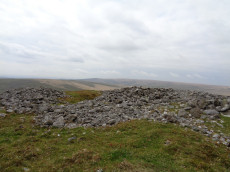
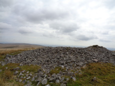
Notes: Bell cairn of Wessex type. "Cairn on piles hill. An unusual monument, the equivalent of a bell barrow in stone. Cairn (diam 17.8m, heig 1.37m), berm(widt 3.05m), stone circle (diam 2.1m, heig 457mm)vis=12/4/1950 (os). Cairn with bell disc features. Slight hollow in the centre of the tump (mound), otherwise in good condition. No distinct outer bank could be found, but the berm and central tump were quite evident."
Nearby sites: SX65336085
Piles Brook 1 Reported Cairn
OS Map: SX 64900 61100
HER record: MDV16518
ShortName: CN:Piles Bk 1
Nearby sites: SX64906110
Piles Brook 2 Cairn
OS Map: SX 64542 61085
HER record: MDV34252
ShortName: CN:Piles Bk 2
Nearby sites: SX64546109
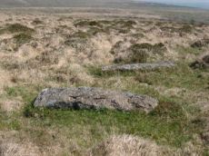
Piles Brook Head Reported Cairn
OS Map: SX 65048 61118
HER record: MDV132268
ShortName: CN-Piles Bk 3
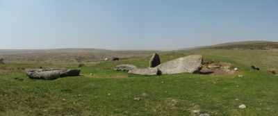
Notes: The NMR record states: "High on the valley side a little to the South of the hallow of Piles Brook Head are the unrecorded relics of a dalmen. Of the two remaining uprights, one leaning, the other fallen, the longer measures 7 feet 6 inches and the smaller 4 feet 4 inches in length. Traces of a barrow are slight. (The caption to plate 153 reads "traces of a long barrow are slight.")".
The stone that was still standing fell in recent years and both have now been restored - see photo. This is clearly not a dolmen or cairn but the spectacular start of what would probably once have been the most impressive double stone rows on the moor.
Nearby sites: SX65056112
Piles Hill N.1 Cairn
OS Map: SX 65360 61041
HER record: MDV13485
ShortName: CN Piles N1
Butler map: 54.19.1
Grinsell: HAR 10
Notes: "Cairn found. Grass covered. Diameter 10m, height 0.3m."
Nearby sites: SX65366104
Piles Hill N.2 Cairn
OS Map: SX 65330 61002
HER record: MDV5708
ShortName: CN Piles N2
Butler map: 54.19.2
Grinsell: HAR 11
Notes: "Resistance survey convincing detected a low-resistance ring around this cairn; likely encircling ditch. Magnetic survey detected a short arcing anomaly west of the cairn, which may or may not be related" (2022)
Nearby sites: SX65336100

Piles Hill N.3 Cairn
OS Map: SX 65355 60933
HER record: MDV25676
ShortName: CN Piles N3
Butler map: 54.19.3
Notes: HER Small undisturbed mound at SX65326083 of 3 metres diameter by 0.2 metres high 20 metres north of the summit cairn on Piles Hill.
Nearby sites: SX65366093
Piles Hill N.4 Reported Cairn
OS Map: SX 65400 60960
HER record: MDV25678
ShortName: CN:Piles N4
Notes: This HER record is from an aerial photograph from about 1980. The author was unable to find a site that matches this record. Possible cairn, possibly one of a group of cairns. Visible on 1980 nmr ap.(rchm app 1985)
Nearby sites: SX65406096
Piles Hill N.5 Reported Cairn
OS Map: SX 65360 60970
HER record: MDV25684
ShortName: CN:Piles N5
Notes: This HER record is from an aerial photograph from about 1980. The author was unable to find a site that matches this record. Possible cairn, possibly one of a group of cairns. Visible on 1980 nmr ap.(rchm app 1985)
Nearby sites: SX65366097
Three Barrows Cairn
OS Map: SX 65315 62601
HER record: MDV5666
Megalithic Portal: 45593
PMD: Three Barrows NW
Alternate name: Three Barrows Central Cairn
ShortName: CN 3 Barrows
Butler map: 54.20
Butler Vol 5: p.53
Grinsell: BRE 6
Barrow Report: 1 56 63
Notes: "Three very large cairns known as the Three Barrows (see SX 66 SE 54, 56), one of which, being about 50 yards in diameter, and 8 feet high, is reputed to be perhaps the largest on Dartmoor". See also HER Southern cairn 5830 and HER Northern cairn 5746
Nearby sites: SX65326260
Three Barrows N.W. Cairn
OS Map: SX 65220 62648
HER record: MDV5746
ShortName: CN Three Bar2
Butler map: 54.20
Butler Vol 5: p.53
Grinsell: UGB 1
Barrow Report: 1
Nearby sites: SX65226265
Three Barrows S.E. Cairn
OS Map: SX 65352 62540
HER record: MDV5830
ShortName: CN Three Bar3
Butler map: 54.20
Butler Vol 5: p.53
Grinsell: BRE 7
Barrow Report: 56
Nearby sites: SX65356254
Three Barrows W. Cairn
OS Map: SX 64527 62973
HER record: MDV4287
ShortName: CN:Three Bar4
Butler map: 54.9
Grinsell: HAR 4
Nearby sites: SX64536297
Three Barrows (SSE of) Clearance Cairn
OS Map: SX 65500 62300
HER: No record found
ShortName: CN?3BarsSSE
Grinsell: B:BRE 7a
Notes: Small cairn (Crossing 1912/1965, 380). No sign of this cairn.
Nearby sites: SX65506230
Red Brook Cairn
OS Map: SX 65560 62950
HER record: MDV13280
ShortName: CN:Red Brook
Nearby sites: SX65566295

Lower Glasscombe Cist
OS Map: SX 66506 60502
HER record: MDV5652
Megalithic Portal: 45761
PMD: Lower Glasscombe
Alternate name: Glaze Meet Cist
ShortName: CT Lower Glass
Butler map: 56.3
DPD page: 81
Grinsell: UGB 11
Barrow Report: 72
Notes: "There is a very slight trace of a mound and scattered rocks indicate the remains of a cairn ... Only one sidestone and one endstone now remain with the coverstone lying 11 feet away to the south-east. Overall dimensions of the coverstone are 49 inches by 24 inches". Lethbridge Scad Brook cist p.81 Butler Glaze Meet - Vol. 4. Map 56.3 (diagram p.85).
Copyright for photos and plans from Barrow Reports 71-73 belong to the Dixon estate. Reproduced here with kind permission.
Nearby sites: SX66516050
Glaze Meet (possible cist) Reported Cist
OS Map: SX 66300 60300
HER: No record found
ShortName: CT?Glaze Mee2
Notes: Lethbridge Discover Prehistoric Dartmoor p.81. Cist? In diagram - no explanation in text. Approx NGR from diagram of SX663603
Nearby sites: SX66306030
Piles Hill E. Reported Cairn
OS Map: SX 65790 61000
HER record: MDV28482
PMD: Glasscombe Corner
ShortName: CT?Piles Hil3
Butler map: 56.5
Butler Vol 5: p.59 & Fig.36
Grinsell: UGB 1a
Notes: SX 65796100 A group of stones, doubtfully remains of cairn with cist, first noted by Worth.
Nearby sites: SX65796100
Corringdon Ball Ceremonial Complex
OS Map: SX 66660 61210
HER record: MDV129970
Megalithic Portal: 10454
ShortName: CX CorringdonB
Notes: Close to the Corringdon Ball Chambered Tomb is a complex of multiple rows and numerous multiple ringed cairns.
Nearby sites: SX66666121
Upper Glazebrook Neolithic Enclosure
OS Map: SX 66360 61260
HER record: MDV5692
Megalithic Portal: 45594
ShortName: NE Upper Glaze
Butler Vol 5: p.155
Notes: A rectangular enclosure not far from Corringdon Ball chambered tomb measuring 112m by 34m that can be seen clearly on aerial and satellite photos of the area. The walls are up to 1.5m thick and 0.3m high, and have been entirely destroyed on the east and north-west sides. There is no obvious entrance and the interior is empty of any structure. According to Butler the east to west orientation of the long axis could suggest a mortuary enclosure of mid-neolithic date (Vol 5 pp.155-6).
Nearby sites: SX66366126
Brent Fore Hill S.1 Cairn
OS Map: SX 66879 61133
HER record: MDV13284
ShortName: CT?BrentForeS1
Butler map: 56.10
Grinsell: BRE 8a
Notes: A cairn consisting of a turf-covered mound, diameter 7.0m. and height 0.3m. with five stones of a possible retaining circle in situ. There is a depression in the centre revealing a stone resembling the east end stone of a cist.
Nearby sites: SX66886113
Brent Fore Hill S.2 Reported Cairn
OS Map: SX 66800 61430
HER record: MDV30127
ShortName: CN:BrentForeS2
Butler map: 56.7.2
Notes: Butler describes 3 cairns here
Nearby sites: SX66806143
Brent Fore Hill S.3 Reported Cairn
OS Map: SX 66770 61420
HER record: MDV130049
ShortName: CN:BrentForeS3
Butler map: 56.7.3
Notes: Butler describes 3 cairns here
Nearby sites: SX66776142
Brent Fore Hill S.4 Reported Cairn
OS Map: SX 66750 61430
HER record: MDV130050
ShortName: CN:BrentForeS4
Butler map: 56.7.4
Notes: Butler describes 3 cairns here
Nearby sites: SX66756143
Corringdon Ball S. Stone Row
OS Map: SX 66684 61205
HER record: MDV5655
Megalithic Portal: 1857
The Stone Rows of GB: Corringdon Ball South
PMD: Corringdon Ball B Stone Row
Alternate name: Corringdon Ball South Stone Row
ShortName: SR CorringdonS
Butler map: 56.8.1
DPD page: 82
Barrow Report: 66
Notes: "Corringdon ball stone rows. Six or seven rows of small stones approximately 75m long, terminating at the east end in a small semi-circular stone setting of five stones, none more than 500mm high, and the alignments are irregular - they run along the contours. Situated on the open moor between the east and west glaze brooks. A complicated set of stones which can only be aligned into rows by exact survey. The direction of the rows is approximately south west". Described by R H Worth as two triple rows B & C. See also HER 14802 (Corringdon Ball B).
Nearby sites: SX66686121
East Glazebrook Encircled Cairn
OS Map: SX 66679 61215
HER record: MDV129970
Megalithic Portal: 3160
PMD: Corringdon Ball C Stone Row
Alternate name: Corringdon Ball stone rows 1 Encircled Cairn
ShortName: EC East Glaze
Butler map: 56.8.1
DPD page: 82
Grinsell: UGB 4
Turner: F14
Barrow Report: 66 68
Notes: Cairn at east end of the Corringdon Ball group of multiple stone rows . Six pillars of the retaining circle are clearly visible. For more detail see entries for the Corringdon Ball rows.
Nearby sites: SX66686122
Corringdon Ball N. Stone Row
OS Map: SX 66661 61206
HER record: MDV5656
Megalithic Portal: 1856
The Stone Rows of GB: Corringdon Ball North
PMD: Corringdon Ball A Stone Row
Alternate name: Corringdon Ball North Stone Row
ShortName: SR CorringdonN
Butler map: 56.8.2
DPD page: 82
Barrow Report: 66
Notes: "A single stone row, length 157 metres, spacing 1.0 metres, starting on the east with a cairn, diameter 6.7 metres, previously opened. The first stone of the row lies 18 metres west of the cairn's centre; there has been considerable robbery for the benefit of modern stone walls. The row clearly extends for 157 metres from the centre of the cairn, but with long intervals between the last stones. The stones are small, the highest being 635 millimetres." See also entry for Corringdon Ball Row B. p.82
Nearby sites: SX66666121
Corringdon Ball stone row 2 Cairn
OS Map: SX 66640 61190
HER record: MDV15961
ShortName: CN:Corringdo2
Butler map: 56.8.2
Grinsell: UGB 3
Barrow Report: 66 68
Notes: See Barrow report 66.
Nearby sites: SX66646119
Corringdon Ball 3 Cairn
OS Map: SX 66650 61200
HER: No record found
ShortName: CN:Corringdo3
Butler map: 56.8.3
Notes: NMR A
Nearby sites: SX66656120
Corringdon Ball 4 Cairn
OS Map: SX 66650 61230
HER record: MDV15961
ShortName: CN:Corringdo4
Butler map: 56.8.4
Notes: NMR B
Nearby sites: SX66656123
Corringdon Ball Multiple Cairn Circle
OS Map: SX 66665 61215
HER record: MDV15960
Megalithic Portal: 52282
PMD: Corringdon Ball B
Alternate name: Corringdon Ball 5 Cairn Circle
ShortName: CC Corringdo5
Butler map: 56.8.5
DPD page: 82
Notes: Five monuments noted by robinson and greeves at the ne end of the stone rows. Many have multiple concentric circles of small stones. Includes 3 cairns. See also entries for Corringdon Ball Stone Rows and East Glazebrook Encircled Cairn. Lethbridge p.82-3.
Nearby sites: SX66676122

East Glazebrook Platform Cairn Circle
OS Map: SX 66623 61237
HER record: MDV15960
Megalithic Portal: 808
Alternate name: Corringdon Ball 6 Platform Cairn Circle
ShortName: PC Corringdo6
Butler map: 56.8.6
Grinsell: UGB 3a
Turner: E50
Barrow Report: 68
Notes: Platform Cairn with Outer Stone Circles. "A ruined cairn with a very stony centre and the remains of multiple concentric rings of small stones visible on the south side. A substantial bank survives on the north side." Lethbridge p.82
Nearby sites: SX66626124
Corringdon Ball 7 Cairn
OS Map: SX 66640 61230
HER record: MDV15961
ShortName: CN:Corringdo7
Butler map: 56.8.7
Notes: ? 2 cairns referred to but only 1 NGR
Nearby sites: SX66646123
East Glaze 1 Cairn
OS Map: SX 66464 61316
HER record: MDV28481
ShortName: CN:East Glaz1
Butler map: 56.9.1
Grinsell: UGB 2a
Nearby sites: SX66466132
East Glaze 2 Cairn
OS Map: SX 66377 61339
HER record: MDV5664
ShortName: CN East Glaz2
Butler map: 56.9.2
Grinsell: UGB 2
Nearby sites: SX66386134
West Glaze Reported Cairn
OS Map: SX 66270 61130
HER record: MDV130054
ShortName: CN?West Glaz1
Butler map: 56.9.3
Notes: Butler: "South-west halfway to Glasscombe Corner are is another disorgaized mound ... probably the remains of another cairn". Not listed on NMR or HER.
Nearby sites: SX66276113
Corringdon Ball Chambered Tomb
OS Map: SX 66956 61300
HER record: MDV5750
Megalithic Portal: 4619
PMD: Corringdon Ball Chambered Cairn
Alternate name: Corringdon Ball chambered tomb Chambered Tomb
ShortName: NT Corringdon
Butler map: 56.10
Butler Vol 5: p.155
DPD page: 83
Grinsell: A:BRE 1
Barrow Report: 28 56 66
Notes: "An earthen long barrow with a ruined stone chamber at the south east end. Early excavation and mutilation has resulted in two distinct mounds, the larger one at the south east end separated from the smaller by a path or trackway. The smaller mound appears to mark the limit of the barrow on the northwest; beyond this it merges into the natural hill-side. There are no side ditches but these may be obscured by soil washed down from the hill. The length is 42.0 m; the maximum width is 18.0m and the maximum height of 2.4m."
Nearby sites: SX66966130
Brent Fore Hill Stone Row
OS Map: SX 66848 61345
HER record: MDV5765
Megalithic Portal: 1777
The Stone Rows of GB: Brent Fore Hill
PMD: Brent Fore Hill Stone Row
ShortName: SR Brent Fore
Butler map: 56.10
DPD page: 83
Barrow Report: 66
Notes: "The remains of a stone row and cairn on Brent Fore Hill. The row is crossed by two leats, one of which is now disused. The cairn is visible as a low mound of turf-covered stones of 13.5 metres in diameter and 0.3 metres high". Lethbridge East Glaze Brook stone row p.83. See also: Sea Views at Brent Fore Hill
Nearby sites: SX66856135
Ball gate Cairn
OS Map: SX 66900 61320
HER record: MDV19901
ShortName: CT?Ball gate1
Notes: A cairn consisting of a turf-covered mound, diameter 7.0m. and height 0.3m. with five stones of a possible retaining circle in situ. There is a depression in the centre revealing a stone resembling the east end stone of a cist. Possible duplicate of Bre 8a / HER 13284 / NMR 901582?
Nearby sites: SX66906132
Brent Forehill Encircled Cairn
OS Map: SX 66854 61356
HER record: MDV13282
Megalithic Portal: 1777
PMD: Brent Fore Hill Stone Row
Alternate name: Brent Fore Hill stone row Encircled Cairn
ShortName: EC BrentForeSR
Butler map: 56.10
Grinsell: BRE 8
Turner: F23
Barrow Report: 66
Notes: The remains of a stone row and cairn on Brent Fore Hill. The row is crossed by two leats, one of which is now disused. The cairn is visible as a low mound of turf-covered stones of 13.5 metres in diameter and 0.3 metres high. Photo shows 2 or 3 stones of the cairn - it is not very photogenic! Turner F23.
Nearby sites: SX66856136
Brent Fore Hill nr Summit Cairn
OS Map: SX 66246 62190
HER record: MDV42317
ShortName: CN:BrentFore 1
Nearby sites: SX66256219
Ball Gate Stone Ring Cairn Circle
OS Map: SX 66996 61306
HER record: MDV7739
Megalithic Portal: 45839
PMD: Corringdon Ball Gate cairn
Alternate name: Corringdon Ball N. Stone Ring Cairn Circle
ShortName: RC Ball Gate
Butler map: 56.10
Grinsell: BRE 9
Turner: A43
Barrow Report: 28 66
Notes: "A very vague circle 21m diameter, which may be the remains of a mutilated cairn. Vis=-/4/1977 (ancient monuments) possibly rather damaged on one side. Vis=23/6/1973 (grinsell, l. V. ). Site of cairn almost levelled probably for material to build the adjoining wall. Shown on OS 6" as 'cairn circle'. Diameter 21m, height 0.4m. Vis=28/7/1977 (os) there is a gap in the rim on the southeast, probably for carts taking away the stone".
Nearby sites: SX67006131
Brent Fore Hill nr Summit (duplicate ) Reported Cairn
OS Map: SX 66200 62000
HER record: MDV13281
ShortName: CN:BrentFore 2
Notes: Duplicate of HER 42317
Nearby sites: SX66206200
Treeland Brake Stone Row
OS Map: SX 67410 61580
HER record: MDV5827
Megalithic Portal: 6333473
The Stone Rows of GB: Treeland Brake
PMD: Treeland Brake Stone Row
ShortName: SRxTreeland Bk
Butler map: 56.11
Notes: Notes from the NMR record: "Treeland Brake Stone Row. The only record of the row is a photograph taken by Mr HG Hurrell in the late 1950s. Mr Hurrell remembers about five erect stones and about five fallen, aligned north-east to south-west. The row has been destroyed by agricultural activity by 1977. (Photograph is in the possession of S & M Register)." Also: "A colour print taken by Mr Hurrell from approximately SX 67206130 shows the stones aligned to a field corner at SX 67296147. Approximate centre of row, SX 67276141; the area is now under pasture."
Nearby sites: SX67416158
Glasscombe Corner Stone Row
OS Map: SX 65997 60748
HER record: MDV5661
Megalithic Portal: 3254
The Stone Rows of GB: Glasscombe Corner
PMD: Glasscombe Corner Stone Row
ShortName: SR Glasscombe
Butler map: 56.12
Butler Vol 5: p.229 & Fig.162
DPD page: 81
Notes: "A stone row partly double and partly single ending on the remains of a cairn circle. The length of the double row is 111.0m. and of the single row 61.0m, the total length to the centre of the cairn circle being 177.0m". Lethbridge Avon Valley stone row pp.81-82, diagram p.81.
Nearby sites: SX66006075
Glasscombe Corner Cairn Circle
OS Map: SX 66100 60802
HER record: MDV49561
Megalithic Portal: 1951
PMD: Glasscombe Corner Stone Row
Alternate name: Glasscombe Corner stone row Cairn Circle
ShortName: CN GlasscombW1
Butler map: 56.12
Grinsell: UGB 5
Turner: G28
Notes: Lower end of stone row. "A stone row, 300 yds S 41o W from Glasscombe Corner. The southern 368 feet are a double row and the northern 212 feet 6 inches a single row. The northern part has lost no stones and the change from double to single is abrupt and complete. At the S.W. end are the remains of a cairn and at the NE. end is a retaining circle with many of the stones fallen. It would appear thus that there was a grave at either end of the row. "
Nearby sites: SX66106080
Glasscombe Corner W.2 Cairn
OS Map: SX 66106 60777
HER record: MDV28479
ShortName: CN GlasscombW2
Butler map: 56.12.2
Grinsell: UGB 6
Nearby sites: SX66116078
Glasscombe Corner W.3 Cairn
OS Map: SX 66116 60765
HER record: MDV28478
ShortName: CN GlasscombW3
Butler map: 56.12.3
Grinsell: UGB 7
Nearby sites: SX66126077

Glasscombe Corner W.4 Cairn
OS Map: SX 66176 60840
HER record: MDV42780
ShortName: CN:GlasscombW4
Butler map: 56.12.4
Nearby sites: SX66186084
Glasscombe Corner stone row (S.W. end) Reported Cairn
OS Map: SX 66010 60646
HER record: MDV49562
ShortName: CN GlasscombW5
Grinsell: UGB 5a
Notes: The supposed remains of cairn at the SW end of a stone row is now almost invisible.
Nearby sites: SX66016065
Glasscombe Ball S.1 Clearance Cairn
OS Map: SX 65937 60181
HER record: MDV103623
ShortName: CN-GlassBallS1
Butler map: 56.13
Notes: Cairn west of the Butterdon Hill stone row; approx 5 metres in diameter. About 11m north of the row. May be medieval or later feature, rather than prehistoric. See also site 1764 which has a very similar appearance and is 100 m due west of this.
The HER (103623) grid reference closely matches the location of the other cairn in this pair so probably refers to that (as does the NMR record SX 66 SE 106). Butler lists only one such cairn which he refers to as being close to the stone row which fits the location of this cairn.
Nearby sites: SX65946018
Glasscombe Ball S.2 Clearance Cairn
OS Map: SX 65837 60192
HER: No record found
ShortName: CN-GlassBallS2
Notes: Cairn west of the Butterdon Hill stone row; 5 metres in diameter. May be medieval or later feature, rather than prehistoric. See also site 1768 which has a very simimilar appearance and is 100 m due east of this cairn. The HER grid reference closely matches the location in this record. Butler lists one such cairn which he refers to as beign closr to the stone row - so probably the other one.
Nearby sites: SX65846019
Glas Barrow Cairn
OS Map: SX 65981 60272
HER record: MDV5665
ShortName: CN GlasBarrow
Butler map: 56.13
Grinsell: UGB 10
Nearby sites: SX65986027
Glasscombe Ball N. Stone Row
OS Map: SX 65733 60429
HER record: MDV5659
Megalithic Portal: 1952
The Stone Rows of GB: Glasscombe Ball North
PMD: Glasscombe Ball Stone Row
Alternate name: Glasscombe Ball N Stone Row
ShortName: SR GlassBall N
Butler map: 56.13
DPD page: 78
Notes: "A single stone row on the northern verge of Glasscombe Ball lies a little west of north from the row near Spurrell's Cross (SX 65 NE 16) and about a third of a mile from it" ... "A stone row extending between two cairns. The north-east cairn is 0.6m high and is now elongated north-west to south-east to 6.0m. by 4.0m, and is turf-covered. The south-west cairn, 4.0m. in diameter and 0.8m. high is of close-packed stones and turf-covered." Lethbridge p.78, diagram p.77 Row 2
Nearby sites: SX65736043
Glasscombe Ball N.1 Cairn
OS Map: SX 65783 60473
HER record: MDV5660
ShortName: CN GlassBallN1
Butler map: 56.13
Grinsell: UGB 8
Notes: ne cairn with row
Nearby sites: SX65786047
Glasscombe Ball N.2 Cairn
OS Map: SX 65724 60426
HER record: MDV129007
ShortName: CN GlassBallN2
Butler map: 56.13
Grinsell: UGB 8a
Notes: sw cairn with row
Nearby sites: SX65726043
Glasscombe Ball N.3 Cairn
OS Map: SX 65930 60452
HER record: MDV28480
ShortName: CN:GlassBallN3
Grinsell: UGB 9
Notes: cairn sited on ridge
Nearby sites: SX65936045
Glasscombe Ball N.4 Reported Cist
OS Map: SX 65825 60577
HER record: MDV5676
ShortName: CT-GlassBallN4
Grinsell: UGB 9a
Notes: A group of stones, probably the remains of a cist, were found by Mr. Carpenter on Piles Hill, 600 yards west of Glasscombe Corner. ... This cairn may have a prehistoric origin but the impression is that of a collection for some recent purpose.
Nearby sites: SX65836058
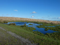
Spurrells Ancient Pool
OS Map: SX 65810 60059
HER record: MDV127224
ShortName: PO:Spurrells
Notes: "A pool measuring around 18m. One of over 40 such 'sacred' pools identified on Dartmoor that are thought to have potentially been designed during the prehistoric period. Lies to the north of a stone row. Livestock watering pond modified by peat cutting of 25 metres by 16 metres and 0.4 metres deep. The edges show the remains of peat cutting"
Nearby sites: SX65816006
Hickley Ridge E Cist
OS Map: SX 67402 62381
HER record: MDV61773
Megalithic Portal: 45811
PMD: Hickley Ridge E.
Alternate name: Hickley Ridge 1 Cist
ShortName: CT HickleyE
Butler map: 56.14.2
Butler Vol 5: p.175 & Fig.116
DPD page: 84
Notes: Butler Hickley Ridge Cist 1. 56.14.3 diagram Vol 5 p.175. "One side and one end slab of cist on Hickley Ridge, with other fallen stones in the mound. One of three badly damaged cists aligned south-west to north-east across Hickley Ridge, recognised by Butler in 1995." Lethbridge diagram and photo on right of p.84.
Nearby sites: SX67406238
Hickley Ridge Central Cist
OS Map: SX 67224 62250
HER record: MDV61772
Megalithic Portal: 45810
PMD: Hickley Ridge Central
Alternate name: Hickley Ridge 2 Cist
ShortName: CT HickleyCe
Butler map: 56.14.3
Butler Vol 5: p.175 & Fig.117
DPD page: 84
Notes: Butler Hickley Ridge Cairn and Cist 2. 56.14.3 diagram Vol 5 p.175. "Two slabs, possibly of a cist, embedded in low mound south of the leat on Hickley Ridge." Lethbridge diagram p.84, photo bottom left.
Nearby sites: SX67226225
Hickley Ridge W Cist
OS Map: SX 66590 62030
HER record: MDV13283
Megalithic Portal: 45809
PMD: Hickley Ridge W.
Alternate name: Hickley Ridge 3 Cist
ShortName: CT:HickleyW
Butler map: 56.14.4
Butler Vol 5: p.176 & Fig.118
DPD page: 84
Notes: "Cairn and cist on the East side of Brent Fore Hill. The cairn is 6.0m in diameter, merging into the slope of the hill and being about 0.5m high on the downslope side, which has a retaining kerb. There is a central cist of which two parallel slabs remain set on edge at the NW and SE sides. An upright stone 0.9m high is offset from the cist on the NW side." Lethbridge p.84 diagram and photo top left. Butler Hickley Ridge 3 56.14.4 diagram Vol 5 p.176.
Nearby sites: SX66596203
Old Hill Cairn
OS Map: SX 66344 62998
HER record: MDV13278
ShortName: CN:Old Hill
Butler map: 57.30
Grinsell: BRE 10
Nearby sites: SX66346300
Corringdon Cairn
OS Map: SX 66660 61200
HER record: MDV129966
ShortName: CN:Corringdon1
Notes: HER: One of two turf-covered cairns lying north-east of the Corringdon stone rows. One measures 7.4m. in diameter and 0.4m high. The other is 8.0m. by 6.5m. and 0.3m high. The re-survey of these cairns in 1979 showed that they are of an unusual class of monument, consisting mainly of multiple concentric stone rings. Additionally, there is a turf covered barrow to the North East of the cairns and a very large ruined monument, 23.0 m in diameter, comprising 5 or 6 multiple concentric stone rings lying between the cairns. The whole group is regarded as a ritual complex, possibly associated with the stone row.
Nearby sites: SX66666120
Corringdon Cairn
OS Map: SX 66650 61200
HER record: MDV129969
ShortName: CN:Corringdon2
Notes: HER: One of two turf-covered cairns lying north-east of the Corringdon stone rows. One measures 7.4m. in diameter and 0.4m high. The other is 8.0m. by 6.5m. and 0.3m high. The re-survey of these cairns in 1979 showed that they are of an unusual class of monument, consisting mainly of multiple concentric stone rings. Additionally, there is a turf covered barrow to the North East of the cairns and a very large ruined monument, 23.0 m in diameter, comprising 5 or 6 multiple concentric stone rings lying between the cairns. The whole group is regarded as a ritual complex, possibly associated with the stone row.
Nearby sites: SX66656120
Corringdon Ball B Reported Stone Row
OS Map: SX 66500 61100
HER record: MDV14802
The Stone Rows of GB: Corringdon Ball South
PMD: Corringdon Ball B Stone Row
ShortName: SR:CorringdonB
Notes: Group B consists of at least three multiple stone rows, parallel to Row A. The 1990 resurvey of the site showed this group of rows actually extends as far as Row A - nearly 200 metres and (along with C - see MDV5658), may in fact be a group of seven approximately parallel rows. Location of polygon is approximate.
Nearby sites: SX66506110
Corringdon Ball C Reported Stone Row
OS Map: SX 66500 61100
HER record: MDV5658
The Stone Rows of GB: Corringdon Ball South
PMD: Corringdon Ball C Stone Row
ShortName: SR:CorringdonC
Notes: HER: Group C consists of at least three multiple stone rows, parallel to to rows in Group B. The 1990 resurvey of the site showed this group of rows extends roughly as far as Row A and Group B - nearly 200 metres. Along with B - see MDV14802), may in fact be a group of seven approximately parallel rows set south-east of the single row A. Location of polygon is approximate.
Nearby sites: SX66506110
Ugborough Reported Cairn
OS Map: SX 65500 60900
HER record: MDV25681
ShortName: CN:Ugborough
Notes: HER: Spoil heap associated with Redlake tramway, Ugborough
Nearby sites: SX65506090
Piles Hill Cairn
OS Map: SX 65400 60500
HER record: MDV132368
ShortName: MDV132368
Notes: HER: Small cairn in Butterdon Hill to Piles Hill stone row. Turf-covered stony mound of 4 metres by 3 metres and 0.4 metres high. It marks the change of orientation at the north end of the row
Nearby sites: SX65406050
Page last updated 10/12/24