
Guide to the Monuments on Brent Moor and Dean Moor
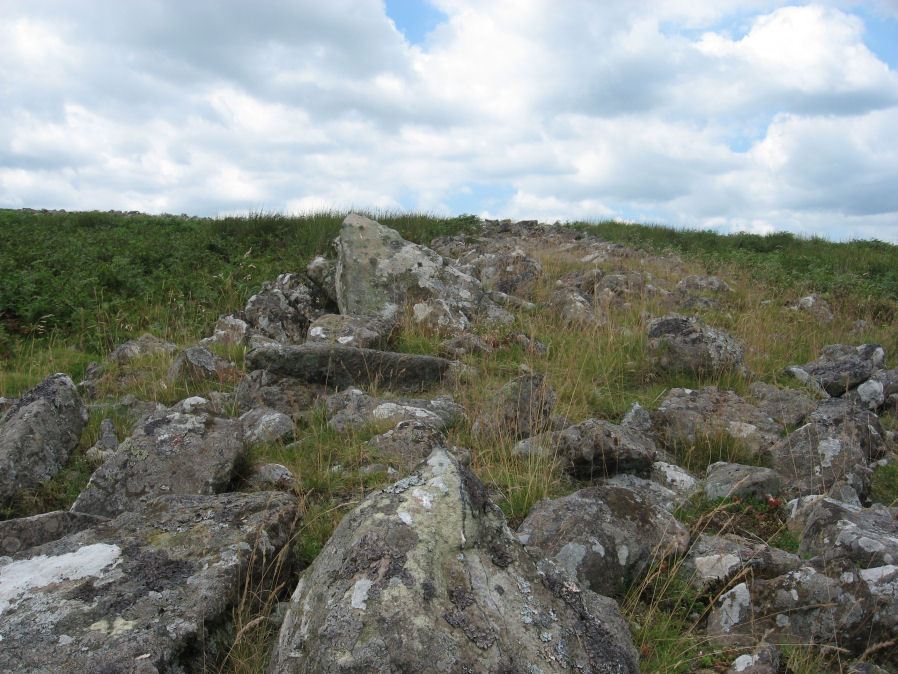
Table of Ritual and Burial Monuments on Brent Moor and Dean Moor
The following table lists the records currently in this Guide Map. For an explantion of the Guide Maps and a table of all 62 Guide Maps, follow this link: Guide List Table. Introductory text will be added to each guide list in 2025. Notes on duplication and omissions will appear below the table once checks have been finalised.
Notes on possible duplications and omissions
Hart Tor (Duplicate) Reported Stone Row. The HER record confuses Black Tor, South Brent for Black Tor as in the Hart Tor rows. This being a reference to "Black Tor" in Barrow Report 4 referring to Rowe, see p.190 in Third edition.PS. These notes are to assist untangling complicated records and are neither permanent nor a criticism of the HER who do a fantastic job! The author finds it easier to systematically work through these records (2000+ of them) and add these notes, which are then to be communicated with the HER, if appropriate, it is a pragmatic way of dealing with lots of data without continually stopping and starting.
Brent Moor and Dean Moor Guide Map
Guidance for walkers: The monuments featured in this database are archaeological treasures and need to be protected and preserved - please do not disturb any sites. Please check access and firing times before visiting sites, not all sites listed are on open access land. Firing ranges and boundaries of open access areas are marked on the OL28 OS Dartmoor Explorer map. Please stick to the country code and consider giving support to the numerous agencies that help to keep Dartmoor a fabulous natural and historic environment!
List of Ritual and Burial Monuments on Brent Moor and Dean Moor
Dockwell Ridge W. Cairn
OS Map: SX 68302 63962
HER record: MDV5745
ShortName: CN:Dockwell 1
Butler map: 57.9.1
Grinsell: BRE 4
Nearby sites: SX68306396
Dockwell Ridge N. Cairn
OS Map: SX 68695 64374
HER record: MDV13285
ShortName: CN:Dockwell 2
Butler map: 57.9.2
Nearby sites: SX68706437
Dockwell Ridge E.1 Cairn
OS Map: SX 69300 63730
HER record: MDV13287
ShortName: CN:Dockwell 3
Nearby sites: SX69306373
Dockwell Ridge E.2 Cairn
OS Map: SX 69350 63690
HER record: MDV13288
ShortName: CN:Dockwell 4
Notes: cairn on the open moor close to the dockwell moor gate. It lies about 15m from the corner of the moor wall on the west side of the funnel shaped approach to moor gate.
Nearby sites: SX69356369
Smallbrook Plains Cairn
OS Map: SX 68280 65040
HER record: MDV13202
ShortName: CN:Smallbrook
Butler map: 57.15
Grinsell: DEA 6
Nearby sites: SX68286504
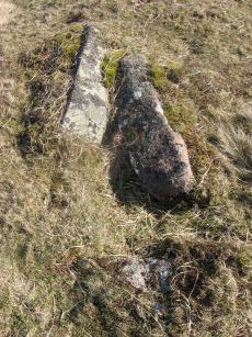
Brockhill Ford Ring Setting Cairn and Cist
OS Map: SX 67809 65702
HER record: MDV5234
Megalithic Portal: 705
PMD: Brockhill Ford
Alternate name: Brockhill Ford W. Ring Setting Cairn and Cist
ShortName: CT Brockhill
Butler map: 57.18
DPD page: 88
Grinsell: DEA 2
Turner: D3
Barrow Report: 68
Notes: "The side stones, both 1.4m long, lean inwards and the end stones north west 0.7m long, southeast 0.8m long, are firmly set. The probable coverstone, 1.2m by 0.8m, is displaced and lies to the south east of the cist. The cist is surrounded by the remains of a stone circle, long axis 8.8m, aligned with cist, short axis 7.2m. It is constructed of large slabs, up to 1.4m long with a single upright stone, 0.5m high, set contiguously in the north west arc. There are no visible remains of a cairn." Lethbridge p.88 photo (note the diagram is not related). See also: Huntingdon cross walk. Butler Brockhill Ford W. - Vol. 4. Map 57.18 (pp.151-2 diagram p.152).
Nearby sites: SX67816570
Brockhill Settlement
OS Map: SX 67700 65700
HER record: MDV5233
Megalithic Portal: 42627
ShortName: ST:Brockhill
Nearby sites: SX67706570
Dean Moor Enclosed Settlement
OS Map: SX 67741 65458
HER record: MDV14799
Megalithic Portal: 45324
ShortName: ES Dean Moor
Notes: Enclosed settlement on Dean Moor, excavated between 1954 and 1956, prior to construction of the reservoir. Prehistoric walled enclosure containing at least 13 huts together with pens. Parallels have been drawn with the settlement at Kestor. Part of the prehistoric settlement was incorporated into a medieval farmstead (see HER record 14221). Part of site now flooded by Avon Reservoir.
Nearby sites: SX67746546
Hickaton Hill Reported Cairn
OS Map: SX 67390 66162
HER record: MDV102675
ShortName: CN:Hickaton
Nearby sites: SX67396616
Buckland Ford Cairn Circle
OS Map: SX 65740 66040
HER record: MDV5187
Megalithic Portal: 717
ShortName: CC:Buckland Fd
Butler map: 57.23
DPD page: 87
Grinsell: LYD 107
Turner: G19
Barrow Report: 65
Notes: Probable cairn circle. "A small, probably sepulchral, stone circle. It consists of 14 stones arranged in an 'egg' shape. The long axis is 9.9 metres aligned due east by 8.2m transversely. A further 7 stones are in close proximity but may not be associated. There is no trace of a cist or cairn." "It is largely obscured by long tussocky grass and the absence of a discernible cairn or cist makes it an unusual site by Dartmoor standards".
Nearby sites: SX65746604
Black Tor (Avon) Stone Row
OS Map: SX 67730 63494
HER record: MDV28589
Megalithic Portal: 1772
The Stone Rows of GB: Black Tor Avon Stone Row
PMD: Black Tor Avon Stone Row
ShortName: SR BlackTor 1
Butler map: 57.25
DPD page: 85
Notes: "A stone row running north west - south east seen on the plateau west of Black Tor". The stones are very hidden and difficult to see. The row is headed at the NW end by two small cairns. Lethbridge suggests remains of cist in one of them, diagram p.85. See also HER 5752, SX 66 SE 89 and SX 66 SE 33. NB. There is also a possible second row about 200 metres away SiteID=1320
Nearby sites: SX67736349
Black Tor (Avon) 2 Stone Row
OS Map: SX 67500 63500
HER record: MDV5752
The Stone Rows of GB: Black Tor Avon Stone Row
PMD: Black Tor Avon Stone Row
ShortName: SR:BlackTor 2
Butler map: 57.25
Notes: HER: A stone row is alleged at this location by Worth (1932-33) but has not been located since, either by Worth, or during field investigation.. Masson Phillips: In August 1932 author was present at a field meeting led by R.H. Worth who pointed out a single stone row, more or less east to west with a low barrow at each end, he had discovered near the summit of Black Tor in the Avon Valley. Worth later contacted Quinnell to say he had been unable to locate it on a second visit. Quinnell also failed to locate it again, despite searching on at least six occasions 'had it not been that I and some 20 persons saw it in 1932 I would doubt its existence'. See also: HER MDV28589
Nearby sites: SX67506350
Black Tor (Avon) stone row Cairn
OS Map: SX 67749 63470
HER record: MDV5778
ShortName: CN BlackTorSR
Butler map: 57.25.1
Grinsell: BRE 5
Notes: The Black Tor (Avon) row is headed at the NW end by two small cairns. Lethbridge suggests remains of cist in one of them. Lethbridge Discover Prehistoric Dartmoor diagram p.85. [Photo and grid reference added in June 2019 from old data - it is probably right but could do with confirming].
Nearby sites: SX67756347
Black Tor (Avon) 2 Cairn
OS Map: SX 67720 63460
HER record: MDV129982
ShortName: CN:BlackTorAv2
Butler map: 57.25.2
Grinsell: BRE 5a
Nearby sites: SX67726346
Zeal Hill S.E.1 Reported Cairn
OS Map: SX 67570 63590
HER record: MDV129983
ShortName: CN?Zeal Hill 1
Butler map: 57.25.1
Notes: Butler "Two more cairns of small stone are ... 200 m directly uphill [from the Black Tor (Avon) stone row]. The smallest appears to be undmaged but its oval shaped neighbour has been dug into from one side".
Nearby sites: SX67576359
Zeal Hill S.E.2 Reported Cairn
OS Map: SX 67540 63600
HER record: MDV129984
ShortName: CN?Zeal Hill 2
Butler map: 57.25.2
Notes: Butler "Two more cairns of small stone are ... 200 m directly uphill [from the Black Tor (Avon) stone row]. The smallest appears to be undmaged but its oval shaped neighbour has been dug into from one side".
Nearby sites: SX67546360

Riders Rings Enclosed Settlement
OS Map: SX 67870 64359
HER record: MDV5767
Megalithic Portal: 45321
ShortName: ES RidersRings
DPD page: 85
Notes: "The largest and most important pound in the Avon Valley. Situated on the eastern slope of Zeal Plains. It is best regarded as being two contiguous pounds, of which it would appear that the south west member was constructed first, while the north east member was added as a later extension. The two pounds together cover an area of over six acres and enclose some three dozen hut-circles". Lethbridge p.85
Nearby sites: SX67876436
Eastern White Barrow (The Submarine) Cairn
OS Map: SX 66550 65168
HER record: MDV5184
Megalithic Portal: 45572
Alternate name: Eastern White Barrow Cairn
ShortName: CN:E White Bar
Butler map: 57.27
DPD page: 86
Grinsell: BRE 1
Notes: Also known as the Eastern Whittabarrow or Whittaburrow. "A large, round, flat topped cairn measuring 26m in diameter and 3.5m high. It is surmounted by a modern, drum-shaped, marker cairn of 4.5m diameter and 2m high. Known as The Submarine due to its appearance in profile on the horizon. See also Legendary Dartmoor: The Submarine
Nearby sites: SX66556517
Western White Barrow Cairn
OS Map: SX 65363 65487
HER record: MDV5193
Megalithic Portal: 28710
ShortName: CN:W White Bar
Butler map: 57.28
DPD page: 86
Grinsell: LYD 104
Notes: Western Whittabarrow or Whittaburrow. "A large cairn measuring 21 by 17.5 metres wide with a maximum height of 1.7 metres. It has been badly mutilated by the construction of a two room building within it."
Nearby sites: SX65366549
Western White Barrow (SE of) Stone Ring Cairn Circle
OS Map: SX 65530 65240
HER record: MDV39431
ShortName: RC:SE Western
Notes: NGR estimated from 6-digit figure given in HER. HER Circular ring of small stones measuring between 21-22 metres in diameter with a possible entrance. Located approximately 250 metres south-east from the Western White Barrow.
Nearby sites: SX65536524
Red Lake (near) Reported Cairn
OS Map: SX 65080 66170
HER record: MDV5194
ShortName: CNxRed Lake
Notes: A cairn was alleged at this location but could not be found. The site lies in an area of peat cutting.
Nearby sites: SX65086617
Knatta Barrow Stone Ring Cairn Circle
OS Map: SX 65970 64212
HER record: MDV5717
Megalithic Portal: 45842
ShortName: RC:Knatta Bar
Butler map: 57.29
Butler Vol 5: p.160 & Fig.102
Grinsell: BRE 2
Turner: A54
Notes: "This large cairn (24m diameter, 1.7m height) composed of loose granite boulders. It is unusual among summit cairns in having a well defined outer bank about 1m wide and 0.5m high. This is partly turf covered but where eroded can be seen to be built of loose stone like the central cairn which touches it. It shows best on the north and east sides, while on the south west side it tends to merge into the body of the cairn."
Nearby sites: SX65976421
Brent Moor House Cist
OS Map: SX 68020 64030
HER record: MDV5744
Megalithic Portal: 45754
PMD: Brent Moor House
ShortName: CT:Brent Moor
Grinsell: BRE 3
Barrow Report: 65 66
Notes: "A cist lies on the right bank of the Avon, a short distance above Brent Moor House, about 175 feet below the small stream which flows south of Riders Rings ... The cist, which consists of two end stones and one side stone, stands in a small cairn." Doubtful. (grinsell) "supposed cairn of large stones, enclosing possible cist placed se-nw. The whole area is covered with clitter, and it is possible that the site may be natural. In summer it is under dense bracken. No measurements given." Butler Vol. 4. Map 57.9 (not actually covered in Butler but relevant map). " A Medieval or later tinner's cache situated opposite Woolholes on the west bank of the River Avon. Considered under the Monument Protection Programme by previous Monument Protection Programme Advisor who did not recommend it for scheduling."
Nearby sites: SX68026403
Gripper's Hill W. Cairn
OS Map: SX 68118 65486
HER record: MDV130228
Alternate name: Gripper's Hill W. Cairn
ShortName: CN:Grippers W
Butler map: 57.31
Notes: Butler: sited in full view of the reservoir. Butler gives OS as SX 6810 6547. Near to this there is a mound visible in Google Earth at SX 68118 65486 - presumably it is this cairn.
Nearby sites: SX68126549
Gripper's Hill Stone Ring Cairn Circle
OS Map: SX 68650 65503
HER record: MDV5224
Megalithic Portal: 45822
Alternate name: Gripper's Hill Summit 1 Stone Ring Cairn Circle
ShortName: RC Grippers 1
Butler map: 57.31.1
Grinsell: DEA 4
Turner: A9
Notes: "Ring cairn on Gripper's Hill; stone ring 14.0 metres in diameter internally, with bank 1.2 meters wide and 0.3 meters high." NMR A
Nearby sites: SX68656550
Gripper's Hill Summit 2 Cairn
OS Map: SX 68592 65501
HER record: MDV5225
Alternate name: Gripper's Hill Summit 2 Cairn
ShortName: CN:Grippers 2
Butler map: 57.31.2
Grinsell: DEA 3
Notes: NMR B
Nearby sites: SX68596550
Gripper's Hill Summit 3 Reported Cairn
OS Map: SX 68380 65510
HER record: MDV130230
Alternate name: Gripper's Hill Summit 3 Reported Cairn
ShortName: CN:Grippers 3
Butler map: 57.31.3
Notes: Butler: "the more conspicuous [of the cairns] has been trenched".
Nearby sites: SX68386551
Gripper's Hill Summit 4 Reported Cairn
OS Map: SX 68370 65520
HER record: MDV130232
Alternate name: Gripper's Hill Summit 4 Reported Cairn
ShortName: CN:Grippers 4
Butler map: 57.31.4
Notes: Butler: not trenched, "retains an even profile and seems to have been overlooked by the cairn diggers".
Nearby sites: SX68376552
Gripper's Hill Summit E. Cairn
OS Map: SX 68893 65580
HER record: MDV5305
Alternate name: Gripper's Hill Summit E. Cairn
ShortName: CN:Grippers 5
Butler map: 57.31.5
Grinsell: DEA 4b
Nearby sites: SX68896558
Gripper's Hill N.1 Reported Cairn
OS Map: SX 68300 66390
HER record: MDV130233
Alternate name: Gripper's Hill N.1 Reported Cairn
ShortName: CN:GrippersN1
Butler map: 57.32.1
Notes: Butler. The reave "passes above an apparently undamaged cairn near the northern tip of the hill".
Nearby sites: SX68306639
Gripper's Hill N.2 Reported Cairn
OS Map: SX 68380 66190
HER record: MDV5302
Alternate name: Gripper's Hill N.2 Reported Cairn
ShortName: CN:GrippersN2
Butler map: 57.32.2
Nearby sites: SX68386619
Gripper's Hill (NW spur) Reported Cairn
OS Map: SX 68300 66000
HER record: MDV21710
Alternate name: Gripper's Hill (NW spur) Reported Cairn
ShortName: CN?GrippersN3
Grinsell: DEA 4a
Notes: A cairn was alleged at this location but there does not now appear to be any physical evidence. HER 21740 is based on this recod but gives NMR as SX 683 680. The record originates with Grinsel who gives SX 683 660 "roughly" - which is 2km south!
Nearby sites: SX68306600
Gripper's Hill SE Reported Cairn
OS Map: SX 69180 64970
HER record: MDV48859
Alternate name: Gripper's Hill SE Reported Cairn
ShortName: CN?GrippersSE
Grinsell: DEA 9
Notes: Grinsell's small cairn at SX 69126501, is no longer recognisable as such, appearing as a pit with a rim of upcast.
Nearby sites: SX69186497
Gripper's Hill Enclosed Settlement
OS Map: SX 68156 64874
HER record: MDV5742
Megalithic Portal: 45320
Alternate name: Gripper's Hill Enclosed Settlement
ShortName: ES Grippers
Notes: "A Bronze Age pastoral settlement on Gripper's Hill, Dean Prior, was excavated in July 1954 by Lady Aileen Fox on behalf of the Ministry of Works. The site comprises four enclosures containing ten or more huts."
Nearby sites: SX68166487
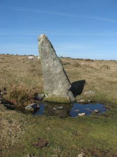
Harbourne Head Standing Stone
OS Map: SX 69676 65105
HER record: MDV5197
Megalithic Portal: 42626
PMD: Harbourne Man Standing Stone
Alternate name: Harbourne Man Standing Stone
ShortName: SS Harbourne
Butler Vol 5: p.19
DPD page: 88
Notes: A standing stone represented by a leaning slab of moorland granite. It stands in a slight depression probably worn by cattle using it as a rubbing post. It is 2.40m in length and 1.0m by 0.3m at its base tapering to 0.3m by 0.15m. See also, Legendary Dartmoor: Dartmoor's Harbourne Man
Nearby sites: SX69686511
Harbourne Head Reported Cairn
OS Map: SX 69460 65350
HER record: MDV21709
ShortName: CN?Harbourne 1
Nearby sites: SX69466535
Harbourne Head, NE of Cairn
OS Map: SX 69767 65582
HER record: MDV5298
ShortName: CN:Harbourne 2
Grinsell: DEA 12
Notes: A cairn sited on hill slope on arable land crowned by a stoneheap.
Nearby sites: SX69776558
Harbourne Head A Stone Ring Cairn Circle
OS Map: SX 69119 65039
HER record: MDV5802
Megalithic Portal: 42628
Alternate name: Parnell's Hill 1 Stone Ring Cairn Circle
ShortName: RC Harbourne A
Butler map: 57.31.6
Grinsell: DEA 8
Turner: A55
Notes: "One of a pair of cairns on Gripper's Hill." " A ring cairn, Harbourne Head consisting of a stone ring 17.0 metres in diameter internally, with bank 1.8 metres wide and 0.4 metres high. Cairn contains a central mound, 12.0 metres in diameter, 0.8 metres high. This type of cairn is referred to as a Dartmoor version of the Wessex bell barrows."
Nearby sites: SX69126504
Harbourne Head B Embanked Cairn Circle
OS Map: SX 69147 65009
HER record: MDV5803
Megalithic Portal: 3279
Alternate name: Parnell's Hill 2 Embanked Cairn Circle
ShortName: CC Harbourne B
Butler map: 57.31.7
Grinsell: DEA 10
Turner: B12
Notes: "Embanked stone circle; annular bank of earth and/or stones with inner kerb of orthostats. Measures 15.0 metres in diameter internally with bank 2.0 metres wide and 0.5 meters high with a cairn in the centre, 9.0 metres in diameter and 1.1 metres in height. The west and south sides have been disturbed."
Nearby sites: SX69156501
Lambs Down 1 Clearance Cairn
OS Map: SX 69730 66070
HER record: MDV130234
ShortName: CN?LambsDown 1
Butler map: 57.33.1
Notes: Butler refers to burial cairns amongst clearance cairns.
Nearby sites: SX69736607
Lambs Down 2 Clearance Cairn
OS Map: SX 69452 65895
HER record: MDV5196
ShortName: CN:LambsDown 2
Butler map: 57.33.2
Notes: Butler refers to burial cairns amongst clearance cairns.
Nearby sites: SX69456590
Lambs Down 3 Clearance Cairn
OS Map: SX 69460 65850
HER record: MDV130235
ShortName: CN:LambsDown 3
Butler map: 57.33.3
Notes: Butler refers to burial cairns amongst clearance cairns.
Nearby sites: SX69466585
Lambs Down 4 Clearance Cairn
OS Map: SX 69512 65809
HER record: MDV13199
ShortName: CN:LambsDown 4
Nearby sites: SX69516581
Lambs Down 5 Reported Cairn
OS Map: SX 68920 66050
HER record: MDV20904
ShortName: CN?LambsDown 5
Nearby sites: SX68926605
Lambs Down 6 Cairnfield Master
OS Map: SX 69850 65650
HER record: MDV5299
ShortName: CN?LambsDown 6
Notes: HER: "A series of mounds which may be the result of modern field clearance, or they possibly be the remains of prehistoric cairns. Four of the larger mounds may have entrances and average 8.7 metres in diameter and 0.6 metres in height."
Nearby sites: SX69856565
Skerraton Gate E.1 Cairn
OS Map: SX 70211 64979
HER record: MDV7949
ShortName: CN:SkerrGate 1
Butler map: 57.34
Butler Vol 5: p.17 & Fig.1
Grinsell: DEA 13e
Notes: 444974/1572758/1572754
Nearby sites: SX70216498
Skerraton Gate E.2 Cairn
OS Map: SX 70240 64930
HER record: MDV7947
ShortName: CN:SkerrGate 2
Butler map: 57.34
Butler Vol 5: p.17 & Fig.1
Notes: The HER record for E.2 was added close to an existing HEr record. The two grid references are just 20-30 metres apart and that would in most circumstances result in this being a case of duplication. However, Fig 1 on p.17 of Butlre Volume 5 cleary has two cairns very close together in this location. It maybe a happy accident that there are two records. The western of the two features (this one) is the larger and as such is probably the one Butler intended as E.2. This record realtes to the smaller eastern cairn. See also [https://www.dartmoorwalks.org.uk/resource/site.php?SiteID=1799]Skerraton Gate E.6[/url]
Nearby sites: SX70246493
Skerraton Gate E.3 Cairn
OS Map: SX 70269 64948
HER record: MDV7946
ShortName: CN:SkerrGate 3
Butler map: 57.34
Butler Vol 5: p.17 & Fig.1
Grinsell: DEA 13g
Nearby sites: SX70276495
Skerraton Gate E.4 Cairn
OS Map: SX 70270 65017
HER record: MDV7829
ShortName: CN:SkerrGate 4
Butler map: 57.34
Butler Vol 5: p.17 & Fig.1
Grinsell: DEA 13h
Nearby sites: SX70276502
Skerraton Gate E.5 Reported Cairn
OS Map: SX 70230 64962
HER record: MDV7948
ShortName: CN:SkerrGate 5
Butler Vol 5: p.17 & Fig.1
Grinsell: DEA 13i-m
Notes: DEA 13i-m. Mounds (c.5) - poss. clearance.Formerly listed has Skerraton Down DEA 13i-m. See Fig 1 p17 of Butler Volume 5 - there is a small cairn at this grid reference in the middle of the Skerraton Gate group.
Nearby sites: SX70236496
Skerraton Gate E.6 Cairn
OS Map: SX 70226 64917
HER record: MDV7950
ShortName: CN:SkerrGate 6
Butler map: 57.34
Butler Vol 5: p.17 & Fig.1
Grinsell: DEA 13f
Notes: This entry was formerly for Skerraton Gate E.2 but another HER record now relates to that. The two grid references are just 20-30 metres apart and that woudl in most circumstances result in this being a case of duplication. However, Fig 1 on p.17 of Butlre Volume 5 cleary has two cairns very close together in this location. It maybe a happy accident that there are two records. The western of the two features (this one) is the larger and as such is probably the one Butler intended as E.2. See also Skerraton Gate E.2
Nearby sites: SX70236492
Skerraton Gate S.W.1 Cairn
OS Map: SX 70008 64886
HER record: MDV28587
ShortName: CN:SkerGateSW1
Butler map: 57.34
Grinsell: DEA 7
Nearby sites: SX70016489
Skerraton Gate S.W.2 Reported Cairn
OS Map: SX 70060 64700
HER record: MDV7944
ShortName: CN?SkerGateSW2
Grinsell: DEA 14
Notes: Cairn or clearance heap. formerly listed as Skerraton Down (DEA 14).
Nearby sites: SX70066470
Skerraton Down 1 Reported Cairn
OS Map: SX 70070 65260
HER record: MDV7832
ShortName: CN?Skerraton 1
Butler map: 57.34
Butler Vol 5: p.17 & Fig.1
Grinsell: DEA 13a
Notes: "A circular mound about 5 metres in diameter and approximetly 1 metre high. Turf-covered and apparently undisturbed (4 metres from field boundary). Recorded in 1980s as reduced to ground level by agricultural operations." 444974/1572758/1572754
Nearby sites: SX70076526
Skerraton Down 2 Reported Cairn
OS Map: SX 70070 65240
HER record: MDV7831
ShortName: CN?Skerraton 2
Butler map: 57.34
Butler Vol 5: p.17 & Fig.1
Grinsell: DEA 13b
Notes: "A circular mound about 12 metres in diameter. Composed of small stones and hollow in the centre (12 metres from the field boundary). Barrow recorded in 1980s as reduced to ground level by agricultural operations." 444974/1572758/1572754
Nearby sites: SX70076524
Skerraton Down 3 Clearance Cairn
OS Map: SX 70100 65220
HER record: MDV7830
ShortName: CN:Skerraton 3
Butler map: 57.34
Butler Vol 5: p.17 & Fig.1
Grinsell: DEA 13c
Turner: B4
Notes: 444974/1572758/1572754
Nearby sites: SX70106522
Skerraton Down 4 Clearance Cairn
OS Map: SX 70120 65200
HER record: MDV7828
ShortName: CN:Skerraton 4
Butler map: 57.34
Butler Vol 5: p.17 & Fig.1
Grinsell: DEA 13d
Notes: 444974/1572758/1572754
Nearby sites: SX70126520
Skerraton Ridge 1 Reported Cairn
OS Map: SX 69936 65357
HER record: MDV5297
ShortName: CN:SkerRidge 1
Butler map: 57.34.1
Butler Vol 5: p.17 & Fig.1
Grinsell: DEA 11
Notes: 444974/1572758/1572754
Nearby sites: SX69946536
Skerraton Ridge 2 Cairn
OS Map: SX 69980 65310
HER record: MDV130243
ShortName: CN:SkerRidge 2
Butler map: 57.34.2
Butler Vol 5: p.17 & Fig.1
Grinsell: DEA 5a
Turner: A29
Notes: The following are thought to be the same: Grinsell DEA 5a SX69996530 (6 x 0.15) and Turner A29 70066529. It would seem both the the NMR and HER have treated these as two separate cairns - this can be seen from the grid referencs in the two NMR records and both HER records refer to Turner A29. NMR 444856 is thus a duplicate of 441549. HER 48850 is thus a duplicate of of HER 7833.
Nearby sites: SX69986531
Skerraton Ridge 3 Reported Cairn
OS Map: SX 70000 65300
HER record: MDV130244
ShortName: CN?SkerRidge 3
Butler map: 57.34.3
Butler Vol 5: p.17 & Fig.1
Grinsell: DEA 5
Notes: "A circular mound about 7 metres in diameter and approximately 1 metre high. Turf covered, possibly undisturbed. Recorded in 1980s as destroyed by agricultural operations."
Nearby sites: SX70006530
Skerraton Ridge 2 (duplicate 1) Cairn
OS Map: SX 69980 65310
HER record: MDV7833
ShortName: CN:SkRgeDup1
Butler map: 57.34.2
Butler Vol 5: p.17 & Fig.1
Grinsell: DEA 5a
Turner: A29
Notes: The following are thought to be the same: Grinsell DEA 5a SX69996530 (6 x 0.15) and Turner A29 70066529. It would seem both the the NMR and HER have treated these as two separate cairns - this can be seen from the grid referencs in the two NMR records and both HER records refer to Turner A29. NMR 444856 is thus a duplicate of 441549. HER 48850 is thus a duplicate of of HER 7833.
Nearby sites: SX69986531
Skerraton Ridge 2 (duplicate 2) Reported Cairn
OS Map: SX 70060 65290
HER record: MDV48850
ShortName: CN:SkRgeDup2
Notes: Duplicate! The following are thought to be the same: Grinsell DEA 5a SX69996530 (6 x 0.15) and Turner A29 70066529. It would seem boththe the NMR and HER havetreated these as two separate cairns - this can be seen from the grid referencs int eh two NMR reords and both HER records refer to Turner A29. NMR 444856 is thus a duplicate of 441549. HER 48850 is thus a duplicate of of HER.
Nearby sites: SX70066529
Huntingdon Warren 1 Reported Cairn
OS Map: SX 65860 66350
HER record: MDV129189
ShortName: CNxHuntingdo1
Butler map: 58.1.1
Notes: Hut circle or pillow mound?
Nearby sites: SX65866635
Huntingdon Warren 2 Reported Cairn
OS Map: SX 66060 66350
HER record: MDV129203
ShortName: CNxHuntingdo2
Butler map: 58.1.2
Notes: Hut circle or pillow mound?
Nearby sites: SX66066635
Tynacombe Stone Ring Cairn Circle
OS Map: SX 70370 63280
HER record: MDV13638
Megalithic Portal: 45832
ShortName: RC:Tynacombe
Turner: A20
Notes: "Ring cairn. Thynacombe stone ring 7.5 meters in diameter internally, with bank 1.5 meters wide and 0.2 meters high, damaged on the east side."
Nearby sites: SX70376328
Tynacombe 2 Clearance Cairn
OS Map: SX 70300 63300
HER record: MDV13636
Megalithic Portal: 45832
ShortName: CN:Tynacombe2
Notes: HER: Remains of barrow. Thinacombes. Possible field clearance cairn. Vis=-/5/1968? (robinson, r. ). A long narrow heap of stones, partly turfed over in the nw corner of field os no 1863, tithe apportionment no.206(1843) 'cold east field'. It measures 16m x 4m lying roughly e-w with the w end about 26m from the west field boundary. It has well defined edge to the s giving a height of about 0.5m but on the n or uphill side it merges into the slope. This may well represent field clearance. There is another possible ring cairn in the same field. The area is slate and the stones comprising the heap, where visible are small pieces of slate. This has been inspected by mr. T. Greeves who considered the site a very doubtful barrow or the result of field clearance. Vis=not visible on raf 1948 aph (rchm aph 1985).
Nearby sites: SX70306330
Tynacombe 3 Cairn
OS Map: SX 70400 63400
HER record: MDV13637
ShortName: CN:Tynacombe3
Notes: HER: A low grass-covered mound in the north-west corner of a field, which measures around 0.5 metres in height and 10 metres in diameter, with no stones visible. The edge is most clearly defined on the downhill side tending to merge into the natural hillside on the upper side.
Nearby sites: SX70406340
Hart Tor (Duplicate) Reported Stone Row
OS Map: SX 68000 63000
HER record: MDV132249
ShortName: SRxHart_Dup
Notes: This HER record has confused Black Tor, South Brent with Black Tor near Hart Tor. The description is of the Hart Tor stone rows. See p.190 of Third Edition of Rowe, the narrative is about the Devonport Leat and the Crazywell pool before moving on to the rows at Black Tor i.e. the Hart Tor rows. HER: A stone row was alleged at Black Tor (1882) but there was no trace of the monument during field investigation (1950). 4th barrow Report:STONE ROW, BLACK TOR: Nearly a furlong from the Tor in the glen below, on the eastern bank of the stream, are a pair of avenues which are only 40 feet apart and run parallel to each other east and west. They are formed of stones 2.5 feet high and each is terminated at the eastern end by a circle 36 feet in diameter consisting, of 15 stones enclosing a cairn. Between the northern avenue and the stream is a cairn while another, very imperfect, will be observed at end of southern avenue (citing Row's Perambulation, Second Edition, pp.205-6).
Nearby sites: SX68006300
Page last updated 10/12/24