
Guide to the Monuments on Plym Steps and Langcombe Brook

Table of Ritual and Burial Monuments on Plym Steps and Langcombe Brook
The following table lists the records currently in this Guide Map. For an explantion of the Guide Maps and a table of all 62 Guide Maps, follow this link: Guide List Table. Introductory text will be added to each guide list in 2025. Notes on duplication and omissions will appear below the table once checks have been finalised.
Plym Steps and Langcombe Brook Guide Map
Guidance for walkers: The monuments featured in this database are archaeological treasures and need to be protected and preserved - please do not disturb any sites. Please check access and firing times before visiting sites, not all sites listed are on open access land. Firing ranges and boundaries of open access areas are marked on the OL28 OS Dartmoor Explorer map. Please stick to the country code and consider giving support to the numerous agencies that help to keep Dartmoor a fabulous natural and historic environment!
List of Ritual and Burial Monuments on Plym Steps and Langcombe Brook
Deadman's Bottom, South Ring Setting Cairn and Cist
OS Map: SX 60788 66892
HER record: MDV5119
Megalithic Portal: 3194
PMD: Deadman's Bottom N 2
Alternate name: Langcombe Brook 1 Ring Setting Cairn and Cist
ShortName: CT Deadmans S
Butler map: 50.3.1
DPD page: 45
Grinsell: SHA 8
Turner: D12
Barrow Report: 12 19
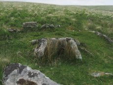
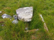
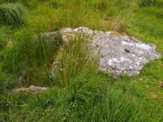
Notes: "Cairn consists of a stony mound, c 6.1m in diameter and c 0.5m high, contained by granite slabs some upright some fallen. The southern quadrant of the cairn has been disturbed. The remains of a very fine cist, box dimensions c. 0.8 x 0.7m internally, survives at its centre." One side slab and the cover-stone of the cist are missing although both could be slabs nearby. The cover-stone may be the large slab which lies to the south. Lethbridge p.45 Langcombe Cist D - diagram p.43 Dixon #7. Bar Rep. 19. Butler Langcombe Brook 1 (Cist 1) Vol. 3. Map 50.3 (pp.148-54 general plan of Langcombe Brook cairns p.151, diagram of Deadmans Bottom cists p.149).
Nearby sites: SX60796689
Deadman's Bottom, North Cist
OS Map: SX 60782 66900
HER record: MDV5120
Megalithic Portal: 3194
PMD: Deadman's Bottom N 1
Alternate name: Langcombe Brook 2 Cist
ShortName: CT Deadmans N
Butler map: 50.3.2
DPD page: 44
Grinsell: SHA 7
Barrow Report: 12 19
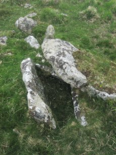
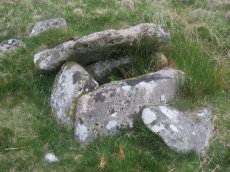
Notes: "The remains of a cist lie on the northern slopes of Deadmans Bottom. The feature consists of a stone lined box, c.1m long and c. 0.4m wide, with a coverstone which has now slid to the north. The cist has collapsed in on itself. There is a turf covered stone spread to the south but little real evidence of an associated cairn." Lethbridge p.44 Langcombe Cist C - diagram p.43 Butler Langcombe Brook 2 (Cist 2) - Vol. 3. Map 50.3 (pp.148-54 general plan of Langcombe Brook cairns p.151, diagram of Deadmans Bottom cists p.149).
Nearby sites: SX60786690
Grims Grave Ring Setting Cairn and Cist
OS Map: SX 61245 66422
HER record: MDV5083
Megalithic Portal: 14930
PMD: Grim's Grave
ShortName: CT Grims Grave
Butler map: 50.3.3
DPD page: 46
Grinsell: SHA 13
Turner: D20
Barrow Report: 12 20 56
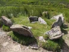
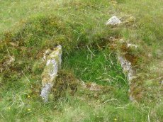
Notes: "A ring cairn set into the slope, c 4.5m in diameter, with a cist at its centre. The cairn consists of a stony, turf-covered mound contained by a ring of upright slabs, most leaning outwards, c 1m in height; the mound rises to c 0.4m at top of cist. The cist, box dimensions c 0.8m x 0.95m internally, is formed from edge-set slabs. One side slab is c 1.7m long, 0.9m wide and 0.2m thick. The monument survives in a very good condition though the cover-stone is missing - this is possibly the slab that now lies on the down-slope side."
Nearby sites: SX61256642
Grim's Grave (S) Platform Cairn Circle and Cist
OS Map: SX 61251 66313
HER record: MDV5126
Megalithic Portal: 14929
PMD: Langcombe Brook S.
Alternate name: Langcombe Brook 4 Platform Cairn Circle and Cist
ShortName: CT GrimsGraveS
Butler map: 50.3.4
Butler Vol 5: p.160
DPD page: 46
Grinsell: SHA 18
Turner: E8
Barrow Report: 50
Notes: Lethbridge p.46 Langcombe Cist H - diagram p.43. Butler Langcombe Brook 4 (Cairn 4) - Vol. 3. Map 50.3 (pp.148-54 general plan of Langcombe Brook cairns p.151, diagram of Langcombe cists p.153).
Nearby sites: SX61256631
Langcombe Brook 5 Cist
OS Map: SX 60878 66421
HER record: MDV5129
Megalithic Portal: 45767
PMD: Langcombe Brook 5
ShortName: CT:Langcombe 5
Butler map: 50.3.5
DPD page: 46
Grinsell: SHA 17
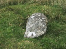
Notes: "Two end stones and two side stones are in position but the coverstone is missing. The tops of the stones are at ground level Length of N side stone 1.4m, S side stone 1m, W end stone 0.6m, and E end stone 0.5m. Present depth of cist is 0.3m." Lethbridge p.46 Langcombe Cist I - diagram p.43. Butler Langcombe Brook 5 (Cairn 5) - Vol. 3. Map 50.3 (pp.148-54 general plan of Langcombe Brook cairns p.151, diagram of Langcombe cists p.153).
Nearby sites: SX60886642
Langcombe (S) Platform Cairn Circle and Cist
OS Map: SX 60866 66155
HER record: MDV5128
Megalithic Portal: 45729
PMD: Langcombe Brook 6
Alternate name: Langcombe Brook 6 Platform Cairn Circle and Cist
ShortName: CT Langcombe 6
Butler map: 50.3.6
DPD page: 47
Grinsell: SHA 19
Turner: E23
Barrow Report: 50 52
Notes: "A cist, lying a little over 590 yds south west of Grim's Grave, within a flat topped cairn. Cist has two sides and the south end stone are in place and the cover stone rests in part over the cist". Lethbridge p.47 Langcombe Cist J - diagram p.43. Butler Langcombe Brook 6 (Cairn 6) - Vol. 3. Map 50.3 (pp.148-54 general plan of Langcombe Brook cairns p.151, diagram of Langcombe cists p.153).
Nearby sites: SX60876616
Langcombe Brook 7 Cist
OS Map: SX 60380 66921
HER record: MDV5134
Megalithic Portal: 45765
PMD: Langcombe Brook 7
ShortName: CT Langcombe 7
Butler map: 50.3.7
DPD page: 47
Grinsell: SHA 16
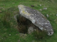
Notes: "Two end stones and the western side stone are in an upright position while the eastern side stone leans inwards. Length of northern end stone 0.7m, southern end stone 0.7m, eastern side stone 1.2m and western side stone 1m. Present depth of cist 0.3m. There is a cover stone measuring 1.6m by 1m which rests on the eastern side stone and which partly covers the northern corner of the cist". Lethbridge p.47 Langcombe Cist K - diagram p.43 Butler Langcombe Brook 7 (Cairn 7) - Vol. 3. Map 50.3 (pp.148-54 general plan of Langcombe Brook cairns p.151, diagram of Langcombe cists p.153).
Nearby sites: SX60386692
Plym Steps Ring Setting Cairn and Cist
OS Map: SX 60427 67110
HER record: MDV5133
Megalithic Portal: 45659
PMD: Langcombe Brook 8
Alternate name: Langcombe Brook 8 Ring Setting Cairn and Cist
ShortName: CT Plym Steps
Butler map: 50.3.8
DPD page: 44
Grinsell: SHA 4
Turner: D22
Barrow Report: 19
Notes: Central cist. Butler Langcombe Brook 8 (Cairn 8)- Vol. 3. Map 50.3 (pp.148-54 general plan of Langcombe Brook cairns p.151, diagram of Langcombe cists p.153). Lethbridge p.44 Langcombe Cist B - diagram p.43
Nearby sites: SX60436711
Deadmans Bottom E Cist
OS Map: SX 60984 66714
HER record: MDV5122
Megalithic Portal: 45732
PMD: Deadman's Bottom S 9
Alternate name: Langcombe Brook 9 Cist
ShortName: CT Deadmans E
Butler map: 50.3.9
DPD page: 45
Grinsell: SHA 11
Barrow Report: 53
Notes: "Cist (Listed as 'E' by Worth) found at Deadman's Bottom, Langcombe, by Mr. Button. Probable original dimensions, length 2ft 2 ins, width 1ft. 5ins. The stones barely show above the surface and the cover-stone is missing." ... "A well defined cairn 6.0m in diameter and 0.4m high with a cist in the top. This stone-lined cist measures 0.7m by 0.5m internally and 0.3 deep. Two of the side stones have fallen inwards." Lethbridge p.45 Langcombe Cist F - diagram p.43 Butler Langcombe Brook Cairn 9 - Vol. 3. Map 50.3 (pp.148-54 general plan of Langcombe Brook cairns p.151, diagram of Langcombe cists p.153).
Nearby sites: SX60986671
Deadmans Bottom D Platform Cairn Circle and Cist
OS Map: SX 60960 66730
HER record: MDV5086
Megalithic Portal: 45731
PMD: Deadman's Bottom S 10
Alternate name: Langcombe Brook 10 Platform Cairn Circle and Cist
ShortName: CT:Deadmans D
Butler map: 50.3.10
DPD page: 45
Grinsell: SHA 10
Turner: E44
Barrow Report: 53
Notes: "The cairn is 5m in diameter by 0.3m high with a retaining kerb on its northern side. The cist is 0.8m long b 0.7m wide." "Cist (listed as 'D' by Worth) found at Deadman's Bottom Langcombe, by Mr Button. Internal dimensions, length 3 feet 8 inches, width 2 feet. The stones are barely visible above grass level. The cover stone is missing." Lethbridge p.45 Langcombe Cist E - diagram p.43. Butler Langcombe Brook Cairn 10 - Vol. 3. Map 50.3 (pp.148-54 general plan of Langcombe Brook cairns p.151, diagram of Langcombe cists p.153).
Nearby sites: SX60966673
Deadmans Bottom F Platform Cairn Circle and Cist
OS Map: SX 61201 66983
HER record: MDV5125
Megalithic Portal: 45733
PMD: Deadman's Bottom E.
Alternate name: Langcombe Brook 11 Platform Cairn Circle and Cist
ShortName: CT Deadmans F
Butler map: 50.3.11
DPD page: 43
Grinsell: SHA 12
Barrow Report: 53
Notes: "Cist (Listed as 'F' by Worth) found at Deadman's Bottom, Langcombe, by Mr. Button. The cover-stone is still in position but the cist appears to have been rifled, the end and side-stones having been displaced at the north-east and southwest angles. Original length would appear to have been 2 feet 10 inches, and the width 1 foot 7 inches. The greatest length of the cover-stone is 4ft 9 inches and its greatest width 3 feet 1 1/2 inches." ... "A flat-topped cairn measuring 5.4m in diameter and standing a maximum of 0.4m high. A well-preserved cist 1.3m long, 0.6m wide and 0.15m deep is largely obscured by the coverstone". Lethbridge p.43 Langcombe Cist A (Upper Deadman's Bottom) - diagram p.43. nb. Not listed by Turner - assigned as "Platform Circle" type cairn due to description in NMR. Butler Langcombe Brook Cairn 11 - Vol. 3. Map 50.3 (pp.148-54 general plan of Langcombe Brook cairns p.151, diagram of Langcombe cists p.153).
Nearby sites: SX61206698
Langcombe Head 1 Reported Cairn
OS Map: SX 61990 66300
HER record: MDV13173
ShortName: CN?LangcomHead
Butler map: 50.3.12
Grinsell: COR 24
Notes: Probing confirms that the mound is a peat stack.
Nearby sites: SX61996630
Langcombe Head 2 Cairn
OS Map: SX 62040 66300
HER record: MDV13174
ShortName: CN:LangcomHd2
Nearby sites: SX62046630
Calveslake Cist
OS Map: SX 60874 67551
HER record: MDV5085
Megalithic Portal: 45660
PMD: Calveslake Tor
Alternate name: Calveslake Tor Cist
ShortName: CT Calveslak
Butler map: 50.4
DPD page: 43
Grinsell: SHA 3
Barrow Report: 12 19
Notes: "A perfect, well constructed cist at Calveslake. Length, 3ft 7inches; width at north end,1ft 7 1/2 inches; at south end, 1ft 9inches, depth to floor, 2ft 7inches. An irregular shaped cover-stone overhangs the eastern end of the cist. The barrow in which the cist stands has a diameter of 18 feet." Lethbridge Calves Lake cist p.42-43, diagram p.42. Butler Calveslake Tor - Vol. 3. Map 50.4 (diagram p.154).
Nearby sites: SX60876755
Deadman's Bottom Embanked Cairn Circle
OS Map: SX 60711 67027
HER record: MDV12420
Megalithic Portal: 3194
Alternate name: Deadman's Bottom 1 Embanked Cairn Circle
ShortName: CC Deadmans 1
Turner: B1
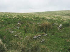
Notes: "Turner identifies this site as an embanked stone circle; an annular bank of earth and/or stones with an inner edge of orthostats. Internal diam 16m with bank 0.8m wide and 0.3m high. The bank has been pushed out on the sse side and the stones lean outward (turner)." Turner B1.
Nearby sites: SX60716703
Deadman's Bottom 2 Reported Cairn
OS Map: SX 60630 66830
HER record: MDV20163
Alternate name: Deadman's Bottom 2 Reported Cairn
ShortName: CN?Deadmans 2
Grinsell: SHA 9b
Notes: Hut circle or cairn?
Nearby sites: SX60636683
Deadman's Bottom 3 Reported Cairn
OS Map: SX 60590 66860
HER record: MDV5130
Alternate name: Deadman's Bottom 3 Reported Cairn
ShortName: CN?Deadmans 3
Grinsell: SHA 9a
Notes: Hut circle or cairn?
Nearby sites: SX60596686
Deadman's Bottom 4 Reported Cairn
OS Map: SX 60610 66840
HER record: MDV5131
Alternate name: Deadman's Bottom 4 Reported Cairn
ShortName: CN?Deadmans 4
Grinsell: SHA 9
Notes: Hut circle or cairn?
Nearby sites: SX60616684
Deadman's Bottom 5 (pos duplicate) Reported Cairn
OS Map: SX 60670 66960
HER record: MDV22795
Alternate name: Deadman's Bottom 5 (pos duplicate) Reported Cairn
ShortName: CN:Deadmans 5
Notes: UPDATE 31/12/2022. This record was duplicated by HER record MDV57442 which has now been deleted (SiteID=4270, also deleted)
Nearby sites: SX60676696
Deadman's Bottom 7 (pos duplicate) Reported Cairn
OS Map: SX 60710 66970
HER record: MDV57423
Alternate name: Deadman's Bottom 7 (pos duplicate) Reported Cairn
ShortName: CN:Deadmans 7
Nearby sites: SX60716697
Deadman's Bottom 8 (pos duplicate) Reported Cairn
OS Map: SX 60650 66910
HER record: MDV57434
Alternate name: Deadman's Bottom 8 (pos duplicate) Reported Cairn
ShortName: CN:Deadmans 8
Nearby sites: SX60656691
Deadman's Bottom 9 (pos duplicate) Reported Cairn
OS Map: SX 60650 66890
HER record: MDV57437
Alternate name: Deadman's Bottom 9 (pos duplicate) Reported Cairn
ShortName: CN:Deadmans 9
Nearby sites: SX60656689
Deadman's Bottom 10 (duplicate) Reported Cairn
OS Map: SX 60640 66830
HER record: MDV57440
Alternate name: Deadman's Bottom 10 (duplicate) Reported Cairn
ShortName: CN:Deadmans 10
Nearby sites: SX60646683
Deadman's Bottom (E) Cairn
OS Map: SX 60788 66893
HER record: MDV5118
Alternate name: Deadman's Bottom (E) Cairn
ShortName: CN Deadmans E
Butler map: 50.1
Grinsell: SHA 6
Turner: D28
Notes: Worth considered this to be a cairn. It was excavated and it was found to be paved with reddened earth showing great fires had been present. Butler Circle 1. Butler suggests it could just have been a hut circle and the fires the consequence of domestic activity. He points out the presence of a settlement wall. However it is also very close to a pair of cists and could be a cairn. We are listing as a cairn although Butler could of course be right. This "circle" can be clearly seen in the Google satellite images. Previously listed at SX 60798 66895 (Garmin reading?), presumed SX 60788 66893 from Google.
Nearby sites: SX60796689
Deadman's Bottom (W) Reported Cairn
OS Map: SX 60700 66970
HER record: MDV57422
Alternate name: Deadman's Bottom (W) Reported Cairn
ShortName: CN:Deadmans W
Butler map: 50.1
Grinsell: SHA 5
Turner: D27
Notes: Hut circle. Butler Circle 2 / 3
UPDATE 31/12/2022
The following 3 records have been merged into one with the first retained and the other two deleted, this corresponds with maintenance done on the HER (MDV48861 and MDV57422 have been deleted). The NGRs have been reset to match MDV57422.
1. SiteID=2587(was MDV48861) now set to HER=MDV57422
2. SiteID=4174 (was MDV57441) deleted
3. SiteID=4169 (was MDV57422) deleted
Nearby sites: SX60706697
Deadman's Bottom 13 Reported Cist
OS Map: SX 60800 66800
HER record: MDV5121
Alternate name: Deadman's Bottom 13 Reported Cist
ShortName: CT:Deadmans 13
Notes: Duplicate: Record gives an account of the Deadman's Bottom North and South cists and the associated circles.
Nearby sites: SX60806680
Lower Hartor Tor Cairn
OS Map: SX 60174 67299
HER record: MDV5082
ShortName: CN:LowerHartor
Butler map: 49.17
Grinsell: SHE 35
Nearby sites: SX60176730
Hortonsford Bottom Reported Cairn
OS Map: SX 62600 66000
HER record: MDV5088
PMD: Hortonsford Bottom
ShortName: CT?Hortonsfo1
Notes: Radcliffe: This is based on a rare mistake by RN Worth in Barrow Report 14. This is HER MDV4296, see Stalldown (N).
Nearby sites: SX62606600
Little Gnat's Head Reported Cairn
OS Map: SX 60845 67193
HER record: MDV102713
Alternate name: Little Gnat's Head Reported Cairn
ShortName: CN:LittleGnats
Notes: "Circular ring bank on Little Gnat's Head, between the River Plym and Deadman's Bottom. Overgrown with grass and peat, there is a 0.5 metre gap on the south-west side. The location is a likely one for a cairn, but the feature more closely resembles a hut circle, especially with a possible entrance gap to the south-west."
Nearby sites: SX60856719
Page last updated 10/12/24