
Guide to the Monuments on Shovel Down

Table of Ritual and Burial Monuments on Shovel Down
The following table lists the records currently in this Guide Map. For an explantion of the Guide Maps and a table of all 62 Guide Maps, follow this link: Guide List Table. Introductory text will be added to each guide list in 2025. Notes on duplication and omissions will appear below the table once checks have been finalised.
Notes on possible duplications and omissions
Shovel Down (CHA 1a) Reported Cairn:. Probably a duplicate of Fourfold Circle (near) Reported Cist (Grinsell GIDLEIGH 3a). Duplicate retained here for completeness of Grinsell records. No need for the HER to add a separate record, both are covered by MDV6160.Shovel Down Rows The listings for these are correct on the HER. There are 5 double rows (Shovel Down rows 2-6) and most authors describe one long single row which was listed as 4 single rows D, G, H and J by worth. The HER has these listed separately. We have added new separate records for Row D, Row H and Row J to match those HER entries with Shovel Down Row 1 linking to Row G. This author is inclined to follow Butler and Gerrard in considering these to be all one single row and that would make the new entries "duplicates". However, they are not being marked as such as these parts of the row are hard to find and untangle with a single grid reference for one long row with very small stones that are hard to see.
PS. These notes are to assist untangling complicated records and are neither permanent nor a criticism of the HER who do a fantastic job! The author finds it easier to systematically work through these records (2000+ of them) and add these notes, which are then to be communicated with the HER, if appropriate, it is a pragmatic way of dealing with lots of data without continually stopping and starting.
Shovel Down Guide Map
Guidance for walkers: The monuments featured in this database are archaeological treasures and need to be protected and preserved - please do not disturb any sites. Please check access and firing times before visiting sites, not all sites listed are on open access land. Firing ranges and boundaries of open access areas are marked on the OL28 OS Dartmoor Explorer map. Please stick to the country code and consider giving support to the numerous agencies that help to keep Dartmoor a fabulous natural and historic environment!
List of Ritual and Burial Monuments on Shovel Down
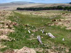
Shovel Down Ceremonial Complex
OS Map: SX 65970 85960
HER: No record found
Megalithic Portal: 10387
PMD: Shovel Down
ShortName: CX Shovel Down
Butler map: 36.6
DPD page: 139
Notes: Ceremonial complex including multiple stone rows and a small stone circle. Lethbridge pp.139-145. Interesting old sketches on the RAMM website: Emanuel Jeffery sketches of Shovel Down stone rows (1839) and Emanuel Jeffery sketch of Stone Row to Shovel Down Long Stone (1839)
Nearby sites: SX65978596
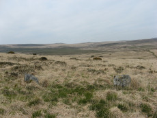
Shovel Down Stone Circle
OS Map: SX 65829 86196
HER record: MDV29944
Megalithic Portal: 1259
PMD: Shovel Down Stone Circle
ShortName: SC Shovel Down
Butler map: 36.6
DPD page: 139
Turner: G15
Notes: "The remains of an alleged stone circle lie on the gentle NE facing slope of Shovel Down 200m SW of Batworthy Corner. Three upright stones, between 0.3m and 0.75m high, are visible. The two close-set NE stones display smaller packing stones in the erosion hollows at their bases. The third stone is partly obscured by the bank of the South Hill Leat (SX 68 SW 97). It is possible that these stones constitute the remains of a stone circle however, no such feature is noted in the antiquarian records so it must remain a doubtful site". In fact a sketch of the Shovel Down rows made by Wilkinson in 1860 marks and illustrates "stones" at the location of the stone circle. For a photo, see Megalithic Portal: Shovel Down NW stone circle. Lethbridge pp.139-145, diagram p.139.
Nearby sites: SX65838620
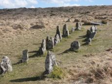
Shoveldown 1 Stone Row
OS Map: SX 66049 85707
HER record: MDV6181
Megalithic Portal: 2128
The Stone Rows of GB: Shoveldown 1
PMD: Shovel Down H-K Stone Row
ShortName: SR ShovelRow 1
Butler map: 36.7.1
DPD page: 139
Notes: Worth Row G, Butler Row 1. This row is considered to be one long partially robbed row. Previously listed here as Shoveldown D-G-H-J now Shoveldown 1 after Butler and Gerrard.
Nearby sites: SX66058571
Shoveldown 2 Stone Row
OS Map: SX 65955 86026
HER record: MDV6171
Megalithic Portal: 2129
The Stone Rows of GB: Shoveldown 2
PMD: Shovel Down A-B Stone Row
ShortName: SR ShovelRow 2
Butler map: 36.7.2
DPD page: 139
Notes: Worth Row A. Butler Rows 2.('B' SX 65968615 to SX 65968601) Double row to the east. Length 596 ft. Rows 3 ft 6in apart. Row is near Batworthy enclosure and has been much robbed; now just 12 pairs of stones and 15 single. Spacing of stones along the rows is around 6 ft. Two fallen stones next to the circle are much the largest in the row; one is 11 ft 6in, in length. and the other 7ft 4 in. The southern end of the row terminates in the Fourfold Circle (SX 68 NE 17). Lethbridge 139-145, diagram p.139.
Previously listed here as Shoveldown B now Shoveldown 2 after Butler and Gerrard.
Nearby sites: SX65968603

Shoveldown 3 Stone Row
OS Map: SX 65932 86073
HER record: MDV6168
Megalithic Portal: 2130
The Stone Rows of GB: Shoveldown 3
PMD: Shovel Down D-E Stone Row
ShortName: SR ShovelRow 3
Butler map: 36.7.3
DPD page: 139
Notes: Worth Row E, Butler Rows 3. ('A' SX 65898616 to SX 65938605). Double row to the west of row B. Length 476 ft. Rows just over 4 ft apart but distance varies considerably along length. No special feature marks either end. Much robbed and single now along much of its length. Lethbridge 139-145, diagram p.139.
Previously listed here as Shoveldown A now Shoveldown 3 after Butler and Gerrard. Photo included here previously (taken in 2010) had misidentified Shoveldown 4 for this row.
Nearby sites: SX65938607

Shoveldown 4 Stone Row
OS Map: SX 65998 85903
HER record: MDV14875
Megalithic Portal: 2127
The Stone Rows of GB: Shoveldown 4
PMD: Shovel Down C-F Stone Row
ShortName: SR ShovelRow 4
Butler map: 36.7.4
DPD page: 139
Notes: Worth Row C, Butler Rows 4. "('C' SX 65948601 to SX 65998590) A double row, 380 feet long, with an average distance of five feet between the rows. Most of the pairs of stones are complete and the southern end terminates in a barrow (SX 68 NE 34). No special feature marks the northern end."
Nearby sites: SX66008590
Shoveldown 5 Stone Row
OS Map: SX 66017 85840
HER record: MDV6179
Megalithic Portal: 2126
The Stone Rows of GB: Shoveldown 5
PMD: Shovel Down G Stone Row
ShortName: SR ShovelRow 5
Butler map: 36.7.5
DPD page: 139
Notes: Worth Row G, Butler Rows 5 & 6 ('E')SX 66028581 to SX 66028567) A double row, 485 feet long with 3 1/4 feet between the rows which run almost due north and south, and terminates in a standing stone known as the Longstone (SX 68 NE 39). Fairly complete at the northern end but more ragged towards the south.
Nearby sites: SX66028584
Shoveldown 6 Stone Row
OS Map: SX 66024 85681
HER record: MDV6148
The Stone Rows of GB: Shoveldown 6
PMD: Shovel Down South
ShortName: SR:ShovelRow 6
Butler map: 36.7.6
Notes: Previously listed here as Shoveldown Longstone to Three Boys Stone Row now Shoveldown 6 after Butler and Gerrard.
Nearby sites: SX66028568
Shoveldown D Reported Stone Row
OS Map: SX 66040 85680
HER record: MDV6145
Megalithic Portal: 2128
The Stone Rows of GB: Shoveldown 1
PMD: Shovel Down H-K Stone Row
ShortName: SR:ShovelRow D
Butler map: 36.7.1
DPD page: 139
Notes: Worth Row D, Butler Row 1. This row is considered to be one long partially robbed row - previously listed as four separate rows.
Nearby sites: SX66048568
Shoveldown H Reported Stone Row
OS Map: SX 65990 85950
HER record: MDV14881
Megalithic Portal: 2128
The Stone Rows of GB: Shoveldown 1
PMD: Shovel Down H-K Stone Row
ShortName: SR:ShovelRow H
Butler map: 36.7.1
DPD page: 139
Notes: Worth Row H, Butler Row 1. This row is considered to be one long partially robbed row - previously listed as four separate rows.
Nearby sites: SX65998595
Shoveldown J Reported Stone Row
OS Map: SX 65980 86030
HER record: MDV14882
Megalithic Portal: 2128
The Stone Rows of GB: Shoveldown 1
PMD: Shovel Down H-K Stone Row
ShortName: SR:ShovelRow J
Butler map: 36.7.1
DPD page: 139
Notes: Worth Row D, Butler Row 1. This row is considered to be one long partially robbed row - previously listed as four separate rows.
Nearby sites: SX65988603
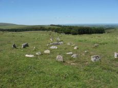
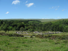
Shovel Down Fourfold Cairn Circle
OS Map: SX 65958 86025
HER record: MDV6158
Megalithic Portal: 3464
PMD: Fourfold Circle
Alternate name: Fourfold Circle Cairn Circle
ShortName: CC Shovel4Fold
Butler map: 36.7
DPD page: 143
Grinsell: GID 3
Turner: G31
Barrow Report: 56
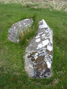
Notes: "Fourfold Circle a sub-circular configuration of four apparently concentric stone rings. The outer ring has a diameter of 9m, the others have diameters of 6.4m, 4.7m and 2.4m respectively. The monument comprises 29 visible stones. Most are approximately 0.3m in height although they vary from 0.1-0.55m. The middle two rings define the bottom and top of the scarp of a small earthern cairn apparently an integral part of the monument. It is most pronounced on the E (downslope side). In the centre is a roughly sub-circular pit measuring 1.3m by 0.7m and 0.45m deep; it is probably the remains of a badly robbed cist. On the N side are two large fallen stones. When upright they may have served as a focal point for the end of the stone row " Lethbridge 139-145, diagram p.139.
Nearby sites: SX65968603
Shovel Down Fourfold Circle Standing Stone
OS Map: SX 65958 86033
HER record: MDV6158
Megalithic Portal: 3464
PMD: Fourfold circle
Alternate name: Fourfold Circle Standing Stone
ShortName: SS Shovel Down
Butler map: 36.6
DPD page: 143
Barrow Report: 56
Notes: "The south end [of the double row] is aligned on a cairn 'Fourfold Circle' (SX 68 NE 17) and separated from it by two massive fallen stones, one 'needle-shaped' and similar to the 'Longstone' (SX 68 NE 39), southern terminal of stone row 'E'."
Nearby sites: SX65968603
Fourfold Circle (near) Reported Cist
OS Map: SX 65950 85990
HER record: MDV6160
PMD: S of Fourfold Circle
ShortName: CT?FourFoldNr
Butler map: 36.7
Grinsell: GID 3a
Notes: Worth mentions a small barrow 65 ft from the centre of 'Fourfold' cairn on the alignment of a double stone row. Radcliffe writes: Ormerod (1976) says a row "commences about 25 yds to the SW of the triple circle, and extends 110 yds to the ruins of a kistvaen".
Nearby sites: SX65958599
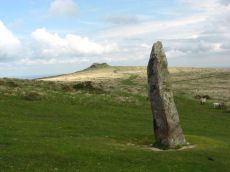
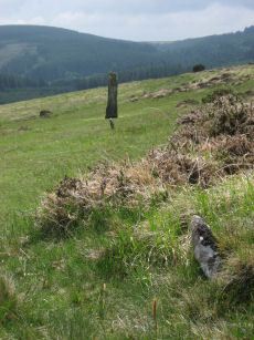
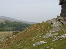
Shovel Down Long Stone Standing Stone
OS Map: SX 66031 85683
HER record: MDV6149
Megalithic Portal: 10378
PMD: Shovel Down
ShortName: SS Long Stone
Butler map: 36.6
Butler Vol 5: p.56 & Fig.34
DPD page: 140
Notes: The Long Stone has been used as a boundary stone but it appears to be the terminal stone for a Bronze Age stone row and it may be of a contemporary date. Grinsell [Folklore 1976]: At the beating of the bounds of Gidleigh Common, the first man to reach the Long Stone is (or was) given a money prize. Fielden 1933. The current author has been informed this tradition continues. See also, Legendary Dartmoor: The Shoveldon Longstone
Nearby sites: SX66038568
Three Boys Standing Stone
OS Map: SX 66028 85486
HER record: MDV6180
Megalithic Portal: 10369
The Stone Rows of GB: Shoveldown 6
PMD: Three Boys
ShortName: SS Three Boys
Butler map: 36.6
Notes: Terminal for stone row - one of 3 stones. 3 standing stones, of which only one remains; sometimes claimed as remains of burial chamber. This record has two entries, this one as a standing stone as widely reported, but also as reported cairn or tomb, see Three Boys Reported Cairn, SiteID=1268
Nearby sites: SX66038549
Three Boys Reported Cairn
OS Map: SX 66028 85486
HER record: MDV6180
The Stone Rows of GB: Shoveldown 6
PMD: Three Boys
ShortName: CT-Three Boy1
Butler map: 36.7
Grinsell: LYD 9a
Notes: 3 standing stones, of which only one remains; sometimes claimed as remains of burial chamber.This record has two entries, listed as standing stone, see Three Boys Reported Cairn, SiteID=20
Nearby sites: SX66038549
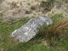
Shovel Down Cist
OS Map: SX 65993 85924
HER record: MDV6182
Megalithic Portal: 28953
PMD: Shovel Down
Alternate name: Shoveldown Rows 4 Cist
ShortName: CT Shovel Down
Butler map: 36.7
Butler Vol 5: p.223 & Fig.155
Grinsell: CHA 1
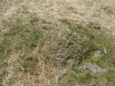
Notes: Robbed cist no longer visible. The Shovel down double row C (Worth Row C, Butler Rows 4) terminates at its southern end in a cairn - the cist has been robbed from the cairn. Visited 16/05/19 - a rectangular cist shaped hole can be clearly seen with reeds growing from it. No sign of a cist. Butler Shoveldown Rows 4 Vol. 2. Map 36.7 (diagram Vol. 5. p.223).
Nearby sites: SX65998592
Shoveldown nr stone row Reported Cairn
OS Map: SX 65930 86080
HER record: MDV13011
ShortName: CN:Shovel Do4
Turner: D30
Notes: "Abutting the west side of a double stone row is a circular depression 2m diameter, 0.2m deep. Perimeter lined with small earthfast slabs. It appears to be the kerb of a destroyed cairn or less probably an inner ring of orthostats of a larger now flat cairn which must then be partly overlaid by the stone row."
Nearby sites: SX65938608
Shovel Down Reave Reported Cairn
OS Map: SX 65970 85970
HER record: MDV6160
ShortName: CN?ShovelReave
Grinsell: B:CHA 1a
Notes: 'Cairn' S of fourfold circle, now known to be part of reave. Worth 1946b, pl.3. Probably a duplicate of GID 3a, see Fourfold Circle (near) Reported Cist.
Nearby sites: SX65978597
Shoveldown Central Settlement Reported Cist
OS Map: SX 65764 85857
HER record: MDV54531
PMD: Shovel Down W.
ShortName: CT:ShovelSet
Butler map: 36.4
Notes: This cairn is described by Butler on p. 176. "Forty metres outside the south-west corner a small solitary cairn (5.0 x 0.3m) has been dug into, the displaced stones subsequently returned to the central pit where they lie in a loose pile". The cairn is shown on Fig 36.4 on p.176. It can be seen to be a few metres south of the Central Settlement. It also appears towards the top left on Fig 36.7 on p. 179. Fig 36.4 is a segment of Fig 36.7. Butler lists this site as a cist at SX 6576 8585.
Nearby sites: SX65768586

Shovel Down Settlement
OS Map: SX 65800 85900
HER record: MDV6163
Megalithic Portal: 10386
ShortName: ST ShovelDown
Butler map: 36.4
Nearby sites: SX65808590
Central Settlement Reported Cairn
OS Map: SX 65700 86240
HER record: MDV134083
ShortName: CN?Central S1
Butler map: 36.4
Notes: Butler: "Another cairn, apparently undug, lies on the open hillside 250 m north of the enclosures downhill from several vry low mounds, all possible burial cairns".
Nearby sites: SX65708624
Shoveldown N.W Cairnfield Master
OS Map: SX 64350 86100
HER record: MDV28132
ShortName: CN:ShovelNW M
Notes: Cairn cemetery on Long Ridge between Stonetor Brook and the North Teign River with eight cairns, one with a cist.
Nearby sites: SX64358610
Shoveldown N.W. 1 Cist
OS Map: SX 64389 86247
HER record: MDV4394
Megalithic Portal: 45782
PMD: Stonetor Hill
Alternate name: Shoveldown N.W.1 Cist
ShortName: CT:ShovelNW 1
Butler map: 37.5.1
Butler Vol 5: p.202 & Fig.145
Grinsell: GID 1
Notes: NB. NGR from PMD is SX64398640. "The remains of a Bronze age cairn and cist which form part of a cairn cemetery on Long Ridge, known locally as Langridge, overlooking the valley of the River North Teign. The cairn has a circular mound which measures 5.2 metres in diameter and 0.5 metres high. The cist measures 0.83 metres square by up to 0.47 metres deep. The capstone, which once covered the cist, now lies 0.7 metres NNW of the cist." Butler Shoveldown N.W.1. - Vol. 2. Map 37.5. (diagram Vol. 5. p.202).
Nearby sites: SX64398625
Shoveldown N.W.2 Cairn
OS Map: SX 64310 86300
HER record: MDV54501
ShortName: CN:ShovelNW 2
Butler map: 37.5.2
Notes: "a turf-covered cairn on the gentle w-facing slope of langridge overlooking the north teign river. It measures 5.5m in diam with a maximum height of 0.6m. The steeply sloping sides give way to a virtually flat top with a slight hollow sw of centre. There are no obvious signs of robbing or excavation (probert)"
Nearby sites: SX64318630
Shoveldown N.W.3 Cairn
OS Map: SX 64360 86250
HER record: MDV58684
ShortName: CN:ShovelNW 3
Butler map: 37.5.3
Notes: HER: Cairn of 4.1 metres by 4.5 metres and 0.5 metres high forming part of cairn cemetery on Long Ridge.
Nearby sites: SX64368625
Shoveldown N.W.4 Cairn
OS Map: SX 64380 86120
HER record: MDV4395
ShortName: CN:ShovelNW 4
Butler map: 37.5.4
Grinsell: GID 2
Notes: "The n cairn, probably that described by os and grinsell, measures 4.5m in diam and stands a maximum of 0.55m high. It possesses steep sides with some protruding stone and a very slightly hollowed centre. There are no obvious signs of disturbance (probert)"
Nearby sites: SX64388612
Shoveldown N.W.5 Cairn
OS Map: SX 64390 86110
HER record: MDV54481
ShortName: CN:ShovelNW 5
Butler map: 37.5.5
Notes: "a probable mutilated cairn measures 3.6m n-s by 4.2m and 0.5m high on the n by 0.15m on the s. Though disturbed there is no distinct hollow usually associated with deliberate robbing. Some small stones protrude from the mound (probert)".
Nearby sites: SX64398611
Shoveldown N.W.6 Cairn
OS Map: SX 64350 85930
HER record: MDV58683
ShortName: CN:ShovelNW 6
Butler map: 37.5.6
Notes: HER: Round cairn of 5.3 metres diameter by 0.7 metres high forming outlying part of cairn cemetery on Long Ridge. Large number of quartz rocks visible within small disturbance in the centre of the mound
Nearby sites: SX64358593
Shoveldown N.W.7 Cairn
OS Map: SX 64230 86220
HER record: MDV37096
ShortName: CN:ShovelNW 7
Nearby sites: SX64238622
Shoveldown N.W.8 Cairn
OS Map: SX 64520 85920
HER record: MDV58285
ShortName: CN:ShovelNW 8
Nearby sites: SX64528592
Shoveldown N.W.9 Cairn
OS Map: SX 64410 86110
HER record: MDV54480
ShortName: CN:ShovelNW 9
Notes: HER: Eastern of three cairns of 3.9 metres diameter by 0.6 metres high within the cairn cemetery on Long Ridge ... Two well-preserved cairns and a further probable cairn lie in an area of low heather and long tufty grass on the gentle N-facing slope of Langridge.
SX 64418611. The E cairn, 3.9m in diameter and 0.6m high, is similarly steep-sided with two large boulders embedded in the otherwise flat top. A single upright stone, possibly part of a former kerb, is situated in the edge of the cairn.
Nearby sites: SX64418611

Thornworthy Corner (N) Cist
OS Map: SX 66113 85468
HER record: MDV6183
Megalithic Portal: 45776
PMD: Downhill from Three Boys
Alternate name: Thornworthy Corner N. Cist
ShortName: CT Thornwort N
Butler map: 36.7
Grinsell: CHA 2
Notes: "Recorded as a cist by Worth (1932), based on the one remaining stone. 1991 survey thought it more likely the result of stone clearance for the nearby newtake wall" Butler Vol. 2. Map 36.7.
Nearby sites: SX66118547
Thornworthy Corner W. Cairn Circle
OS Map: SX 65990 85500
HER record: MDV48855
ShortName: CN?Thornwort W
Butler map: 36.7
Grinsell: LYD 9
Turner: A24
Notes: HER: Ring cairn of 6.0 metres diameter with bank 1.8 metres wide by 0.6 metres high on Shovel Down
Nearby sites: SX65998550

Stonetor Hill Cairn Circle
OS Map: SX 65244 85468
HER record: MDV49461
Megalithic Portal: 52273
Alternate name: Stonetor Hill 1 Cairn Circle
ShortName: CC Stonetor 1
DPD page: 133
Turner: G12
Notes: Dubious site. "Two upright slabs situated in the shallow valley bottom above the headmire of the E arm of the Stonetor Brook. The slabs, 1.2m high, are positioned in line 1.0m apart and lie on the boundary of Gidleigh Parish and the Forest of Dartmoor, now Dartmoor Forest parish. The N face of the E stone has the letters 'GP' (Gidleigh parish). The S face is lichen covered. A deep water filled erosion hollow lies on the N side of these stones". Possibly site listed as Stone Circle G12 by Turner. For a photo of this site, see Boundary stone on Stonetor Hill
Nearby sites: SX65248547
Stonetor Hill 2 Cairn
OS Map: SX 65250 85380
HER record: MDV58358
ShortName: CN:Stonetor 2
Nearby sites: SX65258538
Stonetor Hill 3 Reported Cairn
OS Map: SX 65250 85380
HER record: MDV58359
ShortName: CN:Stonetor 3
Notes: Round cairn situated at the head of the valley between shovel down and stonetor hill. Diam 4m, width 1m, depth 0.1m. This cairn lies 0.6m from a leat embankment. A 1m wide and 0.1m deep trench orientated ne-sw cuts through the centre of the mound from side to side. Formerly listed here as a duplicate of HER 58358 but that appears to be a mistake as this cairn is trenched and the other one is not.
Nearby sites: SX65258538
Stonetor Hill Stone Ring Cairn Circle
OS Map: SX 65200 85360
HER record: MDV48856
Megalithic Portal: 3478
Alternate name: Stonetor Hill 4 Stone Ring Cairn Circle
ShortName: RC:Stonetor 4
DPD page: 133
Turner: A3
Notes: Possible pound? "The feature consists of a sub-circular earthern bank 25m in diameter and up to 0.4m in height. It is best preserved on the North side where the bank is well defined, flat topped and has a plan width of about 4.0m On the South side the bank has been spread and flattened but still survives to 0.5m in height as a prominent outward-facing scarp, where the natural ground surface falls away from the enclsure. There is no entrance through the bank."
Nearby sites: SX65208536

Stonetor Brookhead E.1 Cairn
OS Map: SX 65324 85630
HER record: MDV13027
ShortName: CN Stonetor E1
Butler map: 37.2.1
Notes: ?
Nearby sites: SX65328563

Stonetor Brookhead E. Cist
OS Map: SX 65279 85642
HER record: MDV13023
Megalithic Portal: 45807
PMD: Stonetor Brook Head
Alternate name: Stonetor Brookhead E.2 Cist
ShortName: CT Stonetor E2
Butler map: 37.2.2
Butler Vol 5: p.201 & Fig.144
DPD page: 133
Notes: "A mutilated cist situated amongst peat cuttings on the moderate W slope of shovel Down. Only the N endstone, 0.6m long, remains in situ on the edge of a hollow 1.1m N-S by 0.9m and 0.2m deep. An irregular slab 0.15m thick, probably the disturbed coverstone, lies propped up on the endstone. There is no trace of a covering cairn". Lethbridge diagram p.133 and photo top p.133. Butler Vol. 2. Map 37.2 (diagram Vol 5 p.201).
Nearby sites: SX65288564
Wallabrook Bridge 1-9 Cairnfield Master
OS Map: SX 64500 86800
HER record: MDV28132
ShortName: CN:WallabrookM
Nearby sites: SX64508680
Wallabrook Bridge 1 Cairn
OS Map: SX 64635 86994
HER record: MDV34258
ShortName: CN:Wallabrook
Nearby sites: SX64648699
Wallabrook Bridge 2 Cairn
OS Map: SX 64608 86962
HER record: MDV34259
ShortName: CN:Wallabrook2
Nearby sites: SX64618696
Wallabrook Bridge 3 Cairn
OS Map: SX 64577 86932
HER record: MDV34260
ShortName: CN:Wallabrook3
Nearby sites: SX64588693
Wallabrook Bridge 4 Cairn
OS Map: SX 64554 86897
HER record: MDV34261
ShortName: CN:Wallabrook4
Nearby sites: SX64558690
Wallabrook Bridge 5 Cairn
OS Map: SX 64447 86944
HER record: MDV34262
ShortName: CN:Wallabrook5
Nearby sites: SX64458694
Wallabrook Bridge 6 Cairn
OS Map: SX 64511 86871
HER record: MDV34263
ShortName: CN:Wallabrook6
Nearby sites: SX64518687
Wallabrook Bridge 7 Cairn
OS Map: SX 64458 86912
HER record: MDV34264
ShortName: CN:Wallabrook7
Nearby sites: SX64468691
Wallabrook Bridge 8 Cairn
OS Map: SX 64462 86847
HER record: MDV34265
ShortName: CN:Wallabrook8
Nearby sites: SX64468685
Wallabrook Bridge 9 Cairn
OS Map: SX 64455 86815
HER record: MDV34266
ShortName: CN:Wallabrook9
Nearby sites: SX64468682
Kestor Enclosed Settlement
OS Map: SX 66397 86846
HER record: MDV6114
Megalithic Portal: 4617
ShortName: ST Kestor
Notes: The Kestor Settlement includes the Round Pound.
Nearby sites: SX66408685
Kes Tor Reported Cairn
OS Map: SX 66532 86276
HER record: MDV21222
Alternate name: Kestor Reported Cairn
ShortName: CN-Kestor
Notes: "Possible tor cairn beneath sheer nw scarp of kes tor. Composed of even-sized smallish stones. Approx 12m diameter, c 2m high, though the surrounding scree makes accurate measurement difficult."
Nearby sites: SX66538628

Thornworthy Reported Stone Row
OS Map: SX 66375 85001
HER record: MDV6666
ShortName: SR Thornworthy
Notes: HER: A series of large stones set into a prominent field bank of a field system. It was alleged to be a stone row but this is thought unlikely. OS(1978): (SX 664850 to SX 663849) 'Stone Row' (NR) (1971 OS map).(10/02/1978) This recent publication entry (not on OS 25" 1904 or OS 6" 1961) is not a stone row but refers to some large stones set at irregular intervals along the course of a prominent field bank of a field system oriented on Thornworthy Tor (SX 68 NE146). The author located this feature on 03/03/2025 with Steve Szypko and we concluded this is regular stones in a reave, most probably prehistoric, but not a stone row.
Nearby sites: SX66388500

Thornworthy Reported Stone Circle
OS Map: SX 65930 85035
HER: No record found
ShortName: SC Thornworthy
Notes: Possible stone circle at Thornworthy reported by Sam Goodwin on a Facebook posting. The HER entry MDV6666 perhaps relates to this feature, a discounted reported stone row.
Nearby sites: SX65938504
Page last updated 10/12/24