
Guide to the Hentor & Shavercombe Brook Cists
There are 8 cists in the vicinity of Hentor and the Shavercombe Brook (SX59566580 Butler Vol. 3. Map 49, 22).
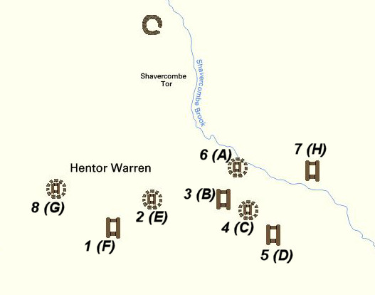
Diagram of the Hentor & Shavercombe Brook Cists
Bibliography & references
Butler, J. Dartmoor Atlas of Antiquities: Vol. 3. - The South-West (Devon Books, 1994)
Butler, Jeremy, Dartmoor Atlas of Antiquities, vol.5: The Second Millennium B.C., (1997)
Grinsell, L.V., Dartmoor Barrows, Devon Archaeological Society Proceedings No. 36 (1978)
Lethbridge, W.D. Discover Prehistoric Dartmoor (Halsgrove, 2015)
Pettit, Paul, Prehistoric Dartmoor, (1974)
Worth, R.H. Worth's Dartmoor (David & Charles, 1971)
Worth, R.H. Nineteenth Report of the Barrow Committtee Report & Transactions of the Devonshire Association Vol. 32 (1900)
Worth, R.N. Twelfth Report of the Barrow Committtee Report & Transactions of the Devonshire Association Vol. 22 (1890)
External Links
Excavation of Deadman's Bottom Cairns & Cists
Extract from nineteenth report of the Barrow Committee
NINETEENTH REPORT OF THE BARROW COMMITTEE
Nineteenth Report of the Committee, consisting of Mr P. F. S. Amery, Rev. S, Baring-Gould, Dr. Brushfield, Mr. R. Burnard, Mr. Cecil M. Firth, Mr. J, Brooking Rowe, and Mr. R. Hansford Worth (Secretary), appointed to collect and record facts relating to Barrows in Devonshire, and to take steps, where possible, for their investigation.
Edited by R. H. Worth, Hon. Secretary (Read at Totnes, August, 1900.)
Your Committee's Report for the year 1899-1900 has reference to the examination of a number of previously-rifled kistvaens in the moorland valley of the Plym. In addition to the kistvaens now described there are others in the same valley which require examination, and would have been reported on but that an excessive rainfall during the spring and early summer of the present year delayed the work.
RIFLED KISTVAENS IN THE PLYM VALLEY, DARTMOOR
The moorland valley of the Plym is rich in evidences of prehistoric man. With slight reservation it may be said that no more is to be learnt from an archaeological survey of the whole of Dartmoor than from a thorough investigation of this restricted area.
Within the catchment may be found hill-forts, pounds, very numerous hut circles, at least one "sacred circle," single and double stone rows, menhirs, barrows of all sizes, from the great "Giant's Basin" at Drizzlecombe to mere mounds of 15 feet diameter and under, and kistvaens; while, regarding the last, there is no other equal area of Dartmoor which affords such frequent examples.
PLATE 1
PLATE 2
PLATE 3
A number of these kistvaens have been broken into at unknown dates, the kists dug out, and their contents dispersed. The only apparent motive assignable for this spoliation would be the search for treasure, since, as will be seen later, the depredators in many cases ignored such relics as had no intrinsic value.
Did these treasure-hunts produce any valuable results? For obvious reasons it was the policy of the excavators to abstain from spreading abroad reports of their proceedings, and local tradition is entirely silent on the matter.
The consistent manner in which every discoverable kist or barrow has been ransacked would seem to suggest that occasional profit must have been derived from the proceeding, but this argument fails to be conclusive when it is remembered that there is no evidence confining the barrow-opening to any one period.
Generation after generation may have taken part in the search, individuals may have been discouraged, and abandoned it for more profitable occupations; but the lesson of their wasted labour would not necessarily deter their successors, even if known to them.
The question is unanswerable from insufficiency of data! The period at which the various barrows and kistvaens have been opened is equally obscure. It may seem a fair presumption that they remained undisturbed while any sanctity attached to them. The race that erected would probably not destroy until after the lapse of most considerable time. The amount of peat soil now to be found in many of the opened kists affords no real indication, for, although it would take long to accumulate, much of the spoil derived from excavation may have fallen back almost immediately after the search was abandoned.
Since there exists a licence to investigate certain barrows in Devon, granted in l324, [1] at least thus early the idea prevailed that treasure might be hidden therein.
Nine kistvaens have been thoroughly examined for the purposes of the present Report; of these, two only will be found marked in the Ordnance Survey. The following table, giving the number of the six-inch quarter-sheet on which each kistvaen should be marked, and the approximate latitude and longitude of each, will enable anyone who so wishes to indicate their positions with fair accuracy on the Ordnance sheets as now published.
[1] Eighth Report of Barrow Committee, Trans. Devon, Assoc, 1886.
TABLE GIVING APPROXIMATE LATITUDE AND LONGITUDE OF KISTVAENS.
| Distinguishing No. | Site. | No. of Quarter-sheet, 6" 0.S. | Longitude W. | Latitude N. |
|---|---|---|---|---|
| 1 | Wigford Down | CXII. S.E. | 4° 8' 4.5" | 50° 27' 39.5" |
| 2 | Guttor | CXII. S.E. | 4° 0' 16" | 50° 29' 0" |
| 3 | Lee Moor | CXII. S.E. | 3° 59' 50" | 50° 28' 12.5" |
| 4 | Drizzlecombe | CXII. S.E. | 3° 59' 15" | 50° 29' 0" |
| 5 | Drizzlecombe | CXII. N.E. | 3° 59' 8" | 50° 29' 13.5" |
| 6 | Langcombe, near Plym Steps | CXIII N.W. | 3° 58' 10" | 50° 29' 12" |
| 7 | Langcombe, near Deadman's Bottom | CXIII N.W. | 3° 57' 48" | 50° 29' 4" |
| 8 | Langcombe, near Deadman's Bottom | CXIII S.W. | 3° 57' 48" | 50° 29' 4" |
| 9 | Calveslake | CXIII N.W. | 3° 57' 41.5" | 50° 29'26" |
The order adopted is a progression from west to east. Certain other kistvaens lie within the same range and will, it is hoped, be dealt with in next year's Report
Throughout the following descriptions feet and inches are the units of measurement for kists, circles, etc., centimetres and millimetres for objects found therein, and all bearings have reference to true north.
1. Wigford Down (Plate II.)
This kistvaen lies within a circle of stones on the southern slope of Wigford Down, outside the inclosure of Cadworthy Farm. It is well constructed, has been opened previously, and the cover-stone still partially overhangs the kist. Originally it was evidently covered by a barrow, consisting, in part at least, of stones. The dimensions of the kist are: length, 3 feet 6 inches; breadth, 1 foot (the breadth at floor-level is 2 feet 3 inches); depth to floor, 2 feet.[2] The diameter of the circumscribing circle is 20 feet, direction of length of kistvaen 74 degrees west of north.
Careful search yielded two fragments of pottery, evidently portions of an urn. These are illustrated in Plate I., Figs. 1 and 2. The pottery is of the same type in ornament and material as that found at Legis Tor in the hut circles. The thickness of the material is 6 mm.
2. Guttor, otherwise Gutter Tor (Plate III.)
A kistvaen of which three sides only have been left standing. Length, 2 feet 9 inches; length at present ground-level, 3 feet 3 inches; breadth, (?) 1 foot 8 inches; depth to floor, 1 foot 10 inches; direction of length of kistvaen, 18 degrees west of north. No result from excavation.
[2] All dimensions given are inside measurements, unless otherwise stated. All depths are measured from top of side-stones, all widths and lengths at top of kist.
PLATE 4
PLATE 5
PLATE 6
PLATE 7
3. Lee Moor (Plate IV.)
Described in preceding table as being on Lee Moor, but does not lie within the area best known by that name. It is in the Valley of Wallabrook, 51 feet north of the Cornwood Reeve (which circles round Trowlesworthy, and is continued to the east of Wallabrook by a hedge of Hentor Farm), and lies 832 feet west of the brook measured along the reeve. Neither the reeve nor kistvaen is shown on the Ordnance Map, and the stream is thereon marked Hentor Brook.
Three sides of this kistvaen remain in place; the western side has been pushed back, and the cover-stone removed. The length of the kistvaen at floor-level is 3 feet; the end stones have fallen over, and are only 1 foot 8 inches apart at top. The width at the south end was 1 foot 9 inches, at the north end 1 foot 5.5 inches; depth to floor, 2 feet 6 inches. Direction of length 48 degrees west of north. No result from excavation.
The contents of this kistvaen had been recently disturbed; if by an archaeologist, it is hoped that results may be communicated to your Committee.
4. Drizzlecombe (Plate V.)
Only two sides of this kistvaen remain in place; it forms the extreme south-western member of the group of cairns, barrows, kistvaens, menhirs, and stone rows in the Drizzlecombe Valley.
Length of eastern side-stone, 5 feet 1 inch; length of western side-stone, 5 feet; distance apart south end, 1 foot 8 inches; distance apart north end, 1 foot 10 inches; direction of length, 78 degrees west of north.
On excavation two fragments of pottery were discovered (Plate I., Figs. 3 and 4). No ornamentation is visible. The outer side of the urn is bright red, and was probably finished in selected clay. Thickness of material, 4 mm. A rather more careful work than most of the pottery from the hut circles in Plym Valley.
Beyond an exceptional number of stones in the surrounding soil, and a large number found in the kistvaen itself, there is now no trace of the barrow which probably covered this kist
5. Drizzlecombe (Plate VI.)
A very fine example. The cover-stone has been removed, and overhangs a portion of the kist. Length of kistvaen, 2 feet 9 inches; length at floor-level, 4 feet 4 inches; width, 2 feet 3 inches; width at floor-level, 2 feet 10 inches; depth to floor, 2 feet 8 inches; direction of length, 38 degrees west of north.
No result from excavation.
This kistvaen stands in a barrow mainly formed of stone, and of diameter 35 feet.
TWENTIETH REPORT OF THE BARROW COMMITTEE
Twentieth Report of the Committee, consisting of Mr. P. F. S. Amery, Rev. S. Baring-Gould, Dr. Brushfield, Mr. R. Burnard, Mr. Cecil M. Firth, Mr. J. Brooking-Rowe, and Mr. R. Hansford Worth (Secretary), appointed to collect and record facts relating to Barrows in Devonshire, and to take steps, where possible, for their investigation.
Edited by R. H. Worth, Hon. Secretary. (Read at Exeter, 3lst July, 1901.)
RIFLED KISTVAENS IN THE PLYM VALLEY, DARTMOOR.
(Continued from Nineteenth Report.)
The following errors in last year's Report have already appeared in Errata et Corrigenda appended to the Index of vol. xxxii. The corrections are here repeated for those who may have only reprints, or may bind reprints in one volume.
Page 52, line 10 (page 7 of reprint), "Nos. 8 and 9 and circles adjacent." This should be "Nos. 7 and 8 and circles adjacent." Throughout this section, as far as line 29 on page 53 (page 8 of reprint), "No. 8" or "8" should read "No. 7" or "7," and "No. 9" or "9" should read "No. 8" or "8" wherever referring to kistvaens.
Five kistvaens are described in the present Report; of these, two are marked on the six-inch Ordnance sheets. The following table gives the number of the six-inch quarter-sheet, on which each kistvaen should be marked, and the approximate latitude and longitude of each:
| Distinguishing No. | Site. | No. of Quarter-sheet, 6" 0.S. | Longitude W. | Latitude N. |
|---|---|---|---|---|
| 10 | Legis Tor | CX II. S.E. | 4° 0' 40" | 50° 28' 17" |
| 11 | Hentor | CXIII S.W. | 3° 58' 54" | 60° 28' 81" |
| 12 | Shavercombe | CXIII S.W. | 3° 58' 42" | 60° 28' 27.75 " |
| 13 | Great Gnat's Head | CXIII S.W. | 3° 57' 27.5" | 49° 29' 41.5" |
| 14 | Grim's Grave, Langcombe | CXIIL S.W. | 8° 57' 22" | 60° 28' 49.75" |
Table giving approximate latitude and longitude of kistvaens
Throughout the following descriptions all bearings have reference to true north. The order adopted is a progression from west, to east, starting, as in last year's Report, at the extreme western end of the valley.
Beading the two Reports together, the actual order in which the kistvaens occur is 1, 10, 2, 3, 4, 5, 11, 12, 6, 7, 8, 9, 13, 14.
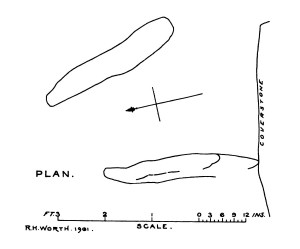
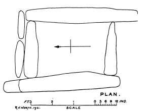
10. Legis Tor (Plate XII.)
This kistvaen lies in a direction approximately 17 degrees south of east from the summit of Legis Tor and at a distance of 250 yards. The width between the side-stones at the north end is 1 foot 9 inches, and at the south end 3 feet 4.5 inches; but these measurements are taken from end to end of the stones and not at right angles to their direction. The eastern side-stone is 3 feet 1 inch in length and the western is 3 feet 4 inches long. No end-stones remain, and therefore the true length is unobtainable. The eastern side-stone is still firmly set, but the western has apparently been somewhat displaced.
To the south of the kist lies the cover-stone, of which the greatest length is 5 feet 4 inches, the greatest width 4 feet 2 inches.
Direction of length of eastern side-stone, 19 degrees west of north.
This kistvaen was opened when the Legis Tor hut circles were being examined in 1896, and gave no yield of either flint, pottery, ash, or charcoal.
Its chief peculiarity is that it has been built on an earth-fast boulder, the surface of which is some little distance below ground-level and forms a stone floor to the kist.
It was originally covered by a barrow, the present diameter of which is 16 feet
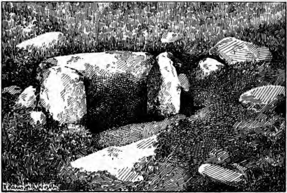
Plate 13 Hentor: VIEW. Looking 60° E of N
11. Hentor (Plate XIII.)
On the northern slope of Hentor, not far from the Shavercombe kistvaen (12), which is marked on Ordnance map. One side and both ends of this kistvaen still stand, and the cover-stone lies hard by. The south-eastern end-stone, which had partly fallen inwards, was re-erected after the kist had been excavated.
The dimensions of this kistvaen are: length, 2 feet 3 inches; breadth, 1 foot 4 inches at north-western end, 6.5 inches at south-eastern end, this last dimension being somewhat remarkable. In order to partly compensate for the extreme narrowness, it appears that the side-stone still standing has always leant towards the end-stones, and so given about 8 inches more width at the floor of the kist. The other side-stone may have been similarly set, but only one half of this remains, it having been broken along its length at some unknown date. The half remaining was buried in refilling the kistvaen. Direction of length, 63 degrees west of north. Result of excavation, the remains of a modern pocket-knife, apparently one lost by the author in 1889.
This kistvaen has been covered by a barrow, and apparently surrounded by a stone circle having a diameter of 11 feet.
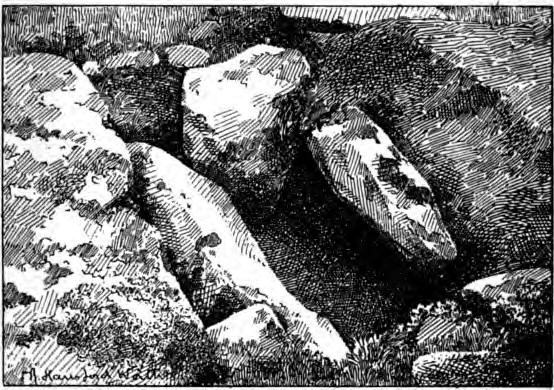
Plate 14 Shavercombe: VIEW. Looking 28° E of S
12. Shavercombe (Plate XIV.)
Marked on Ordnance Survey. Two sides, one end-stone, and the cover-stone remain. The kist has been covered by a barrow, and lies in a stone circle of 10 feet 6 inches diameter.
The eastern side-stone had fallen against the western and completely closed the kist. This stone was, last year, turned back to admit of excavation, and has been left so.
Dimensions not properly ascertainable; length, probably 3 feet; breadth, at south end, probably 1 foot 6 inches; depth, which alone could be exactly ascertained, 2 feet 8 inches ; direction of length of kistvaen, 26 degrees west of north.
No results from excavation.
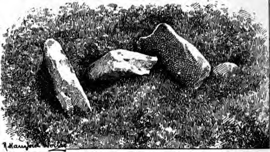
Plate 15 Great Gnats Head: VIEW. Looking 63° E of S
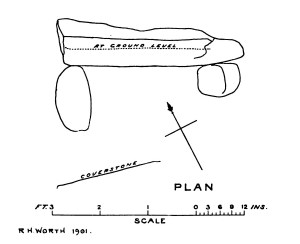
13. Great Gnat's Head (Plate XV.)
Four hundred and thirty-three yards S.S.E. from Plym Ford (on the Abbot's Way). May be most readily found by keeping the summit of Lower Harter in line with northern side of pile of rocks crowning Legis Tor.
Consists of two sides and one end-stone. The sides have fallen apart, which is unusual; and the end-stone, which leant well over the kist, ultimately falling in consequence of the operations of excavation, has now been set in approximately vertical position.
Dimensions not properly ascertainable: length, probably 2 feet 8 inches to 3 feet; breadth, probably 2 feet 5 inches; depth, which alone could be exactly ascertained, 2 feet 7 inches; direction of length, 78 degrees west of north.
No results from excavation.
In the approximate centre of this kistvaen a pit had at some time been sunk 1 foot 5 inches below the level of the floor, or 4 feet below the upper edge of the side-stones. Similar pits were found in 11, 12, and 14, but if original they had been entirely cleared out by previous searches, for not even ashes were to be found in them.
No trace of the barrow remains round this kistvaen.
Twenty feet from the centre of this kistvaen, in a direction 30 degrees west of south, lies the centre of a small barrow of 9 feet diameter.
This barrow was carefully examined, and proved to cover a circular, carefully paved area, while beneath the flat paving-stones lay a large flat stone which closely resembled the cover-stone of a kistvaen. This latter, however, rested on the "calm" or subsoil everywhere, and covered neither a pit in the "calm" nor a kistvaen. The indications are that this paved area corresponds to the circles found in connection with kistvaens 7 and 8, Deadman's Bottom, Langcombe.
A layer of peat between the upper paving-stones and the subsoil may probably account for the fact that the latter shows no sign of alteration by heat.
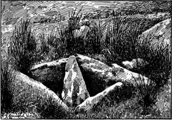
Plate 16 Great Gnats Head: VIEW. Looking S. W.
Grim's Grave, Langcombe (Plate XVI.)
Shown on Ordnance Survey. A fine and perfect specimen, standing in a mound surrounded by a circle of nine stones, all standing; diameter of circle 18 feet.
The author has elsewhere[1] described the cover-stone of this kistvaen as trimmed square to fit it.
[1]"The Moorland Plym," Trans. Plymouth Inst, 1889-90.
The cover-stone lay diagonally across the kist, and has now been lifted out and lies within the circle on the south side. It proves that two cover-stones were used, neither of which was in any apparent way trimmed or dressed to fit the kist. A good instance of the necessity for thorough examination.
Dimensions of kist: length, 3 feet 1.25 inches to 3 feet 6.5 inches; breadth, 2 feet 6 inches to 2 feet 7.5 inches; depth before excavation, 2 feet; original depth, 3 feet 3 inches; direction of length, 1 degree east of north.
No result from excavation, but a flint flake was found on the surface of the ground within a few feet of the kistvaen.
The southern end-stone was disturbed in order to permit the cover-stone to be removed from within the kist, but has been replaced in its original position, which was carefully marked, and is absolutely secure.
This exhausts the list of previously rifled kistvaens at present known to exist in the Plym valley, the author having been in error in stating, in the paper previously referred to, that a second kistvaen existed on Wigford Down, near the summit; another case of deceptive appearances.
We now have details of fourteen kistvaens in this one valley, and the opportunity may be taken to see how far any uniformity of orientation exists, as has sometimes been claimed. The following table gives the direction of length of each of the fourteen kistvaens as referred to the true north:
| 14 | Grim's Grave | 1° E. of N. |
| 2 | Guttor | 18° W. of N. |
| 10 | Legis Tor | 19° W. of N. |
| 12 | Shavercombe | 26° W. of N. |
| 7 | Deadman's Bottom | 30° W. of N. |
| 6 | Langcombe | 41° W. of N. |
| 3 | Lee Moor | 48° W. of N. |
| 5 | Drizzlecombe | 53° W. of N.[2] |
| 9 | Calveslake | 57° W. of N. |
| 11 | Hentor | 63° W. of N. |
| 8 | Deadman's Bottom | 66° W. of N. |
| 1 | Wigford Down | 74° W. of N. |
| 4 | Drizzlecombe | 78° W. of N. |
| 13 | Great Gnat's Head | 78° W. of N. |
The accompanying figure gives graphically the information contained in the above table.
Within one degree the directions of length all fall between N. and W. and S. and E, being limited to rather less than the N.W. and S.E. quadrants.
A range of 70 degrees, however, does not accord well with any conception of uniformity, and the case of the two kistvaens at Deadman's Bottom, where the difference in direction is 36 degrees, although only a trifle over 30 feet intervenes, emphasises the diversity.
[2] Incorrectly stated as 38° W. of N. in the Nineteenth Report.
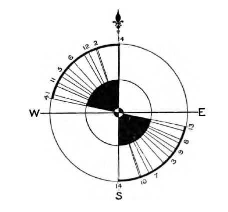
With the exception of 10, Legis Tor, no one kistvaen points even approximately to any hilltop ; it might however, be claimed that in this case an attempt was made to point to Little Trowlesworthy Tor, and were there confirmatory instances the claim might be granted. As it stands it is probably a coincidence and no more.
The rising, the setting, and the midday sun are alike unavailable as objects from which the directions of these kistvaens might have been determined, even after allowing seasonal variation in position and the further local variations due to an irregular horizon.
It remains, none the less, that not only in this valley, but all over Dartmoor, the general direction in length of kiatvaena (with some few exceptions) lies within the N.W. and S.E. quadrants of the corrected compass. (R. H. Worth.)

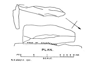
Grim's Grave Ring Setting Cairn and Cist
Page last updated 10/12/16