
Hentor B Cist
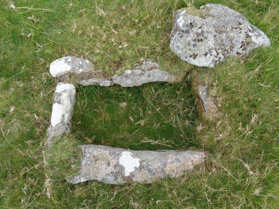
Photo taken on 13-08-2017
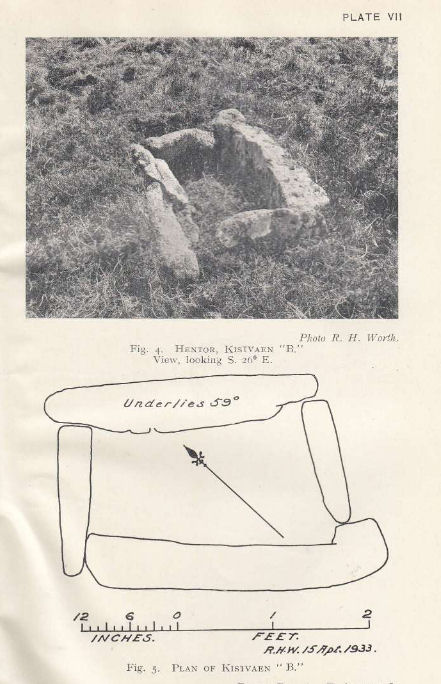
Plan by RHW. Barrow Report 52. TDA Vol.65 1933
Database entries
PDW coverage: Dartmoor Site: Guide to the Hentor & Shavercombe Brook Cists
OS Map: SX 59567 65806
OS Source: Garmin
Butler OS: SX59566579
HER: MDV3490
Megalithic Portal: 45727
PMD: Hen Tor Warren 3
Alternate name: Hen Tor N.3
Short Name: CT Hen Tor N 3
Butler map: 49.22.3
Dixon Cist #: 51
Grinsell: SHAUGH PRIOR 28
DPD page: 49
Exist: Yes
Record: Unique
Record Source: Butler
Hut Class: No
Cist Class: Yes
Cairn Class: Yes
Barrow Report: 52
Dimensions (m): 3.0 x 0.3 C
Lidar: SX 59567 65806
Guide Map: 49
Nearest Bus Stop: Lee Moor Clearview (6.0 km) [Route: 59]
Nearby sites: SX 59567 65806
Notes
"The cairn measures 4.7m in diameter and 0.5m high. The cist, aligned north west to south east, measures 0.8m by 0.4m and is 0.3m deep. A probable coverstone 2.0m to the north measures 0.9m by 0.7m". Lethbridge p.49 Shavercombe Cist B - diagram p.49. Butler Hen Tor 3 (Cairn 3) - Vol. 3. Map 49.22 (general plan of Hen Tor with diagram of cists pp.146-7).References
These are selected references with an emphasis on out of copyright sources linked as PDFs. For more detailed references try any linked HER or PMD record above.
- Butler, Jeremy, Dartmoor Atlas of Antiquities, vol.3: The South-West, (1994)
- Grinsell, L.V., Dartmoor Barrows, Devon Archaeological Society Proceedings No.36 (1978)
- Lethbridge, William D., Discover Preshistoric Dartmoor, (2015)
- Worth, R. Hansford, Barrow Report 21, T.D.A. Vol.34 pp.104- 146 (1902)
- Worth, R. Hansford, Barrow Report 52, T.D.A. Vol.65 pp.83-85 (1933)