
Prehistoric sites within 3km of SX 69650 75250
Guidance for walkers: The monuments featured in this database are archaeological treasures and need to be protected and preserved - please do not disturb any sites. Please check access and firing times before visiting sites, not all sites listed are on open access land. Firing ranges and boundaries of open access areas are marked on the OL28 OS Dartmoor Explorer map. Please stick to the country code and consider giving support to the numerous agencies that help to keep Dartmoor a fabulous natural and historic environment!
About the database listings: In all listings clicking on the photo or the site name will open a page for the site with a larger photo and further details from the database. The database now has over 6680 records covering nearly all publicly listed sites on Dartmoor including around 4800 round houses. This level of detail is of interest to archaeologists but tends to swamp listings of sites more likely to be of interest for walkers. For this reason, the listings default to around 550 core sites only. These are the stone circles, stone rows and the ring cairns listed by Turner. The default search radius is 2 km. The controls below the map can be used to start a new search by entering a 6- or 8-digit reference (without the prefix "SX"). The search radius can be specified and you can add incremental Display layers of detail on top of the core sites. If using a more detailed layer you will need to decrease the search radius to avoid getting hundreds of search results.
- Core sites Default listing of core sites consisting of stone circles & rows and some of the major ring cairns.
- Plus cairns adds approx. 1000 cairns and other minor sites not included in the core listings but excluding round houses.
- Plus round houses adds approx. 4800 round houses.
- Plus non-sites adds in the records for sites that no longer exist or are not prehistoric sites.
- Plus duplicates adds records excluded as duplicates. Those maybe duplicate records in external listings (e.g. the Historic Environment Records). For example, some sites have been identified as cairns in some listings and interpreted as round houses in other listings and both records appear.
These listings have incorporated, matched up and merged all of the records from all of the major archaeological listings including: Worth, Grinsell, Turner, Butler, Bill Radcliffe, Sandy Gerrard, Megalithic Portal, the National Monument Records and the Historic Environment Records. The author would like to thank Bill, Sandy, the lovely people both at Megalithic Portal (especially Anne Tate who did an amazing job to link listings) and at ACE Archaeology for collaborative work over the years to synchronise and correct listings across the various websites which now interlink. A culmination of years of work the final merger of cairn records took 3 months of cross referencing in 2017 the result being a snapshot of the records at that time. This data has in turn been refined since by field work and research. The round house data was supplied by Sandy Gerrard. Grid references are in order of accuracy: from Google Earth satellite, if visible and found, from a Garmin GPS reading, if visited by the author and from the literature otherwise. Individual site pages will state the source of the grid reference and provide satellite imagery. If a site listing lacks a photo it has not yet been visited by the author in which case the grid reference is from the literature.
Currently the database only includes sites which can be represented by a grid reference. Reaves are not included as they require GIS shape technology which is beyond the current capability of this system. To see the sources for the records, look at the tables on the resources menu. The database listings can also be viewed on a Google map and downloaded as GPS datasets for Garmin devices.
Corrections, or any feedback or suggestions are very welcome, email: info@dartmoorwalks.org.uk.
NOTE: Clicking on the icons for each monument in the map will give the name of the site. You can zoom in and out and drag the map around.
List of sites within 3km of SX 69650 75250
Sherwell Round House
OS Map: SX 68174 74863
HER: MDV6455
ShortName: HT:Sherwell2
Nearby sites: SX 68174 74863
Distance: 1.53km
Sherwell Round House
OS Map: SX 68262 74825
HER: MDV6456
ShortName: HT:Sherwell3
Nearby sites: SX 68262 74825
Distance: 1.45km
Sherwell Round House
OS Map: SX 68266 74788
HER: MDV6456
ShortName: HT:Sherwell4
Nearby sites: SX 68266 74788
Distance: 1.46km
Sherwell Round House
OS Map: SX 68172 74869
HER: MDV26345
ShortName: HT:Sherwell5
Nearby sites: SX 68172 74869
Distance: 1.53km
Sherwell Round House
OS Map: SX 68087 74898
HER: MDV26347
ShortName: HT:Sherwell6
Nearby sites: SX 68087 74898
Distance: 1.60km
Sherwell Round House
OS Map: SX 68224 74465
HER: MDV6457
ShortName: HT:Sherwell7
Nearby sites: SX 68224 74465
Distance: 1.63km
Sherwell Round House
OS Map: SX 68246 74803
HER: MDV6456
ShortName: HT:Sherwell8
Nearby sites: SX 68246 74803
Distance: 1.47km
Sherwell Round House
OS Map: SX 68047 74409
ShortName: HT:Sherwell9
Nearby sites: SX 68047 74409
Distance: 1.81km
Yartor Down Round House
OS Map: SX 68134 72703
HER: MDV79750
ShortName: HT:Yartor Do16
Nearby sites: SX 68134 72703
Distance: 2.96km
Drywell Round House
OS Map: SX 69780 75761
HER: MDV6103
ShortName: HT:Drywell1
Nearby sites: SX 69780 75761
Distance: 0.53km
Riddon Ridge Round House
OS Map: SX 6701 7602
HER: MDV64229
ShortName: HT:Riddon Ri2
Nearby sites: SX 6701 7602
Distance: 2.75km
Mel Tor Round House
OS Map: SX 69524 72537
HER: MDV6453
ShortName: HT Mel Tor1
Nearby sites: SX 69524 72537
Distance: 2.72km
Sherberton Common Stone Row Reported Cist
OS Map: SX 691 732
HER: MDV6426
PMD: Sherberton Common Stone Row
ShortName: CT?Sherberto3
Butler map: 11.6
Grinsell: WID 22
Notes: NGR taken from NMR. Grinsell gives location SX 691739. Destroyed by 1897
Nearby sites: SX 691 732
Distance: 2.12km
Mel Tor Round House
OS Map: SX 6943 7263
HER: MDV26252
ShortName: HT:Mel Tor2
Nearby sites: SX 6943 7263
Distance: 2.63km
Leusdon Round House
OS Map: SX 7049 7325
HER: MDV25125
ShortName: HT:Leusdon1
Nearby sites: SX 7049 7325
Distance: 2.17km
Yar Tor S. Reported Cairn
OS Map: SX 6795 7358
HER: MDV16724
ShortName: CNxYar Tor S
Butler map: 14.9
Notes: Butler refers to this as a hut circle but lists as a cairn. It is clearly a hut circle. HER 16724
Nearby sites: SX 6795 7358
Distance: 2.38km
Yar Tor N.E.1 Cairn
OS Map: SX 6800 7416
HER: MDV14377
ShortName: CN:Yar Tor N1
Butler map: 14.11
Grinsell: WID 19
Nearby sites: SX 6800 7416
Distance: 1.98km
Dunstone Down Round House
OS Map: SX 70815 76615
HER: MDV26858
ShortName: HT:Dunstone 1
Nearby sites: SX 70815 76615
Distance: 1.79km
Dunstone Down Round House
OS Map: SX 7062 7728
HER: MDV26861
ShortName: HT:Dunstone 2
Nearby sites: SX 7062 7728
Distance: 2.25km
Yar Tor E.1 Clearance Cairn
OS Map: SX 6815 7384
HER: MDV21514
ShortName: CN?Yar Tor E1
Butler map: 14.11.1
Grinsell: WID 21a
Notes: HER 21514 includes two possibe cairs, maybe clearance cairns. WID 21a and WID 21b
Nearby sites: SX 6815 7384
Distance: 2.06km
Dunstone Down Round House
OS Map: SX 70845 76595
HER: MDV26858
ShortName: HT:Dunstone 3
Nearby sites: SX 70845 76595
Distance: 1.80km
Yar Tor E.2 Clearance Cairn
OS Map: SX 6815 7383
HER: MDV21514
ShortName: CN?Yar Tor E2
Butler map: 14.11.2
Grinsell: WID 21b
Notes: HER 21514 includes two possibe cairs, maybe clearance cairns. WID 21a and WID 21b
Nearby sites: SX 6815 7383
Distance: 2.07km
Sherwell Reported Cairn
OS Map: SX 6838 7455
ShortName: CN?Sherwell1
Butler map: 15.1
Notes: Butler: "A small cairn lies within a neighbouring field, obviously trenched with the stones thrown downhill". Not listed on NMR or HER.
Nearby sites: SX 6838 7455
Distance: 1.45km
Yar Tor Reported Cairn
OS Map: SX 67868 73945
HER: MDV6434
ShortName: CN:Yar Tor1
Grinsell: WID 20a
Barrow Report: 56
Notes: RHW claims remains of cairn built on summit of of tor. Worth 1937a, 81. Most likely a duplicate of WID 20.
Nearby sites: SX 67868 73945
Distance: 2.21km
Yar Tor (SE of) Clearance Cairn
OS Map: SX 6815 7381
HER: MDV21514
ShortName: CN?Yar Tor SE
Grinsell: WID 21c
Nearby sites: SX 6815 7381
Distance: 2.08km
Corndon Tor 2 Cairn
OS Map: SX 68601 74158
HER: MDV16727
ShortName: CN:Corndon T2
Butler map: 15.4.2
Grinsell: WID 18
Barrow Report: 56 62
Notes: North of sunmmit
Nearby sites: SX 68601 74158
Distance: 1.51km
Rowden Down Reported Cairn
OS Map: SX 6993 7602
HER: MDV12961
ShortName: CN?Rowden Do1
Grinsell: WID 23
Notes: Hut circle or ring cairn
Nearby sites: SX 6993 7602
Distance: 0.82km
Corndon Tor S. Reported Cairn
OS Map: SX 6847 7393
ShortName: CN?Corndon T3
Butler map: 15.4.3
Notes: Crossing mentions this cairn. Not traceable.
Nearby sites: SX 6847 7393
Distance: 1.77km
Riddon Ridge Round House
OS Map: SX 6697 7639
HER: MDV26458
ShortName: HT:Riddon Ri14
Nearby sites: SX 6697 7639
Distance: 2.91km
Corndon Down 1 Cairn
OS Map: SX 68678 74766
HER: MDV6385
ShortName: CN:Corndon D1
Butler map: 15.5.1
Grinsell: WID 17
Barrow Report: 56 62
Notes: NMR B
Nearby sites: SX 68678 74766
Distance: 1.09km
Corndon Down 2 Cairn
OS Map: SX 68579 74731
HER: MDV6386
ShortName: CN:Corndon D2
Butler map: 15.5.2
Grinsell: WID 16
Barrow Report: 56 62
Notes: NMR A
Nearby sites: SX 68579 74731
Distance: 1.19km
Lower Cator Cairn
OS Map: SX 68408 75803
ShortName: CN?Lower Cat1
Butler map: 17.2
Notes: Butler. "A cairn, with a trench across the centre, lies at the middle of a field between these huts, trimmed to a pear shape by ploughing around the edges". There is a possible mound visible in Google Earth at SX 68408 75803
Nearby sites: SX 68408 75803
Distance: 1.36km
Riddon Corner Reported Cairn
OS Map: SX 6714 7636
ShortName: CN?Riddon Co1
Butler map: 18.2.7
Notes: "The cairn at 7 (8.0 x 1.0 m), 5 m from the field wall and close to a reave, is probably prehistoric. A slight depression in its flat suface suggests it has been dug and a track cutting across the eastern edge has also caused some slight damage. A pile of stones in a similiar relationship to the next reave to the south is more likely to be clearance from the field." Possibly visible on Lidar.
Nearby sites: SX 6714 7636
Distance: 2.74km
Yar Tor N.E.2 Reported Cairn
OS Map: SX 6817 7414
HER: MDV6458
ShortName: CNxYar Tor N2
Grinsell: WID 25
Notes: The remains of a despoiled hut circle on the saddle of ground between Yar Tor and Corndon Tor .
Nearby sites: SX 6817 7414
Distance: 1.85km
Riddon Ridge S.E. Reported Cist
OS Map: SX 6695 7635
HER: MDV129868
PMD: Riddon Ridge 1
ShortName: CT:Riddon Ri2
Butler map: 18.2.8
Grinsell: LYD 67a
Barrow Report: 33
Notes: HER suggests possibly located SX 668764. Locality only as not found. There is confusing ground evidence for the presence of a cairn in this area. There are several low, possibly stoney mounds but all are rather amorphous and resemble natural features. It is not possible to determine which is the feature examined by Burnard or that described by Butler (1991 136-137). LYD 67a? Possibly described in Barrow Report 33.
Nearby sites: SX 6695 7635
Distance: 2.92km
Langworthy Reported Cairn
OS Map: SX 70668 77189
HER: MDV26861
ShortName: CN Langworth1
Butler map: 19.3
Notes: Listed by Butler but no cairn listed in HER or NMR. Maybe hut circle HER 26861. Visited by the author 15/09/19 as can be seen in the photo there is clearly a cairn here although it is in a very dilapidated state.
Nearby sites: SX 70668 77189
Distance: 2.19km
Wind Tor Reported Cairn
OS Map: SX 7091 7578
HER: MDV7543
ShortName: CNxWind Tor1
Butler map: 19.4
Turner: A27
Notes: Hut Circle. Turner lists as diameter 4.6 m.
Nearby sites: SX 7091 7578
Distance: 1.37km
Bittleford Down Round House
OS Map: SX 70999 75480
HER: MDV26852
ShortName: HT:Bittlefor1
Nearby sites: SX 70999 75480
Distance: 1.37km
Bittleford Down Round House
OS Map: SX 71029 75485
HER: MDV26852
ShortName: HT:Bittlefor2
Nearby sites: SX 71029 75485
Distance: 1.40km
Bittleford Down Round House
OS Map: SX 70757 75403
HER: MDV7545
ShortName: HT:Bittlefor3
Nearby sites: SX 70757 75403
Distance: 1.12km
Bittleford Down Round House
OS Map: SX 71088 75527
HER: MDV29894
ShortName: HT:Bittlefor4
Nearby sites: SX 71088 75527
Distance: 1.46km
Spitchwick Manor Round House
OS Map: SX 7096 7261
HER: MDV25124
ShortName: HT:Spitchwic1
Nearby sites: SX 7096 7261
Distance: 2.95km
Blackaton Round House
OS Map: SX 69946 75951
HER: MDV26728
ShortName: HT:Blackaton3
Nearby sites: SX 69946 75951
Distance: 0.76km
East Shallowford Round House
OS Map: SX 6981 7518
HER: MDV29844
ShortName: HT:East Shal1
Nearby sites: SX 6981 7518
Distance: 0.17km
East Shallowford Round House
OS Map: SX 69152 75343
HER: MDV26152
ShortName: HT:East Shal2
Nearby sites: SX 69152 75343
Distance: 0.51km
East Shallowford Round House
OS Map: SX 69693 75442
ShortName: HT:East Shal3
Nearby sites: SX 69693 75442
Distance: 0.20km
East Shallowford Round House
OS Map: SX 6973 7542
HER: MDV26150
ShortName: HT:East Shal4
Nearby sites: SX 6973 7542
Distance: 0.19km
East Shallowford Round House
OS Map: SX 69475 75315
HER: MDV26199
ShortName: HT:East Shal5
Nearby sites: SX 69475 75315
Distance: 0.19km
East Shallowford Round House
OS Map: SX 6951 7535
HER: MDV53015
ShortName: HT:East Shal6
Nearby sites: SX 6951 7535
Distance: 0.17km
Sharp Tor E Round House
OS Map: SX 68903 72933
HER: MDV28606
ShortName: HT:Sharp Tor13
Nearby sites: SX 68903 72933
Distance: 2.43km
Sharp Tor N Round House
OS Map: SX 68361 73327
ShortName: HT:Sharp Tor14
Nearby sites: SX 68361 73327
Distance: 2.32km
Sharp Tor N Round House
OS Map: SX 68498 73282
HER: MDV6444
ShortName: HT:Sharp Tor15
Nearby sites: SX 68498 73282
Distance: 2.28km
Sharp Tor N Round House
OS Map: SX 68472 73288
HER: MDV6444
ShortName: HT:Sharp Tor16
Nearby sites: SX 68472 73288
Distance: 2.29km
Wind Tor Round House
OS Map: SX 70885 75799
HER: MDV7544
ShortName: HT:Wind Tor1
Nearby sites: SX 70885 75799
Distance: 1.35km
Wind Tor Round House
OS Map: SX 70851 75797
ShortName: HT:Wind Tor 1
Nearby sites: SX 70851 75797
Distance: 1.32km
Wind Tor S Round House
OS Map: SX 70846 75652
HER: MDV7544
ShortName: HT:Wind Tor 2
Nearby sites: SX 70846 75652
Distance: 1.26km
Corndon Down Round House
OS Map: SX 68415 75975
HER: MDV5993
ShortName: HT:Corndon D1
Nearby sites: SX 68415 75975
Distance: 1.43km
Corndon Down Round House
OS Map: SX 68905 75161
HER: MDV53017
ShortName: HT:Corndon D2
Nearby sites: SX 68905 75161
Distance: 0.75km
Corndon Down Round House
OS Map: SX 68294 74529
ShortName: HT:Corndon D3
Nearby sites: SX 68294 74529
Distance: 1.54km
Corndon Down Round House
OS Map: SX 68920 75416
HER: MDV53017
ShortName: HT:Corndon D4
Nearby sites: SX 68920 75416
Distance: 0.75km
West Shallowford Round House
OS Map: SX 69065 75332
HER: MDV26153
ShortName: HT:West Shal1
Nearby sites: SX 69065 75332
Distance: 0.59km
Corndon Down Round House
OS Map: SX 6892 7541
HER: MDV26169
ShortName: HT:Corndon D5
Nearby sites: SX 6892 7541
Distance: 0.75km
West Shallowford Round House
OS Map: SX 6955 7263
HER: MDV26251
ShortName: HT:West Shal2
Nearby sites: SX 6955 7263
Distance: 2.62km
Babeny Round House
OS Map: SX 67384 75501
ShortName: HT:Babeny1
Nearby sites: SX 67384 75501
Distance: 2.28km
Corndon Down Round House
OS Map: SX 68305 74538
ShortName: HT:Corndon D7
Nearby sites: SX 68305 74538
Distance: 1.52km
Corndon Down Round House
OS Map: SX 68110 75474
HER: MDV110280
ShortName: HT:Corndon D8
Nearby sites: SX 68110 75474
Distance: 1.56km
Corndon Down Round House
OS Map: SX 68383 75452
ShortName: HT:Corndon D9
Nearby sites: SX 68383 75452
Distance: 1.28km
Corndon Down Round House
OS Map: SX 68406 74554
ShortName: HT:Corndon D10
Nearby sites: SX 68406 74554
Distance: 1.43km
Corndon Down Round House
OS Map: SX 67972 75815
ShortName: HT:Corndon D11
Nearby sites: SX 67972 75815
Distance: 1.77km
Corndon Down Round House
OS Map: SX 68441 75931
ShortName: HT:Corndon D12
Nearby sites: SX 68441 75931
Distance: 1.39km
Corndon Down Round House
OS Map: SX 68572 74413
ShortName: HT:Corndon D13
Nearby sites: SX 68572 74413
Distance: 1.36km
Corndon Down Round House
OS Map: SX 67816 75690
HER: MDV110278
ShortName: HT:Corndon D14
Nearby sites: SX 67816 75690
Distance: 1.89km
Corndon Down Round House
OS Map: SX 68535 75720
HER: MDV79711
ShortName: HT:Corndon D15
Nearby sites: SX 68535 75720
Distance: 1.21km
Corndon Down Round House
OS Map: SX 67744 75967
HER: MDV6102
ShortName: HT:Corndon D16
Nearby sites: SX 67744 75967
Distance: 2.04km
Corndon Down Round House
OS Map: SX 68448 73809
HER: MDV79744
ShortName: HT:Corndon D17
Nearby sites: SX 68448 73809
Distance: 1.88km
Yartor Down S.E. (site of) Reported Cist
OS Map: SX 6828 7329
HER: MDV6422
PMD: Ollsbrim
ShortName: CT?YartorDown
Notes: A cist was alleged at this location but there is no ground evidence to substantiate this. (Worth 1948)
Nearby sites: SX 6828 7329
Distance: 2.39km
Corndon Down Round House
OS Map: SX 68349 75814
ShortName: HT:Corndon D18
Nearby sites: SX 68349 75814
Distance: 1.42km
Chittleford Hill Reported Cairn
OS Map: SX 725 754
HER: MDV7469
ShortName: CN:Chittlefo1
Notes: Possible site of a Neolithic barrow found in the field walls by the roadside near the top of Chittleford Hill. A very large orthostat, or shiner (sic), standing here which may have been a capstone. Nearby fields called "Shelstone Lay" point to the existence of a cromlech. Also the walls of the field contain a large number of very large slabs and pillar-like stones such as might have formed a megalthic tomb.
Nearby sites: SX 725 754
Distance: 2.85km
Corndon Down Round House
OS Map: SX 68833 75378
HER: MDV53017
ShortName: HT:Corndon D19
Nearby sites: SX 68833 75378
Distance: 0.83km
Corndon Down Round House
OS Map: SX 68847 75319
HER: MDV53017
ShortName: HT:Corndon D20
Nearby sites: SX 68847 75319
Distance: 0.81km
Corndon Down Round House
OS Map: SX 68135 75456
HER: MDV110280
ShortName: HT:Corndon D21
Nearby sites: SX 68135 75456
Distance: 1.53km
Corndon Down S Round House
OS Map: SX 68775 73773
HER: MDV79741
ShortName: HT:Corndon D22
Nearby sites: SX 68775 73773
Distance: 1.72km
Corndon Down S Round House
OS Map: SX 68699 73785
HER: MDV79742
ShortName: HT:Corndon D23
Nearby sites: SX 68699 73785
Distance: 1.75km
Corndon Down S Round House
OS Map: SX 68899 73740
HER: MDV16719
ShortName: HT:Corndon D24
Nearby sites: SX 68899 73740
Distance: 1.69km
Corndon Down S Round House
OS Map: SX 68784 73794
HER: MDV16720
ShortName: HT:Corndon D25
Nearby sites: SX 68784 73794
Distance: 1.69km
Yar Tor Round House
OS Map: SX 67693 73946
HER: MDV26475
ShortName: HT:Yar Tor 1
Nearby sites: SX 67693 73946
Distance: 2.35km
Yar Tor E Round House
OS Map: SX 68174 74154
HER: MDV6458
ShortName: HT:Yar Tor E1
Nearby sites: SX 68174 74154
Distance: 1.84km
Yar Tor E Round House
OS Map: SX 6819 7400
HER: MDV16726
ShortName: HT:Yar Tor E2
Nearby sites: SX 6819 7400
Distance: 1.92km
Yar Tor N Round House
OS Map: SX 6781 7442
HER: MDV6384
ShortName: HT:Yar Tor N1
Nearby sites: SX 6781 7442
Distance: 2.02km
Yar Tor N Round House
OS Map: SX 67670 74512
HER: MDV6384
ShortName: HT:Yar Tor N2
Nearby sites: SX 67670 74512
Distance: 2.11km
Yar Tor N Round House
OS Map: SX 67725 74522
HER: MDV6384
ShortName: HT:Yar Tor N3
Nearby sites: SX 67725 74522
Distance: 2.06km
Yar Tor N Round House
OS Map: SX 67754 74511
HER: MDV6384
ShortName: HT:Yar Tor N4
Nearby sites: SX 67754 74511
Distance: 2.03km
Yar Tor S Round House
OS Map: SX 6783 7359
ShortName: HT:Yar Tor S1
Nearby sites: SX 6783 7359
Distance: 2.46km
Yar Tor S Round House
OS Map: SX 6788 7361
HER: MDV16724
ShortName: HT:Yar Tor S2
Nearby sites: SX 6788 7361
Distance: 2.41km
Yar Tor S Round House
OS Map: SX 6800 7331
HER: MDV6443
ShortName: HT:Yar Tor S3
Nearby sites: SX 6800 7331
Distance: 2.55km
Yar Tor S Round House
OS Map: SX 6773 7369
HER: MDV26343
ShortName: HT:Yar Tor S4
Nearby sites: SX 6773 7369
Distance: 2.47km
Yar Tor S Round House
OS Map: SX 6770 7362
HER: MDV16723
ShortName: HT:Yar Tor S5
Nearby sites: SX 6770 7362
Distance: 2.54km
Yar Tor SE Round House
OS Map: SX 68197 73677
HER: MDV6465
ShortName: HT:Yar Tor S6
Nearby sites: SX 68197 73677
Distance: 2.14km
Yar Tor SE Round House
OS Map: SX 6826 7359
HER: MDV6461
ShortName: HT:Yar Tor S7
Nearby sites: SX 6826 7359
Distance: 2.17km
Yar Tor SE Round House
OS Map: SX 68448 73509
HER: MDV6463
ShortName: HT:Yar Tor S8
Nearby sites: SX 68448 73509
Distance: 2.12km
Yar Tor SE Round House
OS Map: SX 68276 73616
HER: MDV79797
ShortName: HT:Yar Tor S9
Nearby sites: SX 68276 73616
Distance: 2.13km
Yar Tor SE Round House
OS Map: SX 68284 73618
HER: MDV79797
ShortName: HT:Yar Tor S10
Nearby sites: SX 68284 73618
Distance: 2.13km
Yar Tor SE Round House
OS Map: SX 68142 73635
HER: MDV79794
ShortName: HT:Yar Tor S11
Nearby sites: SX 68142 73635
Distance: 2.21km
Yar Tor SE Round House
OS Map: SX 68183 73691
HER: MDV6464
ShortName: HT:Yar Tor S12
Nearby sites: SX 68183 73691
Distance: 2.14km
Yar Tor SW Round House
OS Map: SX 67459 73576
HER: MDV6435
ShortName: HT:Yar Tor S13
Nearby sites: SX 67459 73576
Distance: 2.76km
Yar Tor SW Round House
OS Map: SX 6762 7377
HER: MDV26343
ShortName: HT:Yar Tor S14
Nearby sites: SX 6762 7377
Distance: 2.51km
Yar Tor SW Round House
OS Map: SX 67676 73452
HER: MDV79772
ShortName: HT:Yar Tor S15
Nearby sites: SX 67676 73452
Distance: 2.67km
Yar Tor SW Round House
OS Map: SX 67625 73436
HER: MDV79771
ShortName: HT:Yar Tor S16
Nearby sites: SX 67625 73436
Distance: 2.72km
Yar Tor SW Round House
OS Map: SX 67442 73575
HER: MDV6435
ShortName: HT:Yar Tor S17
Nearby sites: SX 67442 73575
Distance: 2.77km
Yar Tor SW Round House
OS Map: SX 67515 73719
HER: MDV26249
ShortName: HT:Yar Tor S18
Nearby sites: SX 67515 73719
Distance: 2.63km
Yar Tor W Round House
OS Map: SX 67555 74056
HER: MDV6489
ShortName: HT:Yar Tor W1
Nearby sites: SX 67555 74056
Distance: 2.41km
Yar Tor W Round House
OS Map: SX 67490 74099
HER: MDV6489
ShortName: HT:Yar Tor W2
Nearby sites: SX 67490 74099
Distance: 2.45km
Yar Tor W Round House
OS Map: SX 67476 74085
HER: MDV6489
ShortName: HT:Yar Tor W3
Nearby sites: SX 67476 74085
Distance: 2.47km
Yar Tor S.W. Reported Cairn
OS Map: SX 67582 73723
HER: MDV26338
ShortName: CN?Yar Tor SW
Nearby sites: SX 67582 73723
Distance: 2.57km
Yartor Down Round House
OS Map: SX 68237 73376
HER: MDV6462
ShortName: HT:Yartor Do1
Nearby sites: SX 68237 73376
Distance: 2.35km
Sherwell Round House
OS Map: SX 68264 74692
HER: MDV6484
ShortName: HT:Sherwell1
Nearby sites: SX 68264 74692
Distance: 1.49km
Corndon Tor Cairn
OS Map: SX 68588 74227
HER: MDV6387
Megalithic Portal: 22982
Alternate name: Corndon Tor 1 Cairn
ShortName: CN:CorndonTor
Butler map: 15.4.1
Barrow Report: 56 62
Notes: "Cairn on the summit of Corndon Tor, to the north of the main outcrop, comprising a large stony mound, constructed from moorstone with a truncated cone profile and no turf cover. Remains of a possible second cairn are located to the south on the outcrop."
Nearby sites: SX 68588 74227
Distance: 1.47km
Dunstone Cup Stone
OS Map: SX 7167 7585
HER: MDV18864
Megalithic Portal: 45855
ShortName: CS:Dunstone
Notes: "Cup-marked stone at SX71677585, Dunstone. Dunstone Rock is a large, weathered undressed granite boulder aligned approximately due North-South. It is 2.4m long by 1.4m wide and 1.0m high. The surface has 13 cups which fall into two groups. Although some of the cups may be natural, Dunstone manor takes its name from this stone and is recorded in Domesday as "Dunestonetuna" suggesting a long tradition of importance attached to the stone. A tradition of paying rent money by placing money in the cups is recorded until recent times."
Nearby sites: SX 7167 7585
Distance: 2.11km
Sherberton Common Stone Row
OS Map: SX 69148 73346
HER: MDV6426
The Stone Rows of GB: Sherberton Common
PMD: Sherberton Common
ShortName: SR:Sherberto2
Butler map: 11.6
Butler Vol 5: p.214
Nearby sites: SX 69148 73346
Distance: 1.97km
Yar Tor Stone Row
OS Map: SX 68177 73857
HER: MDV6459
Megalithic Portal: 2199
The Stone Rows of GB: Yar Tor
PMD: Yar Tor Stone Row
ShortName: SR Yar Tor
Butler map: 14.11
DPD page: 122
Barrow Report: 56
Notes: "The remains of a probable triple stone row with a cairn and cist at its south end and a barrow at its north. The row comprises stones set 2m apart and standing to a height of 0.3m. Some are concealed beneath the turf. The cairn measures 11m in diameter and 0.3m high with a central cist surrounded by a kerb. The barrow is 6m in diameter and 1m high". Lethbridge Corndon Triple Row pp.122-3. See also: Sea Views at Yar Tor
Nearby sites: SX 68177 73857
Distance: 2.03km
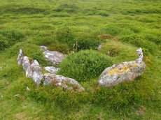
Yar Tor (Money Pit) Platform Cairn Circle and Cist
OS Map: SX 68181 73865
HER: MDV6460
Megalithic Portal: 1369
PMD: Money Pit
Alternate name: Money Pit Platform Cairn Circle and Cist
ShortName: CT Money Pit
Butler map: 14.11
Butler Vol 5: p.23 & Fig.4
DPD page: 122
Grinsell: WID 21
Turner: E51
Barrow Report: 56 62
Notes: "The south cairn is a very spread and slight earthwork with a centrally placed cist. Only the north and west side slabs of the cist remain in situ though a misplaced slab lies to one side of the chamber. Eleven slabs forming a kerb of approximately 3m surrounding the cist remain in situ. Several additional stones survive, protruding just above the surface of the flattened cairn, which are likely to be evidence of an outer circle with a diameter of approximately 11m". Lethbridge diagram p.122 and photo bottom p.122. Butler Money Pit - Vol. 1. Map 14.11 (photo on p.92, diagram pp.125-6).
Nearby sites: SX 68181 73865
Distance: 2.02km
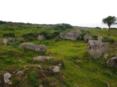
Yar Tor Prehistoric Homestead Round House
OS Map: SX 674 734
HER: MDV26473
Megalithic Portal: 22983
ShortName: HC:YarTor
Nearby sites: SX 674 734
Distance: 2.91km
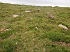
Yar Tor Summit Cairn
OS Map: SX 67865 73943
HER: MDV6434
Megalithic Portal: 11065
Alternate name: Yar Tor summit Cairn
ShortName: CN:Yar Tor Sum
Butler map: 14.8
Grinsell: WID 20
Barrow Report: 56
Notes: "Large cairn (approximately 18.0 metres) built on the summit of Yar Tor; the stones have been rearranged to form a shelter. This cairn is aligned with a reave; part of the Dartmeet parallel reave system."
Nearby sites: SX 67865 73943
Distance: 2.21km