
Prehistoric sites within 2km of SX 69300 79200
Guidance for walkers: The monuments featured in this database are archaeological treasures and need to be protected and preserved - please do not disturb any sites. Please check access and firing times before visiting sites, not all sites listed are on open access land. Firing ranges and boundaries of open access areas are marked on the OL28 OS Dartmoor Explorer map. Please stick to the country code and consider giving support to the numerous agencies that help to keep Dartmoor a fabulous natural and historic environment!
About the database listings: In all listings clicking on the photo or the site name will open a page for the site with a larger photo and further details from the database. The database now has over 6680 records covering nearly all publicly listed sites on Dartmoor including around 4800 round houses. This level of detail is of interest to archaeologists but tends to swamp listings of sites more likely to be of interest for walkers. For this reason, the listings default to around 550 core sites only. These are the stone circles, stone rows and the ring cairns listed by Turner. The default search radius is 2 km. The controls below the map can be used to start a new search by entering a 6- or 8-digit reference (without the prefix "SX"). The search radius can be specified and you can add incremental Display layers of detail on top of the core sites. If using a more detailed layer you will need to decrease the search radius to avoid getting hundreds of search results.
- Core sites Default listing of core sites consisting of stone circles & rows and some of the major ring cairns.
- Plus cairns adds approx. 1000 cairns and other minor sites not included in the core listings but excluding round houses.
- Plus round houses adds approx. 4800 round houses.
- Plus non-sites adds in the records for sites that no longer exist or are not prehistoric sites.
- Plus duplicates adds records excluded as duplicates. Those maybe duplicate records in external listings (e.g. the Historic Environment Records). For example, some sites have been identified as cairns in some listings and interpreted as round houses in other listings and both records appear.
These listings have incorporated, matched up and merged all of the records from all of the major archaeological listings including: Worth, Grinsell, Turner, Butler, Bill Radcliffe, Sandy Gerrard, Megalithic Portal, the National Monument Records and the Historic Environment Records. The author would like to thank Bill, Sandy, the lovely people both at Megalithic Portal (especially Anne Tate who did an amazing job to link listings) and at ACE Archaeology for collaborative work over the years to synchronise and correct listings across the various websites which now interlink. A culmination of years of work the final merger of cairn records took 3 months of cross referencing in 2017 the result being a snapshot of the records at that time. This data has in turn been refined since by field work and research. The round house data was supplied by Sandy Gerrard. Grid references are in order of accuracy: from Google Earth satellite, if visible and found, from a Garmin GPS reading, if visited by the author and from the literature otherwise. Individual site pages will state the source of the grid reference and provide satellite imagery. If a site listing lacks a photo it has not yet been visited by the author in which case the grid reference is from the literature.
Currently the database only includes sites which can be represented by a grid reference. Reaves are not included as they require GIS shape technology which is beyond the current capability of this system. To see the sources for the records, look at the tables on the resources menu. The database listings can also be viewed on a Google map and downloaded as GPS datasets for Garmin devices.
Corrections, or any feedback or suggestions are very welcome, email: info@dartmoorwalks.org.uk.
NOTE: Clicking on the icons for each monument in the map will give the name of the site. You can zoom in and out and drag the map around.
List of sites within 2km of SX 69300 79200
Blackaton Down N. Cairn
OS Map: SX 70683 79094
HER: MDV7413
Megalithic Portal: 16633
ShortName: CN Blackaton N
Butler map: 20.12.1
Butler Vol 5: p.193 & Fig.137
Grinsell: WID 4
Notes: The earthwork remains of two Bronze Age cairns. 'B' is a cairn 42 feet in diameter and 3 feet high. Cairn with small hollow towards centre. Butler Volume 1 Map 20.12.
Nearby sites: SX 70683 79094
Distance: 1.39km
Blackaton Down S. Cairn
OS Map: SX 70732 79047
HER: MDV7412
Megalithic Portal: 16634
ShortName: CN:Blackaton S
Butler map: 20.12.2
Butler Vol 5: p.192 & Fig.136
Grinsell: WID 5
Notes: ['A' SX 7073 7904]. Tumuli on saddle, 'A' is 40 feet in diameter with a rim 1 ft. high. One of pair of cairns, this one is concave or "saucer" shaped. Butler Volume 1 Map 20.12.
Nearby sites: SX 70732 79047
Distance: 1.44km
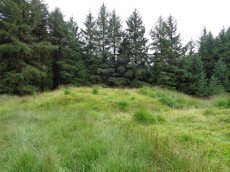
Blackaton Newtake (Hameldown) Ancient Pool
OS Map: SX 70785 78973
HER: MDV7527
ShortName: PO:Hameldown
Notes: Previously recorded as a possible cairn (was listed here as Hameldown 2 Reported Cairn), although identification noted later as 'doubtful' - water filled depression with a few surface stones. Identified as one of the 40+ 'sacred pool' sites on the moor, possibly dating from the Prehistoric period.
Nearby sites: SX 70785 78973
Distance: 1.50km
Broad Barrow Stone Ring Cairn Circle
OS Map: SX 70577 79908
HER: MDV20787
Megalithic Portal: 16630
Alternate name: Broad Burrow Stone Ring Cairn Circle
ShortName: RC BroadBarrow
Butler map: 20.9
Butler Vol 5: p.166 & Fig.106
Grinsell: MAN 10
Turner: A46
Notes: "Infilled ring cairn. Stone ring 14 metres diameter internally with bank 2.5 metres wide and 0.4 metres high. Infilled to 0.25 metres below bank top." Butler Volume 1 Map 20.9.
Nearby sites: SX 70577 79908
Distance: 1.46km
Challacombe Down Cairn Circle
Prehistoric Dartmoor Walks: Dartmoor Site: Challacombe Down Triple Stone Row
OS Map: SX 6898 8084
HER: MDV49462
Megalithic Portal: 1819
PMD: Challacombe Down Stone Row
ShortName: CC Challacombe
Butler map: 24.3
Butler Vol 5: p.239 & Fig.169
Turner: G20
Notes: Dubious site - the current arrangement relates to stones placed during restoration of the stone row. See Worth (1953) p. 226 on how "nothing coherent" came of attempts to re-erect stones scattered to the west of the north end of the row which gave the appearance of a stone circle.
Nearby sites: SX 6898 8084
Distance: 1.67km
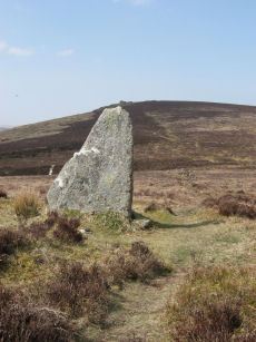
Challacombe Down Standing Stone
Prehistoric Dartmoor Walks: Dartmoor Site: Challacombe Down Triple Stone Row
OS Map: SX 69021 80723
HER: MDV6600
Megalithic Portal: 10092
PMD: Challacombe Stone Row
ShortName: SS Challacombe
Butler map: 24.3
DPD page: 126
Notes: The largest and most prominent blocking stone of the Dartmoor rows is to be found at the Challacombe triple row. Worth states that it is over 5 feet in width at the base and over 6 feet in height. Butler (Vol. 2) states that the terminal pillar is today 0.5m shorter than when it was measured in 1893.
Nearby sites: SX 69021 80723
Distance: 1.55km
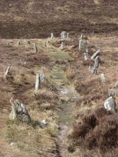
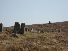
Challacombe Down Stone Row
Prehistoric Dartmoor Walks: Dartmoor Site: Challacombe Down Triple Stone Row
OS Map: SX 69016 80718
HER: MDV6600
Megalithic Portal: 1819
The Stone Rows of GB: Challacombe Down
PMD: Challacombe Stone Row
ShortName: SR Challacombe
Butler map: 24.3
Butler Vol 5: p.239 & Fig.169
DPD page: 126
Notes: "Bronze Age triple stone row well marked and wider apart at the north, drawing nearer to the south where they meet a blocking stone of unusual size. The stones have suffered little in their restoration except that a stone in the middle row was turned to form a blocking stone for that row. The loose stones scattered to the west of the north end have been suggested to form a stone circle and additional rows but may be stones excavated from the north end of the stone row." Breton p.41-42
Nearby sites: SX 69016 80718
Distance: 1.54km
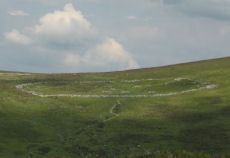
Grimspound Enclosed Settlement
Prehistoric Dartmoor Walks: Dartmoor Site: Grimspound Enclosed Settlement
OS Map: SX 70073 80909
HER: MDV8778
Megalithic Portal: 1344141065
ShortName: ES Grimspound
DPD page: 127
Notes: Probabaly the best known enclosed settlement on Dartmoor, within walking distance of Warren House Inn. "Prehistoric enclosed settlement with a substantial granite surrounding wall, containing 24 hut circles, as well as several 'pens' built into the enclosure wall, positioned in a valley between Hookney Tor and Hameldon. First planned by A. C. Shillibeer in 1829, this site was excavated by the Dartmoor Exploration Committee in 1894-5. Within the guardianship area managed by Dartmoor National Park Authority". Extensive notes on the HER record, see also coverage on Wikipedia and Legendary Dartmoor.
Nearby sites: SX 70073 80909
Distance: 1.88km
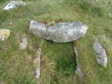
Hameldon Cist
OS Map: SX 71008 78345
HER: MDV7519
Megalithic Portal: 16636
PMD: Hamel Down S.
Alternate name: Hamel Down S. Cist
ShortName: CT Hameldon
Butler map: 20.15
Butler Vol 5: p.178 & Fig.120
DPD page: 129
Grinsell: WID 7
Barrow Report: 54
Notes: Precise location originally unsurveyed but given approximately by Worth as SX 71257908. This may explain the large discrepancy between the NMR position and that given by Butler and in the HER. Three sides of the cist are visible with the fourth having sunken below the earth. The capstone is incomplete and only partly covers the cavity. Lethbridge diagram p129 and photo top p.129. Butler Hamel Down 15 (S) - Vol. 1. Map 20.15 (Cairn 15 p.149, diagram Vol 5. p.178).
Nearby sites: SX 71008 78345
Distance: 1.91km
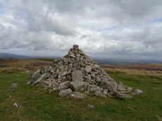
Hameldown Beacon Cairn
OS Map: SX 70830 78922
HER: MDV7435
Megalithic Portal: 16635
Alternate name: Hamel Down Beacon Cairn
ShortName: CN HamelBeacon
Butler map: 20.13
Butler Vol 5: p.166 & Fig.106
Grinsell: WID 6
Notes: A grass covered cairn which was alleged to have been used as a beacon in medieval period. Butler Volume 1 Map 20.13
Nearby sites: SX 70830 78922
Distance: 1.56km
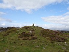
Hameldown Tor Cairn
OS Map: SX 70318 80574
HER: MDV8768
Megalithic Portal: 16628
ShortName: CN HameldonTor
Butler map: 20.8
Butler Vol 5: p.166 & Fig.106
Grinsell: MAN 2
Turner: E54
Notes: Cairn on hameldown tor.(diam 14m. Heig 700mm)a denuded cairn with kerb of large stones on northern half only. Pillar and conical mound of small stones of evidently modern date. Remainder of kerb visible (11 stones). Remainder of cairn largely grassed over but head sized granite boulders visible (os trig. Point and recent mound of stones on top). Butler Volume 1 Map 20.8.
Nearby sites: SX 70318 80574
Distance: 1.71km
Red Barrows Cairn
Prehistoric Dartmoor Walks: Dartmoor Site: Soussons Cairn Circle
OS Map: SX 67718 79650
HER: MDV6007
Megalithic Portal: 34986
PMD: Red Barrows
Alternate name: Red Barrows 1 Cairn
ShortName: CN RedBar 1
Butler map: 24.2.1
Grinsell: MAN 5
Notes: Four Bronze Age round barrows between 10 and 20 meters in diameter and 0.5 to 2.2 meters high. One barrow was excavated in 1902, finds included pottery and flints. See also HER records, 6004, 6005, 6006, 6007.
Nearby sites: SX 67718 79650
Distance: 1.64km

Single Barrow Cairn
OS Map: SX 70576 79538
HER: MDV7487
Megalithic Portal: 16631
ShortName: CN SingleBarro
Butler map: 20.10
Butler Vol 5: p.23 & Fig.106
Grinsell: MAN 11
Notes: Round barrow, crowned by boundary stone dated 1854, and inscribed single burrow. Excavated 1873. Diameter 23 metres, height 1.0 metres. Butler Volume 1 Map 20.10.
Nearby sites: SX 70576 79538
Distance: 1.32km
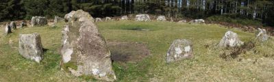
Soussons Common Ring Setting Cairn and Cist
Prehistoric Dartmoor Walks: Dartmoor Site: Soussons Cairn Circle
OS Map: SX 67516 78700
HER: MDV6013
Megalithic Portal: 1266
PMD: Soussons Plantation
Alternate name: Soussons Plantation S. Ring Setting Cairn and Cist
ShortName: CT Soussons Cm
Butler map: 24.2.6
DPD page: 124
Grinsell: MAN 9
Turner: D2
Barrow Report: 22 23 45 56
Notes: "A 28 feet diameter cairn circle with a central cist (plan). The tallest stone in the cairn circle is about 2 feet high." "This cist measures at least 1.3 metres long by 0.5 metres wide and when excavated in 1903 two coils of human hair were found". Lethbridge p.124. Butler Soussons Plantation S - Vol. 2. Map 24.2.6 (diagrams pp. 18-20). Breton p.41.
Nearby sites: SX 67516 78700
Distance: 1.85km
Soussons Down (Red Barrows) Stone Row
Prehistoric Dartmoor Walks: Dartmoor Site: Soussons Cairn Circle
OS Map: SX 6767 7998
HER: MDV6015
Megalithic Portal: 2136
The Stone Rows of GB: Soussons Down
PMD: Red Barrows Stone Row
Alternate name: Soussons Down Stone Row
ShortName: SR Red Barrows
Butler map: 24.2
Notes: Triple row destroyed in 1946 Butler Vol. 5 p38, Vol. 2 Map 24.2 p.19. The row was associated with a cairn about 300m north of the four Red Barrow cairn group (SX 67 NE 3). Butler mentions that some of the stones of the row remained and these were observed and reported to Sandy Gerrard by Chris Jenkins.
Nearby sites: SX 6767 7998
Distance: 1.81km
Two Barrows Stone Ring Cairn Circle
OS Map: SX 70654 79219
HER: MDV7409
Megalithic Portal: 16632
Alternate name: Two Barrows 1 Stone Ring Cairn Circle
ShortName: RC TwoBarrows1
Butler map: 20.11.1
Butler Vol 5: p.23 & Fig.106
Grinsell: MAN 12
Barrow Report: 21 56
Notes: "The northern barrow was excavated in 1872. It measures 40 feet in diameter and 4 1/2 feet high. A ring of stones encircled the barrow and in the centre was a small cairn. A cremation burial was found to the SE of the centre covered by five flat stones. With the cremation was the blade of a bronze dagger and a pommel made from amber with a decoration consisting of rows of gold pins" See: Bate, C Spence, Researches into Some Antient Tumuli on Dartmoor, T.D.A. Vol. 5 pp.549-58 (1872). Relevant Butler map Vol. 1. Map 20. Butler Volume 1 Map 20.11 Two Barrows 1. [N.b. Treated as Turner type Stone Ring Cairn circle from the description].
Nearby sites: SX 70654 79219
Distance: 1.35km
Two Barrows S Cairn
OS Map: SX 70663 79203
HER: MDV7411
Megalithic Portal: 16632
Alternate name: Two Barrows 2 Cairn
ShortName: CN TwoBarrows2
Butler map: 20.11.2
Butler Vol 5: p.23 & Fig.106
Grinsell: WID 3
Notes: Two Barrows 2. An oval, stony mound measuring 15.5m E-W and 10.5m N-S. It stands up to 1.1m high and was probably originally bowl-profiled. The N slope is spit by a narrow path and a N-S slope across the top of the barrow has caused minor damage. It appears to be unexcavated. The mound is crossed by a maintained drystone field wall, approaching from the SE and turning W on the barrow. The wall is built over the mound and does not seem to have caused much damage. This barrow appears to have been a target point for a reave, Fleming's Hameldon South, approaching from the E and stopping 3.5m short of the mound. The reave line is continued W by the modern wall beyond the barrow.
Nearby sites: SX 70663 79203
Distance: 1.36km