
Prehistoric sites within 2km of SX 68400 72500
Guidance for walkers: The monuments featured in this database are archaeological treasures and need to be protected and preserved - please do not disturb any sites. Please check access and firing times before visiting sites, not all sites listed are on open access land. Firing ranges and boundaries of open access areas are marked on the OL28 OS Dartmoor Explorer map. Please stick to the country code and consider giving support to the numerous agencies that help to keep Dartmoor a fabulous natural and historic environment!
About the database listings: In all listings clicking on the photo or the site name will open a page for the site with a larger photo and further details from the database. The database now has over 6680 records covering nearly all publicly listed sites on Dartmoor including around 4800 round houses. This level of detail is of interest to archaeologists but tends to swamp listings of sites more likely to be of interest for walkers. For this reason, the listings default to around 550 core sites only. These are the stone circles, stone rows and the ring cairns listed by Turner. The default search radius is 2 km. The controls below the map can be used to start a new search by entering a 6- or 8-digit reference (without the prefix "SX"). The search radius can be specified and you can add incremental Display layers of detail on top of the core sites. If using a more detailed layer you will need to decrease the search radius to avoid getting hundreds of search results.
- Core sites Default listing of core sites consisting of stone circles & rows and some of the major ring cairns.
- Plus cairns adds approx. 1000 cairns and other minor sites not included in the core listings but excluding round houses.
- Plus round houses adds approx. 4800 round houses.
- Plus non-sites adds in the records for sites that no longer exist or are not prehistoric sites.
- Plus duplicates adds records excluded as duplicates. Those maybe duplicate records in external listings (e.g. the Historic Environment Records). For example, some sites have been identified as cairns in some listings and interpreted as round houses in other listings and both records appear.
These listings have incorporated, matched up and merged all of the records from all of the major archaeological listings including: Worth, Grinsell, Turner, Butler, Bill Radcliffe, Sandy Gerrard, Megalithic Portal, the National Monument Records and the Historic Environment Records. The author would like to thank Bill, Sandy, the lovely people both at Megalithic Portal (especially Anne Tate who did an amazing job to link listings) and at ACE Archaeology for collaborative work over the years to synchronise and correct listings across the various websites which now interlink. A culmination of years of work the final merger of cairn records took 3 months of cross referencing in 2017 the result being a snapshot of the records at that time. This data has in turn been refined since by field work and research. The round house data was supplied by Sandy Gerrard. Grid references are in order of accuracy: from Google Earth satellite, if visible and found, from a Garmin GPS reading, if visited by the author and from the literature otherwise. Individual site pages will state the source of the grid reference and provide satellite imagery. If a site listing lacks a photo it has not yet been visited by the author in which case the grid reference is from the literature.
Currently the database only includes sites which can be represented by a grid reference. Reaves are not included as they require GIS shape technology which is beyond the current capability of this system. To see the sources for the records, look at the tables on the resources menu. The database listings can also be viewed on a Google map and downloaded as GPS datasets for Garmin devices.
Corrections, or any feedback or suggestions are very welcome, email: info@dartmoorwalks.org.uk.
NOTE: Clicking on the icons for each monument in the map will give the name of the site. You can zoom in and out and drag the map around.
List of sites within 2km of SX 68400 72500
Aller Brook E. (duplicate) Cist
OS Map: SX 67813 71682
HER: MDV20166
Megalithic Portal: 45799
PMD: Aller Brook E.
ShortName: CT Aller BrkE2
Butler map: 60.11
DPD page: 90
Notes: Butler Vol. 4. Map 60.11 (diagram p.181). only the four sides of the cist remain (1.0 x 0.5m), orientated WNW. Around it are two or three flat slabs of the retaining circle but the cover stone has gone as have all traces of the mound Lethbridge diagram and photo bottom left p.90
NB. The HER entry MDV126409 is duplicated with MDV20166 - see also SiteID=444
Nearby sites: SX 67813 71682
Distance: 1.01km
Yar Tor Tor Enclosure
OS Map: SX 67849 74046
HER: MDV128748
ShortName: EN Yar Tor
Butler map: 14.8
Notes: HER quoting Newman: A Tor enclosure of uncertain date on the northern outcrop of Yar Tor. This enclosure is situated in a natural avenue between two outcrops with vertical faces on the north and south sides which has been blocked off at the western and eastern ends by artificial stone walls.
Nearby sites: SX 67849 74046
Distance: 1.64km

Corndon Tor 1 Cairn
OS Map: SX 68588 74227
HER: MDV6387
Megalithic Portal: 22982
ShortName: CN CorndonTor
Butler map: 15.4.1
Barrow Report: 56 62
Notes: HER: Cairn on the summit of Corndon Tor, to the north of the main outcrop, comprising a large stony mound, constructed from moorstone with a truncated cone profile and no turf cover. Remains of a possible second cairn are located to the south on the outcrop.
Nearby sites: SX 68588 74227
Distance: 1.74km
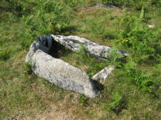
Aller Brook E Cist
OS Map: SX 67813 71682
HER: MDV126409
Megalithic Portal: 45799
PMD: Aller Brook E.
Alternate name: Aller Brook E. Cist
ShortName: CT Aller Brk E
Butler map: 60.11
DPD page: 90
Notes: Butler Vol. 4. Map 60.11 (diagram p.181). only the four sides of the cist remain (1.0 x 0.5m), orientated WNW. Around it are two or three flat slabs of the retaining circle but the cover stone has gone as have all traces of the mound Lethbridge diagram and photo bottom left p.90.
NB. The HER entry MDV126409 is duplicated with MDV20166 - see also SiteID=1842
Nearby sites: SX 67813 71682
Distance: 1.01km
Holne Moor Stone Row
OS Map: SX 67431 71042
HER: MDV12983
Megalithic Portal: 1981
The Stone Rows of GB: Holne Moor
PMD: Holne Moor Stone Row
ShortName: SR Holne Moor
Butler map: 60.25
DPD page: 90
Notes: "A standing stone and triple stone row lying in a secluded position, across the head of a shallow, north facing valley. It measures 147 metres long with rows on average 1.5 m apart. The stones, fifty three of which were located, have a maximum height of 0.2 m and are spaced about 1.1 m apart, each opposite the stone of the adjacent row. There is also a possible former standing stone which is now recumbent." See also MDV129985
Nearby sites: SX 67431 71042
Distance: 1.75km
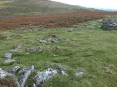
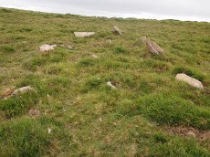
Holne Moor (N) Stone Ring Cairn Circle
OS Map: SX 6809 7162
HER: MDV26266
Megalithic Portal: 45830
ShortName: RC:HolneMoor N
Turner: A16
Notes: "Possible cairn in corner of a field." "Stone ring 9.5m diam internally, with bank 1.2m wide and 0.4m high. Joined on w side by reave (turner)." No NMR record.
Nearby sites: SX 6809 7162
Distance: 0.93km
Horns Cross N. Cairn
OS Map: SX 66941 71187
HER: MDV26276
Megalithic Portal: 27342
Alternate name: Holne Ridge N.5 Cairn
ShortName: CN HolneRidg 5
Butler map: 60.26.5
Grinsell: HOL 2
Notes: "A turf and bracken covered Bronze Age cairn forming part of a cairn cemetery on Holne Ridge. The mound measures 14 metres by 14.4 metres in diameter and standing to a height of 1.4 metres. " Butler cairn 5 map 60.15. UPDATE 03/01/2023 This record formerly linked with MDV12975 which has been deleted.
It is unclear but this record now realte to MDV26276 which is a "tin-working spoil dump".
Nearby sites: SX 66941 71187
Distance: 1.96km
Yar Tor Stone Row
OS Map: SX 68177 73857
HER: MDV6459
Megalithic Portal: 2199
The Stone Rows of GB: Yar Tor
PMD: Yar Tor Stone Row
ShortName: SR Yar Tor
Butler map: 14.11
DPD page: 122
Barrow Report: 56
Notes: "The remains of a probable triple stone row with a cairn and cist at its south end and a barrow at its north. The row comprises stones set 2m apart and standing to a height of 0.3m. Some are concealed beneath the turf. The cairn measures 11m in diameter and 0.3m high with a central cist surrounded by a kerb. The barrow is 6m in diameter and 1m high".
Nearby sites: SX 68177 73857
Distance: 1.38km

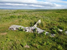
Yar Tor (Money Pit) Platform Cairn Circle and Cist
OS Map: SX 68181 73865
HER: MDV6460
Megalithic Portal: 1369
PMD: Money Pit
Alternate name: Money Pit Platform Cairn Circle and Cist
ShortName: CT Money Pit
Butler map: 14.11
Butler Vol 5: p.23 & Fig.4
DPD page: 122
Grinsell: WID 21
Turner: E51
Barrow Report: 56 62
Notes: "The south cairn is a very spread and slight earthwork with a centrally placed cist. Only the north and west side slabs of the cist remain in situ though a misplaced slab lies to one side of the chamber. Eleven slabs forming a kerb of approximately 3m surrounding the cist remain in situ. Several additional stones survive, protruding just above the surface of the flattened cairn, which are likely to be evidence of an outer circle with a diameter of approximately 11m". Lethbridge diagram p.122 and photo bottom p.122. Butler Money Pit - Vol. 1. Map 14.11 (photo on p.92, diagram pp.125-6).
Nearby sites: SX 68181 73865
Distance: 1.38km
Yar Tor Prehistoric Homestead Round House
OS Map: SX 674 734
HER: MDV26473
Megalithic Portal: 22983
ShortName: HC:YarTor
Notes: HER: Two incomplete conjoined enclosures on the south-west slope of Yar Tor, near Dartmeet, of probable Medieval date.
Nearby sites: SX 674 734
Distance: 1.35km

Yar Tor Summit Cairn
OS Map: SX 67865 73943
HER: MDV6434
Megalithic Portal: 11065
Alternate name: Yar Tor summit Cairn
ShortName: CN Yar Tor Sum
Butler map: 14.8
Grinsell: WID 20
Barrow Report: 56
Notes: "Large cairn (approximately 18.0 metres) built on the summit of Yar Tor; the stones have been rearranged to form a shelter. This cairn is aligned with a reave; part of the Dartmeet parallel reave system."
Nearby sites: SX 67865 73943
Distance: 1.54km