
Prehistoric sites within 3km of SX 63200 83600
Guidance for walkers: The monuments featured in this database are archaeological treasures and need to be protected and preserved - please do not disturb any sites. Please check access and firing times before visiting sites, not all sites listed are on open access land. Firing ranges and boundaries of open access areas are marked on the OL28 OS Dartmoor Explorer map. Please stick to the country code and consider giving support to the numerous agencies that help to keep Dartmoor a fabulous natural and historic environment!
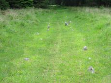
About the database listings: In all listings clicking on the photo or the site name will open a page for the site with a larger photo and further details from the database. The database now has over 6680 records covering nearly all publicly listed sites on Dartmoor including around 4800 round houses. This level of detail is of interest to archaeologists but tends to swamp listings of sites more likely to be of interest for walkers. For this reason, the listings default to around 550 core sites only. These are the stone circles, stone rows and the ring cairns listed by Turner. The default search radius is 2 km. The controls below the map can be used to start a new search by entering a 6- or 8-digit reference (without the prefix "SX"). The search radius can be specified and you can add incremental Display layers of detail on top of the core sites. If using a more detailed layer you will need to decrease the search radius to avoid getting hundreds of search results.
- Core sites Default listing of core sites consisting of stone circles & rows and some of the major ring cairns.
- Plus cairns adds approx. 1000 cairns and other minor sites not included in the core listings but excluding round houses.
- Plus round houses adds approx. 4800 round houses.
- Plus non-sites adds in the records for sites that no longer exist or are not prehistoric sites.
- Plus duplicates adds records excluded as duplicates. Those maybe duplicate records in external listings (e.g. the Historic Environment Records). For example, some sites have been identified as cairns in some listings and interpreted as round houses in other listings and both records appear.
These listings have incorporated, matched up and merged all of the records from all of the major archaeological listings including: Worth, Grinsell, Turner, Butler, Bill Radcliffe, Sandy Gerrard, Megalithic Portal, the National Monument Records and the Historic Environment Records. The author would like to thank Bill, Sandy, the lovely people both at Megalithic Portal (especially Anne Tate who did an amazing job to link listings) and at ACE Archaeology for collaborative work over the years to synchronise and correct listings across the various websites which now interlink. A culmination of years of work the final merger of cairn records took 3 months of cross referencing in 2017 the result being a snapshot of the records at that time. This data has in turn been refined since by field work and research. The round house data was supplied by Sandy Gerrard. Grid references are in order of accuracy: from Google Earth satellite, if visible and found, from a Garmin GPS reading, if visited by the author and from the literature otherwise. Individual site pages will state the source of the grid reference and provide satellite imagery. If a site listing lacks a photo it has not yet been visited by the author in which case the grid reference is from the literature.
Currently the database only includes sites which can be represented by a grid reference. Reaves are not included as they require GIS shape technology which is beyond the current capability of this system. To see the sources for the records, look at the tables on the resources menu. The database listings can also be viewed on a Google map and downloaded as GPS datasets for Garmin devices.
Corrections, or any feedback or suggestions are very welcome, email: info@dartmoorwalks.org.uk.
NOTE: Clicking on the icons for each monument in the map will give the name of the site. You can zoom in and out and drag the map around.
List of sites within 3km of SX 63200 83600
Stannon Newtake a Reported Cist
OS Map: SX 6492 8123
HER: MDV19547
PMD: Stannon Newtake a
ShortName: CN:Stannon N2
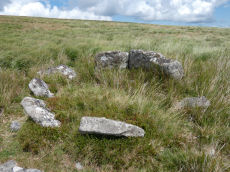
Notes: Four upright slabs form a crude semi-circle on a small shelf of an otherwise steep, e-facing and clitter strewn hillside, above stannon brook. The semi-circle described by the slabs is 3m in diam with a max height of 0.7m. It does not form a recognisable archaeological feature and seems more like random assemblage of natural slabs
Nearby sites: SX 6492 8123
Distance: 2.93km
Stannon Newtake b Cairn
OS Map: SX 6518 8149
HER: MDV15378
PMD: Stannon Newtake b
ShortName: CN:Stannon N3
Notes: (greeves + robinson) prehistoric long cairn 16m long, 6.50m width (max), 1m high (highest at ne end). Small rectangular depression in ne end and stone slab set on edge at sw end. Composed mostly of small stone, covered with gorse and is disturbed by track at sw end
Nearby sites: SX 6518 8149
Distance: 2.89km
Manga Brook Crop Mark
OS Map: SX 6305 8478
HER: MDV27298
ShortName: CN?Manga Brook
Notes: Aerial Photograph
Nearby sites: SX 6305 8478
Distance: 1.19km
Lowton Brook Round House
OS Map: SX 66155 83539
HER: MDV105624
ShortName: HT:Lowton Br13
Nearby sites: SX 66155 83539
Distance: 2.96km
White Ridge N Round House
OS Map: SX 64677 82890
HER: MDV59423
ShortName: HT:White Rid1
Nearby sites: SX 64677 82890
Distance: 1.64km
White Ridge N Round House
OS Map: SX 64645 82857
HER: MDV59421
ShortName: HT:White Rid2
Nearby sites: SX 64645 82857
Distance: 1.62km
White Ridge N Round House
OS Map: SX 64627 82913
HER: MDV59422
ShortName: HT:White Rid3
Nearby sites: SX 64627 82913
Distance: 1.58km
White Ridge N Round House
OS Map: SX 64685 82872
HER: MDV59424
ShortName: HT:White Rid4
Nearby sites: SX 64685 82872
Distance: 1.65km
Shovel Down Round House
OS Map: SX 65247 85755
HER: MDV58334
ShortName: HT:Shovel Do4
Nearby sites: SX 65247 85755
Distance: 2.97km
White Ridge S Round House
OS Map: SX 64696 81605
HER: MDV59433
ShortName: HT:White Rid5
Nearby sites: SX 64696 81605
Distance: 2.49km
White Ridge S Round House
OS Map: SX 64788 81709
HER: MDV59428
ShortName: HT:White Rid6
Nearby sites: SX 64788 81709
Distance: 2.47km
White Ridge S Round House
OS Map: SX 64805 81762
HER: MDV59432
ShortName: HT:White Rid7
Nearby sites: SX 64805 81762
Distance: 2.44km
White Ridge S Round House
OS Map: SX 64828 81732
HER: MDV59430
ShortName: HT:White Rid8
Nearby sites: SX 64828 81732
Distance: 2.48km
White Ridge S Round House
OS Map: SX 64638 81559
HER: MDV59434
ShortName: HT:White Rid9
Nearby sites: SX 64638 81559
Distance: 2.50km
White Ridge W Round House
OS Map: SX 64275 81818
HER: MDV6748
ShortName: HT:White Rid10
Nearby sites: SX 64275 81818
Distance: 2.08km
White Ridge W Round House
OS Map: SX 64396 81562
HER: MDV59425
ShortName: HT:White Rid11
Nearby sites: SX 64396 81562
Distance: 2.36km
Manga Rock SE Round House
OS Map: SX 63853 85596
HER: MDV54484
ShortName: HT:Manga Roc1
Nearby sites: SX 63853 85596
Distance: 2.10km
White Ridge W Round House
OS Map: SX 64296 81879
HER: MDV6748
ShortName: HT:White Rid12
Nearby sites: SX 64296 81879
Distance: 2.04km
Manga Rock SE Round House
OS Map: SX 63846 85602
HER: MDV54485
ShortName: HT:Manga Roc2
Nearby sites: SX 63846 85602
Distance: 2.10km
White Ridge W Round House
OS Map: SX 64388 81561
HER: MDV59426
ShortName: HT:White Rid13
Nearby sites: SX 64388 81561
Distance: 2.36km
Manga Rock SE Round House
OS Map: SX 63837 85594
HER: MDV54483
ShortName: HT:Manga Roc3
Nearby sites: SX 63837 85594
Distance: 2.09km
White Ridge W Round House
OS Map: SX 64248 81808
HER: MDV6748
ShortName: HT:White Rid14
Nearby sites: SX 64248 81808
Distance: 2.08km
Shoveldown N.W.7 Cairn
OS Map: SX 6423 8622
HER: MDV37096
ShortName: CN:Shovel NW7
Nearby sites: SX 6423 8622
Distance: 2.82km
White Ridge W Round House
OS Map: SX 64357 81800
HER: MDV6748
ShortName: HT:White Rid15
Nearby sites: SX 64357 81800
Distance: 2.14km
White Ridge W Round House
OS Map: SX 64353 81607
HER: MDV59427
ShortName: HT:White Rid16
Nearby sites: SX 64353 81607
Distance: 2.30km
White Ridge W Round House
OS Map: SX 64239 81665
HER: MDV6775
ShortName: HT:White Rid17
Nearby sites: SX 64239 81665
Distance: 2.20km
White Ridge W Round House
OS Map: SX 6394 8150
HER: MDV54689
ShortName: HT:White Rid18
Nearby sites: SX 6394 8150
Distance: 2.23km
White Ridge W Round House
OS Map: SX 64266 81830
HER: MDV6748
ShortName: HT:White Rid19
Nearby sites: SX 64266 81830
Distance: 2.07km
Hemstone Rocks Round House
OS Map: SX 64789 83812
HER: MDV6733
ShortName: HT:Hemstone 1
Nearby sites: SX 64789 83812
Distance: 1.60km
White Ridge W Round House
OS Map: SX 64287 81897
HER: MDV6748
ShortName: HT:White Rid20
Nearby sites: SX 64287 81897
Distance: 2.02km
Hemstone Rocks Round House
OS Map: SX 64742 83700
HER: MDV104643
ShortName: HT:Hemstone 2
Nearby sites: SX 64742 83700
Distance: 1.55km
Hemstone Rocks Round House
OS Map: SX 64803 83768
HER: MDV6734
ShortName: HT:Hemstone 3
Nearby sites: SX 64803 83768
Distance: 1.61km
Hemstone Rocks Round House
OS Map: SX 64811 83776
HER: MDV6735
ShortName: HT:Hemstone 4
Nearby sites: SX 64811 83776
Distance: 1.62km
Hemstone Rocks Round House
OS Map: SX 64816 83786
HER: MDV6736
ShortName: HT:Hemstone 5
Nearby sites: SX 64816 83786
Distance: 1.63km
Watern Tor S. Cairn
OS Map: SX 62912 86086
HER: MDV4376
ShortName: CN:Watern To2
Butler map: 41.3
Grinsell: LYD 8
Notes: "Cairn lies east of Hangingstone Hill. Measures 23 metres in length, 19.5 metres wide and 2.0 metres high."
Nearby sites: SX 62912 86086
Distance: 2.50km
Hemstone Rocks Round House
OS Map: SX 64847 83815
HER: MDV6738
ShortName: HT:Hemstone 6
Nearby sites: SX 64847 83815
Distance: 1.66km
Hemstone Rocks Round House
OS Map: SX 64854 83803
HER: MDV6737
ShortName: HT:Hemstone 7
Nearby sites: SX 64854 83803
Distance: 1.67km
Hemstone Rocks Round House
OS Map: SX 64772 83799
HER: MDV6732
ShortName: HT:Hemstone 8
Nearby sites: SX 64772 83799
Distance: 1.58km
Teignhead Newtake 2 (duplicate) Reported Cairn
OS Map: SX 625 845
HER: MDV54673
ShortName: CN:Teignhead3
Notes: Duplicate of HER 6796
Nearby sites: SX 625 845
Distance: 0.81km
Langridge Newtake Cairn
OS Map: SX 6420 8476
HER: MDV54686
ShortName: CN:Langridge1
Nearby sites: SX 6420 8476
Distance: 1.53km
Shoveldown N.W.8 Cairn
OS Map: SX 6452 8592
HER: MDV58285
ShortName: CN:Shovel NW8
Nearby sites: SX 6452 8592
Distance: 2.67km
Stonetor Hill 2 Cairn
OS Map: SX 6525 8538
HER: MDV58358
ShortName: CN:Stonetor 2
Nearby sites: SX 6525 8538
Distance: 2.71km
Stonetor Hill 2 (duplicate) Reported Cairn
OS Map: SX 6525 8538
HER: MDV58359
ShortName: CN:Stonetor 6
Notes: Duplicate of HER 58358
Nearby sites: SX 6525 8538
Distance: 2.71km
Winney's Down Cairn
OS Map: SX 6362 8182
HER: MDV59463
ShortName: CN:Winney's 1
Nearby sites: SX 6362 8182
Distance: 1.83km
Stonetor Hill Round House
OS Map: SX 65001 85595
HER: MDV58354
ShortName: HT:Stonetor 1
Nearby sites: SX 65001 85595
Distance: 2.69km
Stonetor Hill Round House
OS Map: SX 65019 85598
HER: MDV58355
ShortName: HT:Stonetor 2
Nearby sites: SX 65019 85598
Distance: 2.70km
Stonetor Hill Round House
OS Map: SX 65034 85681
HER: MDV58351
ShortName: HT:Stonetor 3
Nearby sites: SX 65034 85681
Distance: 2.77km
Stonetor Hill Round House
OS Map: SX 65043 85583
HER: MDV58356
ShortName: HT:Stonetor 4
Nearby sites: SX 65043 85583
Distance: 2.71km
Stonetor Hill Round House
OS Map: SX 64987 85651
HER: MDV58353
ShortName: HT:Stonetor 5
Nearby sites: SX 64987 85651
Distance: 2.72km
Stonetor Hill Round House
OS Map: SX 65064 85456
HER: MDV58357
ShortName: HT:Stonetor 6
Nearby sites: SX 65064 85456
Distance: 2.63km
Stonetor Hill Round House
OS Map: SX 65057 85667
HER: MDV58352
ShortName: HT:Stonetor 7
Nearby sites: SX 65057 85667
Distance: 2.78km
Stonetor Hill N Round House
OS Map: SX 64760 86032
HER: MDV4401
ShortName: HT:Stonetor 8
Nearby sites: SX 64760 86032
Distance: 2.89km
Stonetor Hill N Round House
OS Map: SX 64769 86049
HER: MDV4401
ShortName: HT:Stonetor 9
Nearby sites: SX 64769 86049
Distance: 2.91km
Stonetor Hill N Round House
OS Map: SX 64769 86041
HER: MDV4401
ShortName: HT:Stonetor 10
Nearby sites: SX 64769 86041
Distance: 2.90km
Stonetor Hill N Round House
OS Map: SX 64759 86061
HER: MDV4401
ShortName: HT:Stonetor 11
Nearby sites: SX 64759 86061
Distance: 2.91km
Stonetor Hill N Round House
OS Map: SX 64877 85881
HER: MDV54498
ShortName: HT:Stonetor 12
Nearby sites: SX 64877 85881
Distance: 2.83km
Stonetor Hill N Round House
OS Map: SX 64759 86074
HER: MDV4401
ShortName: HT:Stonetor 13
Nearby sites: SX 64759 86074
Distance: 2.92km
Stonetor Hill N Round House
OS Map: SX 64762 86010
HER: MDV4401
ShortName: HT:Stonetor 14
Nearby sites: SX 64762 86010
Distance: 2.87km
Stonetor Hill N Round House
OS Map: SX 6468 8605
HER: MDV4680
ShortName: HT:Stonetor 15
Nearby sites: SX 6468 8605
Distance: 2.86km
Stonetor Hill N Round House
OS Map: SX 64737 86014
HER: MDV4401
ShortName: HT:Stonetor 16
Nearby sites: SX 64737 86014
Distance: 2.86km
Stonetor Hill N Round House
OS Map: SX 646 860
HER: MDV58362
ShortName: HT:Stonetor 17
Nearby sites: SX 646 860
Distance: 2.78km
Stonetor Hill N Round House
OS Map: SX 64735 85978
HER: MDV4401
ShortName: HT:Stonetor 18
Nearby sites: SX 64735 85978
Distance: 2.83km
Stonetor Hill SW Round House
OS Map: SX 64552 85274
ShortName: HT:Stonetor 19
Nearby sites: SX 64552 85274
Distance: 2.15km
Stonetor Hill SW Round House
OS Map: SX 64536 85221
HER: MDV4692
ShortName: HT:Stonetor 20
Nearby sites: SX 64536 85221
Distance: 2.10km
Stonetor Hill SW Round House
OS Map: SX 64644 85204
HER: MDV4699
ShortName: HT:Stonetor 21
Nearby sites: SX 64644 85204
Distance: 2.16km
Stonetor Hill SW Round House
OS Map: SX 64605 85149
HER: MDV58341
ShortName: HT:Stonetor 22
Nearby sites: SX 64605 85149
Distance: 2.09km
Stonetor Hill SW Round House
OS Map: SX 64601 85135
HER: MDV4703
ShortName: HT:Stonetor 23
Nearby sites: SX 64601 85135
Distance: 2.08km
Stonetor Hill SW Round House
OS Map: SX 64584 85215
HER: MDV4693
ShortName: HT:Stonetor 24
Nearby sites: SX 64584 85215
Distance: 2.13km
Stonetor Hill SW Round House
OS Map: SX 64545 85283
ShortName: HT:Stonetor 25
Nearby sites: SX 64545 85283
Distance: 2.15km
Stonetor Hill SW Round House
OS Map: SX 64548 85191
HER: MDV4691
ShortName: HT:Stonetor 26
Nearby sites: SX 64548 85191
Distance: 2.09km
Stonetor Hill SW Round House
OS Map: SX 64576 85247
HER: MDV4690
ShortName: HT:Stonetor 27
Nearby sites: SX 64576 85247
Distance: 2.15km
Stonetor Hill SW Round House
OS Map: SX 64564 85082
HER: MDV58342
ShortName: HT:Stonetor 28
Nearby sites: SX 64564 85082
Distance: 2.01km
Stonetor Hill SW Round House
OS Map: SX 64530 85183
HER: MDV4689
ShortName: HT:Stonetor 29
Nearby sites: SX 64530 85183
Distance: 2.07km
Stonetor Hill SW Round House
OS Map: SX 64401 85267
HER: MDV58347
ShortName: HT:Stonetor 30
Nearby sites: SX 64401 85267
Distance: 2.05km
Stonetor Hill SW Round House
OS Map: SX 64397 85238
HER: MDV58346
ShortName: HT:Stonetor 31
Nearby sites: SX 64397 85238
Distance: 2.03km
Stonetor Hill SW Round House
OS Map: SX 64554 85203
HER: MDV4694
ShortName: HT:Stonetor 32
Nearby sites: SX 64554 85203
Distance: 2.10km
Hangingstone Hill (duplicate 1) Reported Cairn
OS Map: SX 61658 86059
HER: MDV115805
ShortName: CN:Hangingst2
Notes: Duplicate of HER 4377
Nearby sites: SX 61658 86059
Distance: 2.90km
Stonetor Hill SW Round House
OS Map: SX 64551 85066
HER: MDV4705
ShortName: HT:Stonetor 33
Nearby sites: SX 64551 85066
Distance: 1.99km
Hangingstone Hill (duplicate 2) Reported Cairn
OS Map: SX 61929 86139
HER: MDV115806
ShortName: CN:Hangingst3
Notes: Duplicate of HER 4377
Nearby sites: SX 61929 86139
Distance: 2.84km
Stonetor Hill SW Round House
OS Map: SX 64551 85055
HER: MDV4706
ShortName: HT:Stonetor 34
Nearby sites: SX 64551 85055
Distance: 1.99km
Broad Down NE Round House
OS Map: SX 63712 81168
HER: MDV6802
ShortName: HT:Broad Dow2
Nearby sites: SX 63712 81168
Distance: 2.49km
Stonetor Hill SW Round House
OS Map: SX 64498 85018
HER: MDV58345
ShortName: HT:Stonetor 35
Nearby sites: SX 64498 85018
Distance: 1.92km
Broad Down NE Round House
OS Map: SX 63712 81186
HER: MDV6802
ShortName: HT:Broad Dow3
Nearby sites: SX 63712 81186
Distance: 2.47km
Stonetor Hill SW Round House
OS Map: SX 64561 85200
HER: MDV4694
ShortName: HT:Stonetor 36
Nearby sites: SX 64561 85200
Distance: 2.10km
Broad Down NE Round House
OS Map: SX 63717 81193
HER: MDV6802
ShortName: HT:Broad Dow4
Nearby sites: SX 63717 81193
Distance: 2.46km
Stonetor Hill SW Round House
OS Map: SX 64467 85244
HER: MDV4685
ShortName: HT:Stonetor 37
Nearby sites: SX 64467 85244
Distance: 2.08km
Broad Down NE Round House
OS Map: SX 63754 81387
HER: MDV27273
ShortName: HT:Broad Dow5
Nearby sites: SX 63754 81387
Distance: 2.28km
Stonetor Hill SW Round House
OS Map: SX 64357 85292
HER: MDV4399
ShortName: HT:Stonetor 38
Nearby sites: SX 64357 85292
Distance: 2.05km
Stonetor Hill SW Round House
OS Map: SX 64344 85297
HER: MDV4398
ShortName: HT:Stonetor 39
Nearby sites: SX 64344 85297
Distance: 2.05km
Stonetor Hill SW Round House
OS Map: SX 64332 85327
HER: MDV4397
ShortName: HT:Stonetor 40
Nearby sites: SX 64332 85327
Distance: 2.06km
Stonetor Hill SW Round House
OS Map: SX 64561 85208
HER: MDV4694
ShortName: HT:Stonetor 41
Nearby sites: SX 64561 85208
Distance: 2.11km
Stonetor Hill SW Round House
OS Map: SX 64563 85092
HER: MDV58341
ShortName: HT:Stonetor 42
Nearby sites: SX 64563 85092
Distance: 2.02km
Stonetor Hill SW Round House
OS Map: SX 64515 85235
HER: MDV4688
ShortName: HT:Stonetor 43
Nearby sites: SX 64515 85235
Distance: 2.10km
Stonetor Hill SW Round House
OS Map: SX 64508 85183
HER: MDV4696
ShortName: HT:Stonetor 44
Nearby sites: SX 64508 85183
Distance: 2.05km
Stonetor Hill SW Round House
OS Map: SX 64511 85166
HER: MDV4697
ShortName: HT:Stonetor 45
Nearby sites: SX 64511 85166
Distance: 2.04km
Stonetor Hill SW Round House
OS Map: SX 64515 85300
HER: MDV4684
ShortName: HT:Stonetor 46
Nearby sites: SX 64515 85300
Distance: 2.15km
Stonetor Hill SW Round House
OS Map: SX 64477 85247
HER: MDV54493
ShortName: HT:Stonetor 47
Nearby sites: SX 64477 85247
Distance: 2.08km
Stonetor Hill SW Round House
OS Map: SX 64685 85199
HER: MDV58340
ShortName: HT:Stonetor 48
Nearby sites: SX 64685 85199
Distance: 2.18km
Stonetor Hill SW Round House
OS Map: SX 64504 85029
ShortName: HT:Stonetor 49
Nearby sites: SX 64504 85029
Distance: 1.93km
Stonetor Hill SW Round House
OS Map: SX 64485 85227
HER: MDV4687
ShortName: HT:Stonetor 50
Nearby sites: SX 64485 85227
Distance: 2.07km
Stonetor Hill SW Round House
OS Map: SX 64519 85166
HER: MDV4698
ShortName: HT:Stonetor 51
Nearby sites: SX 64519 85166
Distance: 2.05km
Stonetor Hill SW Round House
OS Map: SX 64523 85173
HER: MDV4698
ShortName: HT:Stonetor 52
Nearby sites: SX 64523 85173
Distance: 2.06km
Stonetor Hill SW Round House
OS Map: SX 64496 85290
HER: MDV4683
ShortName: HT:Stonetor 53
Nearby sites: SX 64496 85290
Distance: 2.13km
Stonetor Hill SW Round House
OS Map: SX 64659 85182
HER: MDV4700
ShortName: HT:Stonetor 54
Nearby sites: SX 64659 85182
Distance: 2.15km
Stonetor Hill SW Round House
OS Map: SX 64527 85200
HER: MDV4689
ShortName: HT:Stonetor 55
Nearby sites: SX 64527 85200
Distance: 2.08km
Stonetor Hill SW Round House
OS Map: SX 64500 85166
HER: MDV4695
ShortName: HT:Stonetor 56
Nearby sites: SX 64500 85166
Distance: 2.04km
Stonetor Hill SW Round House
OS Map: SX 64719 85058
HER: MDV4701
ShortName: HT:Stonetor 57
Nearby sites: SX 64719 85058
Distance: 2.11km
Stonetor Hill W Round House
OS Map: SX 6432 8556
HER: MDV58336
ShortName: HT:Stonetor 58
Nearby sites: SX 6432 8556
Distance: 2.26km
Stonetor Hill W Round House
OS Map: SX 6430 8554
HER: MDV54492
ShortName: HT:Stonetor 59
Nearby sites: SX 6430 8554
Distance: 2.23km
Stonetor Hill W Round House
OS Map: SX 6428 8553
HER: MDV58335
ShortName: HT:Stonetor 60
Nearby sites: SX 6428 8553
Distance: 2.21km
Stonetor Hill W Round House
OS Map: SX 6441 8566
HER: MDV54495
ShortName: HT:Stonetor 61
Nearby sites: SX 6441 8566
Distance: 2.39km
Stonetor Hill W Round House
OS Map: SX 6429 8559
HER: MDV58337
ShortName: HT:Stonetor 62
Nearby sites: SX 6429 8559
Distance: 2.27km
Grey Wethers E.2 Cairn
OS Map: SX 64268 83305
HER: MDV20917
ShortName: CN:Grey Weth 2
Notes: large circular prehistoric cairn east of grey wethers. It is visible on the ridge from the stone circle. Possible stony ring bank with central cairn mound or ring. A small conventional cairn lies adjacent to it on its ne side.
Nearby sites: SX 64268 83305
Distance: 1.11km
Grey Wethers E.3 Reported Cairn
OS Map: SX 64401 83398
HER: MDV6766
ShortName: CN?Grey Weth 3
Notes: possible barrow. Vegetation bank shown in dry weather. Approximately 25ft across, 1ft high.
Nearby sites: SX 64401 83398
Distance: 1.22km
Assycombe Round House
OS Map: SX 65957 82762
HER: MDV14807
ShortName: HT:Assycombe1
Nearby sites: SX 65957 82762
Distance: 2.88km
Assycombe Round House
OS Map: SX 65936 82464
HER: MDV14807
ShortName: HT:Assycombe2
Nearby sites: SX 65936 82464
Distance: 2.96km
Assycombe Round House
OS Map: SX 65909 82687
HER: MDV14807
ShortName: HT:Assycombe3
Nearby sites: SX 65909 82687
Distance: 2.86km
Assycombe Round House
OS Map: SX 65906 82863
HER: MDV14807
ShortName: HT:Assycombe5
Nearby sites: SX 65906 82863
Distance: 2.80km
Assycombe Round House
OS Map: SX 65905 82852
HER: MDV14807
ShortName: HT:Assycombe6
Nearby sites: SX 65905 82852
Distance: 2.81km
Assycombe Round House
OS Map: SX 66018 82593
HER: MDV6569
ShortName: HT Assycombe8
Nearby sites: SX 66018 82593
Distance: 2.99km
Whitehorse Hill 2 Reported Cairn
OS Map: SX 61722 85017
HER: MDV7758
ShortName: CN:Whitehors2
Notes: "The remains of a possible hut circle or cairn is visible as a crude circle of upright stones. The stones are partially turf-covered and measure up to 0.4 metres high."
Nearby sites: SX 61722 85017
Distance: 2.05km
Lade Hill Brook N Round House
OS Map: SX 6382 8235
HER: MDV59444
ShortName: HT:Lade Hill1
Nearby sites: SX 6382 8235
Distance: 1.40km
Lade Hill Brook N Round House
OS Map: SX 6384 8254
HER: MDV6777
ShortName: HT:Lade Hill2
Nearby sites: SX 6384 8254
Distance: 1.24km
Lade Hill Brook N Round House
OS Map: SX 6392 8256
HER: MDV6777
ShortName: HT:Lade Hill3
Nearby sites: SX 6392 8256
Distance: 1.26km
Lade Hill Brook N Round House
OS Map: SX 6391 8255
HER: MDV6777
ShortName: HT:Lade Hill4
Nearby sites: SX 6391 8255
Distance: 1.27km
Lade Hill Brook N Round House
OS Map: SX 6389 8256
HER: MDV6777
ShortName: HT:Lade Hill5
Nearby sites: SX 6389 8256
Distance: 1.25km
Lade Hill Brook N Round House
OS Map: SX 6388 8253
HER: MDV6777
ShortName: HT:Lade Hill6
Nearby sites: SX 6388 8253
Distance: 1.27km
Lade Hill Brook N Round House
OS Map: SX 6394 8255
HER: MDV6777
ShortName: HT:Lade Hill7
Nearby sites: SX 6394 8255
Distance: 1.28km
Lade Hill Brook N Round House
OS Map: SX 6382 8252
HER: MDV6778
ShortName: HT:Lade Hill8
Nearby sites: SX 6382 8252
Distance: 1.25km
Lade Hill Brook N Round House
OS Map: SX 6394 8250
HER: MDV6777
ShortName: HT:Lade Hill9
Nearby sites: SX 6394 8250
Distance: 1.33km
Lade Hill Brook N Round House
OS Map: SX 6383 8254
HER: MDV59419
ShortName: HT:Lade Hill10
Nearby sites: SX 6383 8254
Distance: 1.23km
Lade Hill Brook N Round House
OS Map: SX 6392 8254
HER: MDV6777
ShortName: HT:Lade Hill11
Nearby sites: SX 6392 8254
Distance: 1.28km
Lade Hill Brook N Round House
OS Map: SX 6386 8242
HER: MDV59441
ShortName: HT:Lade Hill12
Nearby sites: SX 6386 8242
Distance: 1.35km
Lade Hill Brook N Round House
OS Map: SX 6383 8240
HER: MDV59442
ShortName: HT:Lade Hill13
Nearby sites: SX 6383 8240
Distance: 1.36km
Lade Hill Brook N Round House
OS Map: SX 6386 8252
HER: MDV6777
ShortName: HT:Lade Hill14
Nearby sites: SX 6386 8252
Distance: 1.27km
Lade Hill Brook N Round House
OS Map: SX 6383 8238
HER: MDV59443
ShortName: HT:Lade Hill15
Nearby sites: SX 6383 8238
Distance: 1.37km
Lade Hill Brook N Round House
OS Map: SX 6388 8256
HER: MDV6777
ShortName: HT:Lade Hill16
Nearby sites: SX 6388 8256
Distance: 1.24km
Lade Hill Brook N Round House
OS Map: SX 6395 8250
HER: MDV6777
ShortName: HT:Lade Hill17
Nearby sites: SX 6395 8250
Distance: 1.33km
Lade Hill Brook N Round House
OS Map: SX 6395 8237
HER: MDV59445
ShortName: HT:Lade Hill18
Nearby sites: SX 6395 8237
Distance: 1.44km
Lade Hill Brook N Round House
OS Map: SX 6397 8250
HER: MDV6777
ShortName: HT:Lade Hill19
Nearby sites: SX 6397 8250
Distance: 1.34km
Froggymead W Round House
OS Map: SX 64979 84105
HER: MDV6740
ShortName: HT:Froggymea1
Nearby sites: SX 64979 84105
Distance: 1.85km
Lade Hill Brook N Round House
OS Map: SX 6399 8250
HER: MDV6777
ShortName: HT:Lade Hill20
Nearby sites: SX 6399 8250
Distance: 1.35km
Froggymead W Round House
OS Map: SX 65012 84084
HER: MDV6740
ShortName: HT:Froggymea2
Nearby sites: SX 65012 84084
Distance: 1.88km
Lade Hill Brook N Round House
OS Map: SX 6387 8242
HER: MDV59440
ShortName: HT:Lade Hill21
Nearby sites: SX 6387 8242
Distance: 1.36km
Froggymead W Round House
OS Map: SX 64965 84150
HER: MDV6744
ShortName: HT:Froggymea3
Nearby sites: SX 64965 84150
Distance: 1.85km
Lade Hill Brook N Round House
OS Map: SX 6392 8252
HER: MDV6777
ShortName: HT:Lade Hill22
Nearby sites: SX 6392 8252
Distance: 1.30km
Froggymead W Round House
OS Map: SX 64940 84069
HER: MDV6739
ShortName: HT:Froggymea4
Nearby sites: SX 64940 84069
Distance: 1.80km
Lade Hill Brook W Round House
OS Map: SX 6366 8184
HER: MDV59465
ShortName: HT:Lade Hill23
Nearby sites: SX 6366 8184
Distance: 1.82km
Froggymead W Round House
OS Map: SX 64967 84026
HER: MDV6743
ShortName: HT:Froggymea5
Nearby sites: SX 64967 84026
Distance: 1.82km
Lade Hill Brook W Round House
OS Map: SX 6369 8181
HER: MDV59469
ShortName: HT:Lade Hill24
Nearby sites: SX 6369 8181
Distance: 1.86km
Froggymead W Round House
OS Map: SX 64947 84114
HER: MDV6742
ShortName: HT:Froggymea6
Nearby sites: SX 64947 84114
Distance: 1.82km
Lade Hill Brook W Round House
OS Map: SX 6368 8185
HER: MDV59466
ShortName: HT:Lade Hill25
Nearby sites: SX 6368 8185
Distance: 1.81km
Lade Hill Brook W Round House
OS Map: SX 637 818
HER: MDV59470
ShortName: HT:Lade Hill26
Nearby sites: SX 637 818
Distance: 1.87km
Quintin's Man Cairn
OS Map: SX 62101 83872
HER: MDV6765
ShortName: CN:Quintin's1
Butler map: 34.1
Grinsell: LYD 15
Notes: "Quintin's man; the placename seems to indicate the existence of a menhir, but the object to which it is applied is to a cairn. No record of a menhir standing by a cairn." Cairn (heig 1.83m, diam 20.1m).
Nearby sites: SX 62101 83872
Distance: 1.13km
Lade Hill Brook W Round House
OS Map: SX 6367 8159
HER: MDV59473
ShortName: HT:Lade Hill27
Nearby sites: SX 6367 8159
Distance: 2.06km
Quintin's Man (Near) Reported Cairn
OS Map: SX 6212 8384
HER: MDV13033
ShortName: CN?Quintin's2
Butler map: 34.1
Grinsell: LYD 15a
Notes: Grid reference from Grinsell
Nearby sites: SX 6212 8384
Distance: 1.11km
Lade Hill Brook W Round House
OS Map: SX 6370 8178
HER: MDV59471
ShortName: HT:Lade Hill28
Nearby sites: SX 6370 8178
Distance: 1.89km
Teignhead Newtake 1 Reported Cairn
OS Map: SX 625 845
HER: MDV6796
ShortName: CN?Teignhead1
Butler map: 34.1.1
Grinsell: LYD 15b
Notes: Excavated by Burnard 1902. Can no longer be traced. Grinsell rough estimate of location 625845 Grid reference, guess by Grinsell
Nearby sites: SX 625 845
Distance: 1.14km
Lade Hill Brook W Round House
OS Map: SX 6366 8158
HER: MDV59474
ShortName: HT:Lade Hill29
Nearby sites: SX 6366 8158
Distance: 2.07km
Teignhead Newtake 2 Reported Cairn
OS Map: SX 625 845
HER: MDV6796
ShortName: CN?Teignhead2
Butler map: 34.1.2
Grinsell: LYD 15c
Notes: Excavated by Burnard 1902. Can no longer be traced. Grinsell rough estimate of location 625845 Grid reference, guess by Grinsell
Nearby sites: SX 625 845
Distance: 1.14km
Lade Hill Brook W Round House
OS Map: SX 6370 8175
HER: MDV59472
ShortName: HT:Lade Hill30
Nearby sites: SX 6370 8175
Distance: 1.92km
Marsh Hill Reported Cairn
OS Map: SX 62150 82427
HER: MDV6776
PMD: Statt's House
ShortName: CT?Marsh Hil1
Butler map: 34.2
Grinsell: LYD 34
Notes: Possible cairn but thought to have been the remains of a collapsed house similar to Stat's House a few metres to the north. The mound has been much disturbed by the construction of a shelter in its centre. This is a trapezoidal structure, 1.2m wide at its northwestern end, 1.7m wide at its northeastern end and 3.1m long. The coursed walls are 1.1m wide and 0.6m high. The slab inside the shelter represents tumble from this structure rather than part of a cist as suggested by Grinsell.
Nearby sites: SX 62150 82427
Distance: 1.57km
Lade Hill Brook W Round House
OS Map: SX 6342 8208
HER: MDV59451
ShortName: HT:Lade Hill31
Nearby sites: SX 6342 8208
Distance: 1.54km
Lade Hill Brook W Round House
OS Map: SX 6373 8187
HER: MDV59468
ShortName: HT:Lade Hill32
Nearby sites: SX 6373 8187
Distance: 1.81km
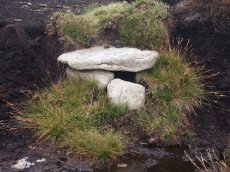
Hemstone Rocks N.1 Reported Cist
OS Map: SX 648 838
HER: MDV48854
ShortName: CT:Hemstone 1
Butler map: 35.7.1
Grinsell: LYD 17
Notes: See HER 6729 Lydford 17a
Nearby sites: SX 648 838
Distance: 1.61km
Lade Hill Brook W Round House
OS Map: SX 6364 8156
HER: MDV59475
ShortName: HT:Lade Hill33
Nearby sites: SX 6364 8156
Distance: 2.09km
Lade Hill Brook W Round House
OS Map: SX 6372 8187
HER: MDV59467
ShortName: HT:Lade Hill34
Nearby sites: SX 6372 8187
Distance: 1.81km
Lade Hill Brook W Round House
OS Map: SX 6370 8154
HER: MDV27272
ShortName: HT:Lade Hill35
Nearby sites: SX 6370 8154
Distance: 2.12km
Hemstone Rocks N.4 Cairn
OS Map: SX 648 838
HER: MDV6728
ShortName: CN:Hemstone 4
Butler map: 35.7.4
Grinsell: LYD 17c
Notes: Cairn, ne of hemstone rocks. Grinsell refers to a cairn at approx above ngr. Contained a pit in which were burnt bones, wood, charcoal and two burnt flints (grinsell).
Nearby sites: SX 648 838
Distance: 1.61km
Lade Hill Brook W Round House
OS Map: SX 6362 8183
HER: MDV59462
ShortName: HT:Lade Hill36
Nearby sites: SX 6362 8183
Distance: 1.82km
Lade Hill Brookhead Reported Cairn
OS Map: SX 638 824
HER: MDV6792
ShortName: CN?Lade Hill2
Butler map: 35.9
Grinsell: LYD 16a
Notes: A barrow 700 yards south of Grey Wethers (SX 68 SW 1) (which plots somewhere amongst the hut circles). It measures 16ft diameter and 9 ins high. Excavations in 1897/8 exposed a pit containing a little charcoal. No longer traceable.
Nearby sites: SX 638 824
Distance: 1.34km
Lade Hill Brook W Round House
OS Map: SX 6344 8205
HER: MDV59454
ShortName: HT:Lade Hill37
Nearby sites: SX 6344 8205
Distance: 1.57km
White Ridge S.W. Cairn
OS Map: SX 6414 8160
HER: MDV6770
ShortName: CN:White Rid2
Butler map: 35.11
Grinsell: LYD 19
Notes: Round cairn lying immediately west of an enclosed stone hut circle settlement in Great Stannon newtake (SX64158160). Diameter 7.2 metres, height 0. 9 metres. Kerb. Robbed. Central pit 2.2 metres by 0.8 metres by 0.1 metres deep. Grass covered mound with some edge set stones on the west side which may represent the remnants of a kerb. The orientation of the central pit is 123 degrees. Large number of stones protruding from the mound, many of which have quartz in them.
Nearby sites: SX 6414 8160
Distance: 2.21km
Lade Hill Brook W Round House
OS Map: SX 6356 8193
HER: MDV59460
ShortName: HT:Lade Hill38
Nearby sites: SX 6356 8193
Distance: 1.71km
Broad Down N.E. Cairn
OS Map: SX 63700 81010
HER: MDV6774
ShortName: CN BroadDown1
Butler map: 35.13
Grinsell: LYD 18
Nearby sites: SX 63700 81010
Distance: 2.62km
Lade Hill Brook W Round House
OS Map: SX 6345 8208
HER: MDV59456
ShortName: HT:Lade Hill39
Nearby sites: SX 6345 8208
Distance: 1.54km
Lade Hill Brook W Round House
OS Map: SX 6350 8208
HER: MDV55729
ShortName: HT:Lade Hill40
Nearby sites: SX 6350 8208
Distance: 1.55km
Lade Hill Brook W Round House
OS Map: SX 6353 8195
HER: MDV59457
ShortName: HT:Lade Hill41
Nearby sites: SX 6353 8195
Distance: 1.68km
Lade Hill Brook W Round House
OS Map: SX 6353 8193
HER: MDV59458
ShortName: HT:Lade Hill42
Nearby sites: SX 6353 8193
Distance: 1.70km
Teignhead Farm Round House
OS Map: SX 63828 84706
HER: MDV27280
ShortName: HT:Teignhead1
Nearby sites: SX 63828 84706
Distance: 1.27km
Lade Hill Brook W Round House
OS Map: SX 6353 8190
HER: MDV59459
ShortName: HT:Lade Hill43
Nearby sites: SX 6353 8190
Distance: 1.73km
Teignhead Farm SE Round House
OS Map: SX 6417 8375
HER: MDV54676
ShortName: HT:Teignhead2
Nearby sites: SX 6417 8375
Distance: 0.98km
Lade Hill Brook W Round House
OS Map: SX 6343 8206
HER: MDV59453
ShortName: HT:Lade Hill44
Nearby sites: SX 6343 8206
Distance: 1.56km
Grey Wethers E.1 Cairn
OS Map: SX 6411 8321
HER: MDV6806
ShortName: CN:Grey Weth 1
Butler map: 35.16
Grinsell: LYD 16
Notes: "A barrow is situated 274m e of grey wethers. Excavations in 1897/8 exposed a pit containing a little charcoal (baring-gould)." Fifth Report of the dartmoor Exploraion Committee
Nearby sites: SX 6411 8321
Distance: 0.99km
Lade Hill Brook W Round House
OS Map: SX 6346 8204
HER: MDV59455
ShortName: HT:Lade Hill45
Nearby sites: SX 6346 8204
Distance: 1.58km
Lade Hill Brook W Round House
OS Map: SX 6359 8188
HER: MDV59461
ShortName: HT:Lade Hill46
Nearby sites: SX 6359 8188
Distance: 1.76km
White Ridge Stone Row Cairn
OS Map: SX 6541 8165
HER: MDV6639
ShortName: CN:White Rid1
Butler map: 35.20
Grinsell: LYD 27
Nearby sites: SX 6541 8165
Distance: 2.95km
Hartland Tor N Reported Cairn
OS Map: SX 6413 8083
HER: MDV20488
ShortName: CN?Hartland 1
Nearby sites: SX 6413 8083
Distance: 2.92km
Grey Wethers E.1 (duplicate) Reported Cairn
OS Map: SX 6431 8329
HER: MDV20909
ShortName: CN:Grey Weth 4
Notes: Duplicate of HER 6806
Nearby sites: SX 6431 8329
Distance: 1.15km
White Ridge 3 Cairn
OS Map: SX 6502 8218
HER: MDV20915
ShortName: CN:White Rid3
Nearby sites: SX 6502 8218
Distance: 2.31km
Stonetor Brookhead E.1 Cairn
OS Map: SX 6532 8562
HER: MDV13027
ShortName: CN:Stonetor E1
Butler map: 37.2.1
Notes: ?
Nearby sites: SX 6532 8562
Distance: 2.93km
Shoveldown N.W.2 Cairn
OS Map: SX 6431 8630
HER: MDV54501
ShortName: CN:Shovel NW2
Butler map: 37.5.2
Notes: "a turf-covered cairn on the gentle w-facing slope of langridge overlooking the north teign river. It measures 5.5m in diam with a maximum height of 0.6m. The steeply sloping sides give way to a virtually flat top with a slight hollow sw of centre. There are no obvious signs of robbing or excavation (probert)"
Nearby sites: SX 6431 8630
Distance: 2.92km
Shoveldown N.W.3 Cairn
OS Map: SX 6436 8625
HER: MDV58684
ShortName: CN:Shovel NW3
Butler map: 37.5.3
Nearby sites: SX 6436 8625
Distance: 2.89km
Shoveldown N.W.4 Cairn
OS Map: SX 6438 8612
HER: MDV4395
ShortName: CN:Shovel NW4
Butler map: 37.5.4
Grinsell: GID 2
Notes: "The n cairn, probably that described by os and grinsell, measures 4.5m in diam and stands a maximum of 0.55m high. It possesses steep sides with some protruding stone and a very slightly hollowed centre. There are no obvious signs of disturbance (probert)"
Nearby sites: SX 6438 8612
Distance: 2.78km
Shoveldown N.W.5 Cairn
OS Map: SX 6439 8611
HER: MDV54481
ShortName: CN:Shovel NW5
Butler map: 37.5.5
Notes: "a probable mutilated cairn measures 3.6m n-s by 4.2m and 0.5m high on the n by 0.15m on the s. Though disturbed there is no distinct hollow usually associated with deliberate robbing. Some small stones protrude from the mound (probert)".
Nearby sites: SX 6439 8611
Distance: 2.78km
Shoveldown N.W.6 Cairn
OS Map: SX 6435 8593
HER: MDV58683
ShortName: CN:Shovel NW6
Butler map: 37.5.6
Nearby sites: SX 6435 8593
Distance: 2.60km
Lade Hill Reported Cist
OS Map: SX 63340 81841
HER: MDV-1
PMD: Lade Hill
ShortName: CT?Lade Hill1
Notes: Via Radcliffe: "A good candidate for a damaged cist. There is one long slab still in situ which is orientated 120/300 degrees. Other stones are rather jumbled and some look shattered, so I believe at some time it must have received a hit or near miss from an artillery piece - there are quite a few old shell holes on this hillside." (Information from TAP Greeves). No NMR or HER records.
Nearby sites: SX 63340 81841
Distance: 1.76km
Broad Down Reported Cairn
OS Map: SX 61940 80883
HER: MDV80630
ShortName: CN-BroadDown
Notes: Photo by Peter Brooks and reproduced here with his kind permission (copyright remains with Peter)."Peat cutter's shelter constructed from natural granite slabs 900 meters south of Sandy Hole Pass in an area of extensive peat cutting." Listed on the Modern Antiquarian as a cairn - but clearly a shelter. See: Broad Down Cairn
Nearby sites: SX 61940 80883
Distance: 2.99km
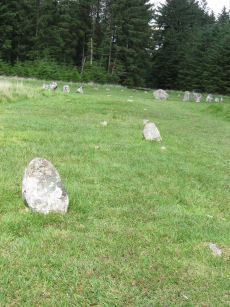
Fernworthy Stone Circle
Prehistoric Dartmoor Walks: Dartmoor Site: Fernworthy Stone Circle
OS Map: SX 65486 84126
HER: MDV6534
Megalithic Portal: 530
PMD: Fernworthy Stone Circle
ShortName: SC Fernworth
DPD page: 138
Turner: G13
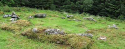
Notes: The Fernworthy circle is part of a group of ceremonial monuments including 3 stone rows and 5 cairns that may once have rivalled Merrivale and Shovel Down as ceremonial centres. The site is in a small clearing in Fernworthy Forrest off the path to Teignhead Farm. The circle is remarkably intact with all but 2 stones still in their original places ... It is 20m in diameter and consists of 27 small stones. The stone rows and cairns probably came later and surround the site. The circle was excavated by the Dartmoor Exploration Committee in 1897. They found that the interior of the circle was covered in a layer of charcoal suggesting that it had been the scene of very many fires - perhaps funeral pyres or feasts. See also Legendary Dartmoor: Dartmoor's Fernworthy Stone. DNP Post 3D.
Nearby sites: SX 65486 84126
Distance: 2.35km
Fernworthy Ceremonial Complex
Prehistoric Dartmoor Walks: Dartmoor Site: Fernworthy Stone Circle
OS Map: SX 6548 8412
HER: MDV6534
Megalithic Portal: 35937
PMD: Fernworthy
ShortName: CX Fernwthy
DPD page: 138
Notes: Lethbridge p.138
Nearby sites: SX 6548 8412
Distance: 2.34km
Fernworthy Settlement
OS Map: SX 648 837
HER: MDV6731
Megalithic Portal: 10485
ShortName: ST:Fernworthy
Nearby sites: SX 648 837
Distance: 1.60km
Fernworthy Cist
Prehistoric Dartmoor Walks: Dartmoor Site: Fernworthy Stone Circle
OS Map: SX 65491 84100
HER: MDV6719
Megalithic Portal: 35826
PMD: Fernworthy
Alternate name: Fernworthy 2 Cist
ShortName: CT Fernworth
Butler map: 35.15.2
Butler Vol 5: p.36 & Fig.13
DPD page: 138
Grinsell: LYD 23
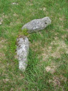
Notes: The remains of this cist are in the 6m diameter barrow at the N end of the Fernworthy S.E. stone row. The cist in the centre is represented by two stones set at right angles, 0.4m tall internally. Excavated by the Dartmoor Excavation Committee in 1898. A lot of burnt bone was found. DNP Post 6D. Butler Vol. 2. Map 35.15.2 (diagram Vol. 5. p.36 - row 2). Newman Barrow B.
Nearby sites: SX 65491 84100
Distance: 2.34km
Fernworthy (SW) Encircled Cairn
Prehistoric Dartmoor Walks: Dartmoor Site: Fernworthy Stone Circle
OS Map: SX 65483 84101
HER: MDV14885
Megalithic Portal: 35827
Alternate name: Fernworthy 3 Encircled Cairn
ShortName: EC FernworthyS
Butler map: 35.15.3
Butler Vol 5: p.36 & Fig.14
Grinsell: LYD 21
Turner: F25
Notes: Newman Barrow A. Small turf-covered cairn at the northern end of the western double stone row south of Fernworthy stone circle forming part of the Froggymead ceremonial complex. It measures 6.5 metres in diameter and has a central hollow resulting from excavation in 1898. Two rings of orthostats, 7m and 5m diameter, around cairn 4.5m diameter and 0.2m high (Turner). It once had a retaining circle of small stones but only three were visible in 2013. DNP Post 2D. Turner F25.
Nearby sites: SX 65483 84101
Distance: 2.34km
Fernworthy Barrow C Cairn
OS Map: SX 65485 84047
HER: MDV14887
Megalithic Portal: 35829
Alternate name: Fernworthy 4 Cairn
ShortName: CN:FernworthyC
Butler map: 35.15.4
Grinsell: LYD 22
Notes: Newman Barrow C.Cairn forming part of the cermonial complex at Froggymeade. Sitated at the southern end of the eastern stone row to the south of Fernworthy stone circle. It was excavated in 1898 but had previously been disturbed. Only one small flint flake was found.
Nearby sites: SX 65485 84047
Distance: 2.33km
Fernworthy E. Encircled Cairn
Prehistoric Dartmoor Walks: Dartmoor Site: Fernworthy Stone Circle
OS Map: SX 65561 84090
HER: MDV6560
Megalithic Portal: 3234
Alternate name: Fernworthy 5 Encircled Cairn
ShortName: EC:FernworthyE
Butler map: 35.15.5
DPD page: 138
Grinsell: LYD 24
Turner: F4
Notes: Newman Barrow D. "5.8m diameter. Has 3 stones spaced on the east side. A beaker, flint knife, dress fastener and a piece of bronze were discovered when the cairn was excavated in 1898". The crushed beaker. When reconstructed it became one of Dartmoor's most important Bronze Age finds and is now on display in Plymouth City Museum along with the other artifacts retrieved. DNP Post 7D.
Nearby sites: SX 65561 84090
Distance: 2.41km
Fernworthy N. Cairn
OS Map: SX 65539 84333
HER: MDV6563
Megalithic Portal: 35828
The Stone Rows of GB: Fernworthy 1
PMD: Fernworthy N Row
Alternate name: Fernworthy 1 Cairn
ShortName: CN FernworthyN
Butler map: 35.15.1
Grinsell: LYD 20
Notes: Newman Barrow E. Remains of a small cairn at the northern terminus of the double stone row north of the Fernworthy stone circle. The cairn has been damaged by past tree planting and the feature can be hard to identify as the remains are low to the ground and spread far beyond its original form. Radcliffe quotes Butler and also refers to HER/SMR number 6556 or 6562. "The 1898 plan shows a mound with a stone alongside as its northern terminus, probably a cairn, 1, with a retaining circle. This stone is still visible together with another at an angle, perhaps one side of a cist ..." (Butler Vol 2 pp. 164-5)
Nearby sites: SX 65539 84333
Distance: 2.45km
Fernworthy N. Stone Row
Prehistoric Dartmoor Walks: Dartmoor Site: Fernworthy Stone Circle
OS Map: SX 65538 84336
HER: MDV6562
Megalithic Portal: 1933
The Stone Rows of GB: Fernworthy 1
PMD: Fernworthy B Stone Row
Alternate name: Fernworthy 1 Stone Row
ShortName: SR Fernwthy N
Butler map: 35.15.1
DPD page: 138
Notes: Butler Row 1. "To the N of Fernworthy stone circle is a double stone row. At its N end are the disturbed remains of a barrow. The row survives well for 125m although beyond this (to the N) it has been heavily disturbed by forestry activity as far as the barrow. The plan of 1898, made prior to afforestation, shows the N end of the double row as already `buried or lost'. The surviving part of the double row contains paired, low stones 0.8m to 1.4m apart, averaging 0.3m high, although many are flush with the ground. The tallest stones are at the S end. The alignment of the row is tangential to the circle (SX 68 SE 56). The barrow at the N end of the row measures 6m in diameter, although it is very amorphous due to tree planting. there is a large proportion of stone in the centre of the low mound, as well as some amorphous scarping and one large upright slab." DNP Post 8D
Nearby sites: SX 65538 84336
Distance: 2.45km
Fernworthy S.E. Stone Row
Prehistoric Dartmoor Walks: Dartmoor Site: Fernworthy Stone Circle
OS Map: SX 6549 8407
HER: MDV6556
Megalithic Portal: 10484
The Stone Rows of GB: Fernworthy 2
PMD: Fernworthy C Stone Row
Alternate name: Fernworthy 2 Stone Row
ShortName: SR Fernwthy SE
Butler map: 35.15.2
DPD page: 138
Notes: Butler Row 2. "Centred at SX 65518404 is a cairn. 45m to the N at SX 65508409 is a barrow containing the remains of a cist. Between the two are the very fragmented remains of an alleged double stone row running N to S parallel to another row (SX 68 SE 59) which leads towards Fernworthy Stone Circle. The row, barrow and cairn have all been comprehensively damaged by afforestation and the digging of the adjacent drainage channels. Seven stones survive of an alignment but there is little evidence that it was a double row. The barrow at the N end of the row measures up to 6m in diameter and is 0.4m high, although its shape is obscured by drainage channels. The cist in the centre is represented by two stones set at right angles, 0.4m tall internally. The cairn at the S end of the row measures 7.3m N to S by 8.5m and is 0.5m high. There is a large amount of surface stone on and around it." DNP Post 5D.
Nearby sites: SX 6549 8407
Distance: 2.34km
Fernworthy S.W. Stone Row
Prehistoric Dartmoor Walks: Dartmoor Site: Fernworthy Stone Circle
OS Map: SX 65479 84105
HER: MDV14886
Megalithic Portal: 1934
The Stone Rows of GB: Fernworthy 3
PMD: Fernworthy A Stone Row
Alternate name: Fernworthy 3 Stone Row
ShortName: SR Fernwthy SW
Butler map: 35.15.3
DPD page: 138
Notes: Butler Row 3. "A disturbed double stone row is centred SX 65488408. It is 21m long and is oriented N to S. At the N end is a cairn (SX 68 SE 58) offset slightly W of the alignment of the row. Beyond this to the N is Fernworthy Stone Circle (SX 68 SE 56). The S end of the row is not very well preserved. The plan of 1898 depicts it terminating at a stone in the face of a wall, although the wall has since been removed. The stones in the row average 0.5m to 0.6m tall and lie in an area of amorphous modern earthworks up to 0.3m deep." DNP Post 1D.
Nearby sites: SX 65479 84105
Distance: 2.33km
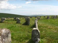
Grey Wethers (N) Stone Circle
Prehistoric Dartmoor Walks: Dartmoor Site: Grey Wethers Double Stone Circle
OS Map: SX 63875 83161
HER: MDV6758
Megalithic Portal: 532
PMD: Grey Wethers Stone Circles
ShortName: SC Grey Weth N
DPD page: 134
Turner: G4
Notes: "Northern stone circle of the pair known collectively as The Grey Wethers. This circle measures 31.5 metres in diameter and is denoted by 20 upright granite slabs with an average height of 1.1 metres. Excavations carried out by the Dartmoor Exploration Committee towards the end of the 19th century revealed a layer of charcoal covering the original ground surface. A shallow trench visible leading through the southern circle may be the result of this excavation. The circle was restored at this time"
Nearby sites: SX 63875 83161
Distance: 0.81km
Grey Wethers (S) Stone Circle
Prehistoric Dartmoor Walks: Dartmoor Site: Grey Wethers Double Stone Circle
OS Map: SX 63874 83121
HER: MDV6759
Megalithic Portal: 532
PMD: Grey Wethers Stone Circles
ShortName: SC Grey Weth S
DPD page: 134
Turner: G2
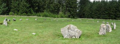
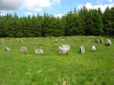
Notes: This site is one of the most impressive on Dartmoor. The circles were restored in 1909 by Burnard. At the time only 9 stones remained standing in the north circle and 7 in the south circle. It is thought that the reconstruction is fairly accurate. The circles are separated by a few meters and are almost identical. Both circles have 30 stones and diameters very close to 33 m and they are within 2 degrees of being on an exact north to south alignment. The slight differences between the two circles could even be a result of the restoration. Apparently "wether" is an old English name for sheep and legend has it that a drunken farmer leaving the Warren House Inn was persuaded that the Grey Wethers were a desirable flock for sale! See also, Legendary Dartmoor: Grey Wethers
Nearby sites: SX 63874 83121
Distance: 0.83km
Hangingstone Hill Cairn
OS Map: SX 61704 86136
HER: MDV4377
Megalithic Portal: 45858
ShortName: CN:Hanging
Butler map: 41.5
Grinsell: LYD 6
Notes: "A low, flat-topped cairn located on the summit of Hangingstone Hill. It measures 17.5m north to south by 15.0m at base and is maximum 1.4m high. It is apparently composed of medium sized granite slabs and boulders with a thin and patchy covering of turf. An ovoid hollow, 3.1m north to south by 2.0m and 0.3m deep, containing the stump of the flag pole (noted in the Devon SMR) lies slightly east of centre. A Range Wardens' hut encroaches on the southern side of the cairn. A considerable amount of peat has built up or has been deposited on the eastern side elongating the mound by some 10m in this direction." Partially excavated and repaired in 2016, see HER record. Butler Map 41.5 (Vol 2).
Nearby sites: SX 61704 86136
Distance: 2.94km
Hemstone Rocks Platform Cairn Circle
OS Map: SX 64856 83806
HER: MDV6730
Megalithic Portal: 45619
PMD: Hemstone Rocks
Alternate name: Hemstone Rocks N.3 Platform Cairn Circle
ShortName: PC Hemstone
Butler map: 35.7.3
Grinsell: LYD 17b
Turner: E12
Notes: Next to Turner ring cairn D9. "Remains of a cairn 8.0 metres diameter and up to 0.2 metres high to the north of the hut settlement. There are two pits cut into it, probably the result of work carried out by the Dartmoor Exploration Committee in 1901." DNP Site 9F.
Nearby sites: SX 64856 83806
Distance: 1.67km
Hemstone Rocks Ring Setting Cairn and Cist
OS Map: SX 64852 83850
HER: MDV6729
Megalithic Portal: 52522
PMD: Hemstone Rocks
Alternate name: Hemstone Rocks N.2 Ring Setting Cairn and Cist
ShortName: CT Hemstone
Butler map: 35.7.2
Grinsell: LYD 17a
Turner: D9
Notes: There are 3 cairns in the vicinity and they are according to Newman [2013] impossible to match up with the old reports. These cairns were excavated by Baring-Gould in 1900. A flint flake was found in the cist. There is also a rectangular pit in this cairn which could be from the 1900 excavation. See also: MDV48854. DNP Site 8F. Butler Hemstone Rocks N. 1 - Vol. 2. Map 35.7. Central cist. Next to Turner Platform Circle E12.
Nearby sites: SX 64852 83850
Distance: 1.67km
Quintins Man Standing Stone
OS Map: SX 62101 83873
HER: MDV6765
Megalithic Portal: 45860
PMD: Quintins Man
ShortName: SSxQuintinsMan
Butler map: 34.1
Notes: "A cairn. The name implies a standing stone, but there is no knowledge of one in living memory." [worth] See also, Legendary Dartmoor: Dartmoor's Quintin's Man
Nearby sites: SX 62101 83873
Distance: 1.13km
Quintins Man A Ancient Pool
OS Map: SX 62102 83952
HER: MDV27278
ShortName: PO:QuintinsA
Notes: "Previously identified as a prehistoric barrow, survey work in 1995 suggested this to be a natural feature. One of over 40 'sacred' pools identified by Greeves (2019) that may have prehistoric origin. Lies north of the Quintin's Man cairn."
Nearby sites: SX 62102 83952
Distance: 1.15km
Quintins Man B Ancient Pool
OS Map: SX 62053 84056
HER: MDV127217
ShortName: PO:QuintinsB
Notes: "A pool measuring 20 by 16m. One of over 40 such 'sacred' pools identified on Dartmoor that are thought to have potentially been designed during the prehistoric period."
Nearby sites: SX 62053 84056
Distance: 1.23km
Quintins Man C Ancient Pool
OS Map: SX 61972 84365
HER: MDV127218
ShortName: PO:QuintinsC
Notes: "Pool north of Quintin's Man measures 12 by 8m. One of over 40 such 'sacred' pools identified on Dartmoor that are thought to have potentially been designed during the prehistoric period"
Nearby sites: SX 61972 84365
Distance: 1.45km
Shoveldown N.W. 5 Cist
Prehistoric Dartmoor Walks: Dartmoor Site: Shovel Down Ceremonial Complex
OS Map: SX 64389 86247
HER: MDV4394
Megalithic Portal: 45782
PMD: Stonetor Hill
Alternate name: Shoveldown N.W.1 Cist
ShortName: CT:Shovel NW5
Butler map: 37.5.1
Butler Vol 5: p.202 & Fig.145
Grinsell: GID 1
Notes: NB. NGR from PMD is SX64398640. "The remains of a Bronze age cairn and cist which form part of a cairn cemetery on Long Ridge, known locally as Langridge, overlooking the valley of the River North Teign. The cairn has a circular mound which measures 5.2 metres in diameter and 0.5 metres high. The cist measures 0.83 metres square by up to 0.47 metres deep. The capstone, which once covered the cist, now lies 0.7 metres NNW of the cist." Butler Shoveldown N.W.1. - Vol. 2. Map 37.5. (diagram Vol. 5. p.202).
Nearby sites: SX 64389 86247
Distance: 2.90km
Sittaford Stone Circle
OS Map: SX 63017 82814
HER: MDV110432
Megalithic Portal: 35327
PMD: Sittaford Tor
ShortName: SC Sittaford
Notes: Discovered by Alan Endacott in 2007 as described in Devon Archaeological Society Newsletter No. 117 January 2014. Circle consists of 30 recumbent stones and has a diameter of 32m. It is about 1km from the Grey Wethers which are to the ENE. It is on the same arc as the previously known circles in northeastern Dartmoor.
Nearby sites: SX 63017 82814
Distance: 0.81km
Sittaford Circle Outlier Standing Stone
OS Map: SX 63053 82805
HER: MDV110432
Megalithic Portal: 35327
ShortName: SS Sittaford
Notes: Sittaford Circle Outlier
Nearby sites: SX 63053 82805
Distance: 0.81km
Sittaford Tor Pound
OS Map: SX 6400 8287
HER: MDV6754
Megalithic Portal: 23218
ShortName: PD:Sittaford
Notes: "An oval enclosure lying within Great Stannon Newtake. It is defined by a 4.5m wide and 1.2m high rubble bank surrounding an internal area measuring 53.5m east to west by 39m north to south. An 8.3 metre wide entrance gap on the eastern side by a stony mound. The considerable size of the bank combined with its proximity to a number of ritual monuments within Great Stannon Newtake strongly supports that this enclosure is much more likely to have been used for ritual than domestic purposes and it has consequently been identified as a henge."
Nearby sites: SX 6400 8287
Distance: 1.08km
Sittaford Tor Ring Setting Cairn and Cist
OS Map: SX 63479 82641
HER: MDV21894
Megalithic Portal: 45792
PMD: Sittaford Tor
Alternate name: Sittaford Tor S. Ring Setting Cairn and Cist
ShortName: CT Sittaford
Butler map: 34.3
Butler Vol 5: p.183 & Fig.126
DPD page: 125
Turner: D25
Notes: "Cairn 5 metres in diameter, 0.75 metres high. Surrounded by two rings of kerb stones up to 0.75 metres high. Many stones forming the outer ring are recumbent. Mound material up to 0.2 metres high. Inner kerb is 2.8 metres diameter and the outer is 5 metres diameter. Slab in centre may be an intact cist. Grass and rushes. Animal poaching on western side of cairn.". "This mutilated kerbed cairn is situated on a peat-covered moorland slope below Sittaford Tor at 488m OD. It measures about 5m in diameter and comprises a probably (hidden) central cist set within twin concentric kerbs of granite slabs." Lethbridge photo bottom p.125. Butler Sittaford Tor S (Cairn 3) Vol. 2. Map 34.3 (p.112, also Butler Vol. 5. diagram p.183).
Nearby sites: SX 63479 82641
Distance: 1.00km
South Teignhead Platform Cairn Circle
OS Map: SX 64084 82827
HER: MDV20908
Megalithic Portal: 45611
PMD: South Teignhead
ShortName: PC S Teignhead
Butler map: 35.17
Butler Vol 5: p.157
Turner: E4
Notes: Oval cairn measuring 12.0m x 8.0m. It is flat-topped apart from a slight hollow in the centre. It appears to have multiple concentric rings of spaced small stones set on edge, with at least six rings being visible on its north side. To the south-east some stones are set at right angles to the rings. Butler in Volume 5 p.157 refers to a 14 x 6 m long cairn on the southern slopes of White Ridge. Presumably he refers to this site.
Nearby sites: SX 64084 82827
Distance: 1.17km

South Teignhead / White Ridge Stone Ring Cairn Circle
OS Map: SX 64168 82656
HER: MDV6754
Megalithic Portal: 35830
PMD: Teignhead Henge
Alternate name: South Teignhead Pound Stone Ring Cairn Circle
ShortName: RC White Ridge
Butler map: 35.18
Turner: A5
Notes: A small circular 'pound' about 0.5km SE of Grey Wethers. It measures 75ft (N-S) by 66ft; the bank composed of small stone and earth is 6-8ft wide and 3ft high. An entrance on the W has one door jamb standing.
Nearby sites: SX 64168 82656
Distance: 1.35km
Stonetor Brookhead E. Cist
OS Map: SX 6527 8563
HER: MDV13023
Megalithic Portal: 45807
PMD: Stonetor Brook Head
Alternate name: Stonetor Brookhead E.2 Cist
ShortName: CT:Stonetor E2
Butler map: 37.2.2
Butler Vol 5: p.201 & Fig.144
DPD page: 133
Notes: "A mutilated cist situated amongst peat cuttings on the moderate W slope of shovel Down. Only the N endstone, 0.6m long, remains in situ on the edge of a hollow 1.1m N-S by 0.9m and 0.2m deep. An irregular slab 0.15m thick, probably the disturbed coverstone, lies propped up on the endstone. There is no trace of a covering cairn". Lethbridge diagram p.133 and photo top p.133. Butler Vol. 2. Map 37.2 (diagram Vol 5 p.201).
Nearby sites: SX 6527 8563
Distance: 2.90km
Stonetor Hill Cairn Circle
OS Map: SX 6525 8547
HER: MDV49461
Megalithic Portal: 52273
Alternate name: Stonetor Hill 1 Cairn Circle
ShortName: CC:Stonetor 1
DPD page: 133
Turner: G12
Notes: Dubious site. "Two upright slabs situated in the shallow valley bottom above the headmire of the E arm of the Stonetor Brook. The slabs, 1.2m high, are positioned in line 1.0m apart and lie on the boundary of Gidleigh Parish and the Forest of Dartmoor, now Dartmoor Forest parish. The N face of the E stone has the letters 'GP' (Gidleigh parish). The S face is lichen covered. A deep water filled erosion hollow lies on the N side of these stones". Possibly site listed as Stone Circle G12 by Turner. For a photo of this site, see Boundary stone on Stonetor Hill
Nearby sites: SX 6525 8547
Distance: 2.77km
Stonetor Hill Stone Ring Cairn Circle
OS Map: SX 6520 8536
HER: MDV48856
Megalithic Portal: 3478
Alternate name: Stonetor Hill 3 Stone Ring Cairn Circle
ShortName: RC:Stonetor 3
DPD page: 133
Turner: A3
Notes: Possible pound? "The feature consists of a sub-circular earthern bank 25m in diameter and up to 0.4m in height. It is best preserved on the North side where the bank is well defined, flat topped and has a plan width of about 4.0m On the South side the bank has been spread and flattened but still survives to 0.5m in height as a prominent outward-facing scarp, where the natural ground surface falls away from the enclsure. There is no entrance through the bank."
Nearby sites: SX 6520 8536
Distance: 2.66km
White Ridge Standing Stone
OS Map: SX 64162 82653
HER: MDV6771
Megalithic Portal: 51338
PMD: South Teignhead
Alternate name: South Teignhead Standing Stone
ShortName: SS White Ridge
Butler map: 35.18
Notes: Possible recumbent standing stone. "A small circular 'pound' about 350 yards (sic) SE of Grey Wethers. It measures 75ft (N-S) by 66ft; the bank composed of small stone and earth is 6-8ft wide and 3ft high. An entrance on the W has one door jamb standing; this was excavated but nothing was found except a very fine flat stone on the subsoil which measured 9ft long by 3-4ft wide. Trial pits were dug inside the enclosure without success." TDA Vol. 34 pp.164 (1902)
Nearby sites: SX 64162 82653
Distance: 1.35km
White Ridge Stone Row
OS Map: SX 65420 81661
HER: MDV6642
Megalithic Portal: 4145
The Stone Rows of GB: White Ridge
PMD: White Ridge Stone Row
ShortName: SR White Ridge
Butler map: 35.20
DPD page: 125
Notes: "A double stone row, 620 ft in length from the centre of a cairn at the north end, running nearly due south and slightly downhill. Well preserved at the north end for a short distance but becoming more dilapidated as it approaches the newtake wall at the south end". Lethbridge diagram p.124 and photo top p.125.
Nearby sites: SX 65420 81661
Distance: 2.95km
Whitehorse Hill Cist
OS Map: SX 61735 85482
HER: MDV66367
Megalithic Portal: 29778
PMD: White Horse Hill
ShortName: CT Whitehorse
DPD page: 131
Notes: This cist was excavated in August 2011. It featured on an 1892 map by John Chudleigh in An Exploration of Dartmoor's Antiquities. It was re-discovered in 2001 and recently excavated. Carbon dating suggests it is Bronze Age in date. Dates for the top of the cist gives 2800-1890BC and for the bottom of the cist 3650-3100BC. Provisional carbon dates for artifacts suggest the remains are Bronze Age (1900-1500BC). Inside the cist an animal hide bag was found containing cremation remains including a number of artefacts including amber beads (amber would have been imported from overseas), wooden ear studs, a delicate bracelet studded with tin beads, a textile fragment with detailed leather fringing and a unique coiled bag.
There is some good coverage on the Legendary Dartmoor website, see: Whitehorse Kist 1, Whitehorse Kist 2 and Whitehorse Kist 3.
See also DNPA: Update on Whitehorse Hill Cist excavation and Dartmoor tomb treasure horde uncovered by archaeologists. Not listed in Butler - relevant map of area is Vol. 2. Map 41. Lethbridge pp.131-132
Nearby sites: SX 61735 85482
Distance: 2.38km
Whitehorse Hill Reported Stone Circle
OS Map: SX 62208 84940
HER: MDV130871
ShortName: SC:Whitehorse
Notes: "Possible features stone circle and row noted by Hemery (1983), though unconfirmed. Visited with DNPA archaeologist in April 2021. In a very ruinous condition with vegetation covering the majority of the ?stone row."
Nearby sites: SX 62208 84940
Distance: 1.67km