
Prehistoric sites within 2km of SX 62600 67900
Guidance for walkers: The monuments featured in this database are archaeological treasures and need to be protected and preserved - please do not disturb any sites. Please check access and firing times before visiting sites, not all sites listed are on open access land. Firing ranges and boundaries of open access areas are marked on the OL28 OS Dartmoor Explorer map. Please stick to the country code and consider giving support to the numerous agencies that help to keep Dartmoor a fabulous natural and historic environment!
About the database listings: In all listings clicking on the photo or the site name will open a page for the site with a larger photo and further details from the database. The database now has over 6680 records covering nearly all publicly listed sites on Dartmoor including around 4800 round houses. This level of detail is of interest to archaeologists but tends to swamp listings of sites more likely to be of interest for walkers. For this reason, the listings default to around 550 core sites only. These are the stone circles, stone rows and the ring cairns listed by Turner. The default search radius is 2 km. The controls below the map can be used to start a new search by entering a 6- or 8-digit reference (without the prefix "SX"). The search radius can be specified and you can add incremental Display layers of detail on top of the core sites. If using a more detailed layer you will need to decrease the search radius to avoid getting hundreds of search results.
- Core sites Default listing of core sites consisting of stone circles & rows and some of the major ring cairns.
- Plus cairns adds approx. 1000 cairns and other minor sites not included in the core listings but excluding round houses.
- Plus round houses adds approx. 4800 round houses.
- Plus non-sites adds in the records for sites that no longer exist or are not prehistoric sites.
- Plus duplicates adds records excluded as duplicates. Those maybe duplicate records in external listings (e.g. the Historic Environment Records). For example, some sites have been identified as cairns in some listings and interpreted as round houses in other listings and both records appear.
These listings have incorporated, matched up and merged all of the records from all of the major archaeological listings including: Worth, Grinsell, Turner, Butler, Bill Radcliffe, Sandy Gerrard, Megalithic Portal, the National Monument Records and the Historic Environment Records. The author would like to thank Bill, Sandy, the lovely people both at Megalithic Portal (especially Anne Tate who did an amazing job to link listings) and at ACE Archaeology for collaborative work over the years to synchronise and correct listings across the various websites which now interlink. A culmination of years of work the final merger of cairn records took 3 months of cross referencing in 2017 the result being a snapshot of the records at that time. This data has in turn been refined since by field work and research. The round house data was supplied by Sandy Gerrard. Grid references are in order of accuracy: from Google Earth satellite, if visible and found, from a Garmin GPS reading, if visited by the author and from the literature otherwise. Individual site pages will state the source of the grid reference and provide satellite imagery. If a site listing lacks a photo it has not yet been visited by the author in which case the grid reference is from the literature.
Currently the database only includes sites which can be represented by a grid reference. Reaves are not included as they require GIS shape technology which is beyond the current capability of this system. To see the sources for the records, look at the tables on the resources menu. The database listings can also be viewed on a Google map and downloaded as GPS datasets for Garmin devices.
Corrections, or any feedback or suggestions are very welcome, email: info@dartmoorwalks.org.uk.
NOTE: Clicking on the icons for each monument in the map will give the name of the site. You can zoom in and out and drag the map around.
List of sites within 2km of SX 62600 67900
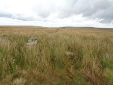
Calveslake Cist
Prehistoric Dartmoor Walks: Dartmoor Site: Guide to the Langcombe Brook & Deadman's Bottom Cists
OS Map: SX 60874 67551
HER: MDV5085
Megalithic Portal: 45660
PMD: Calveslake Tor
Alternate name: Calveslake Tor Cist
ShortName: CT Calveslak
Butler map: 50.4
DPD page: 43
Grinsell: SHA 3
Barrow Report: 12 19
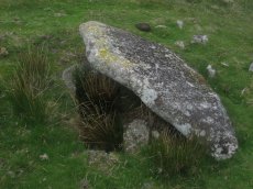
Notes: "A perfect, well constructed cist at Calveslake. Length, 3ft 7inches; width at north end,1ft 7 1/2 inches; at south end, 1ft 9inches, depth to floor, 2ft 7inches. An irregular shaped cover-stone overhangs the eastern end of the cist. The barrow in which the cist stands has a diameter of 18 feet." Lethbridge Calves Lake cist p.42-43, diagram p.42. Butler Calveslake Tor - Vol. 3. Map 50.4 (diagram p.154).
Nearby sites: SX 60874 67551
Distance: 1.76km
Deadmans Bottom F Platform Cairn Circle and Cist
Prehistoric Dartmoor Walks: Dartmoor Site: Guide to the Langcombe Brook & Deadman's Bottom Cists
OS Map: SX 61201 66983
HER: MDV5125
Megalithic Portal: 45733
PMD: Deadman's Bottom E.
Alternate name: Langcombe Brook 11 Platform Cairn Circle and Cist
ShortName: CT Deadmans F
Butler map: 50.3.11
DPD page: 43
Grinsell: SHA 12
Barrow Report: 53
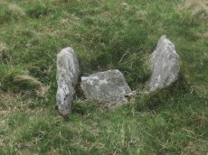
Notes: "Cist (Listed as 'F' by Worth) found at Deadman's Bottom, Langcombe, by Mr. Button. The cover-stone is still in position but the cist appears to have been rifled, the end and side-stones having been displaced at the north-east and southwest angles. Original length would appear to have been 2 feet 10 inches, and the width 1 foot 7 inches. The greatest length of the cover-stone is 4ft 9 inches and its greatest width 3 feet 1 1/2 inches." ... "A flat-topped cairn measuring 5.4m in diameter and standing a maximum of 0.4m high. A well-preserved cist 1.3m long, 0.6m wide and 0.15m deep is largely obscured by the coverstone". Lethbridge p.43 Langcombe Cist A (Upper Deadman's Bottom) - diagram p.43. nb. Not listed by Turner - assigned as "Platform Circle" type cairn due to description in NMR. Butler Langcombe Brook Cairn 11 - Vol. 3. Map 50.3 (pp.148-54 general plan of Langcombe Brook cairns p.151, diagram of Langcombe cists p.153).
Nearby sites: SX 61201 66983
Distance: 1.67km
Great Gnat's Head Cist
OS Map: SX 61174 68034
HER: MDV5091
Megalithic Portal: 45675
PMD: Great Gnat's Head
Alternate name: Great Gnats Head 1 Cist
ShortName: CT GreatGnats1
Butler map: 50.5.1
DPD page: 42
Grinsell: SHA 1
Barrow Report: 20
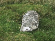
Notes: "Cist measures a maximum 1.0m long by 0.70m internally and 0.7m deep. Two side slabs and a fallen end slab are extant. There is no trace of a cover stone.". Lethbridge (near Abbot's Way cist) photo and diagram p.42 Butler Great Gnat's Head 1 - Vol. 3. Map 50.5 (diagram p.155).
Nearby sites: SX 61174 68034
Distance: 1.43km
Great Gnats Head Cairn
OS Map: SX 61657 67908
HER: MDV13177
Megalithic Portal: 45861
Alternate name: Great Gnats Head Summit 4 Cairn
ShortName: CN GreatGnats4
Butler map: 50.5.4
Grinsell: SHA 2
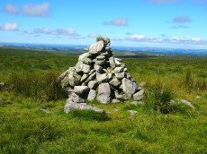
Notes: "A Bronze Age summit cairn, now badly disturbed by a conical walkers cairn built in the SW quadrant. It measures 8.5m in diameter, the outer slope is 0.3m high and the interior is scooped to a depth of 0.3m -small boulders and upright slabs are visible. The conical cairn is 2.6m in diameter and 1.5m high." Butler Volume 3 Map 50.5.
Nearby sites: SX 61657 67908
Distance: 0.94km
Green Hill Cairn
OS Map: SX 63665 67796
HER: MDV5106
Megalithic Portal: 2143
PMD: Green Hill
ShortName: CN GreenHill
Butler map: 55.7.4
DPD page: 72
Grinsell: LYD 101
Barrow Report: 14
Notes: "Cairn on the summit of Green Hill is the northern terminal of the stone row (SX 66 NW 20 but see also SX 66 NW 101 for cairn which may extend the row). Diameter 9m, height 0.7m. The possible remains of a central cist are indicated by a group of large stone slabs".
Nearby sites: SX 63665 67796
Distance: 1.07km
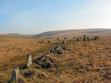
Stall Moor (Upper Erme) Stone Row
Prehistoric Dartmoor Walks: Dartmoor Site: Upper Erme Stone Row & Cairn Circle
OS Map: SX 63663 67796
HER: MDV4309
Megalithic Portal: 1464
The Stone Rows of GB: Upper Erme
PMD: Stall Moor Stone Row
Alternate name: Upper Erme Row Stone Row
ShortName: SR Stall Moor
Butler map: 55.7
DPD page: 71
Notes: Worth: Stall Moor. Butler: Upper Erme. The longest stone row on Dartmoor. "A single stone row running for approximately 3.1km from a cairn on Green Hill to a stone circle on Stall Moor". Lethbridge pp.71-72, diagram p.71
Nearby sites: SX 63663 67796
Distance: 1.07km